9 F. high in the Twin Cities Sunday.
24 F. average high on January 20.
12 F. high on January 20, 2012.
Trace of snow fell yesterday at KMSP.
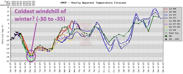
Windchill Warning in effect this morning. Wind makes it feel like -30 to -35 F.
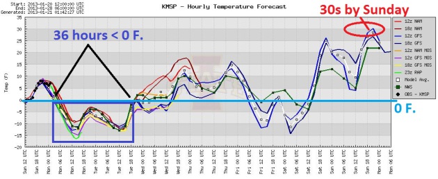
36+ hours below zero (until midday tomorrow).
30s return Sunday thru Tuesday of next week.
Numb and Number
"Hey, by Sunday we should see freezing" I
mumbled to my wife yesterday, from the relative safety of my favorite
couch. "Alright!" she cheered. Kind of sad huh?
A metaphysical question: can you feel any colder
than NUMB? Think about that. A 35 below wind chill will cool down your
core body temperature faster, meaning hypothermia risk; frostbite on
exposed skin possible within 5 minutes
The same with your vehicle. Cars don't "feel"
wind chill, but cold air temperatures will chill your engine block down
much faster. A battery-draining Monday, but not close to the record cold
daytime high of -17 F, in 1888. Windchill Warnings are posted; today easily the coldest day of the week, probably the entire winter. Take the chill seriously.
A whopping inch of snow may fall Thursday,
followed by a reinforcing shot of numbing air Friday, although not as
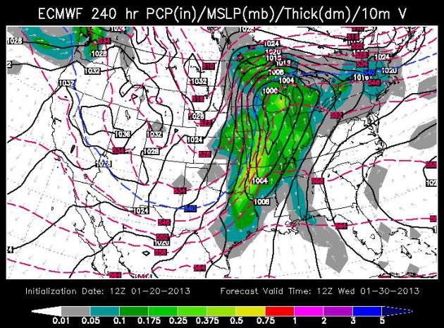
cold as today. ECMWF (European) model guidance shows 32-35 F by Sunday.
It will feel 70 F degrees warmer by early next week. A reason to keep on
going.
An average January brings 13 inches of snow to
MSP. So far this month: 1.4 inches. Speaking of sad. A few models bring a
chance of snow into town by the middle of next week, but I'm skeptical.
Everything now is viewed thru the prism of lingering drought. Getting
any heavy precipitation (rain or snow) is the meteorological equivalent
of swimming upstream.
Keep your snowy expectations low.
* thanks to Andrea Bouzrara for passing on the
photo above. That's her son, Sami, and his BFF Tommy. Forget the
lemonade - when it's 5 F. you want to be selling hot chocolate!
Coldest Morning Of Winter? The air temperature
Tuesday morning may be a few degrees colder (due to clear skies and less
wind), but factoring wind I suspect this morning will have the dubious
distinction of the coldest morning of the Winter of 2012-13. Models show
morning windchills ranging from -30 to -40 F in the metro. Like
breathing in battery acid.
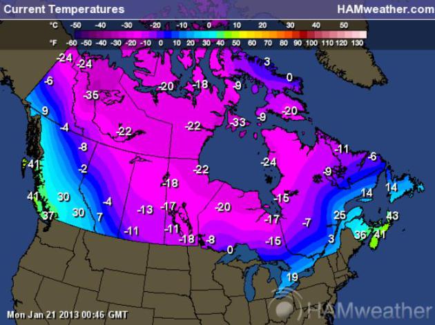
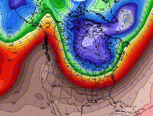
Oh Canada. Here are air temperatures (not wind
chill) as of 7 pm Sunday evening, showing the extent of subzero air to
our north. We'll see our fair share into midday Tuesday, another (brief)
dip below zero the end of the week, but the core of this
battery-draining, pipe-rupturing air will track just to our north and
east. For the latest temperatures over Canada
click here, courtesy of Ham Weather.
Why Most Of America Is Scared Of Minnesota (At Least In January).
We live up to the legend over the next 24-36 hours; getting our Winter
Weather Mojo back, at least temporarily. All models keep metro air
temperatures below zero until midday tomorrow, when readings may creep
just above 0 F. Slight moderation Wednesday & Thursday, then a
reinforcing shot Friday & Saturday (although not as cold as today).
We finally thaw into the 30s early next week. Let the party begin.
Graphic: Iowa State.
Too Early To Panic - Or Celebrate. The European
model spins up a significant storm over the Midwest and Great Lakes by
Wednesday of next week, but once again the most significant moisture may
pass south/east of Minnesota. It's too early, but at least there's a
chance of some accumulating snow the middle of next week. Map above
valid 7 am Wednesday, January 30, courtesy of WSI.
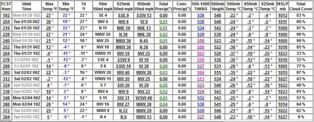
Extended Outlook: Cold, But Not Polar. Temperatures
right now at 850 mb. (about 3,500 feet aloft) are -25 to -27 C, marking
the coldest readings in sight looking out 2 weeks. Temperatures at 850
mb are forecast to briefly drop to -22 early Saturday, February 2. We'll
see a few more subzero nights into early and mid February, but I still
believe this week will wind up as the coldest of the winter, all things
considered.
Ask Paul. Weather-related Q&A:
Paul,
"In the last few weeks we've gone from above freezing temperatures to precipitous drops in temperature. Is there any regularity to this, or is it just
the normal variation in the weather and the warm days were just as
likely to be followed by temperate days?"
Russ Ludeke
St. Paul
Russ - chalk this up to normal atmospheric variability. We've been
pampered, spoiled in recent winters, especially last winter, when a
strongly (freakishly) positive phase of the Arctic and North Atlantic
Oscillation kept steering winds aloft howling from west to east, keeping
the coldest air of winter dammed up north of Minnesota - meaning only 3
subzero nights. This winter there's more variation to the upper level
pattern, more dips and bulges capable of pushing Arctic air south. We
had a mild start to winter; I suspect colder than average weather into
the first week or two of February, but I'm still betting that the entire
winter will be (slightly) milder than average, overall. Maybe that's
wishful thinking.
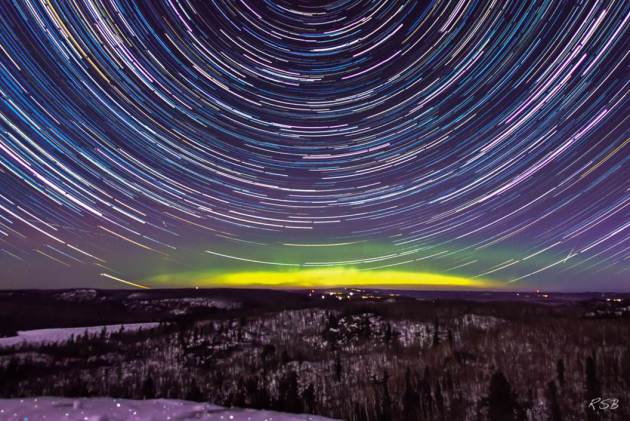
Blog-Worthy. Thanks to the prolific and creative Steve Burns for passing this remarkable photo along. Details: "
On
Thursday night the Aurora was supposed to be active, so I headed north
of the cities to a place on the North Shore to camp ouut and hopefully
see some action. On the drive up there mi-day the kp was high and the
magnetic field very negative, but right after sunset things started to
die down. I was able to see some good activity on the horizon, and with
my fast 50 mm. lens I was able to get some good time lapse action. I had
two cameras set up. This one stayed in place and didn't move, so I made
an image with the star trails and the aurora that I think turned out
pretty well. I was on top of Mt. Trudee outside of Silver Bay, where
temperatures were -10, and it was windy. Still beautiful!"
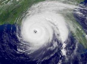
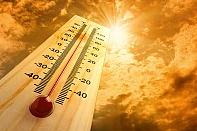
Editorial: Florida Gets An Early, And Very Bad Hurricane Warning.
The availability of low-orbiting "POES" satellite data made a huge
difference, initial data fed into NOAA supercomputers that predicted
Sandy would hook inland over New Jersey, days in advance. But those
satellites are predicted to fail before new replacements can be
launched, and (surprise) the entire debate is being debated by Congress.
Here's a snippet of an Op-Ed at
The Palm Beach Post: "...
Our
polar satellites, though, are at the end of their useful life, and the
program to replace them is far behind. With the earliest possible
launch projected for 2017, it is nearly certain that forecasters will
face several storm seasons without the polar satellite data that has
made hurricane predictions steadily more reliable. Bungling by the
National Oceanic and Atmospheric Administration has led Congress to
demand reforms before throwing more money at the program. NOAA has been
trying. Several officials responsible have left. More are resigning.
But the technical and budgetary woes remain. Government scientists have
now appealed to American and international experts, hoping they can
devise stop-gap measures to compensate for the loss of satellite data..." (Hurricane image above: NASA).
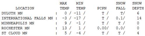
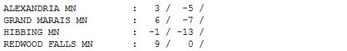
An Even Colder Cold Front. Yesterday my family was
complaining about the cold. I mentioned that an even colder cold front
was on tap for today. They looked at me like I had horns. Hey, I'm just
the messenger! Sunday highs ranged from -3 at International Falls to -1
Hibbing, 0 at Duluth, 5 St. Cloud, 9 in the Twin Cities and a balmy 13
at Rochester. Yes, today will be 10-15 F. colder.
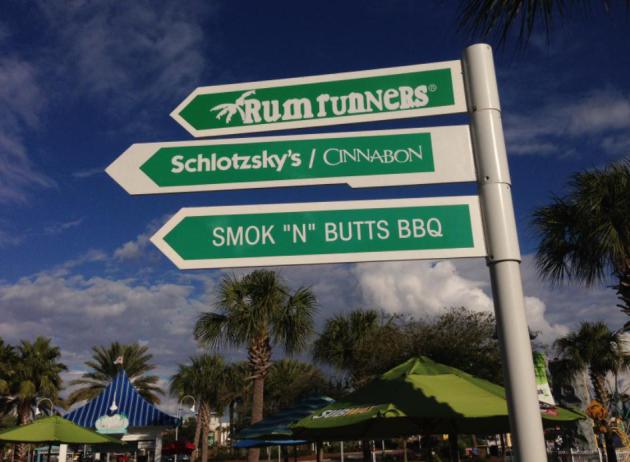
I'm There. I snapped this photo at an outdoor
shopping mall in Panama Beach, Florida back in early December. I am all
out of cold weather photos - thought this might warm you up a little.
Paul's Conservation Minnesota Outlook for the Twin Cities and all of Minnesota:
TODAY: Windchill Warning. Siberian sunshine - coldest of winter. Feels like -35. Winds: NW 15. High: -4
MONDAY NIGHT: Coldest air temperature of winter? Partly cloudy. Low: -14
TUESDAY: Mix of clouds and sun. Less wind. High: 3
WEDNESDAY: A fine Arctic breeze. Some sunshine. Wake-up: -5. High: 9
THURSDAY: Maybe an inch of snow. Wake-up: 4. High: 15
FRIDAY: Last harsh day this week. Bitter breeze. Wake-up: 1. High: 6
SATURDAY: Sunny, getting better out there. Wake-up: -4. High: near 20
SUNDAY: Badly-needed thaw likely - plenty of sun. Wake-up: 8. High: 33
* highs reach the 30s the first half of next week; a potential for snow by the middle of next week. Stay tuned.
Climate Stories....
Prepare For Impact of Climate Change. Here's an excerpt of an Op-Ed from the Editorial Board at
The Star Tribune: "...
That
matches the conclusion of the U.S. Global Change Research Project,
whose new report earlier this month said the American Midwest could see
another 4.9-degree increase in average temperatures by midcentury.
That much heat, added to the 3-degree increase already seen in parts of
Minnesota in the last 30 years, would mean more and longer droughts;
more precipitation arriving in the form of damaging thunderstorms
accompanied by tornadoes; the retreat of coniferous forests; more
invasive plants and aquatic life, and longer growing seasons. Not all of
the changes are undesirable. For example, said agronomist Nicholas
Jordan, the ability of Minnesota farmers to grow perennial as well as
annual crops could enhance farm income..."
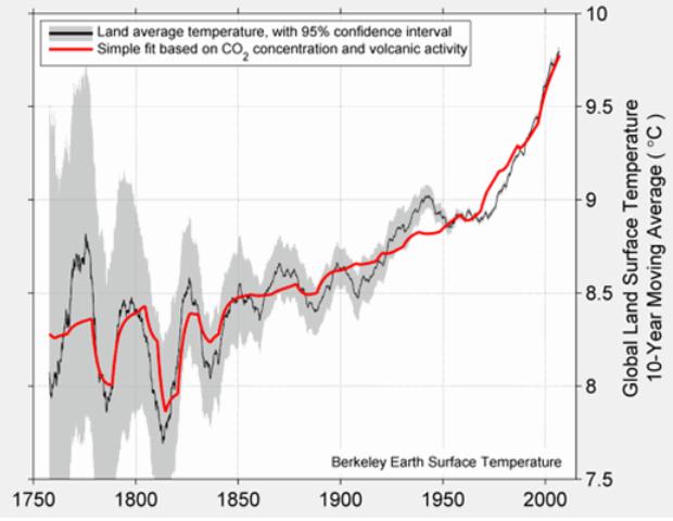
Koch-Funded Study Finds 2.5F Warming Of Land Since 1750 Is Manmade: "Solar Forcing Does Not Appear To Contribute." Joe Romm at
Think Progress has the story; here's an excerpt: "
The
Berkeley Earth Surface Temperature Study (BEST) has finally published
its findings on the cause of recent global warming. This Koch-funded
reanalysis of millions of temperature observations from around the
world, “A New Estimate of the Average Earth Surface Land Temperature Spanning 1753 to 2011,” concludes:
… "solar forcing does not appear to contribute to the
observed global warming of the past 250 years; the entire change can
be modeled by a sum of volcanism and a single anthropogenic
[human-made] proxy."
...
The finding itself is “dog bites man” (see It’s “Extremely Likely That at Least 74% of Observed Warming Since 1950″ Was Manmade; It’s Highly Likely All of It Was).
What makes this “man bites dog” is that Muller has been a skeptic of
climate science, and the single biggest funder of this study is the “Charles G. Koch Charitable Foundation ($150,000).” The Kochs are the leading funder of climate disinformation in the world!"
Graphic credit above: "
The decadal land surface
temperature from BEST average (black line), “compared to a linear
combination of volcanic sulfate emissions (responsible for the short
dips) and the natural logarithm of CO2 (responsible for the gradual
rise) shown in red. Inclusion of a proxy for solar activity did not significantly improve the fit. The grey area is the 95% confidence interval.”
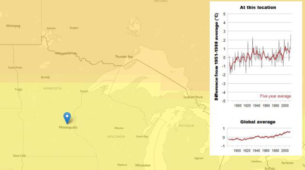
Interactive Tool Tracks Warming. This web site, from
New Scientist, allows you to move the cursor (anywhere on the planet) and see the extent of warming since 1900.


No comments:
Post a Comment