-10 F. low temperature in the Twin Cities Monday morning.
-2 F. high at KMSP yesterday, first subzero day in 4 years (1,466 days).
24 F. average high on January 21.
22 F. high on January 21, 2012.
Trace of flurries yesterday in the metro area.
Thaw likely by Sunday as temperatures approach or pass 32 F.
Coating to 1/2" snow possible late Thursday into Friday; still no major snowstorms in sight.
Remember When It Snowed...A Lot? I don't have a
specific year for this photo (1940s or 1950s, based on how he's dressed
above), but it certainly wasn't in the recent past. Thanks to
photographer Bill Koch at the NorthDakota State Highway Department,
courtesy of Dr. Herbert Kroehl, NGDC.
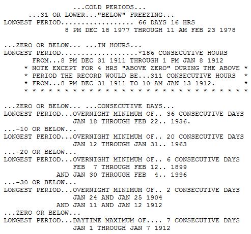
Cold Perspective
Minnesotans really had something to complain
about in 1936: 36 subzero nights in a row in January & February,
followed by 5 consecutive days above 100F in July. From freezer to the
frying pan.
We may wind up with 36 hours/row below zero here in the metro, air temperatures creeping above zero this afternoon.
A far cry from 1911-12, when subzero weather
gripped the metro for 186 hours/row. Factoring in 4 hours above zero -
it was a 311 hour stretch colder than 0F.
Ouch. More recently the winter of 1976-77 saw 23
consecutive nights below zero; the following winter: 66 days/row colder
than freezing.
1996 brought blizzards out west and 6 nights colder than -20F in the metro! Bottom line: it could be worse.
We're waking up to what will probably be the
coldest air temperature of winter, but winds have eased - the wind chill
not quite as newsworthy.
It's a bit surreal being this cold (yet so
brown). Note to self: if we had 6-12 inches of snow on the ground this
latest outbreak would have been at least 10 degrees F. colder.
Friday flurries (coating to maybe a half inch of
snow) give way to yet another cold smack late week; we should thaw out
by Sunday.
A big storm spins up by next Thursday, but just
like the others it may track south/east of Minnesota. Yes, we're stuck
in a deep, dry rut.
* amazing animated gif above, showing the progression of seasons, courtesy of Eirik Solheim at
eirikso.com.
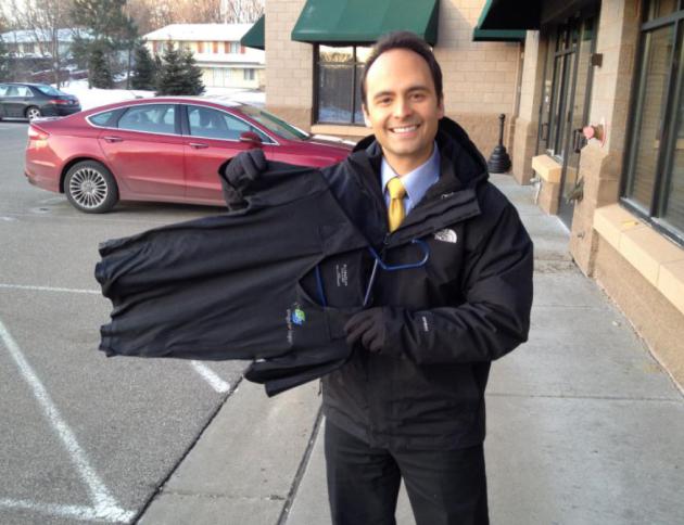
That's
WeatherNation TV meteorologist Todd Nelson, who took a wet shirt outside
Monday morning, and was SHOCKED when it froze solid within seconds.
Imagine that.
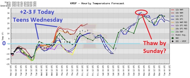
Nowhere To Go But Up. Most models are indicating a
high (just) above 0F. later today, breaking our subzero streak at 36
hours, give or take. Teens are expected Wednesday, followed by a brief
temperatures plunge late Friday and early Saturday. You'll be pleasantly
surprised how good low 30s will feel by Sunday afternoon. Graphic: Iowa
State.
Cold Weather Perspective. Yes, it's cold out there,
but this Arctic front pales in comparison with what we endured in 1996,
1976-78 and 1911-12. Those were real winters. Information above courtesy
of the
Minnesota Climate Office.
Bitter....and Brown. It's still a
disconnect: subzero readings with a dire lack of snow from the Twin
Cities on south and east. The ECMWF shows a coating of snow late
Thursday into Friday morning (ahead of the next weak clipper), followed
by a welcome warming trend early next week.
Atmospheric Payback. After an unusually mild
December across most of the USA, Old Man Winter is (finally) making up
for lost time, with subzero weather skirting the northern tier states.
Why was last January so balmy, in comparison with this winter? How is a
lack of snow over northern states impacting the severity of the cold.
Here's the latest installment of "Climate Matters", courtesy of
WeatherNation TV and
YouTube: "
Are
you feeling the bitter cold yet? Folks in the Midwest already watched
their temps nosedive. Folks in the eastern states next. Meteorologist
Paul Douglas looks at the winter so far and how it compares to
previous years. What do you think?"
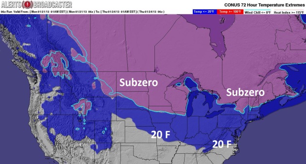
Extent Of Subzero Air. By 1 am Thursday temperatures
will be below zero over northern New England, 20s pushing into the
Virginias and Tennessee. The map above, based on GFS data, shows a 72
hour forecast, showing the southward extent of the 0F and 20F isotherm,
courtesy of Ham Weather and Alerts Broadcaster.
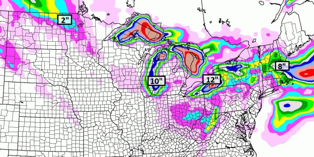
Mostly Lake Effect. The NAM model (above) prints out
10" downwind of Lake Michigan, some 12"+ amounts near Cleveland and
Buffalo, maybe as much as 4-8" in the Boston area later this week as
bitter air spins up a coastal storm. This map shows expected snowfall by
the end of this week.
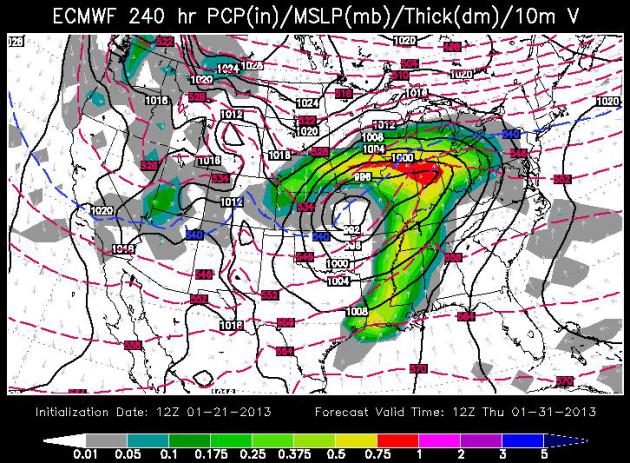
Next Week: Another Close Encounter? The ECMWF model,
valid 7 am next Thursday, January 31, shows a storm spinning up near
Kansas City, throwing a shield of snow into Iowa and far southeastern
Minnesota. There's a good chance this storm will also take a track that
keeps the heaviest snow south/east of our fair state. It's too early to
say with any confidence, but it would be a good idea to keep your snowy
expectations low until further notice. Map above: WSI.
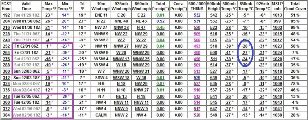
Early Spring? Don't Bet On It.
Long range (GFS) guidance shows a few more healthy cold fronts surging
south of the border, hinting at another subzero outbreak the first few
days of February. I suspect we'll get off to a cold start to February,
with some Pacific moderation by mid-month.
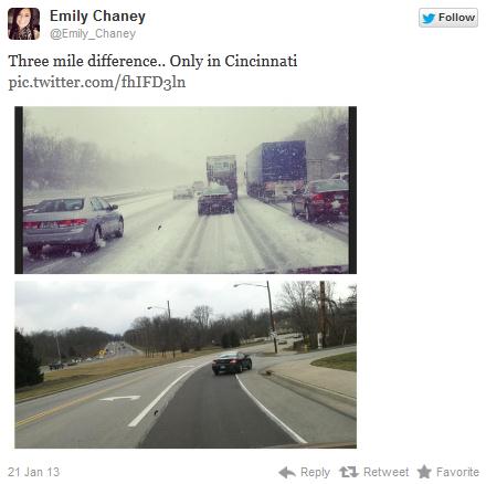
Freak Snow Squall Leads To Disaster in Cincinnati.
Thanks to Emily Chaney and Twitter for showing what a difference 3 miles
can make during the winter. A snow squall drifted over Cincinnati
Monday, leading to white-out conditions, and a tragic, multi-vehicle
accident (scores of vehicles may have been involved) that claimed at
least one lift. Details from wcpo.com
here.
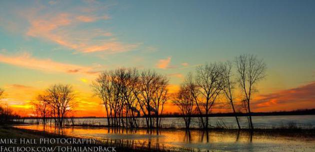
A Zen Moment In January. Mike Hall snapped this photo near Lewisport, Kentucky over the weekend, a magical sight courtesy of
Facebook.
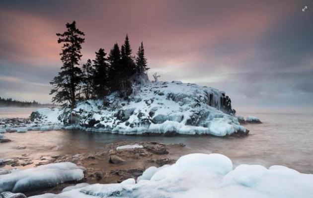
"Cold Enough Out There For You?" I love this photo, courtesy of Bryan Hansel Photography, via
Facebook and WeatherNation TV, who writes: "
When
I left my house this morning, it was -24F. On the Lake Superior shore
at my favorite tombolo/island, it was -17F. With the wind chill it was
about -32F. The temp is dropping, too. It's now -27F with a wind chill
of -54F. I've never really understood the wind chill thing as the
temperature doesn't actually get colder, but I guess they use it because
it just feels colder. I guess it's
sort of like waves, when the wind blows the waves get higher. Maybe we
should make wind chill into a scale like the Beaufort sea scale. When
it's -54F wind chill, we could call it a Winter Force 7.
Anyway, enough winter musing. This morning, I ventured to my favorite
tombolo. It's east of Grand Marais by about 10 miles. To get to the
point where I set up my tripod, I had to wade across a gap (water was
flowing through it like a stream), slip across ice and then balance on
an uneven surface of glare ice. I waited for twenty minutes tucked into
my hood, while my glasses froze and my breath coated my collar with
rime. Then the pink happened."
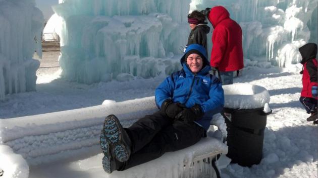
Lounging At The Palace. That's my old college buddy,
Weather Channel meteorologist Mike Seidel. When I get a call from him
(when he's flying up to MSP) I know that something big is brewing. He
was here to help us celebrate (?) the coldest air in 4 years, an old
fashioned Arctic Outbreak. One of his live shots was at the Ice Palace
down at MOA, which you should check out one of these days. Mike, please
return to Atlanta, so we can resume with our quiet, boring, blah winter.
"Leo, Do You Want To Go Out And Do Your Business?"
This is the look I got from my dog after asking that (stupid) question. I
could just hear him thinking "what do you think? NO!" I'm trying to
teach him to use the commode, but so far not much luck. What a YouTube
video that would make...
"We've got a problem here" "You think
you have a problem?"
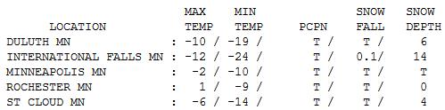
Cold Enough. Hey, we got our Winter Mojo back, at
least for a couple of days. Morning windchills dipped to -30 F in the
metro, as cold as -45 F. up north. After waking up to -24 F the "high"
at International Falls was a brisk -12 F. Elsewhere highs ranged from
-10 at Duluth (where schools have been cancelled tomorrow - can't
remember the last time THAT happened), to -6 St. Cloud, -2 Twin Cities
to 1 at Rochester, where there is no snow left on the ground.
Character-building indeed.
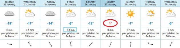
Paul's Conservation Minnesota Outlook for the Twin Cities and all of Minnesota:
TODAY: Zero has never looked better. Fading sunlight. Winds: W 5-10. High: 2 (above).
TUESDAY NIGHT: Partly to mostly cloudy. Low: -2
WEDNESDAY: Clouds increase, not quite as numb. High: 9
THURSDAY: Late coating of light snow. Wake-up: 0. High: 11
FRIDAY: Weak clipper. More light snow and flurries. Wake-up: 4. High: 16
SATURDAY: Cold start. Sun should be out. Wake-up: -2. High: 10
SUNDAY: No need to hibernate. A thaw! Dim sun. Wake-up: 8. High: 33
MONDAY: Clouds increase, still mild. Wake-up: 20. High: 31
Climate Stories....
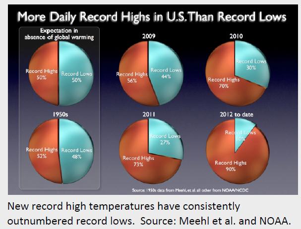
Warming Trend. If the atmosphere over the USA wasn't
warming you'd expect the number of record highs and record lows to be
comparable. Not so. You can see the progression of record highs vs. lows
since 2009, compared to the decade of the 1950s (lower left). Graphic:
Climate Nexus.
More Global Weather Extremes.
Huffington Post has an eye-opening account of some of the recent extremes around the planet; here's an excerpt: "
Newest Extreme Weather Casualty: Jakarta, Indonesia, a megacity of 10 million, is underwater, paralyzed, reports
Sarah Schonhardt at the Christian Science Monitor, from extreme
downpours, causing extreme flooding, and threatening investment... move
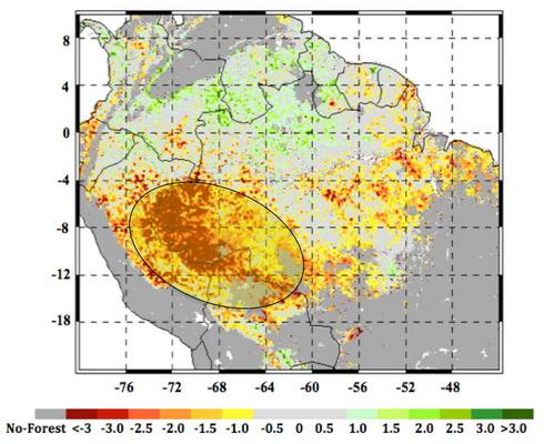
over, Manila... Amazon Drying Out, Likely From Climate Change, a new NASA study indicates, reports
Bailey Johnson at CBS News online. A megadrought that began in 2005
has persisted, and the area is showing widespread signs of not
recovering quickly enough to withstand the new frequency of droughts
occurring...."
Map credit above: "
A satellite image of the 2005 drought, now megadrought, in the Amazon, with the worst imacts in red and yellow." (Credit: NASA/JPL-CALTECH/GFSC)
Averting Climate Change May Cost $700 Billion A Year. Here's an excerpt from a story at
Bloomberg: "
About
$700 billion a year of new spending on renewable power, low-carbon
transport and energy efficiency is needed to meet the United Nations
goal to cap temperature rises, a report for the World Economic Forum
showed. That cash is needed in addition to the $5 trillion a year
countries must spend on infrastructure for agriculture, transport, power
and water through 2020, according to a report released today by the
consultant Accenture Plc (ACN)
for the forum’s Green Growth Action Alliance. “This development needs
to be greened by re-evaluating investment priorities,” former Mexican
President Felipe Calderon,
chairman of the alliance, wrote in a forward to the report. “There
remains a considerable shortfall in investment. Closing this gap is our
collective task and one that we cannot afford to fail...”
NASA's Goddard Institute Says Global Warming Has Become Reality. Here's an except from
The Guardian Express: "
NASA
scientists are reporting new global warming data indicating that 2012
was the ninth hottest year since 1880, continuing a long-term trend of
rising global temperatures. Since the year 2000, the nine warmest years
on record have all occurred, with 2010 and 2005 ranking as the hottest
years in the 132-years since records have been kept. The Goddard
Institute for Space Studies monitors global surface temperatures on an
ongoing basis compared temperatures around the World in 2012 to the
average global temperature from the mid-20th century, analyzing data
that shows that the Earth continues to experience warmer temperatures
than several decades ago. The average temperature in 2012 was about 58.3
degrees Fahrenheit, which is 1.0 F hotter than the mid-20th century
baseline. The average global temperature has risen about 1.4 F since
1880..."


No comments:
Post a Comment