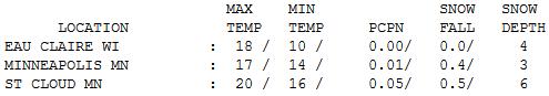
20 F. high on Wednesday in the Twin Cities.
24 F. average high for January 2.
20 F. high on January 2, 2012.
4/10ths of an inch of snow fell at KMSP International Airport yesterday.
3" snow on the ground (at least at the airport). Amounts vary around the metro area.
16.2" snow so far this winter in the Twin Cities.
22.6" average snowfall, as of January 2.
Winter Doldrums
"What a waste of cold air."
My friend, an avid snowmobiler, shook his fist
at the sky. I feel your pain. Last winter was a bust for snow lovers.
The hope and expectation was that this winter might be different, a
little closer to normal in the snowfall department. Wait, what happened
to normal?
Storms thrive on the boundaries separating warm,
moisture rich air bubbling out of the Gulf of Mexico - and fresh bursts
of bitter air swirling out of Canada. It's certainly been cold enough
for snow in recent weeks, but prevailing jet stream winds howling from
the west/northwest have forced the storm track too far south and east of
Minnesota for heavy snow close to home. It's still much too early to
write off winter snow, but the drought I've been talking about (ad
nauseum) is still a factor.
For the sake of farmers I'm hoping for a
real shift in the pattern.
Expect goosebumps today; highs stuck in the
teens, but at least the sun will be out. 20s will feel like sweet relief
by Friday. 30s are possible much of next week; even a little rain next
Thursday.
Some models are hinting at the coldest air of winter by the 3rd week of January.
No, this winter won't be as easy as last. But I
still think we'll wind up with a winter slightly warmer than average.
Stay tuned...
* image above: andfunforall.blogspot.com.
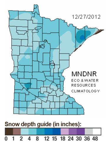
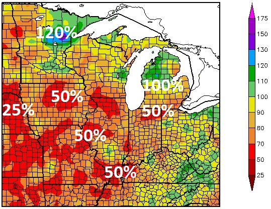
Spotty Snowcover. Parts of the
Minnesota Arrowhead have as much as 12-15" of snow (lake effect
enhanced) but most of the state is enjoying (?) anywhere from 2-5" of
snow, about half the amount of snow that should be on the ground in
early January. Map:
Minnesota DNR.
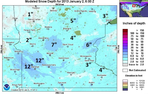
Another Perspective. Based on
NOAA guidance here is a higher-resolution look at where the most snow on
the ground is as of January 2: from Taylors Falls westward to Sauk
Rapids and Benson. The Marshall area has as much as 8-12" of snow on the
ground, while the Red River Valley has less than 1-2" to report. Very
odd.
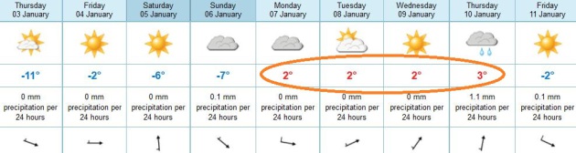
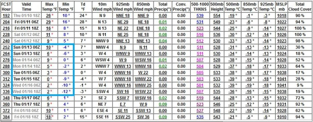
January Thaw Next Week? It's not definite (it never
is), but the ECMWF model is fairly consistent pulling Pacific air into
Minnesota next week, perhaps 3 or 4 days with highs near or just above
freezing. Today should be the coldest day of the next 8. Note the chance
of light rain next Thursday, the brunt of the moisture from next week's
storm sliding south and east of Minnesota. Nothing new there.
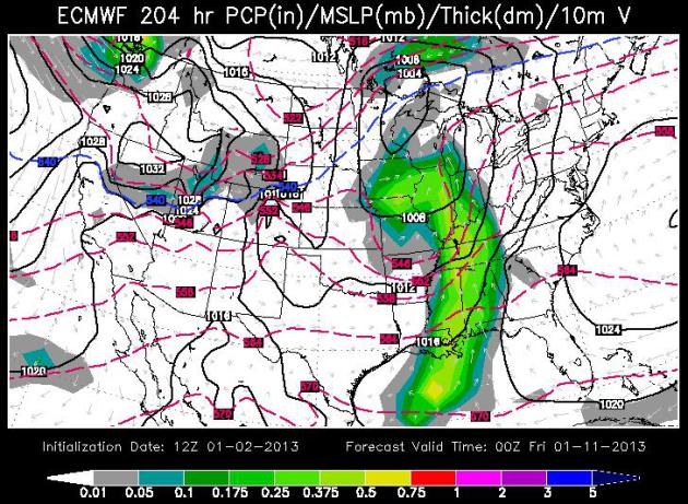
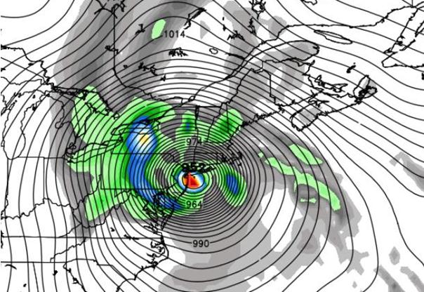
Another Close Encounter Late Next Week. The European
model outlook above (courtesy of WSI) shows a storm winding up over
eastern Iowa by Thursday evening; the atmosphere warm enough for rain
from Chicago and Des Moines on south. A little unusual for mid-January,
yes.
Mid-Month Reality Check. The GFS is (consistently)
pulling much colder air into town starting next weekend, the second
weekend of January, with a few cold days in the middle of the month,
maybe 2-3 nights below zero. Not record-setting chill, but cold enough.
Climate Summary For 2012. Here is a good recap of
2012, a year that tied 1931 for the warmest year in Twin Cities recorded
history. Details from the local
Twin Cities NWS office: "
2012
was an extremely warm year across the Upper Midwest. It tied for the
warmest year on record at the Twin Cities, MN. St. Cloud, MN saw its 2nd
warmest year on record, and Eau Claire, WI experienced its 3rd warmest
year in recorded history. It was a dry year as a whole across much of
the Midwest, but parts of Minnesota ended the year with near to slightly
above normal precipitation amounts, primarily due to a very wet period
from late spring into early summer. The Cooling Degree Days and Heating
Degree Days Departuren From Normal charts really shows how warm the cold
season was for the latter portion of the 2011-2012 winter, and the
beginning of the 2012-2013 winter. There were even Cooling Degree Days
recorded in March of 2012, which was the warmest March on record for
most of the area, including the Twin Cities, St. Cloud and Eau Claire."
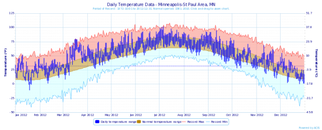
* the blue line above shows the actual temperatures, day by day, for
the Twin Cities in 2012. Note the lack of any record lows (light blue
line at the bottom of the curve) - temperatures much of the year well
above the average band (brown) near the middle of the curve. Graphic
courtesy of NOAA.
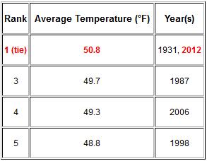
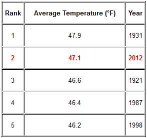
Warmest Years. The graphic above (courtesy of the
Twin Cities NWS) shows 2012 in a tie with 1931 for the warmest year on
record for the Twin Cities. 4 of the 5 warmest years on record have
occurred since 1987.
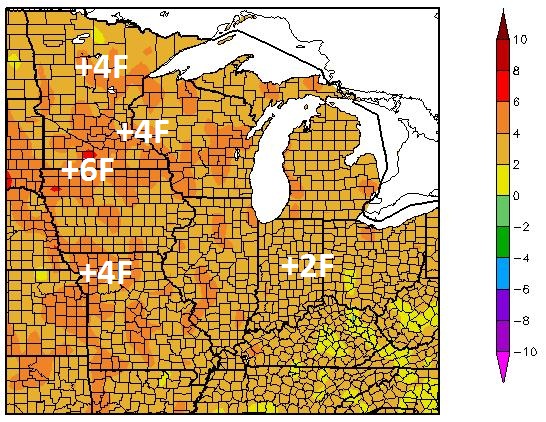
2012 Temperature Departures. Most of the Upper
Midwest, Great Lakes and Ohio Valley experienced 2012 temperatures 2-5
F. above average, as much as 6 F. warmer than normal for parts of
southwestern Minnesota, northwest Iowa and South Dakota. Graphic
courtesy of the
Twin Cities NWS.
2012 Precipitation Departures. Here's another good recap of 2012, courtesy of the
Twin Cities NWS.
Rainfall was well above average near Duluth, the result of a 1-in-500
flood in late June that dumped as much as 10" of rain in less than 36
hours. Far western Minnesota, and much of Wisconsin saw rainfall amounts
50-80% of normal, less than 25% normal rainfall reported west of Omaha
and Sioux Falls.
2012: Second Warmest Year On Record For St. Cloud. NWS data shows that St. Cloud missed the record by .8 F. 3 of the 5 warmest years have been observed since 1987.
Subzero Stats. Tuesday morning's low of -6 at MSP was the first below zero there since January 21, 2012.
This 345 day stretch between days with below zero lows was the 2nd longest such stretch of all time, trailing only a 348 day stretch that came to an end December 21, 1878. Source: Twin Cities National Weather Service.
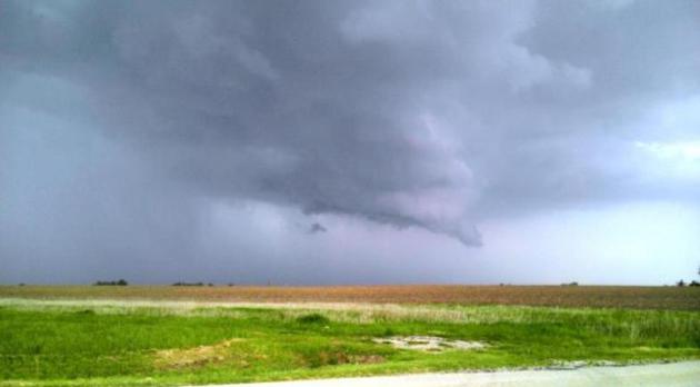
2012 USA Severe Storm Statistics:
699 Severe Weather Watches Issued Tornado and Severe Thunderstorm
1066 Tornado Reports – Actuals still being tallied, but through September 839 Actual Tornadoes.
7022 Damaging Hail Reports 3/4″ or Larger
14,043 Damaging Wind Events 57 MPH or Higher
Texas received the most reports, while Hawaii and Alaska tied for the least.
3/02/12 was the most Tornadic day, with 132 reports of Tornadoes.
7/01/12 was the most Severe day, with 737 Reports.
* data courtesy of
Weather HQ. Wall cloud photo above: NOAA.
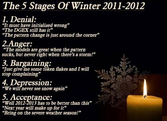
In (Snowy) Denial. The lack of snow (except for that
one nice, big burst of snow on December 8-9) reminds me a little of
last winter, when we were all making up excuses. Here's a graphic I
saved from last winter. I haven't written off winter (snow) just yet,
but just looking at the trends and nagging drought I suspect getting a
series of major snow storms will be the equivalent of swimming upstream.
For the sake of snow lovers (and farmers who need moisture on their
fields) I hope I'm wrong.
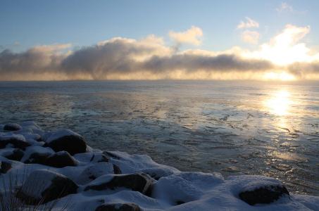
The Genesis Of "Lake Effect". You can almost see
those clouds bubbling and boiling over the (relatively) warmer waters of
Lake Superior near Bayfield, Wisconsin. Subzero air passing over open
water with water temperatures in the 30s has resulted in heavy snow
squalls downwind, over Wisconsin and the U.P. of Michigan. Photo
courtesy of Migizi Gichigumi.
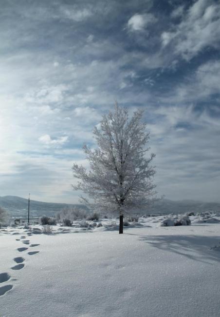
Winter Serenity. Thanks to the Elko office of the National Weather Service for passing this one along. Very nice...
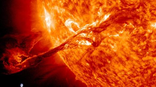
The Best NASA Images From 2012. Gizmag.com has details, and links to some amazing photographs; here's an excerpt: "
2012 saw a number of significant milestones in star gazing and space exploration. NASA's Mars rover Curiosity touched down on the Red Planet in spectacular fashion, super-Earth's were discovered, the Moon pounded and Voyager 1 edged ever closer towards interstellar space and we saw more of the universe around us than ever before..."
Photo credit above: "
August 31, 2012: A solar filament erupts out into space." (Image: NASA/GSFC/SDO)
A Computerized Fishing Rod? Sure - Why Not? This is what I need to (finally) catch trophy fish. A computerized rod and reel; details via
gizmag.com: "
Imagine
that you’re an angler who has several lines in the water at once. How
will you know if a fish strikes on one of your unmanned rods? Well, you
could attach a bell to each rod, or just listen for its reel to start
running. In these days of electronic everything, however, another
alternative is now in the works – the computerized POLETAP SMARTROD.
The water-resistant rod is the creation of Kansas-based inventor Ed
Hope. It works with any reel, and contains an accelerometer that detects
the telltale jerk of a fish taking the lure..."
Photo credit above: "
The POLETAP SMARTROD uses a built-in accelerometer to detect fish strikes."
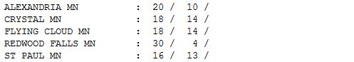
Cosmetic Snow. It was just enough snow to cover up
some of the grit, and ice up roads a bit. Half an inch fell at St.
Cloud, with 6" on the ground.
Paul's Conservation Minnesota Outlook for the Twin Cities and all of Minnesota:
TODAY: Cold sun. Feels like January. Winds: W 10. High: 14 (wind chill dips below zero at times).
THURSDAY NIGHT: Mostly clear and cold. Low: 9
FRIDAY: Blue sky. Minnesota "warm front". High: 29
SATURDAY: Partly sunny, closer to average. Low: 14. High: 24
SUNDAY: More clouds than sun, brisk. Low: 11. High: 22
MONDAY: Intervals of sun, thawing out a bit. Low: 17. High: near 30
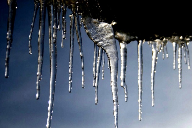
TUESDAY: Welcome January Thaw. Low: 19. High: 33
WEDNESDAY: Dripping icicles? Midwinter Pause. Low: 21. High: 34
* a little rain or rain/snow mix is possible next Thursday.
Climate Stories....
After Hurricane Sandy, Climate Change Is Back On The Political Agenda. Here's a reprint of an article from From
New America Media and
InsideClimate at
highbrowmagazine.com: "
This
was the year climate change vanished from the political agenda—and
then suddenly reappeared, after Hurricane Sandy shook the country. It
was just a few years ago that President Obama flew to Copenhagen to
rescue faltering climate-treaty talks amid bipartisan calls for global
warming action. But in 2012, there wasn't a single congressional
proposal or hearing on climate legislation. Neither was there mention of
climate change on the presidential campaign trail, or in the debates
for the first time in decades. In the rare instances that climate change
surfaced in national discussions, politicians were fixated on the one
aspect of warming scientists aren't debating: whether it's occurring.
Republican-affiliated climate researchers told InsideClimate News that
attempts to educate their party leaders on the science were rebuffed.
Meanwhile, many U.S. scientists fended off attacks of global warming
skeptics, while Canadian scientists had to deal with budget cuts and
muzzling by their government..."
Chevron Chief Dismisses Climate Change Concerns. Here's a snippet of a story from The Washington Post and RTCC,
Responding To Climate Change: "
In an interview with news agency AP published in the Washington Post, Watson argues oil, gas and coal are the only “affordable” sources of energy available to governments. Reports from the World Bank and accountants PwC published in November 2012 warned that the world is on a trajectory to warm 4-6°C
by 2100, which scientists say would lead to catastrophic changes in the
global climate, together with rising sea levels. But Watson, whose
company is planning to invest $33 billion in oil and gas exploration
this year, says efforts to take direct action to address climate
change, such as putting a tax on carbon, are inappropriate as they will
put pressure on energy process and the world economy..."
Photo credit above: "
Chevron CEO John Watson: The company
is the second largest investor-owned oil and gas business in the world,
reportedly making a $24 billion profit in 2012."
Climate Disruption: Critical 2012 Events And Stories. Here's an excerpt of a story at
Huffington Post:
What were the most notable climate-related stories of the year?
"
A group led by Greg Laden,
interested in climate science, put together a list of notable, often,
most worrying, climate-related stories of the year, along with a few
links that will allow you to explore the stories in more detail. While
it started, perhaps innocently, as a quest for a 'top ten' list, the
effort to fit within an arbitrary limit quickly fell by the wayside.
Thus, we did not try to make this a "top ten" list, because it is rather
silly to fit the news, or the science, or the stuff the Earth does in a
given year into an arbitrary number of events. (What if we had 12
fingers, and "10" was equal to 6+6? Then there would always be 12
things, not 10, on everyone's list. Makes no sense.) We ended up with 18
items, but note that some of these things are related to each other in
a way that would allow us to lump them or split them in different
ways. (See this post by Joe Romm for a more integrated approach to the year's events..."


No comments:
Post a Comment