-5 F. low temperature Tuesday morning in the Twin Cities.
14 F. high temperature yesterday at KMSP.
24 F. average high for January 1.
34 F. high on January 1, 2011.
Freezing by Friday afternoon? Expect 2-4 days at or above freezing next week.
Cold Weather Tax
"Winter is not a season, it's an occupation" wrote Sinclair Lewis.
Perhaps, although I consider winter a
well-disguised Godsend. Think about it. If it didn't get cold every now
and then, a couple of battery-draining nights, our population would
spike. Those wide-eyed CNN meteorologists pointing to Minnesota
unwittingly keep our commutes less horrific; nice cabins on our lakes,
instead of high rise condos.
Then again I may be rationalizing the lack of feeling in my toes.
We're picking up 1-2 minutes of additional
daylight every day now. Within 3-4 weeks average temperatures start to
rise again. I have a hunch our current cold spell will be one of the 2
or 3 coldest of winter. Models show highs near 32F by Friday; a few days
in the 30s next week.
Snow? A dusting or coating of flurries today; by
the end of next week it may be mild enough aloft for a little rain. The
drought that developed in late summer continues to flavor our weather;
El Nino nudging the storm track south/east of Minnesota.
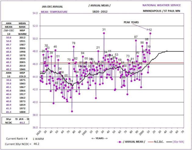
On the blog below: 2012 was second only to 1931
for the warmest year in Twin Cities history. Our 5 warmest years have
all occurred since 1987.
My gut? Another abbreviated, drive-by winter is shaping up.
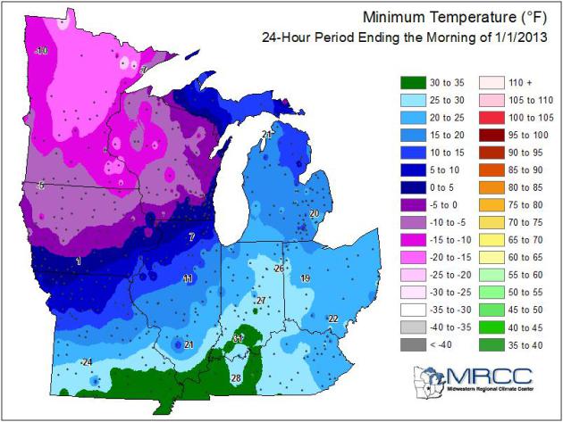
A Numbing New Year. Tuesday morning saw the coldest
readings of the winter, so far, subzero statewide, as cold as -21F (air
temperature) at Paynesville. Details from the Midwestern Regional
Climate Center, via the
Twin Cities NWS.
A "Warming Trend". Few other spots on Earth (outside
of interior Alaska, portions of Finland and Siberia) would call 0 to +3
C a "warm front", but after negative numbers I can assure you that 30s
will feel good, as early as Friday. Significant snow? You 'gotta be
kidding me. No.
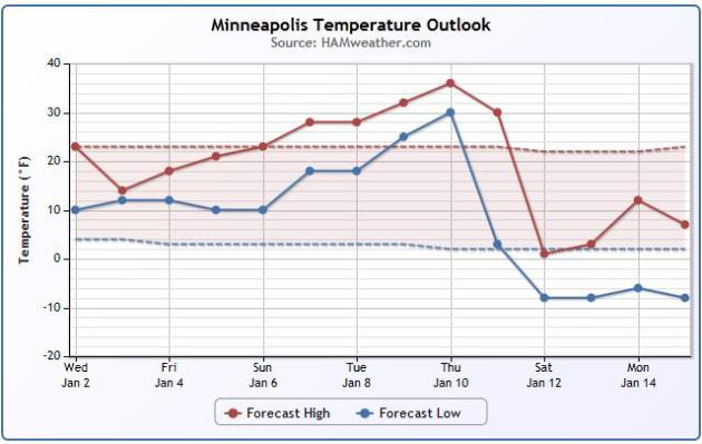
Temperature Trends. This Ham Weather graphic makes
it easy to see the average high and low for the period, and predicted
temperatures looking out into mid-January. After warming into the 30s
much of next week readings take another dive by the second weekend of
January.
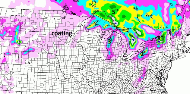
Predicted Snowfall Thru Friday Night. The latest NAM
numbers look pretty bleak (for snow lovers). Lake effect snow squalls
may drop up to 8" near Syracuse, but - note to self - we don't live in
Syracuse. Can I interest you in a snowy coating today? Bleak.
Warmest Year Since 1820? 1931, By A Whisker. You have to go back to the beginning of the Dust Bowl years to find a warmer year, overall, than 2012, according to
Twin Cities NWS data.
I think we can all agree that, in spite of a cold finish, last year was
unseasonably warm. Note the warming trend since the mid-80s above
(solid black line).
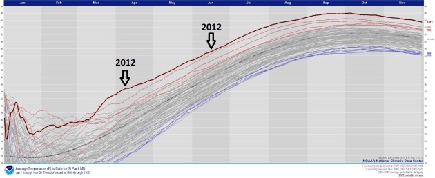
2012: "Off The Scale". The dark red line shows St.
Paul temperature trends in 2012, well above the previous 4 warmest years
in modern-day records (1987, 1998, 2006 and 2010). For a better look at
this graph from NOAA NCDC
click here.
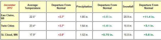
December Numbers. Statewide December was warmer, and a bit snowier than normal (most of the snow coming during the December 9 storm). The
local National Weather Service has a good summary: "
December
of 2012 brought something the area hardly saw at all during the
2011-2012 winter and that is snowfall. The majority of snow seen during
the month was observed with the December 8th and 9th snowstorm, though
Eau Claire did get some snow from the December 20th blizzard that
struuck Iowa into southern Wisconsin, helping give Eau Claire the most
snowfall for the month between the 3 climate locations. Add into the mix
a primarily rain event the following weekend and the entire area got to
experience something for the first time since this summer: above normal
precipitation for a month. Of course in a year when all three locations
were at or within a degree of setting the record for the warmest year
on record, it shold come as no surprise that yet again, temperatures for
te month of December were above normal. In all, only October saw below
normal temperatures for a month in 2012, with all other months seeing
above normal temperatures at St. Cloud and MSP (Eau Claire snuck in a
below normal month in September as well)."
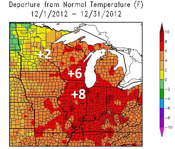
Shocker: Another Warmer Than Average Month. The
Midwestern Regional Climate Center
shows temperature anomalies for December 2012 ranging from +2 to +5 F.
across much of Minnesota, as much as 8-10 F. warmer than average from
Chicago into much of the Ohio Valley.
Increasing Daylight. We're picking up 1-2 minutes of
daylight every day from later this week into mid-January. Historically
the coldest weather of the year comes during the second or third week of
January, about 3 weeks after the Winter Solstice. Calendar source
here.
Top 10 U.S. Weather Events Of 2012. The more I read
about Superstorm Sandy, the more impressed I am by the size and
intensity of this historic storm. Here's a post from Wunderground
meteorologist Jeff Masters, via
Think Progress: "
It
was another year of incredible weather extremes unparalleled in
American history during 2012. Eleven billion-dollar weather disasters
hit the U.S., a figure exceeded only by the fourteen such disasters
during the equally insane weather year of 2011. I present for you now
the top ten weather stories of 2012, chosen for their meteorological
significance and human and economic impact....
1) Superstorm Sandy
Hurricane Sandy
was truly astounding in its size and power. At its peak size, twenty
hours before landfall, Sandy had tropical storm-force winds that
covered an area nearly one-fifth the area of the contiguous United
States. Sandy’s area of ocean with twelve-foot seas peaked at 1.4
million square miles–nearly one-half the area of the contiguous United
States, or 1% of Earth’s total ocean area. Most incredibly, ten hours
before landfall (9:30 am EDT October 29), the total energy of Sandy’s
winds of tropical storm-force and higher peaked at 329 terajoules–the
highest value for any Atlantic hurricane since at least 1969, and
equivalent to five Hiroshima-sized atomic bombs. At landfall,
Sandy’s tropical storm-force winds spanned 943 miles of the the U.S.
coast. No hurricane on record has been large..."
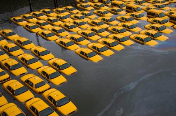
Photo credit above: "
Cabs lie flooded on October 30, 2012, in Hoboken, NJ, in the wake of Hurricane Sandy." AP photo: Charles Sykes.
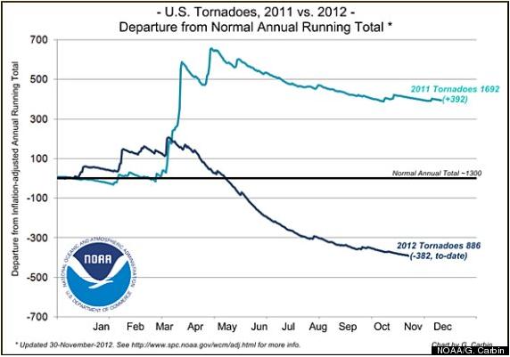
2012 Tornado Count Could Be One Of The Lowest In History.
The reason? Record heat (and drought) over much of the USA for much of
the summer, none of the large temperature contrasts that whip up strong
wind shear, capable of turning garden-variety thunderstorms into
tornadic "supercells".
Huffington Post has more details: "...
Harold
Brooks, research meteorologist at NOAA's National Severe Storms
Laboratory in Norman, Okla., said that the lack of wind shear is
responsible for the lower number of tornadoes in 2012. "That's
associated, in some ways, with the drought that was over the central
part of the U.S. during the summertime," Brooks said. "The jet stream
went far to the north, and when we have that kind of a pattern over the
central U.S., you have very hot weather at the surface. When it is
that hot and dry, you don't get very many storms. And the storms that
do form, there is not enough wind shear to get them organized into the
kind of storms that make significant tornadoes." With very quiet and dry
weather patterns, the winds do not vary much in speed or direction
with height. Thus, rotating thunderstorms capable of producing
tornadoes are less likely..."
Graphic credit above: NOAA SPC.
"This graph from the SPC
shows the number of tornadoes in 2012 compared to the number of
tornadoes in 2011 and the average number of tornadoes annually in the
U.S."
Study: Home Air Conditioning Reduced Deaths. This
probably doesn't come as a shock, but there is something of a paradox
here: A/C requires electricity, which requires burning of fossil fuels,
which warms the air, increasing the need for more air conditioning. Not
sure how we (easily) break this cycle. Here's an excerpt of an article
from
courier-journal.com: "
The
installation of air conditioning in American homes reduced the
chances of dying on an extremely hot day by 80 percent over the past
half-century, according to an analysis by a team of American
researchers.The findings, based on an analysis of U.S. mortality
records dating back to 1900, suggest the spread of air conditioning in
the developing world could play a major role in preventing future
heat-related deaths linked to climate change. Very few U.S. homes had
air conditioning before 1960; by 2004, that figure had climbed to 85
percent..." (Photo: NOAA).
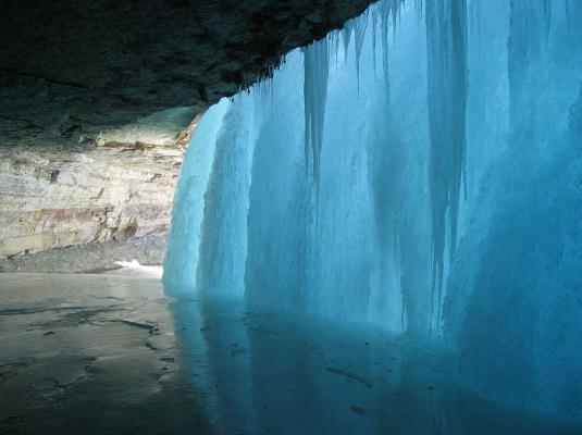
Minnehaha Falls, Like You've Never Seen It Before. This is one of the benefits (?) of a cold wave, one of the more remarkable photos I've seen recently. Details from
Neatorama: "
Minneapolis-based
photographer Matt Sepeta captured this image of the frozen Minnehaha
Falls. Located in a Minneapolis park, Minnehaha Falls are near the
point where the Mississippi River and Minnehaha Creek converge."
Forecasts For The Year Ahead, From Apps To Zebra Mussels. Here's a clip from a particularly interesting look ahead at 2013 from journalists at
The Star Tribune: "...
As
2013 wakes us with a brisk and bracing start, some predictions for the
year ahead are crystal clear. Many Minnesotans will escape to Hawaii,
but they'll also worry about invaders in our home waters. We'll need
more health care, and the system will dramatically change. Job gains
may slow, but those driving to work could pay more. A new Vikings
stadium will start to rise up, and technology will infuse our lives
even more, impossible as that seems. We asked experts in the Twin Cities
and beyond to peer ahead into the changes we face this year -- for
better or for worse..."
The Top 5 Tech Start-Up Trends of 2013. Here's an excerpt of a
Wall Street Journal that caught my eye: "
1. Our phones are becoming our remote controls for life.
If we have a need for it in our daily lives, there should and will be
an icon and app for it on our phone. It’s as simple as that. Our phones
are our emergency kit for first-world problems. Whether it’s a taxi or a ride in the rain (Uber, Lyft), a mechanic (YourMechanic), a doctor’s appointment (ZocDoc), the literal remote control (AppleTV), a personal assistant (Exec), a cake-baker (Zaarly), groceries (Instacart), or you’re getting a little chilly and want the temperature in the house turned up (Nest),
our phones are the concierge. I expect this phenomenon to continue in
2013 and as we run into times in our daily lives when we don’t have an
icon for it just yet. Someone will be working hard to create it..."
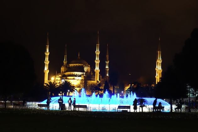
"The Blue Mosque". Istanbul was
amazing - we there for 4 days in late December. Every December we try to
explore a city we haven't been to before (and rack up a few more Delta
MQM Skymiles). It's a long trek getting there, but definitely worth the
effort. The locals couldn't have been any friendlier.
A Bieber Christmas. This year all my Christmas gifts came in Justin Bieber wrapping paper. I'm scared to open them...
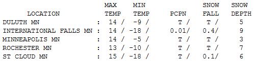
New Year's Day Numbers. Yes, it was
cold out there - readings about 10 degrees colder than average. After
waking up to subzero readings (and sunshine) clouds increased, leaking a
few flurries; highs ranging from 11 at Hibbing to 14 Twin Cities, 15
St. Cloud and 23 at Grand Marais.
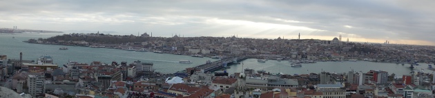
Istanbul From The Galata Tower.
That's the Old City below, a remarkable metropolitan area that dates
back thousands of years. Temperatures were in the 50s - I wasn't
complaining about the weather.
Paul's Conservation Minnesota Outlook for the Twin Cities and all of Minnesota
TODAY: Coating of flurries, a few slick spots. Winds: SW 10. High: 22
WEDNESDAY NIGHT: Flurries taper, turning colder. Low: 10
THURSDAY: Sunny and colder again. High: 14
FRIDAY: Sunny. Grilling weather! Low: 8. High: 31
SATURDAY: More clouds, cooler breeze. Low: 14. High: 25
SUNDAY: Some sun, not quite as chilly. Low: 12. High: 28
MONDAY: Intervals of sun, risk of a thaw. Low: 18. High: 33
TUESDAY: Sunny peeks. Above average temperatures. Low: 20. High: 32
Climate Stories...
Top Climate Stories of 2012. Here's a look at a Greg Laden post at
scienceblogs.com: "
A
group of us, all interested in climate science, put together a list of
the most notable, often, most worrying, climate-related stories of the
year, along with a few links that will allow you to explore the stories
in more detail. We did not try to make this a “top ten” list, because
it is rather silly to fit the news, or the science, or the stuff the
Earth does in a given year into an arbitrary number of events...."
1 Super Storm Sandy
"
Super Storm Sandy, a hybrid of Hurricane Sandy (and very much a
true hurricane up to and beyond its landfall in the Greater New
York/New Jersey area) was an important event for several reasons.
First, the size and strength of the storm bore the hallmarks of global
warming enhancement. Second, its very unusual trajectory was caused by a
climatic configuration that was almost certainly the result of global
warming. The storm would likely not have been as big and powerful as it
was, nor would it have likely struck land where it did were it not for
the extra greenhouse gasses released by humans over the last century
and a half or so...."
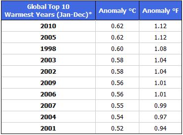
Top 10 Warmest Global Temperatures. Here are more details from
Global Warming: Man or Myth?:
"20
of the warmest years on record have occurred in the past 25 years.
The warmest years globally are 2005 with the years 2009, 2007, 2006,
2003, 2002, and 1998 all tied for 2nd within statistical certainty.
(Hansen et al., 2010) The warmest decade has been the 2000s, and each
of the past three decades has been warmer than the decade before and
each set records at their end. The odds of this being a natural occurrence are estimated to be one in a billion! (Schmidt and Wolfe, 2009)."
Will The West Survive? Just looking at the trends -
it's going to become even more challenging living in water-challenged
western cities from Denver to Las Vegas and Phoenix, even Los Angeles.
Here's an excerpt of an eye-opening article at
Men's Journal: "
This
year, summer came on like a grudge, with record-breaking heat,
inescapable drought, and the sense that the effects of climate change
had arrived – and that life in America's mythic frontier might never be
the same. Something looked off when I landed at Denver International
Airport this past August. It had been about four years since my last
visit, and I couldn't immediately put my finger on what was up. I
bought a coffee, glanced at the 'Denver Post,' and wandered out into
the main terminal, with its silly bedouin design, the domed white
ceiling looking as flimsy and tarplike as ever. It wasn't until I was
outside, riding in the shuttle bus to my rental car, that it struck me
what had changed: The Rocky Mountains had vanished..."
The Windowless Room Of The Current Event. One
problem many people have with MSM (mainstream media) is a collective
amnesia, an inability to connect the dots and look at the big picture.
Not what it is, but what it MEANS. Bill Moyer's web site takes a look at
the media's inability to see the bigger picture with climate change in
this post; here's an excerpt: "...
Or
take quite a different subject: climate change. These days — despite
the 2012 presidential campaign’s silence on the subject until
Frankenstorm Sandy hit — “extreme weather,” as the TV news generally
likes to call it, is regularly headlined. Increasingly often, there is
at least passing mention of, or even discussion of, climate change in
some of these stories. Again, though, what’s generally striking in
mainstream reportage is the way the dots aren’t connected. The issue is
less what isn’t reported, than what isn’t included. After all, this
year in American weather has been extraordinary. A partial list of the
most salient events would include: the parching of the Southwest, as
well as record wildfires, sometimes of staggering proportions in New Mexico, Texas, Colorado and across the West; the heat records that made 2012 an “endless summer” and is just about sure to make it the hottest year
in the continental U.S. since records began being kept; the
devastating drought across the Midwestern bread (or corn) basket and
parts of the South, which for many months had 60-65 percent of the country in its grip (and shows no sign of going away this winter) — with damage running into the many tens of billions of dollars;
and, of course, the way Sandy, that gigantic storm passing over the
heated waters of the Atlantic, surged into New York City and ravaged the
New Jersey coast, causing widespread devastation and tens of billions of dollars in damage (while putting climate change back onto the political map)...."
Global Warming Research Eyes "Runaway" Ice Melt. Here's an excerpt from
The Summit County Citizens Voice: "
Most
climate models are probably underestimating the rate of sea level rise
expected during the next few decades, according to some of the latest
research that tries to quantify how much ice may melt off the Greenland
and Antarctica ice sheets. A Dec. 26 update
by James Hansen and Makiko Sato warns that melting of those ice sheets
could increase sea level rise exponentially higher than most existing
forecasts, potentially inundating coastal cities around the world with
several feet of water by the end of the century. The short paper
discusses the linearity assumptions in most existing climate models
and suggests that, if greenhouse gas emissions continue unchecked, “the
climate forcing will be so large that non-linear ice sheet
disintegration should be expected and multi- meter sea level rise not
only possible but likely.”..."
Photo credit above: "
Will there be runaway ice sheet melting?" Bob Berwyn photo.


No comments:
Post a Comment