35 F. high in the Twin Cities Wednesday.
23 F. average high for January 9.
49 F. high on January 9, 2011.
3" snow on the ground. With rain and highs near 40 today and tomorrow that may shrink to 1" by Friday evening.
-5 to -10 F. wind chills expected Saturday night into Sunday.
January Puddles
There are January Thaws, and then there are
January Meltdowns. A year ago today the high in the Twin Cities was a
balmy 52 F. January of 2012 saw 9 days above 40; an average monthly
temperature 7.7 F. above average, setting the tone for a warm year to
come.
3 months ago I went out on a limb and predicted
this winter wouldn't be as mild as last winter - and not as snowy as
2010-2011 either. Something in-between those two (extreme) winters. I
stand by that forecast, by the way.
A little rain is likely tonight & Friday.
Highs top 40 F. tomorrow before falling off a temperature cliff on
Saturday; a howling northwest wind making it feel subzero by afternoon.
Big swings.
We get off to a numbing start next week, but I'm
no longer convinced it'll be the coldest week of winter. Right now it
looks like a glancing blow of frigid air; a couple more subzero nights
late next week. We may still get smacked by hair-curling cold again in
late January, but the risk of sustained, day after day of soul-grinding
cold has lessened a bit.
NOAA predicts some slight improvement in the
drought over eastern Minnesota, but "persistence" across much of
Minnesota, meaning more of the same.
I hope we're not still having this (drought) conversation come April.
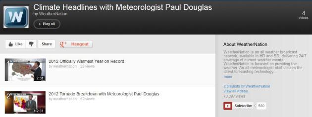
11 Separate Billion Dollar Weather/Climate Disasters In 2012. Here's the latest installment of my (daily) climate headlines, available at
YouTube: "
Meteorologist
Paul Douglas takes looks at the billion dollar extreme weather events
of 2012. There are 11 events in total including Hurricane Sandy,
Hurricane Isaac, the Derecho and the Drought. What do you remember
most about the weather in 2012?"
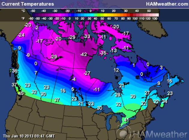
Seriously Cold. These were air
temperatures yesterday evening over Canada. It now appears the core of
this pipe-rupturing, battery-draining air will merely brush the Upper
Midwest and Great Lakes early next week, a second surge coming the end
of next week. But the very coldest air is forecast to stay north of the
border for the next 1-2 weeks. For the current temperatures over Canada
click here, maps courtesy of Ham Weather.
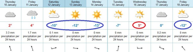
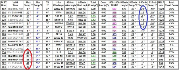
Temperature Roller Coaster.
After upper 30s to near 40 today and Friday temperatures plummet
Saturday, highs close to +10 F. Sunday and Monday with a subzero
windchill. The next clipper yanks milder air northward, a brief thaw
possible next Wednesday, before a second surge of cold air arrives the
end of next week. Cold, but not quite brutally cold. ECMWF forecast
highs above in Celsius.
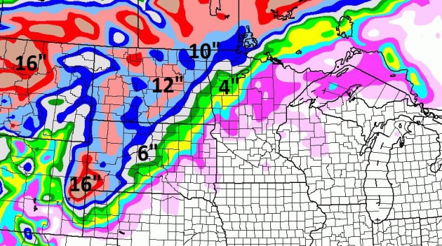
84 Hour Snowfall Forecast.
Looking for fresh snow? Drive west, about 5-6 hours or more. The
Dakotas will pick up enough snow to shovel and plow, maybe a foot or
more from the Black Hills to Bismarck, maybe 3-6" for the Red River
Valley of far northwestern Minnesota.
Night And Day.
Yesterday I showed you a 16-day GFS outlook that looked like the early
stages of the Next Ice Age. Today's run looks (very) different. Yes, it
will get cold over the weekend, another push of chilly air the end of
next week. But the latest long-range models are hinting at a thaw
between January 23-25. The models are more erratic than usual, but at
least for the next 2 weeks it now appears that the core of the coldest
air will stay just north of Minnesota.
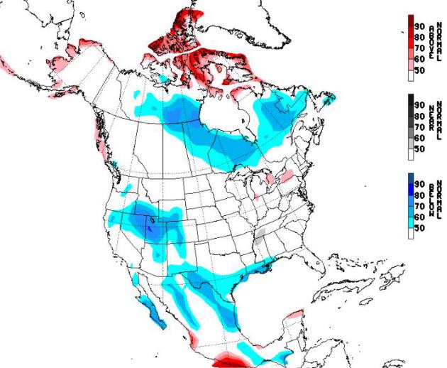
NAEFS Extended Outlook.
Experimental long-range guidance from NOAA's NAEFS model keeps the
worst of the cold wave near Hudson Bay. Confidence level: exceedingly
low. Check back in tomorrow to see if the models have flip-flopped again
ok?
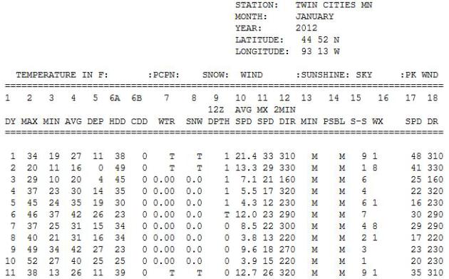
"March-uary": January 2012. Remember last year at
this time? Freakishly warm, in fact a year ago today it was 52 F. in the
Twin Cities. We saw 9 days of 40-degree or warmer temperatures late
January, setting the stage for the warmest year in Minnesota history.
Check out the January 2012 data from the
Minnesota Climatology Working Group.
From A Star Tribune Reader:
Hi Paul,
I live in Inver Grove Heights and Robins are here already. This is the earliest I've seen them that I can recall.
What is your take on this?
Best regards,
Jerry Wussow
Jerry
- those are brave robins, that's all I can say. By Saturday they will
probably regret their decision to stay (or migrate) to Inver Grove
Heights. I suspect it's a fluke - I can't say I see any sign (yet) of an
early spring, nothing like what we experienced last "winter". Thanks
for passing this along.
Climate Headlines. Here's
one YouTube link
that has all the 2:30 climate headlines I'm creating for WeatherNation
TV and our other media partners - a chronological list of segments
highlighting some of the biggest weather and climate stories that made
me do a double-take.
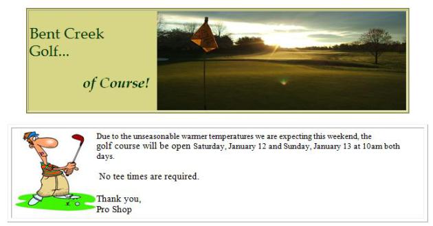
January Golf? My father lives in Lancaster county,
Pennsylvania, about 80-90 minutes west of Philadelphia. With
unseasonable warmth in the forecast the local golf course has decided to
open up next weekend. No tee times are required. Sounds like a good
plan to me.
2012: Hottest Year Ever In U.S. Thanks Onion - I needed this chuckle. If you need a (PG-rated) day--brightener
click here.
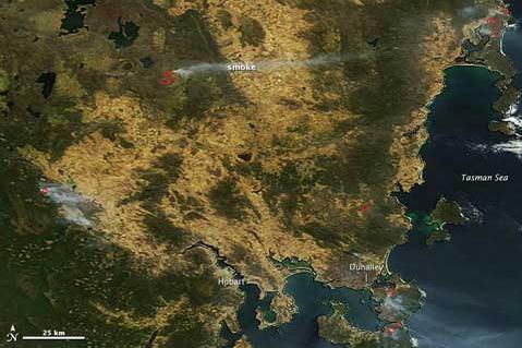
Too Hot: Australia's Big Heat-Breaking Records. Here's an excerpt of a story on the historic levels of heat gripping Australia from New Zealand's
Hot Topic: "...
NASA’s Earth Observatory provides this overview
of the fires in Tasmania over the weekend that caused chaos and
destruction in the normally cool state — Hobart hit an all time high
temperature of 41.8ºC, a full degree above its previous record. Fire
danger in parts of New South Wales has been classified as catastrophic,
and this NASA Worldview image for Jan 8th appears to show smoke from fires in southern NSW streaming out to the east and over the sea towards New Zealand..."
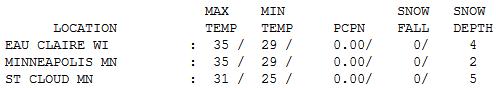
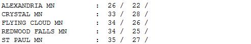 A Runny Landscape
.
Yesterday was the 3rd day of the January Thaw, with temperatures 10-15
F. warmer than average. Afternoon highs ranged from 26 at Alexandria to
31 St. Cloud (down to 5" snow on the ground)
to 35 in the Twin Cities and Eau Claire.
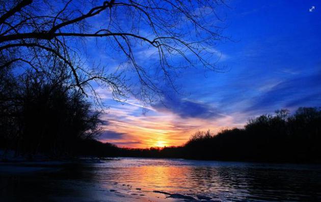
Sunset To Remember. Thanks to
Tom Purdy, who snapped this terrific photo of the Rock River, near Janesville, Wisconsin late Tuesday.
Paul's Conservation Minnesota Outlook for the Twin Cities and all of Minnesota:
TODAY: Clouds increase. Light rain late. Winds: S 10-15. High: 38
THURSDAY NIGHT: Cloudy and foggy with periods of rain. Low: 34
FRIDAY: Gray and foggy with light rain and drizzle. High: 41
SATURDAY: Few flakes. Windy, much colder - feels like 0 to -5 by afternoon. High: 18 (falling sharply during the day).
SUNDAY: Partly sunny, brisk. Wind chill: -5 to -10. Ouch. Low: 3. High: 11
MONDAY: Bright sun, still numbing. Low: 0. High: 10
TUESDAY: Dim sun, not as cold. Low: 10. High: 24
WEDNESDAY: Next clipper. Clouds, windy - snow probably stays north. Low: 20. High: 32
* Another shot of numbing air is likely the end of next week; probably not record-setting, but temperatures well below average.
Climate Stories...
"There are two ways to be fooled. One is to believe what isn't true; the other is to refuse to believe what is true".
- Soren Kierkegaard (1813-1855)
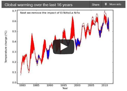
16 (More) Years Of Global Warming. One of the
denialist memes going around now is "there hasn't been any warming since
1998." Really? The last 9 consecutive 12 month periods over the USA
"conus" have been the warmest ever observed. We've gone 28 years in a
row with global temperatures consistently warmer than the 20th century
average. If you strip away volcanic and solar activity, as well as
biases brought on by El Nino and El Nina, there is no scientific
evidence that the rate of global warming has slowed...or peaked...or
dropped. None.
Skeptical Science takes a look at the latest scientific conspiracy theory: "
Human greenhouse gas emissions have continued to warm the planet over the past 16 years. However, a persistent myth has emerged in the mainstream media challenging this. Denial of this fact may have been the favorite climate contrarian myth of 2012, first invented by David Rose at The Mail on Sunday with an assist from Georgia Tech's Judith Curry, both of whom later doubled-down on the myth after we debunkedit. Despite these repeated debunkings, the myth spread throughout the media in various opinioneditorials and stunts throughout 2012. The latest incarnations include this article at the Daily Mail, and a misleadingly headlined piece
at the Telegraph. As a simple illustration of where the myth goes
wrong, the following video clarifies how the interplay of natural and
human factors have affected the short-term temperature trends, and
demonstrates that underneath the short-term noise, the long-term
human-caused global warming trend remains as strong as ever..."
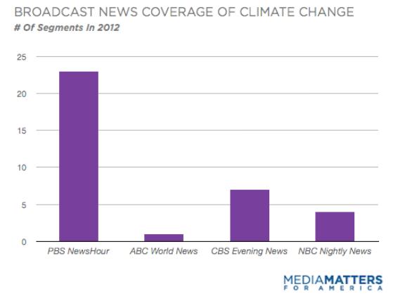
What Nightly News Shows Can Learn From PBS's Climate Coverage. Here's an excerpt of a report from
Media Matters: "
A Media Matters analysis found that the nightly news programs on ABC, CBS and NBC largely ignored climate change in 2012, despite record-breaking temperatures and a series of extremeweatherevents
in the U.S. By contrast, PBS NewsHour devoted almost twice as many
segments to climate change as the other networks combined. When the
National Climatic Data Center announced Tuesday that 2012 was the hottest year in recorded history for the contiguous U.S., broadcast networks admirably devotedsegmentsconnecting the announcement to climate change. But for most of the year they turned a blind eye to climate change, even while reporting on its consequences. Together,
the nightly news programs on ABC, CBS and NBC devoted only 12 segments
to climate change in 2012. PBS' coverage stood out, with its nightly
news program dedicating 23 segments to the issue..."
NASA Chases Climate Change Clues Into The Stratosphere. Here's a clip from a recent article from
NASA: "
Starting
this month, NASA will send a remotely piloted research aircraft as
high as 65,000 feet over the tropical Pacific Ocean to probe unexplored
regions of the upper atmosphere for answers to how a warming climate
is changing Earth. The first flights of the Airborne Tropical
Tropopause Experiment (ATTREX), a multi-year airborne science campaign
with a heavily instrumented Global Hawk aircraft, will take off from
and be operated by NASA's Dryden Flight Research Center at Edwards Air
Force Base in California. The Global Hawk is able to make 30-hour
flights. Water vapor and ozone in the stratosphere can have a large
impact on Earth's climate. The processes that drive the rise and fall
of these compounds, especially water vapor, are not well understood.
This limits scientists' ability to predict how these changes will
influence global climate in the future. ATTREX will study moisture and
chemical composition in the upper regions of the troposphere, the
lowest layer of Earth's atmosphere. The tropopause layer between the
troposphere and stratosphere, 8 miles to 11 miles above Earth's surface,
is the point where water vapor, ozone and other gases enter the
stratosphere...."
The Market And Mother Nature. Here's the intro to an Op-Ed in the
New York Times from St. Louis Park's Thomas Friedman: "
Whenever
I hear the word “cliff,” I am reminded of something that President
Obama’s science adviser, John Holdren, used to say about how we need to
respond to climate change because no one can predict when it might
take a disruptive, nonlinear turn. “We are driving toward a cliff in a
fog,” said Holdren about the climate, and that’s always a good time “to
start tapping on the brakes.” Indeed, when you think about how much
financial debt we’ve built up in the market and how much carbon debt
we’ve built up in the atmosphere, the wisest thing we could do as a
country today is to start tapping on the brakes by both emitting less
carbon to bend the emissions curve down and racking up less debt to bend
our debt-to-G.D.P. curve down. Unfortunately, we are still doing
neither..." (satellite image above: NASA).
Billion Dollar Weather/Climate Disasters In 2012. Here is a list of the most extreme weather and climate events in 2012, courtesy of
NOAA NCDC.


No comments:
Post a Comment