35 F. high in the Twin Cities Tuesday.
23 F. average high for January 8.
40 F. high on January 8, 2012.
2012: warmest year on record for the USA.
2012: second most extreme year on record for the USA.
Australia: experiencing the hottest weather on record. Details below.
2012: A Year Like No Other
Dripping icicles; rain Thursday night? That's weather.
Climate scientists step back and examine larger
global trends, analyzing data. Facts on the ground. NOAA now confirms
that 2012 was America's warmest year on record; 3.2 F. warmer than the
20th century average.
The Climate Extreme Index (CEI), a measure of
extremes in temperature & moisture, was second only to 1998, when we
saw the most extreme El Nino on record. More data points. Details on
the blog, along with news of historic heat in Australia. It's so hot
meteorologists are adding new colors on their weather maps.
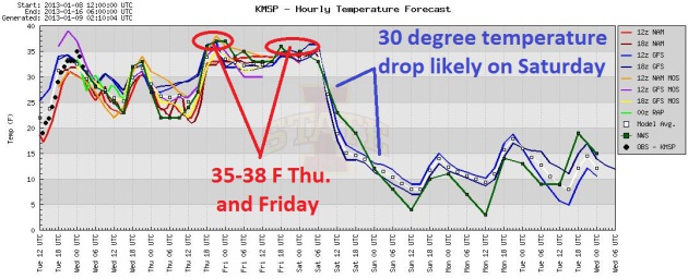
Savor a well-deserved January Thaw into Friday,
when highs may reach the upper 30s. The atmosphere will be warm enough
for a freakish mid-January rain late Thursday into part of Friday. Much
dolder air arrives Saturday on 30 mph plus winds, sparking a snowy metro
coating, maybe a "plowable" snow up in the Red River Valley.
Old Man Winter takes the gloves off next week,
something we've been talking about since last week. Subzero weather is
likely from late next week into late January, maybe a few days with
highs struggling to reach 0F. Yes, this will probably be the coldest
outbreak of winter.
Let's see, what's that URL? Kayak.com? Getmeoutofhere.com? My senior memory is failing.
We'll make the best of it.
* A 2012 national overview of major U.S. weather and climate events is available from NCDC
here.
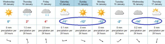
January Thaw - Then January Smack. 3 more days above
freezing, and then a cold slap across the face, starting this weekend
with highs near 10 F, and a wind chill of -10 F. Temperatures recover
(briefly) Tuesday, then fall even more the latter half of next week. By
Thursday temperatures may be stuck in low single digits.
Over The Temperature Cliff. Enjoy the thaw, because
by Saturday there will be NO doubt in your mind that it's mid-January.
Expect a 30 degree temperature drop in less than 24 hours (whipping up
30 mph winds), making it feel like -10 to -15 F. by Sunday morning.
Something to look forward to.
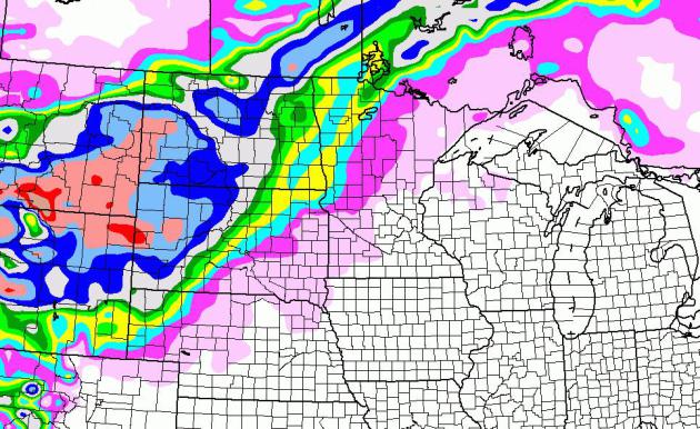
Predicted Snowfall. NAM model guidance shows a
plowable snowfall over the Red River Valley, as much as 2-4" from
Detroit Lakes to Bemidji and Thief River Falls - well over a foot from
the Black Hills of South Dakota into Wyoming.
NCDC Announces Warmest Year On Record For Contiguous U.S. We've been talking about this for weeks - and now
NOAA NCDC makes it official: "
According to NOAA scientists, the average temperature for the contiguous U.S. for 2012 was 55.3°F, which was 3.2°F above the 20th century average
and 1.0°F above the previous record from 1998. The year consisted of
the fourth warmest winter, a record warm spring, the second warmest
summer, and a warmer-than-average autumn. Although the last four months
of 2012 did not bring the same unusual warmth as the first 8 months of
the year, the September through December temperatures were warm enough
for 2012 to remain the record warmest year, by a wide margin. The
average precipitation total for the contiguous U.S. for 2012 was 26.57
inches, 2.57 inches below average, and the 15th driest year on record
for the nation..."
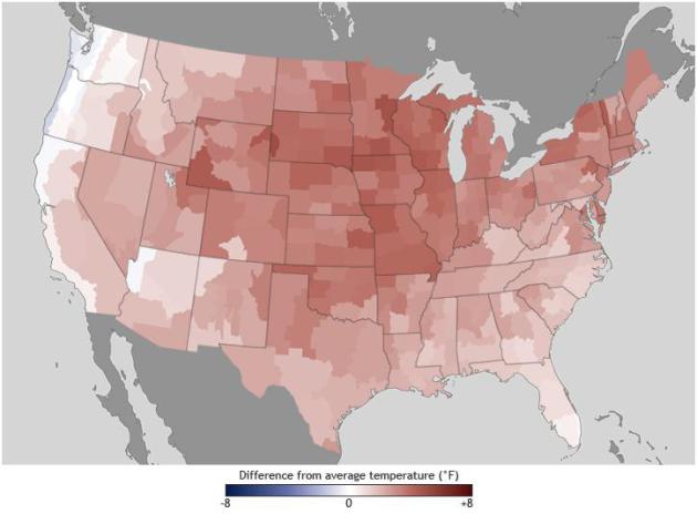
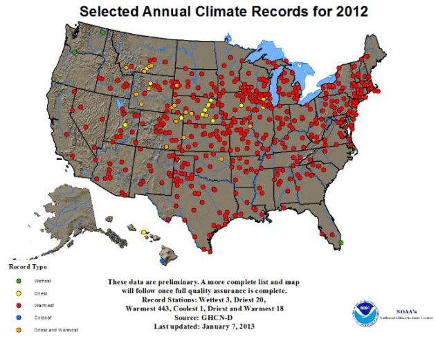
2012: A Year Of Hot and Dry Extremes. All those red
dots littering the map above are cities that experienced their warmest
year ever recorded last year - the yellow dots: driest years on record.
More from
NOAA NCDC: "
Several
locations throughout the United States experienced temperature and
precipitation extremes in 2012. Most striking was the number of
locations across the country that broke their average annual temperature
record. These records were primarily driven by extremely warm maximum
day time temperatures or daily highs, especially during the spring and
summer months. More than a dozen of these locations also experienced
their driest year on record. In those areas, the combination of the
extreme warm and dry period resulted in a drought comparable to the
drought episodes of the 1950s."
* NCDC has a chronological list of the all-time record highs, day by day, for the USA
here.
* globally the 10 warmest years have been observed in the last 15 years.
The New York Times has more on 2012's record warmth.
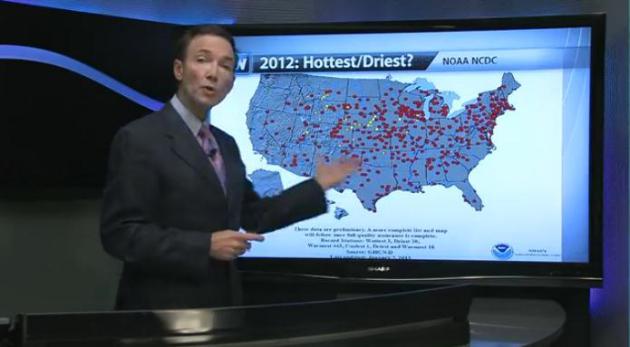
2012: One For The Record Books. The number of U.S.
cities experiencing their warmest (all-time) years last year is
staggering, as I attempt to put into perspective in this 2:30
YouTube clip, courtesy of WeatherNation TV: "
NOAA
today confirmed what many meteorologists suspected. 2012 is officially
the warmest year on record. What was the annual average temperature?
And how much warmer is that than the previous record year?
Meteorologist Paul Douglas breaks down some of the astounding numbers
from 2012."
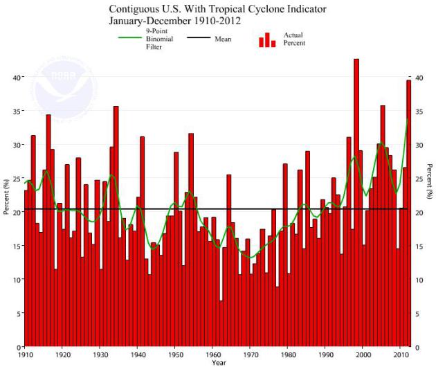
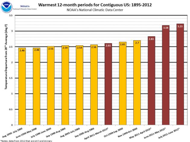
Climate Extreme Index. The
graph
above (courtesy of NOAA NCDC) shows the trend line of U.S. temperature
and moisture extremes. 2012 was second only to 1998, which saw the most
severe El Nino ever recorded. More from
NCDC: "
The
U.S. Climate Extremes Index indicated that 2012 was the second most
extreme year on record for the nation. The index, which evaluates
extremes in temperature and precipitation, as well as landfalling
tropical cyclones, was nearly twice the average value and second only to
1998."
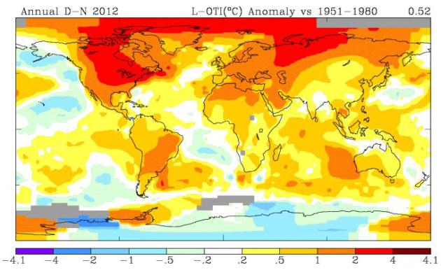
2012 Global Temperature Anomalies. Temperatures were
3-5 degrees (F). warmer than the 1951-1980 global averages from North
America and Siberia into the Arctic. Map above courtesy of
NASA GISS. This is compared to a historical, 20th century baseline of normal global temperatures from 1951-1980.
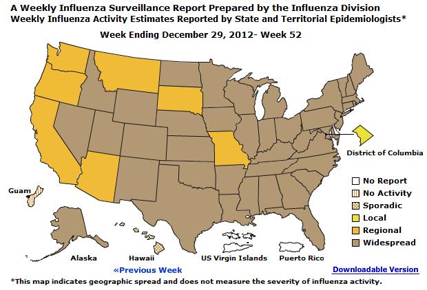
Why I Got Off My Butt And Had A Flu Shot. I watched a
report on CNN last week that almost made me fall of my couch - showing a
giant red stain of "widespread" flu activity in the southern USA,
drifting north, like a bad weather map. The map above shows the latest
flu conditions as reported by the CDC, the
Center for Disease Control in Atlanta. Not good.
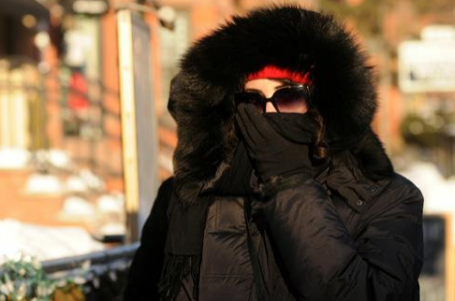
Cold Weather Really Does Spread Flu. This 2007 article is from
NewScientist, but it's as relevant and timely as ever; here's an excerpt: "
Scientists
have finally confirmed what your mother knew all along - that flu
spreads best in cold, dry weather. As the first few cases of the
northern hemisphere's annual flu epidemic are trickling in this week,
scientists may finally know why winter is flu season. It appears the
virus lasts longer in cold, dry air, and our sluggish, cold-weather
mucus cannot clear it out. Astonishingly it has taken until the
publication of research this week to settle the basic question about how
flu spreads, and why it girdles each hemisphere every year during
winter. Ironically, that research was made possible by the rediscovery
of a report by army doctors in 1919..."
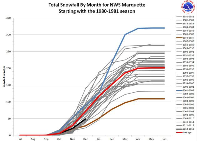
Will We Be Able To Make Up Our Snowfall Deficit?
Only a 1 in 4 chance of "normal" snowfall for the winter season?
Granted, this story was posted by the Marquette, Michigan office of the
National Weather Service, but I believe their logic and trend lines apply (loosely) to Minnesota and our snowfall drought as well. Here's an excerpt: "
With
the limited snowfall at most locations so far this year, the question
becomes “Will we be able to make up our snowfall deficit over the next
couple of months?” ...When you pull out all of the seasons that had
above normal snowfall through December, the potential for normal or
above normal seasonal snowfall diminishes. Of the remaining 16 years,
all but 4 of those years ended up being below normal (see the next
chart below). Those 4 winter seasons were 1982-1983, 1984-1985,
1987-1988, and 2006-2007. Therefore, based on past history, you
could say that we only have a 25% chance of our seasonal snowfall
being normal this season. In addition, when looking at the
last three winter seasons, we have been well below normal on snowfall
(3 season average of 158.5 inches or 44.8 inches below normal)."
Preliminary Info On 2012 U.S. Billion-Dollar Extreme Weather Climate Events.
NOAA NCDC
has the details: "Today, NOAA released preliminary information on
extreme weather and climate events in the U.S. for 2012 that are known
to have reached the $1 billion threshold in losses. As of December 20,
NOAA estimates that the nation experienced 11 such events, to include
seven severe weather/tornado events, two tropical storm/hurricane
events, and the yearlong drought and associated wildfires. These eleven
events combined are believed to have caused 349 deaths, with the most
significant losses of life occurring during Sandy (131) and the
summer-long heat wave and associated drought, which caused over 123
direct deaths (though an estimate of the excess mortality due to heat
stress is still unknown).
The
eleven events include:
- Southeast/Ohio Valley Tornadoes — March 2–3 2012
- Texas Tornadoes — April 2–3 2012
- Great Plains Tornadoes — April 13–14 2012
- Midwest/Ohio Valley Severe Weather — April 28–May 1 2012
- Southern Plains/Midwest/Northeast Severe Weather — May 25–30 2012
- Rockies/Southwest Severe Weather — June 6–12 2012
- Plains/East/Northeast Severe Weather (“Derecho”) — June 29–July 2 2012
- Hurricane Isaac — August 26–31 2012
- Western Wildfires — Summer–Fall, 2012
- Hurricane Sandy — October 29–31 2012
- U.S. Drought/Heatwave — throughout 2012
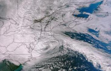
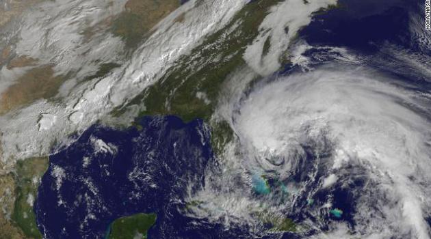
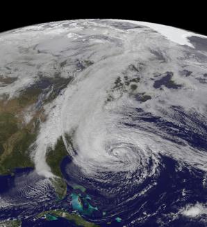
Image credit above: "
This Suomi NPP satellite image shows
Sandy along the mid-Atlantic coastline with its center about 125 miles
southeast of Atlantic City, New Jersey. Sandy was within several hours
of landfall on the southern New Jersey coastline."
America Isn't Ready For Superstorms. This article
follows on the heals of CNN's very solid hourlong Sunday documentary on
"The Coming Storms", highlighting what we're all seeing in the
data: more frequent and intense storms, worldwide, one consequence of a
warming climate. Here's an excerpt of a
CNN article: "...
There
is much that we can and should be doing to better anticipate and
prepare for extreme weather events. As a nation, we also should be
embracing proven cost-effective measures that will reduce the harm that
disasters cause and bolster the speed at which communities can
recover. In the aftermath of Hurricane Sandy, there are five important
lessons to be learned.
1. Water is more destructive than wind. Media
coverage of hurricanes and coastal storms places too much emphasis on
wind speed. While images of trees, road signs, and reporters being
buffeted by high winds make for good video, they distract from the more
serious hazard associated with major storms -- coastal flooding from
storm surge and inland flooding from torrential rains. There need to be
better predictive tools for estimating how much water a storm may bring
and when and where it is likely to go..."
Photo credit above: Brittney Misialek, Storm Prediction Center.
Science, Satellites and Superstorms: Preparing For The Next Big One.
There is growing concern about the age and viability of America's
weather satellite fleet; a failure of one of these (critical)
eye-in-the-sky could temporarily blind meteorologists, and potentially
compromise the accuracy of the weather models we rely on to track
hurricanes and other life-threatening storms. Here's an excerpt of a
CNN article: "...
A
month before the 1,000-mile-wide storm struck the Northeast, at the
height of the hurricane season, the geostationary satellite that
monitors the Caribbean and Atlantic -- where Sandy gathered strength --
stopped working. While there are dozens of American weather satellites
in orbit, these geostationary spacecraft are crucial to predicting
dangerous weather patterns. Luckily, the National Oceanic and
Atmospheric Administration, or NOAA, had a backup satellite to scramble
into place. Without it, the early warning for Sandy's impending strike
on the northeast might not have been as accurate. That close call has
meteorologists worried that, in this era of shrinking budgets, aging
satellites might not get the expensive repairs they need to operate, and
NOAA might not be able to purchase backup satellites..." (Sandy image above courtesy of NOAA).
Tweeting To Save The Day. Who calls 911 when you can
tweet? As social media becomes a tool many use on a daily basis, our
perceptions of how we should send and receive emergency information is
morphing, as described in this blog from
Scientific American; here's an excerpt: "...She cites an amazing statistic: “
Three
out of four Americans expect help when they post something on Facebook
or Twitter” after a disaster. That is, according to a 2012 Red Cross
survey, in the aftermath of disaster, 76% of Americans expect help
within three hours of posting a request on social media. And that’s
without any formal program of social media response. Now of course at
the moment the Red Cross keeps an eye on social media feeds during
disaster response, but there’s no standard for how such a thing should
work...."
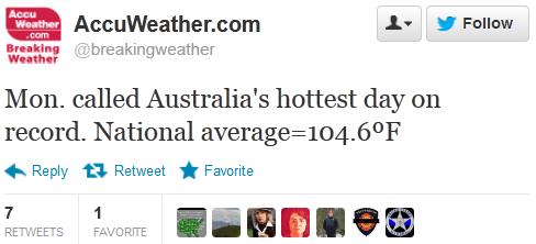
Historic Heat Wave Brings Australia Its Hottest Average Temperature On Record. Jeff Masters has more on the intense (historic) heat gripping Australia in his
Wunderground post; here's an excerpt: "
It's
been a summer like no other in the history of Australia, where a
sprawling heat wave of historical proportions is entering its second
week. Monday, January 7, was the hottest day in Australian history,
averaged over the entire country, according to the Australian Bureau of Meteorology.
The high temperature averaged over Australia was 105°F (40.3°C),
eclipsing the previous record of 104°F (40.2°C) set on 21 December 1972.
Never before in 103 years of record keeping has a heat wave this
intense, wide-spread, and long-lasting affected Australia..."
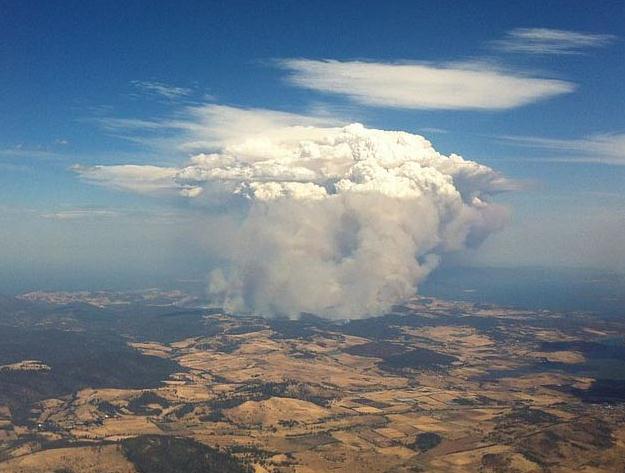
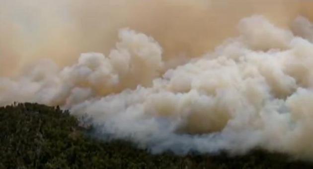
Photo credit above: "
Aerial view of fire at Copping/Forcett, Tasmania, at around 4pm on 4 Jan 2013, taken from an airplane leaving Hobart Airport." Image credit: Wikipedia. Courtesy: Weather Underground.
Record Fires Rage Across Australia. According to CNN
130 major fires are burning across NSW, or New South Wales. These
wildfires are symptoms of the hottest temperatures ever observed Down
Under, as reported by AP (check out the
AP video): "
Firefighters
are battling wildfires raging across southeastern Australia as
authorities evacuated national parks and warned that blistering
temperatures and high winds had led to "catastrophic" conditions in some
areas."
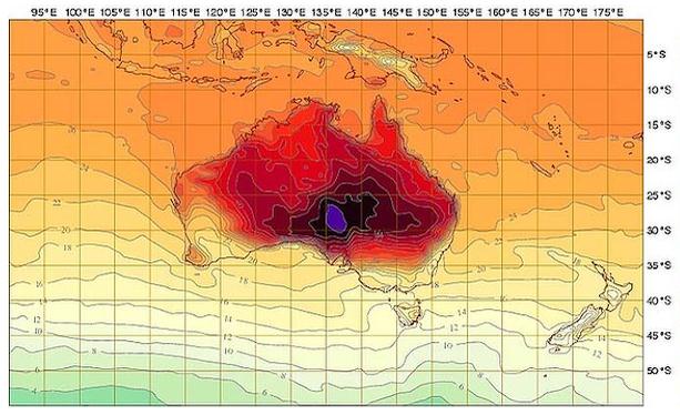
It's So Hot In Australia That They Added New Colors To The Weather Map. This one made me do a double-take, courtesy of
The Atlantic. CNN reports that officials have issued a "catastrophic warning" (which I've never heard of before). Here's an excerpt: "
See
that deep purple in the middle of this acne-red weather report from
Down Under? That right there represents 129.2° F or 54 °C — it's a
brand-new shade that the Australian bureau of meteorology was forced to
add to its heat index because their country is, you know, kind of on
fire. "The scale has just been increased today and I would anticipate it
is because the forecast coming from the bureau's model is showing
temperatures in excess of 50 degrees," David Jones, head of the bureau's
climate monitoring and prediction unit, told The Sydney Morning Herald, which
notes that the previous record high was 50.7°C (123°F), recorded in
1960 at Oodnadatta Airport in the southern part of Australia — right
around where the new shades of hot are showing up today..."
Map above: Australia Bureau of Meteorology, The Atlantic. More on the Australia's blistering heat wave from Australia's
The Age.
Perspective. Here's a
Facebook post that captures the magnitude of the heat baking Australia right now: "
Perth Weather Live. Thanks to Southern Storm Chasing for this Information. These Temperatures are Correct to the 5th of January."
Could Hurricane Forecasting Get Better In 2013? Decoded Science takes a look - here's an excerpt: "...
In
2013, there may be a new tool to help hurricane trackers get people
ready for the storm. A study in the journal Geophysical Research Letters
has discovered that the moisture levels around a hurricane can help
determine whether the hurricane will intensify. Satellite data have
allowed scientists from ASA’s Jet Propulsion Laboratory, Pasadena,
Calif., UCLA and the University of Hawaii at Manoa to discover that
hurricanes that intensify quickly tend to be those that are in a moist
environment. The hurricanes that weaken or stay the same tend to be in
areas with much lower relative humidity. While scientists have
traditionally thought that hurricanes weaken or intensify based on the
conditions inside the hurricane, this study shows that the environment
around a hurricane can change the way a hurricane intensifies..."
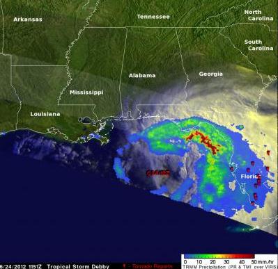
Image credit: file of Tropical Storm Debby courtesy of NASA.
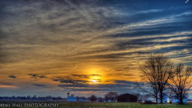
Soul-Soothing Sunset. Thanks to Mike Hall for another remarkable photo from Lewisport, Kentucky, courtesy of WeatherNation TV.
What I'm Reading. For anyone who has faith in the
afterlife, or who has lost a loved one, this will be a comforting,
mind-expanding read, one that may change your life. This doctor was an
agnostic who was very near death, in a week-long coma, but lived to tell
about his NDE, or near death experience. Skeptical? I don't blame you.
But if you're keeping an open mind you might want to order or download
this one. From
Amazon: "
Thousands
of people have had near-death experiences, but scientists have argued
that they are impossible. Dr. Eben Alexander was one of those
scientists. A highly trained neurosurgeon, Alexander knew that NDEs
feel real, but are simply fantasies produced by brains under extreme
stress. Then, Dr. Alexander’s own brain was attacked by a rare illness.
The part of the brain that controls thought and emotion—and in essence
makes us human—shut down completely. For seven days he lay in a coma.
Then, as his doctors considered stopping treatment, Alexander’s eyes
popped open. He had come back. Alexander’s recovery is a medical
miracle. But the real miracle of his story lies elsewhere. While his
body lay in coma, Alexander journeyed beyond this world and encountered
an angelic being who guided him into the deepest realms of
super-physical existence. There he met, and spoke with, the Divine
source of the universe itself. Alexander’s story is not a fantasy.
Before he underwent his journey, he could not reconcile his knowledge
of neuroscience with any belief in heaven, God, or the soul. Today
Alexander is a doctor who believes that true health can be achieved
only when we realize that God and the soul are real and that death is
not the end of personal existence but only a transition."
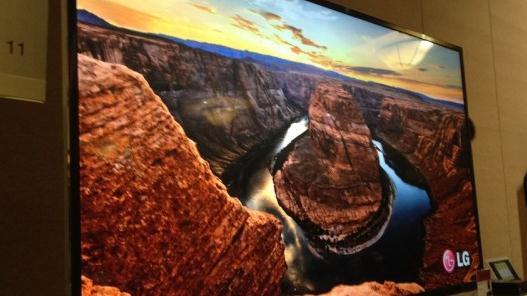
HDTV? That's So 2004. At CES LG showed off a new, 84" 4K, 3-D Smart TV. Got it? Neither do I. Good luck finding 4k content.
Gizmag.com has more details for early (early!) adopters: "
LG has shown its 84-inch 4K 3D 84LM960 television in Las Vegas on the eve of CES 2013.
This is LG's first 84-inch Ultra HD TV, and based on these glimpses of
it from the floor, it certainly looks like the company got it right on
the first try...The Smart TV comes with a dual-core processor and
access to over 1,400 applications. It also features LG's new Magic Remote, which allows users to input commands through gestures and voice commands."
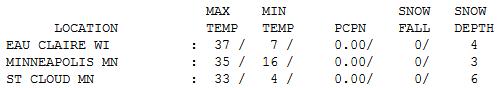
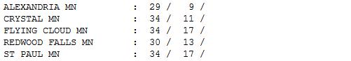
Midwinter Relief. Highs were 10-15 degrees above
average again yesterday, ranging from 29 Alexandria, 30 at Redwood Falls
to 33 St. Cloud, 35 Twin Cities and 37 at Eau Claire.
Paul's Conservation Minnesota Outlook for the Twin Cities and all of Minnesota:
TODAY: Plenty of sun, drippy. Winds: SW 10-15. High: 35
WEDNESDAY NIGHT: Patchy clouds, still mild for January. Low: 26
THURSDAY: Clouds increase, light rain late. High: 37
FRIDAY: Light rain or drizzle. Still mild. Low: 29. High: 38
SATURDAY: Bitter Winds. Light
snow or flurries. Metro coating - but a few inches over the Red River
Valley. Low: 13. High: 16 (winds gusting past 35 mph will make it feel
subzero by late afternoon).
SUNDAY: Cold sun, feels like -10 F. Low: 3. High: 10
MONDAY: Blue sky, a numbing breeze. Low: 4. High: 18
TUESDAY: Next clipper, not as cold. Low: 10. High: 26
* the coldest air of the winter (in all probability) arrives by the end of next week; highs near zero, lows from -10 to -15.
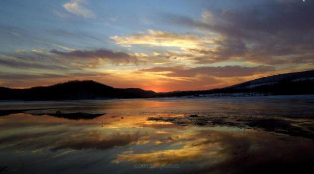
* photo of Canoe Creek State Park, Pennsylvania courtesy of "Spice of Life" on
Facebook.
Climate Stories....
"
While temperatures vary on a local and regional scale, globally
it has now been 27 years since the world experienced a month that was
colder than average...Around the world, 2013 could be the hottest ever
recorded by modern instrumentation, according to a recent study by
Britain’s Met Office. It said that, based on the rising background
warming trend, 2013 will be 0.43 degrees to 0.71 degrees hotter
globally than the average temperature between 1961 and 1990, with a
‘‘best fit’’ of 0.57 degrees warmer..." - from Australia's
The Age. Graph above: NOAA.
Australia Feels Heat Of Climate Change. Here's an excerpt from a story at
Bloomberg News: "
More
than 100 wildfires are raging across the driest inhabited continent,
and the country registered a national average temperature of 40.33
degrees Celsius (104.6 degrees Fahrenheit), the hottest day in more than
a century. But while naysayers continue to question the difference
between weather and climate, scientists in Australia are now displaying
signs of "debate fatigue" as policy makers fail to deliver on the goal
of restricting global warming to 2 degrees Celsius. "Those of us who
spend our days trawling -- and contributing to -- the scientific
literature on climate change
are becoming increasingly gloomy about the future of human
civilization," said Liz Hanna, an environmental-health scientist and
epidemiologist at the Australian National University, to the Sydney Morning Herald.
"We are well past the time of niceties, of avoiding the dire nature of
what is unfolding, and politely trying not to scare the public."
Adapt Or Die: Why The Environmental Buzzword Of 2013 Will Be "Resilience".
Time Magazine
does a good job of summarizing the implications of not only Sandy, but
record drought, more intense rainfall, and an apparent eastward shift of
tornado alley in recent years; here's an excerpt: "
Journalists and
politicians have short memories. Just two months ago, Superstorm Sandy
was everywhere on the news. And it wasn’t just weather porn — there was
serious debate about the impact climate change
had on the storm, and about the now-obvious need to prepare cities for
worse to come. Bloomberg Businessweek put it on the cover—”It’s Global Warming, Stupid“—and in my TIME cover story, I focused on adaptations that cities like New York could make now to ensure that the next storm wouldn’t be so destructive. Politicians like New York Mayor Michael Bloomberg and New York Governor Andrew Cuomo emphasized the need
to rebuild better from Sandy, to ensure that the billions that would
go into storm response would also flow to the sorts of global warming
adaptation initiatives that would climate-proof cities..."
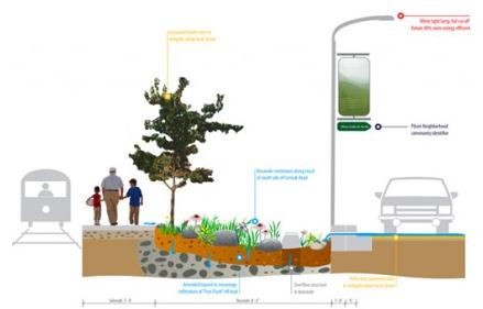
America's "Greenest Street" Provides Blueprint For Sustainable Urban Development.
Gizmag.com has the story; here's a snippet: "
A
streetscape that includes natural landscaping, bicycle lanes, wind
powered lighting, storm water diversion for irrigation,
drought-resistant native plants and innovative “smog-eating” concrete
has earned Cermak road in Chicago the title of “greenest Street in
America” according to the Chicago Department of Transport (CDOT)...."
Graphic credit above: "
The regeneration of Cermak Road includes new sidewalks with permanent wind/solar powered pedestrian lights." (Image: CDOT)
The Global Warming Hot List For 2013. Here's an excerpt from
Mother Nature Network: "...
As for the inevitable, here's your dose of 2013 punditry:
Business Week's stark, post-Sandy cover trumpeting "It's Global Warming, Stupid" will be the herald of a partial media awakening. On Sunday, CNN re-entered the game with an hour-long, prime-time special
on climate and severe storms. Newsrooms will follow the leads of the
New York Times and the Associated Press and bolster their coverage, and
nonprofits like Climate Central, Inside Climate News and TDC will find a wider audience.


No comments:
Post a Comment