29 F. high in the Twin Cities Saturday.
32 F. average high for February 23.
39 F. high on February 23, 2012.
9" snow on the ground at KMSP.
6:59 am sunrise.
5:43 pm sunset.
A "Tough Winter"?
Winters have been trending milder, to the point
where a (nearly average) winter feels like punishment from a vindictive
Old Man Winter.
"Paul, are you going to write about this tough winter we're having?" a friend asked last week. Huh?
Which got me thinking. Has it been that bad?
MSP has picked up 35.5 inches of snow. During an
average winter we should be up to 40 inches by now. 9 subzero nights;
average for an entire winter is 22.5. Based on NWS Heating Degree Days
we've saved roughly 5 percent heating our homes & businesses since
last fall. A tough winter? No, not really.
A reality check, compared to last year's
Memphis-like winter. In spite of climate change we'll still experience
cold fronts and occasional snows. If it ever gets to the point where it
never snows (at all) we'll be past the point of no return.
Quiet weather prevails this week, with a minor
league thaw and a major rain/wind storm tracking well east of Minnesota.
Low to mid 30s give way to 20s by late week, but no more polar
(subzero) air is in sight.
March 2013 won't bring 70s & 80s,
like last year.
But the Spring Parade of Homes kicks off next weekend. Birds are chirping again!
It won't be long now.
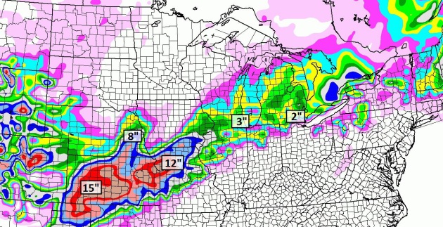
New Snow By Tuesday Night. The
NAM model prints out another snowy drubbing for Kansas, as much as
15-18", maybe another foot for Kansas City. Omaha may pick up 4-6", with
3-4" for Chicago, maybe 2-3" for the Detroit area. Boston picks up 1-2"
later today, much heavier amounts northinto Maine.
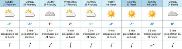 Storm-Free Next 7-10 Days
. The latest ECMWF
(European)
model keeps any significant storms well south of Minnesota, highs at or
above freezing into Thursday, then cooler weather by late week.
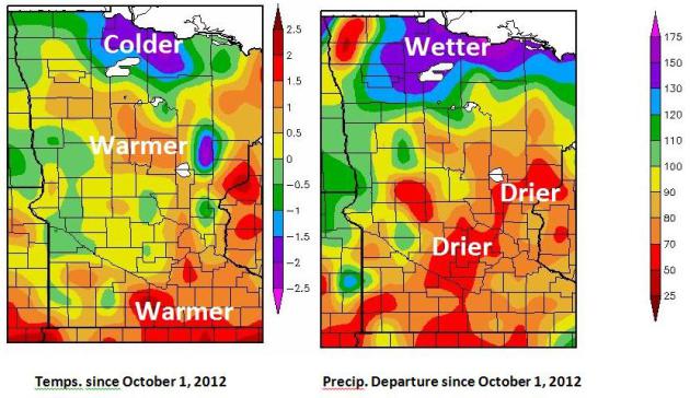
Spring 2013 Climate Outlook. Here's an excerpt of an interesting post (and some great visuals) from the
Grand Forks office of the National Weather Service: "
A
change in the weather pattern brings an increased spring snow-melt
flood risk and the hope to alleviate drought conditions for the growing
season. Since October 2013 temperatures across the Red River Valley have
generally averaged close to normal. The warmest temperatuers have been
across the central portions of the basin with the coldest across the
Upper Devils Lake Basin and along the International Broder region of
north central Minnesota. Departures generally range from 1 degree below
to 1 degree above the median..."
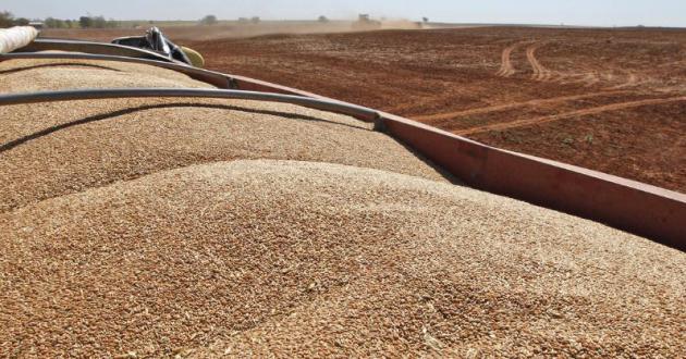
Despite Lingering Drought, USDA Predicts A Flood Of Grain.
NPR has the story - here's a snippet: "
Economists at the U.S. Department of Agriculture, gazing into their crystal ball, see
American farmers planting and harvesting huge amounts of corn,
soybeans, and wheat this year. They're predicting a record harvest of
corn: 14 billion bushels, up nearly 40 percent over last year's
drought-crippled level. With supply up, prices will fall. The USDA
thinks that the price of the average bushel of corn could fall by a
third. And soybean production and price are expected to follow a
similar track..."
Photo credit above: "
John Honeywell uses a grain drill to plant winter wheat near Orlando, Okla., on Sept. 12, 2012. "
Sue Ogrocki/AP Photo
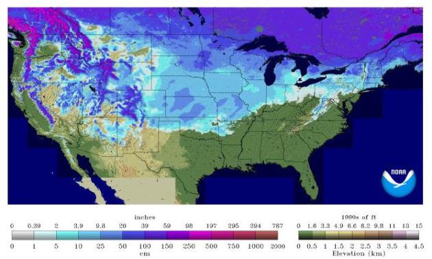
Thin Snowpack In West Signals Summer of Drought. Here's an excerpt from The New York Times (subscription may be necessary to read full text): "
After
enduring last summer’s destructive drought, farmers, ranchers and
officials across the parched Western states had hoped that plentiful
winter snows would replenish the ground and refill their rivers,
breaking the grip of one of the worst dry spells in American history. No
such luck. Lakes are half full and mountain snows
are thin, omens of another summer of drought and wildfire.
Complicating matters, many of the worst-hit states have even less water
on hand than a year ago, raising the specter of shortages and
rationing that could inflict another year of losses on struggling farms..." (USA snow cover map above courtesy of
NOAA).
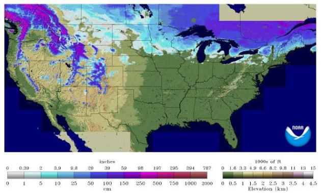
February 23, 2012 Snow Cover. I was struck by the
difference from last year at this time, when only 23% of the USA had any
snow on the ground (vs. 56% now). The lack of snowcover was one factor
in record March warmth and thousands of record highs. We'll see a
warming trend next month, but I doubt we'll see anything equivalent to
2012, when flowers were blooming in Minnesota by late March. Just a
hunch.
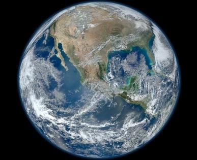
Earth's Average Temperature For January Ties As 9th Warmest On Record: NOAA. Details from
Huffington Post:
"The globally-averaged temperature for January 2013 tied with 1995 as
the ninth-warmest January since record keeping began in 1880, according
to a news release today from the National Oceanic and Atmospheric
Administration. The combined average January temperature over global
land and ocean surfaces was 54.57 degrees Fahrenheit, or 12.54 degrees
Celsius.
This January marked the 37th consecutive January and
also the 335th consecutive month with a global temperature above the
20th Century average, NOAA reported..."
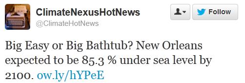
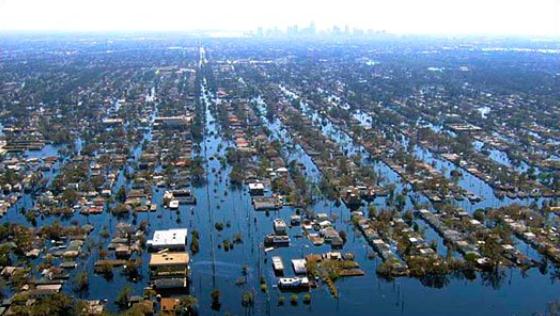
Louisiana May See The Fastest Rising Seas In The World. Here's an excerpt from
Grist: "
As
Hurricane Katrina approached, many Americans for the first time
learned about New Orleans’ precarious, below-sea-level orientation. The
city is described as “bowl-like,” rimmed
by levees and natural structures that might not hold back surging
storm water — and might make drying out nearly impossible. It turned
out that the analogy was imperfect. New Orleans is more like a TV
dinner tray, and only the Ninth Ward ended up flooded....From The Lens:
Stunning new data not yet publicly released shows Louisiana losing its
battle with rising seas much more quickly than even the most
pessimistic studies have predicted to date. …Southeast Louisiana — with
an average elevation just three feet above sea level — has long been
considered one of the landscapes most threatened by global warming.
That’s because the delta it’s built on — starved of river sediment and
sliced by canals — is sinking at the same time that oceans are rising.
The combination of those two forces is called relative sea-level rise,
and its impact can be dramatic...."
32 Reasons Why Minnesota Has The Greatest State Fair In The Country. Hey, it's not just me waving the flag; this comes from
buzzfeed.com. I just happen to agree (that's chicken fried bacon above - comes with a cardiologist).
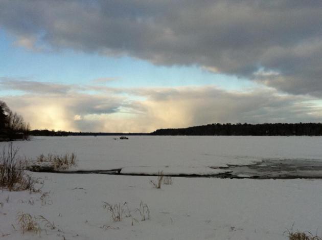
Feeling Better About February. With peeks of sun and
highs in the upper 20s to low 30s it almost felt tolerable out there.
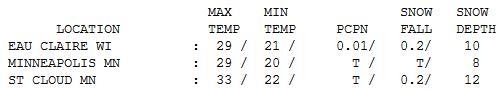
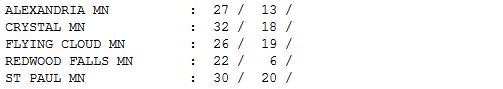
St. Cloud reports 12" of snow on the ground, 10" at Eau Claire.
Paul's Conservation Minnesota Outlook for the Twin Cities and all of Minnesota:
TODAY: Partly sunny, hints of March. Winds: SE 5. High: 33
SUNDAY NIGHT: Patchy clouds, no weather worries. Low: 17
MONDAY: Mostly cloudy skies. High: 32
TUESDAY: More clouds than sun. Wake-up: 20. High: 34
WEDNESDAY: Peeks of sun, still quiet. Wake-up: 23. High: 35
THURSDAY: Cloud-cluttered, average temps. Wake-up: 22. High: 32
FRIDAY: Partly sunny, a bit cooler. Wake-up: 18. High: 28
SATURDAY: Intervals of clouds & sun. Wake-up: 14. High: 26
* photo above courtesy of Tim Wright.
Climate Stories...
"Climate Change Lowering Great Lakes Water Level". Here's a snippet of a story at
Mlive.com
that caught my eye: "...
One thing I hear is, ‘This is all caused by
drought,’” Gauthier told a room of about 40 people. “Don’t let people
tell you this is caused by drought. We are in climate change. “There’s
no politics here.” He said the lake’s current condition represented “a
whole different paradigm.” “The last time the water was this low for
this long was the Dust Bowl,” Gauthier said of the 1930s-era ecological
event. He talked about the consequences of the low lake levels. Those
include freighters which carry lighter loads, the reduction in hydraulic
water power at sites such as Niagara Falls, impacts on the fishing
industry, decreased recreational boating and collapsing seawalls..."
Study: Gas Taxes Are Six Times As Effective As Stricter Fuel-Economy Standards. Here's an excerpt of an article at
The Washington Post: "
What’s
the best way to curtail gasoline consumption? Economists tend to agree
on the answer here: Higher gas taxes at the pump are more effective
than stricter fuel-economy standards for cars and trucks. Much more
effective, in fact. A new paper
from researchers at MIT’s Global Change program finds that higher gas
taxes are “at least six to fourteen times” more cost-effective than
stricter fuel-economy standards at reducing gasoline consumption. Why is
that? One of the study’s co-authors, Valerie Karplus, offers a basic
breakdown here:
Fuel-economy standards work slowly, as manufacturers start selling
more efficient vehicles, and people retire their older cars and trucks.
That turnover takes time. By contrast, a higher gas tax kicks in
immediately, giving people incentives to drive less, carpool more, and
buy more fuel-efficient vehicles as soon as possible..."


No comments:
Post a Comment