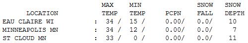
34 F. high in the Twin Cities Sunday.
32 F. average high for February 24.
30 F. high on February 24, 2012.
8" snow on the ground at KMSP.
Quiet week - daytime highs above 32 F thru Thursday.
No major storms brewing for MSP for the next 7-9 days.
Pothole Weather
The coldest days of winter are behind us now.
Today the sun will be as high in the sky as it was on October 15. You
can feel the difference when you walk out the door now; that sun has a
bit more attitude than it did earlier this month.
As temperatures rise and fall above 32F the
freeze-thaw cycle is in full swing. Be on the lookout for ice dams, and
potholes will proliferate in the weeks ahead. During the day snowmelt
drains into cracks in roadway surfaces. At night that water freezes -
and expands. Repeat day after day, add traffic to further weaken the
asphalt or concrete, and you can wind up with some Apollo 11-size
craters on area highways.
Everything is relative, as a buddy recently
reminded me. "The west has earthquakes & wildfires, the south and
east endure hurricanes." Suddenly the potholes, ice dams and cold fronts
don't look quite so forbidding.
Heavy snow pastes Kansas City and Chicago into
midweek, but I expect a quiet week here; highs top 32F into Thursday. I
expect a few slushy, sloppy, plowable snowfalls in early March, but no
more subzero air is brewing.
A word to snow lovers: make the most of the next week or so. It won't get much better than this.
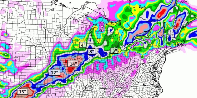
New Snow By Midnight Wednesday. The NAM model prints
out some 12-15" amounts from the Panhandle of Texas and Oklahoma into
Kansas City and southern Iowa. St. Louis may pick up 2-5" of slush, with
as much as 4" at Madison and possibly 6-8" in Chicago. No snowy
problems for Minnesota or the Dakotas thru at least the end of the week.
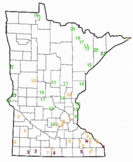
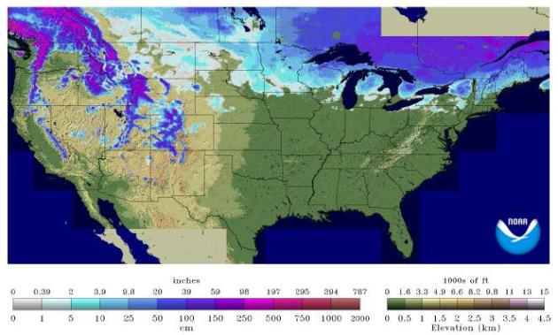
Minnesota Snow Cover. This
NOAA map
is a bit hard to read, more of an eye test than a map, but it shows
7-11" snow on the ground in the Twin Cities metro, closer to 4-7" over
much of southern Minnesota, about 10-16" in the Lake Mille Lacs area,
11" at Brainerd, 15-16" at Duluth and 23" on the ground at Grand Marais.
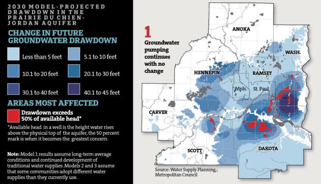
Minnesota Draining Its Supplies Of Water. When I
speak in public I touch on water, and people are often startled when I
tell them my long range prediction: water will quickly become the most
precious natural resource of the 21st century, not oil or gas. Living in
Minnesota, with our fabled 10,000 plus lakes, it's easy to take water
for granted. Lake water levels are low from a persistent drought, but
the greatest concern is underground aquifers, which take much longer to
recharge. Here's an excerpt of an excellent article on the subject from
The Star Tribune: "...
Minnesotans
have always prided themselves on their more than 10,000 lakes, great
rivers and the deep underground reservoirs that supply three-fourths of
the state’s residents with naturally clean drinking water. But many
regions in the state have reached the point where people are using
water — and then sending it downstream — faster than the rain and snow
can replenish it. Last year, Minnesotans used a record amount of water,
fueling a rising number of conflicts from the Iron Range to Pipestone.
Now state regulators, who have never said no to a water permit, for the
first time are planning to experiment with more stringent rules that
will require some local communities to allocate scarce water. “It’s
scary,” said Dennis Healy, who runs the Pipestone Rural Water System in
southwest Minnesota. “The time is coming that there is going to have
to be some rationing...”
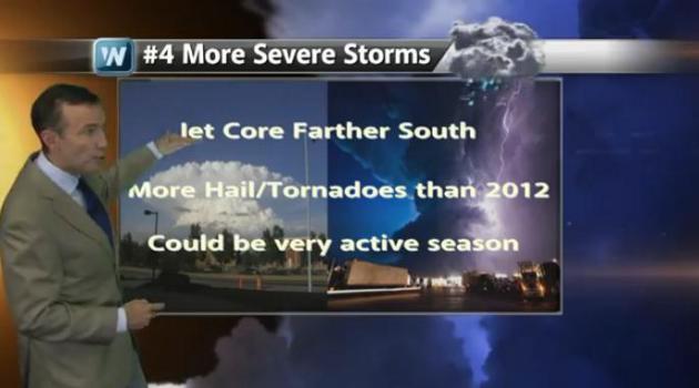
Career-Limiting Behavior. O.K. Let me remind
everyone that specific predictions of temperature and precipitation are
pretty much impossible beyond 21 days, give or take, depending on the
pattern. Good luck beyond 3 weeks, and many times the 3 day forecast is
difficult. But we also track the Big Picture, the trends, looking at
blocking patterns, oscillations, ENSO and other factors to get a sense
of what the long-term picture will look like. It's rare to get two years
that are nearly identical, and I believe 2013 will be a different kind
of weather-year than 2012, which was overshadowed by record heat,
drought, and fewer severe storms/tornadoes over the Plains. I'm pretty
convinced I'll get at least 3 or 4 of my 6 predictions right - just not
sure which ones. The YouTube clip is
here, courtesy of WeatherNation TV. Main themes:
1). Minnesota's drought will ease.
2). Gradual moisture recovery across Midwest - drought persists over Central Plains and Southwestern USA.
3). Summer: warmer than average nationwide, but not as hot as 2012.
4). More severe storms and tornadoes than 2012 as jet core shifts south.
5). The Groundhot Lied. Spring comes late this year for Minnesota and northern tier cities.
6). More "Black Swan" weather events: extreme floods, higher risk of
major urban tornadoes (recent trends show more large/violent tornadoes
east of Mississippi River; another very active year for hurricanes).
A Bit of a Break. Where else on the planet, except
for Moscow, Oslo and possibly Fairbanks, would the locals be relieved to
see low to mid 30s? Here in The Land of Low Weather Expectations 30s in
late February can be interpreted as a warm front. It should actually
feel pretty good out there into Thursday, a slight cooling trend early
next week. Nothing subzero is in sight looking out 2 weeks.
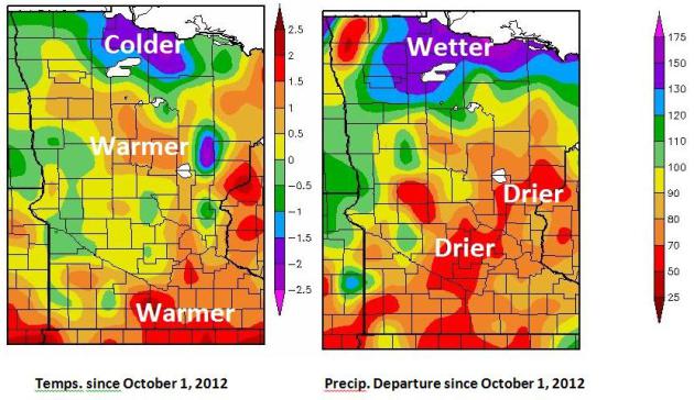
Spring 2013 Climate Outlook. Here's an excerpt of an interesting post (and some great visuals) from the
Grand Forks office of the National Weather Service: "
A
change in the weather pattern brings an increased spring snow-melt
flood risk and the hope to alleviate drought conditions for the growing
season. Since October 2013 temperatures across the Red River Valley have
generally averaged close to normal. The warmest temperatuers have been
across the central portions of the basin with the coldest across the
Upper Devils Lake Basin and along the International Broder region of
north central Minnesota. Departures generally range from 1 degree below
to 1 degree above the median..."
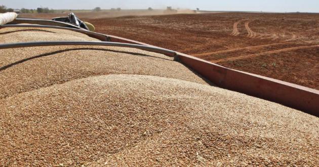
Despite Lingering Drought, USDA Predicts A Flood Of Grain.
NPR has the story - here's a snippet: "
Economists at the U.S. Department of Agriculture, gazing into their crystal ball, see
American farmers planting and harvesting huge amounts of corn,
soybeans, and wheat this year. They're predicting a record harvest of
corn: 14 billion bushels, up nearly 40 percent over last year's
drought-crippled level. With supply up, prices will fall. The USDA
thinks that the price of the average bushel of corn could fall by a
third. And soybean production and price are expected to follow a
similar track..."
Photo credit above: "
John Honeywell uses a grain drill to plant winter wheat near Orlando, Okla., on Sept. 12, 2012. "
Sue Ogrocki/AP Photo
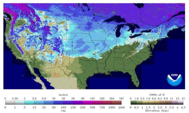
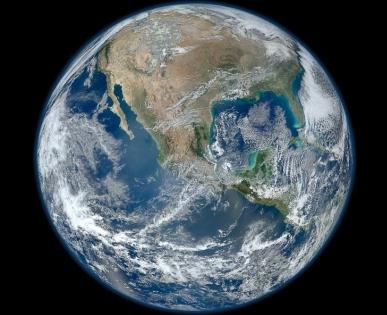
Thin Snowpack In West Signals Summer of Drought. Here's an excerpt from The New York Times (subscription may be necessary to read full text): "
After
enduring last summer’s destructive drought, farmers, ranchers and
officials across the parched Western states had hoped that plentiful
winter snows would replenish the ground and refill their rivers,
breaking the grip of one of the worst dry spells in American history. No
such luck. Lakes are half full and mountain snows
are thin, omens of another summer of drought and wildfire.
Complicating matters, many of the worst-hit states have even less water
on hand than a year ago, raising the specter of shortages and
rationing that could inflict another year of losses on struggling farms..." (USA snow cover map above courtesy of
NOAA).
February 23, 2012 Snow Cover. I was struck by the
difference from last year at this time, when only 23% of the USA had any
snow on the ground (vs. 56% now). The lack of snowcover was one factor
in record March warmth and thousands of record highs. We'll see a
warming trend next month, but I doubt we'll see anything equivalent to
2012, when flowers were blooming in Minnesota by late March. Just a
hunch.
Earth's Average Temperature For January Ties As 9th Warmest On Record: NOAA. Details from
Huffington Post:
"The globally-averaged temperature for January 2013 tied with 1995 as
the ninth-warmest January since record keeping began in 1880, according
to a news release today from the National Oceanic and Atmospheric
Administration. The combined average January temperature over global
land and ocean surfaces was 54.57 degrees Fahrenheit, or 12.54 degrees
Celsius.
This January marked the 37th consecutive January and
also the 335th consecutive month with a global temperature above the
20th Century average, NOAA reported..."
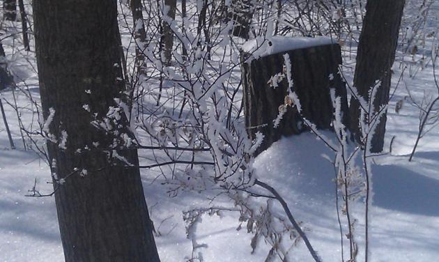
Rime Ice. Thanks to Kim Twigg up in Crosby, who sent
in this photo of ice crystals sticking to tree branches (and just about
everything else) Sunday morning.
Edging Ever Upward. With a sun angle as high as it
was in mid-October you could feel the difference over the weekend; the
sun packing (a little) more umph. Highs ranged from 26 at Alexandria to
33 St. Cloud and 34 in the Twin Cities. St. Cloud has 11" snow on the
ground.
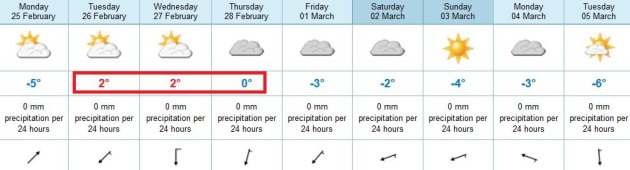
Paul's Conservation Minnesota Outlook for the Twin Cities and all of Minnesota:
TODAY: Intervals of sun. Not bad. Winds: SW 5. High: 34
MONDAY NIGHT: Patchy clouds and fog. Low: 21
TUESDAY: Some sun, above average temps. High: 35
WEDNESDAY: More clouds than sun, quiet. Wake-up: 23. High: 34
THURSDAY: Partly sunny, happy to be bored. Wake-up: 22. High: 33
FRIDAY: Mostly cloudy, a bit cooler. Wake-up: 18. High: 29
SATURDAY: Weak clipper - few flakes. Wake-up: 15. High: 28
SUNDAY: Mix of clouds and sun. Dry sky. Wake-up: 14. High: 28
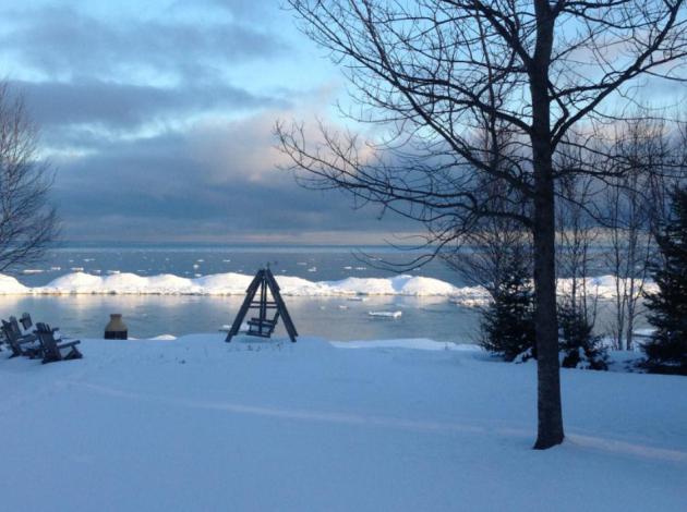
* photo above courtesy of my friend, Pete Schenck, who snapped this
photo on his Lake Superior shoreline up in Herbster, Wisconsin.
Climate Stories...
Department Of Defense Launches Attack On Climate Change. Here's an excerpt from
cleantechnica.org: "
The U.S. Department of Defense has been among the most aggressive leaders on climate change action under the Obama Administration, and it has just stepped it up to the next level. Last week, DoD released the new Climate Change Adaptation Roadmap,
its blueprint for addressing the effects of climate change in a
national security context. That includes global impacts such as
geopolitical consequences, conflict acceleration and competition for
food, water and other life-sustaining resources, as well as increasing
demands on DoD resources for humanitarian relief..."
GOP Can Be Part Of Climate Change Solution. Here's a snippet of an Op-Ed at Boulder's
Daily Camera: "...
Time
and again, conservatives exhort the power of the free market rather
than government to make good things happen in our society. It's time,
then, for Republicans to "walk the talk" and embrace a tax on carbon
that returns revenue to the public. Greg Mankiw, economic advisor to
President George W. Bush and presidential candidate Mitt Romney,
explains the conservative rationale for a carbon tax: "Economists have
long understood that the key to smart environmental policy is aligning
private incentives with true social costs and benefits. That means
putting a price on carbon emissions, so households and firms will have
good reason to reduce their use of fossil fuels and to develop
alternative energy sources..."
"Climate Change Lowering Great Lakes Water Level". Here's a snippet of a story at
Mlive.com that caught my eye: "...
One
thing I hear is, ‘This is all caused by drought,’” Gauthier told a
room of about 40 people. “Don’t let people tell you this is caused by
drought. We are in climate change. “There’s no politics here.” He said
the lake’s current condition represented “a whole different paradigm.”
“The last time the water was this low for this long was the Dust Bowl,”
Gauthier said of the 1930s-era ecological event. He talked about the
consequences of the low lake levels. Those include freighters which
carry lighter loads, the reduction in hydraulic water power at sites
such as Niagara Falls, impacts on the fishing industry, decreased
recreational boating and collapsing seawalls..."
Study: Gas Taxes Are Six Times As Effective As Stricter Fuel-Economy Standards. Here's an excerpt of an article at
The Washington Post: "
What’s
the best way to curtail gasoline consumption? Economists tend to agree
on the answer here: Higher gas taxes at the pump are more effective
than stricter fuel-economy standards for cars and trucks. Much more
effective, in fact. A new paper
from researchers at MIT’s Global Change program finds that higher gas
taxes are “at least six to fourteen times” more cost-effective than
stricter fuel-economy standards at reducing gasoline consumption. Why is
that? One of the study’s co-authors, Valerie Karplus, offers a basic
breakdown here:
Fuel-economy standards work slowly, as manufacturers start selling
more efficient vehicles, and people retire their older cars and trucks.
That turnover takes time. By contrast, a higher gas tax kicks in
immediately, giving people incentives to drive less, carpool more, and
buy more fuel-efficient vehicles as soon as possible..."


No comments:
Post a Comment