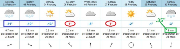
-13 F. low Friday morning in the Twin Cities (MSP International), coldest of the winter.
2 F. high yesterday.
25 F. average high for February 1.
32 F. high on February 1, 2012.
26 more days until the end of "Meteorological
Winter". Historically the coldest temperatures of winter are from
roughly December 1 thru March 1.
All Uphill
Friday morning. 13 below. I'm walking (briskly)
into my office. I see a friend, who shakes her head and groans. "This is
it. This is rock bottom! It's all uphill from here" I explain, in a
soothing weather-therapist voice. "Are you talking about the weather, or
life in general?" she laughs.
Point taken. O.K. We've been hibernating for
nearly 2 weeks. I can say, with a high degree of misplaced confidence,
that the worst of the chill is behind us. We top 30 F next week, in fact
long-range guidance shows highs in the 20s and 30s the first 2 weeks of
February; maybe one subzero night Feb. 14.
I can deal with that.
A friend just drove his Polaris sleds up to the
U.P. of Michigan. "Can't beat lake effect!" he bragged. "At least it's
predictable."
What will it take for us to see a real snow
storm? The last big dump was 10" on Dec. 9. Until big Pacific storms
push inland, turning steering winds to the southwest, allowing Gulf
moisture to bubble north, it'll be tough getting heavy snow in here. A
series of clippers may drop a little snow Sunday, Tuesday, and a week
from tomorrow.
In my blog (below): a big warming warming trend
next week east of the Rockies, implications of a positive NAO - and Lake
Superior is one of the fastest warming lakes in the world.
* image above of the Duluth harborfront from
duluthharborcam.com and Jill Thrasher at Health Partners.
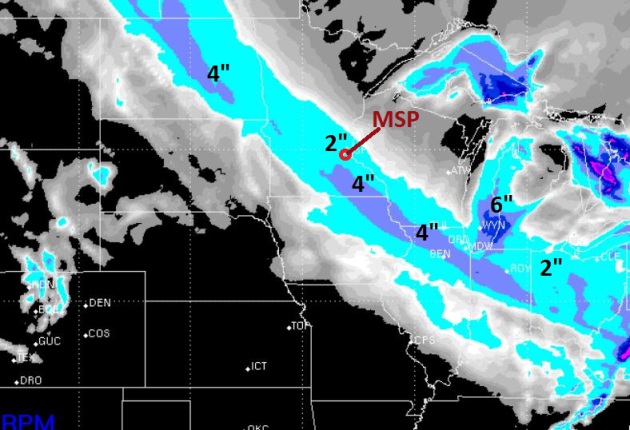
72 Hour Snowfall. A series of
fast-moving Alberta Clippers will create just enough lift for 2-3 bursts
of snow between now and Monday evening. WSI's RPM model shows another
2" of snow between now and Monday in the Twin Cities, maybe 4" closer to
Mankato and Rochester. When it's this chilly it doesn't take much lift
to whip up a quick inch or two of powdery snow. Fluffy, Aspen-snow you
can almost blow off your driveway. Use a shovel, so the neighbors don't
stare.
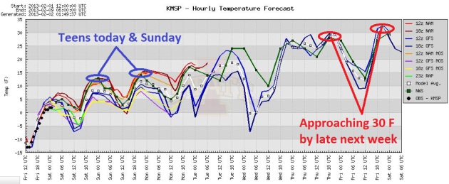
Clawing Out Of The Deep-Freeze.
Teens will feel pretty good today and tomorrow. I know - pathetic, but
after -13 F. Friday morning we're heading in the right direction. 20s
are likely early next week, a better chance of clipping 30 F. by the end
of next week.
The End Is Near. To Nanook
temperatures, that is. The ECMWF (European) model shows a high near
freezing Tuesday and Thursday of next week. A few inches of snow may
fall from a series of Alberta Clippers into Thursday, and then a more
significant snow is possible a week from tomorrow, from a southern
storm. Don't get your hopes up just yet.
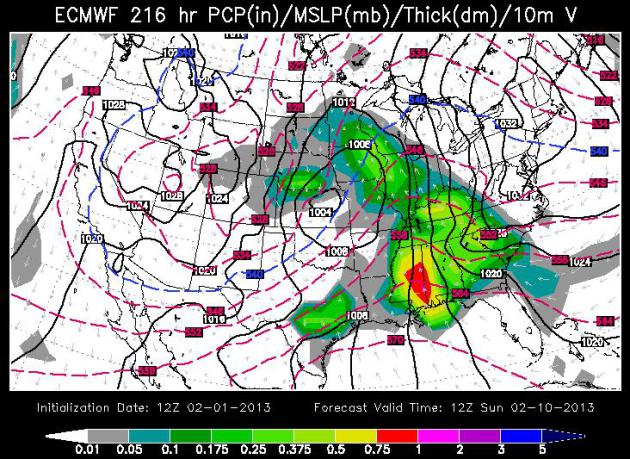
Circle Your Calendar.
Confidence levels are still exceedingly low, but there's a least a
chance of more significant snow next Sunday (Feb. 10). The weather map
at 12z on Feb. 10 shows a strengthening storm west of Kansas City,
pushing a shield of rain and wet snow into the Upper Midwest. Gulf
moisture should get wrapped up into this storm - it's still way too
early to know if we'll see anything significant, but we'll keep an eye
on it. ECMWF guidance: WSI.
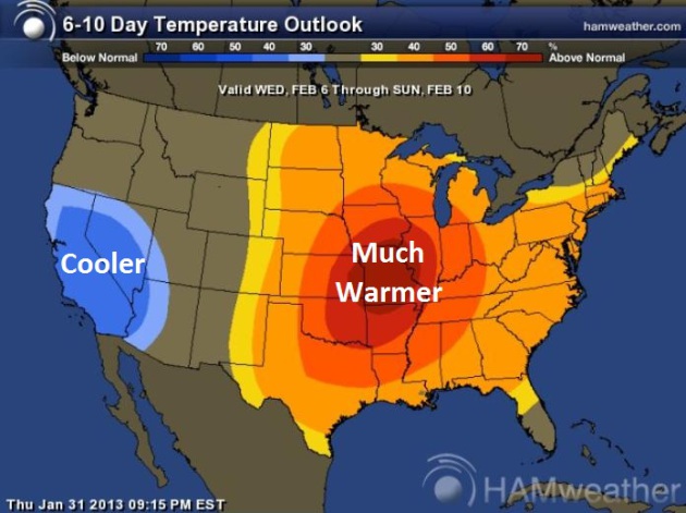
A Sight For Cold, Sore (Runny) Eyes.
All this cold dry weather is wreaking havoc with my contact lenses -
it feels like Frisbees in there. I'm looking forward to a warming
trend, and a little more water in the air. The 6-10 Day Temperature
Outlook from NOAA CPC shows a big warming trend east of the Rockies,
cooler than average for the southwest. Map:
Ham Weather.
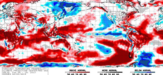
Extended Outlook: Warming. Here is NOAA CPC's
NAEFS Temperature Outlook
from February 9-15 for the entire planet. It looks like winter may be
finally losing its grip over Asia and parts of North America. We've had a
very cold couple of weeks, but most of America has not seen the frigid
air experienced from the Dakotas and Great Lakes to New England, a
glancing blow of frigid air.
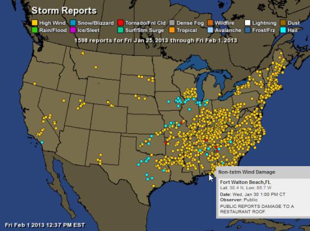
Nearly 1600 Severe Weather Reports The Last Week.
Welcome to "March-uary". I can't remember the last time I saw 1,598
separate reports of tornadoes, severe straight-line winds and hail in a
single January week. Map above: SPC and
Ham Weather.
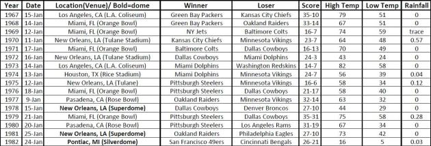
Superbowl Weather Since 1967. Here's a very interesting excerpt from this week's edition of Mark Seeley's always-informative
Weathertalk Newsletter: "...
The
NOAA Southeast Regional Climate Center has documented the climatology
for all Super Bowls from 1967-2012. It is interesting reading to see
how the weather has varied for this significant event despite the
fact that most of the time it is played in the southern USA where the
weather is relatively mild. Interestingly enough, next year's Super
Bowl is scheduled for East Rutherford, NJ outdoors, so it could be
played in snow and cold. You can read more at....http://www.sercc.com/SuperBowlClimate.pdf"
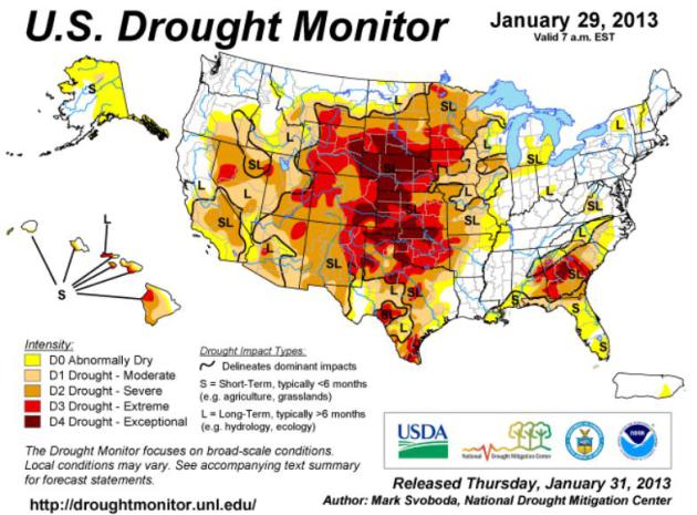
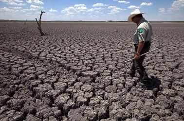
A Very Stubborn Drought. Here's the latest
U.S. Drought Monitor,
showing "exceptional drought" conditions from South Dakota, Wyoming
and Nebraska southward to Oklahoma and parts of Texas, another pocket
of very dry conditions over Georgia and South Carolina. Here's an
overview for the Midwest: "
There was some late period precipitation
across northeastern Iowa, northern Illinois and southern Wisconsin
this past week, but given the deficits, lack of impacts and frozen
top soils, it isn’t enough to move the drought off its mark, so
status quo is the word this week."
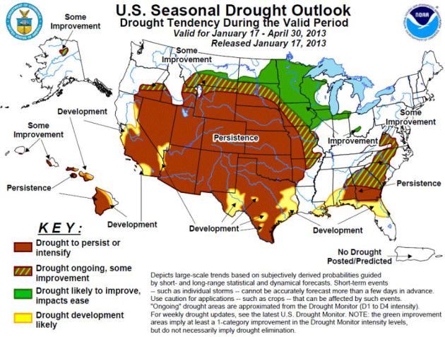
Drought Outlook Through Late April.
NOAA CPC
is still indicating "some improvement" for the drought gripping
Minnesota, western Wisconsin and the northeastern half of Iowa, but
"persistence" for much of the Plains and Southwest, meaning no change.
In fact the drought is forecast to get worse from California and the Las
Vegas area into Texas and the Gulf Coast.
The Big Lag. If the shortest day of the year (and
lowest sun angle) falls around December 21, why does the coldest weather
of the year, historically, arrive 3-4 weeks later? An explanation of
all the factors involved, and why there's a very good chance the worst
cold of winter is finally behind us, in this
YouTube clip, courtesy of WeatherNation TV.
Tracking An Extra-Extreme January. Nearly 800
separate severe weather reports Tuesday and Wednesday, nationwide?
That's the most since late July, 2012, and it's odd seeing this kind of a
spike in extreme straight-line winds and tornadoes...in late January.
Check out the
2:30 YouTube clip: "
There
are hundreds of storm reports from the January 29th and 30th severe
outbreak. And those reports span across several states from the
Southeast to the Lower Ohio Valley and the Northeast. Meteorologist
Paul Douglas looks at how rare this January outbreak is and discusses
what could be in store during the months ahead."
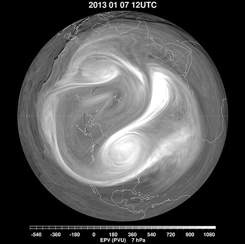
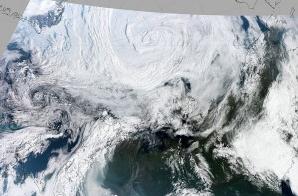
GOES-5 Tracks Major Sudden Stratospheric Warming Event Of January.
The polar vortex suddenly split up into 3 smaller vortices in January,
preceded by a sudden upward spike in stratospheric temperatures in the
upper atmosphere. Details via
NASA: "
Stratospheric
sudden warmings (SSWs) are a ubiquitous feature of the wintertime
flow in the northern hemisphere. Discovered more than sixty years ago
(Sherhag, 1952) when radiosonde observations began to provide routine
observations at altitudes higher than 20km above the surface of the
earth, these events take their name from a rapid temperature increase
of several tens of Kelvin over a few days in the high northern
latitudes. Since the initial discovery of this warming, routine
radiosonde observations and satellite datasets have been used to
construct a fairly complete picture of the dynamical nature of these
events, which are caused by the propagation and evolution of planetary
scale wave motions in the troposphere and stratosphere. A major
midwinter SSW event occurs when polar stratospheric temperatures
increase by at least 25 K in one week, and the zonal-mean zonal wind at
or near 10 hPa (at about 30km altitude) reverses direction and becomes
easterly north of 60° N. Research has led to a good documentation of
the frequency and seasonality of sudden warmings: just over half of
the winters since 1960 have experienced a major warming event in
January or February (e.g., Charlton and Polvani, 2007). The event in
early January 2013 is thus not atypical, but, like all of these
events, has unique dynamical characteristics in terms of its
development and interactions with the tropospheric flow..."
Image credit above: "
January 7, 2013, showing the breakdown of the polar vortex into three smaller vortices." NASA.
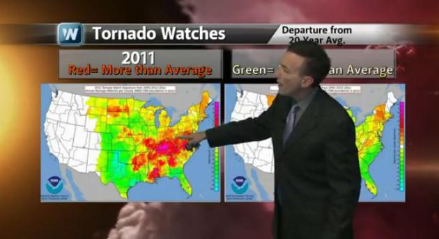
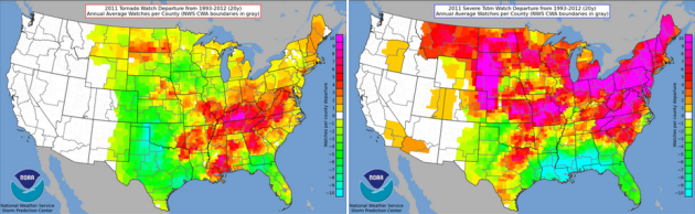
2011: North/East Shift Of Severe Watches Issued.
2011 may have been the most extreme year, weatherwise, in U.S. history.
One interesting nugget from NOAA shows the departure from the 20-year
normal in Tornado Watches (upper left) and Severe Storm Watches (upper
right). Tornado Alley shifted toward "Dixie Alley", over the Ohio Valley
and Mid South, while far more (than average) Severe Storm Watches were
issued for northern states, from the Dakotas to New England. Source:
NOAA.
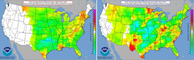
2012: What A Difference A Drought Makes. With last
year's record heat, and the worst drought for the Plains since the
1950s, there was no upward spike in Tornado Watch Issuance from SPC
(upper left), in fact it was one of the quietest years on record for
traditional Tornado Alley. More Severe Storm Watches than average were
observed over the Minnesota Arrowhead and parts of the Ohio Valley.
Cyclone Did Not Cause 2012 Record Low For Arctic Sea Ice.
There has been some debate in scientific circles about the ultimate
trigger for record Arctic sea ice last September. Was it due to
warming/melting, or did an unusually intense August storm at the top of
the world help to break up sea ice? Here's an excerpt from the
University of Washington: "...
But
new results from the University of Washington show that the August
cyclone was not responsible for last year’s record low for Arctic sea
ice. The study was published online this week in Geophysical Research Letters.
“The effect is huge in the immediate aftermath of the cyclone, but
after about two weeks the effect gets smaller,” said lead author Jinlun Zhang,
an oceanographer in the UW’s Applied Physics Laboratory. “By
September, most of the ice that melted would have melted with or
without the cyclone.” Recent research showed that the Arctic cyclone
was the most powerful ever seen during the month of August, and the
13th most powerful of all Arctic storms in more than three decades of
satellite records..."
Image credit above: NASA Earth Observatory. "
An unusually large, long-lasting and powerful cyclone churned over the Arctic in early August 2012."
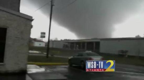
Tornado Forms In Front Of WSB's Ross Cavitt. The tornado that hit Adairsville (northwest Georgia) Wednesday morning was a strong EF-3; winds over 110 mph.
TVSpy has more details on how this (remarkable) footage was captured - right place - right time: "
At
least one person is dead after a tornado touched down in Adairsville,
Ga., Wednesday afternoon. Footage of the tornado was captured by WSB reporter Ross Cavitt,
who had just arrived on the scene and was reporting from about a
quarter mile away (video above). All four Atlanta stations — ABC
affiliate WSB, CBS affiliate WGCL, NBC affiliate WXIA and Fox O&O WAGA
— have been in continuing coverage of the severe weather for several
hours. The area remains under a severe thunderstorm warning. [via CNN]"
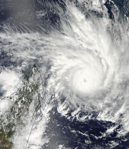
Cyclone's "Overshooting Tops" Seen From Above. Here's a snippet of an interesting
Yahoo News story focused on Cyclone Felling - off the coast of Madagascar: "
Tropical Cyclone Felleng, currently spiraling off the east coast of the island of Madagascar, was caught in a NASA
satellite image exhibiting "overshooting cloud tops," a clear sign
that it is packing powerful storms. A NASA statement describes an
overshooting cloud top as a domelike protrusion that balloons out from
the anvil head of thunderstorm cloud and shoots up into the
stratosphere, the layer of the atmosphere above the troposphere. The troposphere is where most weather on Earth occurs. The overshooting top
is indicative of powerful storms because it takes a lot of energy to
push through the tropopause, the boundary between the troposphere and
stratosphere and where the temperature of the atmosphere goes from decreasing with height to increasing with height..." (Satellite photo: NASA Goddard MODIS).
Ask Paul. Weather-related Q&A (and rants):
Paul,
"I love how continually the forecast calls for flurries or a coating
to an inch, when it so more like 3 - 4 inches that wind up falling.
Friday evening is a perfect example of this. I know we live in
Minnesnowta and this is what happens but how can the forecasts
continually be this off? 3 - 4 inches can make for blizzard like
conditions when driving and that is what happened tonight. By the way,
I am a avid reader of your blog and am just venting a little
bit. However, don't meteorologists have a social responsibilty to
prepare us for the worst, right? The last couple of snowfalls, albeit
minor, have not done this..."
Jeremy - Mpls
Jeremy - I'm sorry if you wound up with 3-4" of snow in Minnesota
yesterday. You might want to check that ruler one more time though.
You're right, the forecast called for a coating to 1" or so. As of 7 pm
the airport had picked up a half inch. I'm sure a few spots picked up an
inch, closer to 2" in a few towns and suburbs. When it's this cold
(single digits) there's more air between the flakes, puffing them up
like feathers in a down comforter, making the snow pile up a lot faster
than when it's 20-30 F. But here's the thing: if I predict 3-4" and we
wind up with an inch - I'm accused of "hyping the weather". As I've said
(ad nauseum) snow falling at 0 F. is more slippery and dangerous than a
wet snow falling at 25 F.
Friction from warm tires can melt the
snow, and then it instantly refreezes, a process known as "wheel-track
glazing". That's why just a little snow at 5 F. can create a treacherous
layer of ice underneath. I know PM rush was slow yesterday,
but it was hardly a "big storm" in the classic sense. It was a
fast-moving Alberta Clipper, dropping powdery snow at very cold air
temperatures. We're criticized if we over-predict, and criticized just
as harshly when we under-predict. Just remember than when it's this cold
it doesn't take much lift (or snow) to pick up a quick inch or two of
fluff. You're right:
we live in Minnesnow-da. If we start beating our chest and hitting the BREAKING
NEWS button for every inch of snow that falls the locals will just laugh at us.
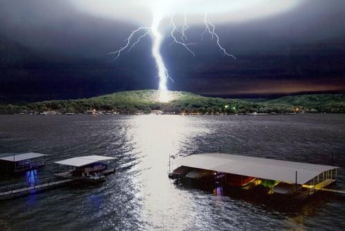
"Call Down The Sky". I have no information about who snapped this (perilously close) photo of C to G lightning. The original is at
cheezburger.com.
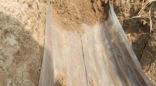
New Water Retention Technology Quenches Crop Thirst In Drought Conditions.
I keep (trying) to tell other aspiring businessmen and women that
there will be tens of thousands of new companies launched to deal with
climate change, mitigating the impacts, making cities and agriculture
more resilient in this hotter/drier/stormier environment. Here's an
innovation that may be coming to a farm near you, courtesy of
gizmag.com: "
With
climate change predicted to increase the severity and frequency of
drought events in many part of the world, water conservation is a
growing concern. New water retention technology developed at Michigan
State University (MSU) could help quench the thirst of parched crops
while using less water, not only enabling crops to better deal with
drought, but also improving crop yields in marginal areas. Coarse, sandy
soils found in semi-arid and arid regions have large pores that
absorb large quantities of rainfall. However, they retain less than 20
percent of the water in the root zone that sits between the surface
and depths of 60 to 70 centimeters (24 to 27 inches), leaching losses
of nutrients and other chemicals into ground water as the water drains
away..."
Image credit: "
The new water-saving membranes developed at MSU" (Photo: Michigan State University)
Blackberry Z10 vs. Apple iPhone 5. I like my "5",
but I'm trying to keep an open mind. How does the new smartphone from
Blackberry (you remember them, right?) stack up? Here's an excerpt of a
review from
gizmag.com: "
Pre-2007,
“BlackBerry” was practically synonymous with “smartphone.” Then the
iPhone came along ... then Android came along ... and eventually
“Blackberry” became synonymous with an inability to adapt. Now, in
2013, the company is finally doing something new. Does its first
serious multitouch handset, the BlackBerry Z10, have what it takes to take on the iPhone 5? Let’s see how their specs – and harder-to-define intangibles – compare...."
* gizmag.com has more information on a new
128 GB iPad,
set to be released next Tuesday, February 5. Ah yes, as I gaze out
over all my (suddenly obsolete) gadgets and productivity devices.
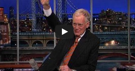
"Letterman's Top 10 Changes Coming To CNN". TVNewser has the very funny video clip. Here are Dave's suggestions (some of these could work):
10. The Situation Room now hosted by The Situation
9. Sanjay Gupta’s hilarious new sitcom: “Two Broke Guptas”
8. Changing pronunciation from C-N-N to “CNNNN”
7. Switching the part in David Gergen’s combover
6. Wolf Blitzer – shirtless
5. No longer fact-checking stories
4. New president, Jeff Zucker – Zucking everything up
3. Lifting ban on anchors using steroids
2. Piers Morgan: deported
1. More coverage of goats (video of goat attacking reporter)
An Ode to Numb. Here's a great note a winter
haiku?) I received from Barb Hollister, Guest Services Coordinator over
over at TIES in St. Paul. Here is what she wrote:
"Paul, when all those people are yelling at you about winter, remember this...
What's not to love about winter???
It is beautiful, crisp, invigorating (you're never sluggish on a cold
day), snowflakes big and small, bug free, quiet/solitude, sandwiched
between fall and spring (both gorgeous)...
It is snowmen, snow angels, skiing, sledding and skating, long (or
short depending ont he temperature) walks on crunchy snow, warm fires,
hot chocolate and lattes, great snuggling under big blankets, hot tubs,
mulled wind, ghost trees and icicles...
It's a time to work on projects, slow down, read books and rela, wear big sweatshirts and cozy sweaters...
It is character-building at times, not for the fait of heart at
times, and there are a few (perhaps just a few) of us who LOVE IT."
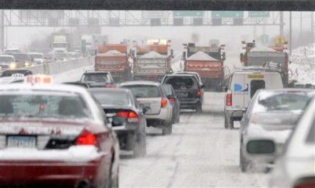
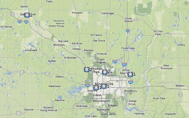
1-2" snow fell from St. Cloud into the Twin Cities Friday PM. Map above courtesy of NOAA.
Paul's Conservation Minnesota Outlook for the Twin Cities and all of Minnesota:
TODAY: Some sun early, then increasing clouds, another PM coating of snow. Winds: SW 5-10. High: 17
SATURDAY NIGHT: Flurries taper, partial clearing late. Low: 7
SUNDAY: Another clipper coating? Still chilly. High: 18
MONDAY: Plenty of chilled sun, no travel hassles. Wake-up: 8. High: 14
TUESDAY: Snow burst early, rapid clearing. Wake-up: 10. High: 28
WEDNESDAY: Fading sun, closer to average. Wake-up: 15. High: 26
THURSDAY: Mostly cloudy, brief thaw? Wake-up: 17. High: 32
FRIDAY: Blue sky, feeling better out there. Wake-up: 19. High: near 30
Climate Stories...
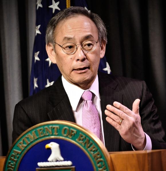
Letter From Secretary Steve Chu To Energy Department Employees Announcing His Decision Not To Serve A Second Term. Here's an excerpt from
The U.S. Department of Energy: "
The
average temperature of our planet is rising, with majority of the
temperature increase occurring in the last thirty years. During the
three decades from 1980 to 2011, the number of violent storms, floods,
droughts, heat waves, wildfires, as tabulated by the reinsurance company
Munich Re, has increased more than three-fold. They also estimate that
the financial losses follow a trend line that has gone from $40
billion to $170 billion dollars per year. Most of those losses were not
insured, and the country suffering the largest losses by far is the
United States. As the President
said in his recent Inaugural Address, “some may still deny the
overwhelming judgment of science, but none can avoid the devastating
impact of raging fires, and crippling drought, and more powerful
storms.” The overwhelming scientific consensus is that human activity
has had a significant and likely dominant role in climate change. There
is also increasingly compelling evidence that the weather changes we
have witnessed during this thirty year time period are due to climate
change..."
Photo credit above: "
U.S. Secretary of Energy Steven Chu
during an online town hall to discuss President Obama's clean energy
and innovation agenda on January 11, 2011." | Photo by Charles Watkins, Contractor, Energy Department
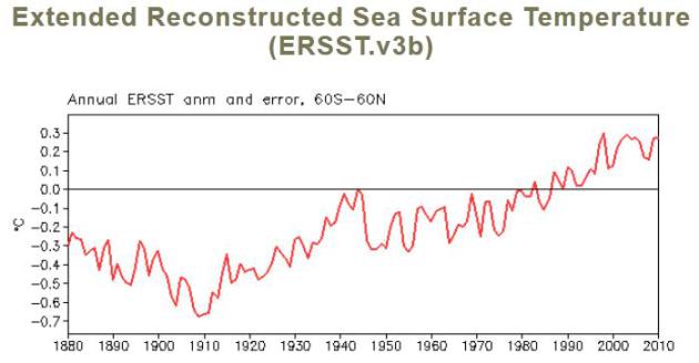
Reconstructed Sea Surface Temperature Trends Since 1880.
An estimated 90% of all warming is going into the world's oceans.
Looking only at surface (land) temperatures is the scientific equivalent
of missing the forest thru the trees. Details from
NOAA NCDC: "
Annual
ERSST.v3b anomaly from 1880-2010 from 60°S and 60°N (red solid line).
Note that the data is more reliable after the 1940's. The magnitude
of the temperature increase in recent decades is much greater than the
uncertainty in the data."
Are Human-Caused And Natural Global Warming Different? Study Says Yes.
I still get the "is this a natural cycle?" question - and I attempt to
explain that there are markers in the atmosphere now that wouldn't be
there in a natural cimate cycle. This article at
The Christian Science Monitor does a good job explaining the difference; here's an excerpt: "
Human-triggered
climate warming appears to leave a unique fingerprint on global
rainfall rates compared with natural warming, according to a new
study. The study suggests that "carbon dioxide has a fundamentally
different mode of warming than natural climate change" – one that
leaves a unique signature on rainfall rates, says Jeff Severinghaus, a
climate researcher at the Scripps Institution of Oceanography in La Jolla, Calif.
While the effect is most pronounced the the Pacific basin, the work
"is about something more fundamental.... Natural and human-caused
climate change really produce different effects.".....In general,
current climate forecasts project higher precipitation rates for the
tropics and high latitudes, with already-dry areas in the subtropics
experiencing additional drying..."
Photo credit above: "
Researchers calculate that global
warming has made heat waves in Texas (O.C. Fisher Lake in San Angelo,
Texas, is shown here) about 20 times more likely to happen during a La
Niña year. La Niñas occur when the difference in temperature between
the cooler water in the eastern tropical Pacific and the warmer water
in the west intensifies." Tony Gutierrez/AP/File.
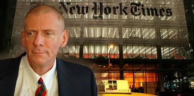
New York Times Reporter Urges Greater Climate Awareness. Here's an excerpt of a story from
The Bangor Daily News: "
Justin
Gillis says people should demand more from the media and politicians.
The New York Times reporter spoke Tuesday night at College of the
Atlantic about the issue of climate change, the topic he has covered for
the paper for the past couple of years. Gillis writes the newspaper’s
Temperature Rising series which, according to the Times’ website,
focuses “on the central arguments in the climate debate and examines the
evidence for global warming and its consequences.” Gillis told an
audience of about 80 people gathered Tuesday night at COA’s Gates
Center that the issue of climate change has been hotly debated in
recent years but poorly understood. The public needs to demand more
action from their governmental leaders on the issue, he said, and it
needs to demand better coverage of the issue from the media..."
Image above:
Media Research Center.
An interview with Gillis in the Columbia Journalism Review is
here.
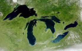
New Report Shows Comprehensive View of Climate Changes' Effect. Here's an excerpt of an article at
michiganradio.org: "
A new report from the National Wildlife Federation
details ways climate change is affecting the Great Lakes states,
including Michigan. The report says there’s more heavy rainfall events,
a major decline in ice cover, and warmer average water temperatures.
It outlines a number of examples where wildlife and communities are
reacting to the changes....The report says ice cover of the Great Lakes
in the winter has declined 71-percent on average. The reports say
that’s left coasts more vulnerable to erosion and led to higher water
evaporation rates. More water evaporation has led, in part, to lower
lake levels and an increase in lake effect snowfall. Another change for
the Midwest is warming water temperatures. The report says Lake Superior is one of the fastest warming lakes in the world.
Warmer water temperatures could improve habitat for warm water fish
like smallmouth bass and bluegill but hurt cold water species like
northern pike and whitefish...." (Image above: NOAA).
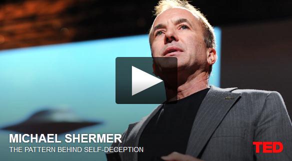
What Is Skepticism Anyway? Here's an excerpt of a TED Talk (and video) on how we reason, and the origins of skepticism, from
Huffington Post: "
As
the publisher of Skeptic magazine I am often asked what I mean by
skepticism, and if I'm skeptical of everything or if I actually believe
anything. Skepticism is not a position that you stake out ahead of
time and stick to no matter what. Consider global warming: Are you a
global warming skeptic? Or are you skeptical of the global warming
skeptics? In this case, I used to be a global warming skeptic, but now
I'm skeptical of the global warming skeptics, which makes me a global
warming believer based on the facts as I understand them at the
moment. The "at the moment" part is what makes conclusions in science
and skepticism provisional..."
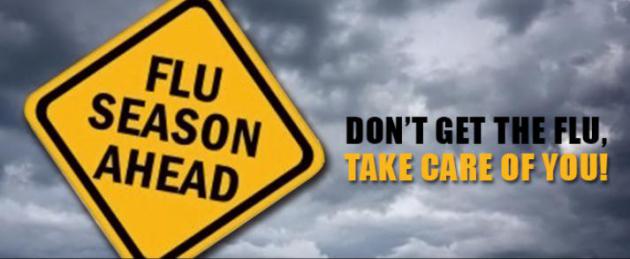
Global Warming Linked To Worse Flu Seasons. Here's an excerpt of a story at
UPI: "
Climate
change will add earlier and more severe flu seasons, U.S. researchers
say. Study leader Sherry Towers, a research professor at Arizona State
University, studied waves of influenza and climate patterns in the
United States from the 1997-98 season to the present. The research team
said data from the Centers for Disease Control and Prevention indicate
a pattern for both A and B strains: Warm winters were usually
followed by heavy flu seasons. "It appears that fewer people contract
influenza during warm winters, and this causes a major portion of the
population to remain vulnerable into the next season, causing an early
and strong emergence," Towers said in a statement..."
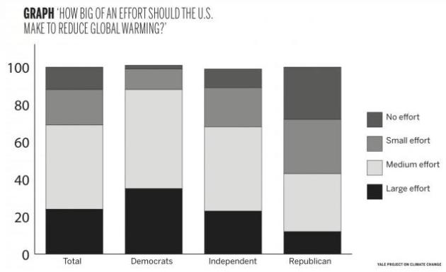
Yale Report Shows Nation Favors Action On Climate Change. Here's the intro to a story at
The Yale Daily News: "
Americans
are paying more attention to climate change, according to a Yale
report released earlier this month. The majority of Americans want the
United States government to take action against climate change and
will consider candidates’ stances on the issue when casting their
vote, according to a Jan. 15 report by the Yale Project on Climate
Change Communication. This YPCCC report, called “The Political
Benefits to Taking a Pro-Climate Stance in 2013,” shows that 88
percent of Americans overall — including 72 percent of Republicans —
believe that the United States should make at least a small-scale
effort to reduce global warming. Reflecting a September 2012 survey,
these record-breaking numbers are part of a steady upward trend in
public support for action on climate change. But perhaps more
importantly, this study shows that the stance of independent voters
toward global warming is changing, said YPCCC Director Anthony
Leiserowitz..."
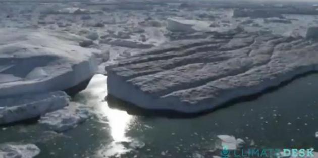
Climate Desk Live: Can Greenland Be Saved? It's worth your time to check out this
3:58 YouTube clip from Climate Desk Live: "
Glaciologist Jason Box describes a post-warming world that you won't even be able to recognize."
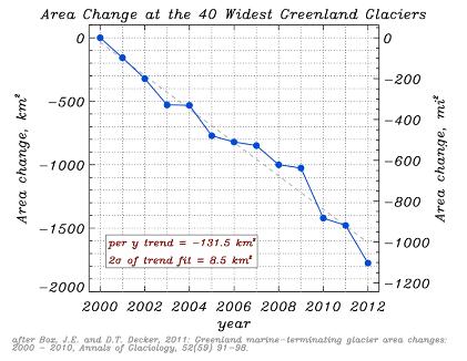
Humans Have Already Set In Motion 69 Feet Of Sea Level Rise.
Hype? Alarmism? I sure hope so. But it might be short-sighted to
totally discount one the glaciologists focused on tracking ice loss in
Greenland and Antarctica, featured in this
Mother Jones article; here's an excerpt: "
Last week, a much discussed new paper
in the journal Nature seemed to suggest to some that we needn't worry
too much about the melting of Greenland, the mile-thick mass of ice
at the top of the globe. The research found that the Greenland ice
sheet seems to have survived a previous warm period in Earth's
history—the Eemian period,
some 126,000 years ago—without vanishing (although it did melt
considerably). But Ohio State glaciologist Jason Box isn't buying it. At
Monday's Climate Desk Live briefing
in Washington, D.C., Box, who has visited Greenland 23 times to track
its changing climate, explained that we've already pushed atmospheric
carbon dioxide 40 percent beyond Eemian levels. What's more, levels
of atmospheric methane are a dramatic 240 percent higher—both with no
signs of stopping. "There is no analogue for that in the ice record,"
said Box..."
Kerry Could Spearhead Bilateral Climate Change Agreements. Here's a snippet from an article at
MIT Technology Review: "...
The
nomination of John Kerry, who was confirmed as secretary of state
this week, is certainly in line with a push for climate change action.
Kerry has long spoken out about climate change, and he led the failed
effort to pass climate legislation in the Senate in 2010, after the
House had passed its own version. As secretary of state, it’s possible
that Kerry will spearhead international climate change agreements.
Efforts at worldwide agreements have failed, but some proponents of
climate change treaties are making the case that limited agreements,
such as one between the U.S. and China, two of the world’s largest
emitters of carbon dioxide, could have a big impact on emissions.
Speaking at an energy innovation conference in Washington DC this week,
Environmental Defense Fund president Fred Krupp said, “I’m not
optimistic that we’re going to have some Copenhagen-like multilateral
agreement. But I do think there’s a chance of some bilateral agreements
with John Kerry as secretary of state...”


Istarted to feel about why "Jane Eyre"Permit touched,set it down - herindependent Dog leashes
ReplyDelete