37 F. high in the Twin Cities Monday.
32 F. average high on February 25.
28 F. high on February 25, 2012.
7" snow on the ground.
-2.9 F. February temperatures are nearly 3 F. colder than average, to date.
No major storms in sight. No big warm fronts, either.
Around The Corner
You'll rarely hear the expression "spring is
right around the corner!" in Minnesota. It's less of a corner - more of
an isosceles triangle or hexagon. We limp from slush to mud to hope. But
it's almost always two steps forward, one step back.
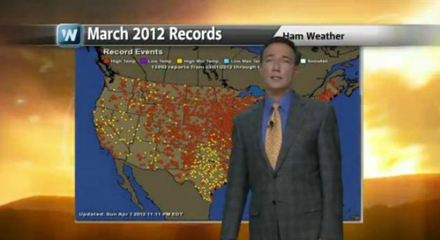
March 2012 was an aberration, a fluke. Flowers
in full bloom, after a freakish run of 60s, 70s & 80s. Almost 14,000
warm USA weather records. Exactly what climate scientists were
predicting for Minnesota...in the year 2090.
In 2013 there's more snow on the ground, a
negative phase of the NAO (North Atlantic Oscillation) spinning up big
storms, keeping mild Pacific winds from sweeping inland. I suspect a
late spring this year, which may, ironically, bode well for easing our
drought by May.
The same storm that dumped 1-2 FEET of snow on
the Texas Panhandle clips Chicago with 6-8" today, but no storms are
brewing for Minnesota thru next week, just a run of low to mid 30s.
Don't pack away the coats just yet; models are hinting at a numbing front the second week of March.
Higher Sun Angle. We've picked up 2 hours and 15 minutes of additional daylight since December 21 in the Twin Cities.
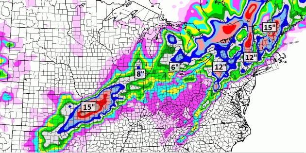
Snowfall By Midnight Thursday. Kansas City is
getting smacked (again), as much as 12-15" in the suburbs. The storm may
dump 6-10" on the Chicago area, as much as 6" in the Detroit area. As
much as 6-12" of snow may fall from Pennsylvania into interior New
England.
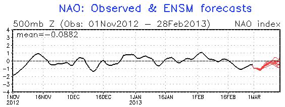
Negative Phase Of NAO. The North Atlantic
Oscillation has been negative for roughly 1 week, meaning a greater
potential for Canadian air to surge south into the USA. Strong positive
phases correlate with a strong zonal flow from the Pacific (what we
experienced last March when the USA saw record-shattering heat). A
negative phase of the NAO correlates with stormier, colder weather,
especially east of the Rockies. A negative phase of the NAO is expected
to linger into mid-March. No early spring this year, at least not for
Minnesota, the Upper Midwest, and most northern cities of the USA.
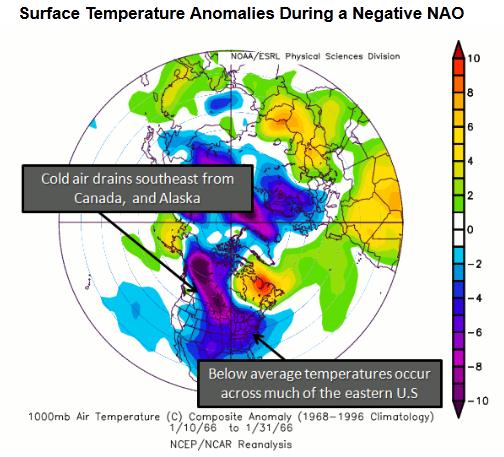
NAO: Negative Phase. This graphic from NCEP/NCAR
shows average temperatures anomalies of a negative phase of the NAO,
Canadian air making a straight shot at the USA; more waves (dips and
bulges) in the jet stream, capable of pulling polar air south, spinning
up major storms in the process.
2012 and 2013: Meteorological Apples and Oranges.
Last year at this time snow was on the ground over only 23% of the USA,
with a powerful west to east wind flow, zonal winds from the Pacific,
which warmed us up into the 70s and 80s in March. Nearly 14,000 heat
records in March 2012, a taste of early summer in late winter! Don't
expect a rerun this year. A negative phase of the NAO (North Atlantic
Oscillation) is keeping mild, Pacific air from sweeping across North
America - I expect a parade of cold fronts well into March. But this may
be a good thing (in terms of the drought). A more vigorous north-south
temperature contrast may set the stage for more vigorous storms, capable
of pulling moisture out of the Gulf of Mexico, helping to ease the
drought, especially over the Midwest. Details on
today's climate overview: "
Meteorological
spring starts Friday, March 1st, but for most of the nation it will
still look and feel like winter. Have you seen Amarillo, TX today?
This is a sharp contrast from a year ago. Meteorologist Paul Douglas
looks back at the record busting heatwaves last March and explains why
he's not expecting a repeat this year."
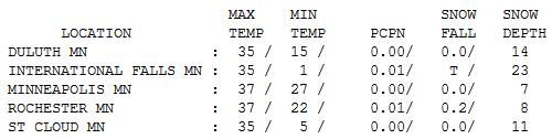
Not Bad For A Monday. After a gray start the sun
came out and in spite of snow on the ground temperatures responded to a
higher sun angle (as high in the sky as it was in mid-October), reaching
mid 30s over much of Minnesota. Snow on the ground ranges from 23" at
International Falls to 14" Duluth, 11" St. Cloud and 7" in the Twin
Cities.
"
Sun Pillar". From Steve Burns, who writes: "
My girlfriend snapped this photo with my camera as we were driving back from Madison last evening. Brilliant sunset with this sun pillar
shooting up and lighting up the clouds for quite a while! This was on
I-94W near Eau Claire. Photo credit goes to Keeley Kaziukewicz!"
Paul's Conservation Minnesota Outlook for the Twin Cities and all of Minnesota:
TODAY: Mix of clouds and sun. Winds: NE 8. High: 34
TUESDAY NIGHT: Partly cloudy. Low: 23
WEDNESDAY: Partly sunny, hints of March in the air. High: 36
THURSDAY: Patchy clouds, warmer than average. Wake-up: 22. High: 34
FRIDAY: Holding pattern, hello March! Wake-up: 19. High: 31
SATURDAY: Sun dimmed by mid/high clouds. Wake-up: 15. High: 29
SUNDAY: Some sun, a bit milder again. Wake-up: 16. High: 33
MONDAY: Clouds increase. Probably dry. Wake-up: 20. High: 32
Climate Stories...
Long Term Climate Change Trends Worry Experts. Here's a clip from a story at
Indiana Public Media: "...
Indiana
University Professor of Atmospheric Science Sara Pryor is a lead
author of the section that looks at how climate change could affect the
Midwest, specifically. She says farmers could see future crops hurt by
droughts similar to the ones the region saw last summer. “Both corn and
soybean yields are decreased if we have warm summers, and if we have
dry summers,” she says “So, given that our climate change projections
are that the Midwest will become warmer and dryer in the summer, we
certainly have expectations that crop yields will decrease.” She says if
current trends continue, the growing region for crops will move
gradually north. “Because our region is relatively flat, for one degree
of warming, a crop has to move; all plants have to move, about 100
kilometers to keep at that same temperature.” However, she says, the
farther north in the Midwest you go, the worst the soil quality gets..."
Can NASA Stop Global Warming? I'm skeptical that any
technology can stop the warming altogether, although we may be able to
launch solutions that slow the rate of warming. Here's an excerpt from
Project-Syndicate: "...
Obama
should challenge NASA to address one of today’s most important issues,
global warming, by developing safe, cost-effective technologies to
remove carbon dioxide from the planet’s atmosphere and oceans. This
mission could be accomplished in two phases.During the first phase,
which could be completed by 2020, researchers would identify roughly
10-20 candidate geo-engineering technologies and test them in
small-scale experiments. The second phase would include large-scale
test demonstrations to evaluate the most promising technologies by
2025. Developing these technologies is crucial, given that, over the
last half-century, the concentration of CO2 in the atmosphere has
increased from roughly 320 parts per million to almost 400 parts per
million, heating up the planet and increasing the acidity of the
world’s oceans. At this rate, the concentration of CO2 in the
atmosphere will exceed 450 parts per million in roughly 25 years..."
Climate Change Is Cutting Humans' Work Capacity.
Climate Central has the story; here's an excerpt: "
It’s not just the heat, it’s the humidity that gets you. That’s the conclusion of a new study
that finds climate change has reduced humanity’s ability to work by
making the planet hotter and muggier. That one-two punch has already cut
the world’s working capacity by 10 percent since humans began burning
large amounts of oil, gas, coal and other fossil fuels at the start of
the Industrial Revolution, found the analysis, which was published
Sunday in the journal Nature Climate Change. Researchers at the National Oceanic and Atmospheric Administration
predict that dive will continue, reshaping daily life in the most
populated areas of the planet as climate change intensifies.
By 2050, a
combination of rising heat and humidity is likely to cut the world’s
labor capacity to 80 percent during summer months — twice the effect
observed today..."
Heat Stress From Global Warming Reduces Labor Efficiency: Study. Here's a clip from
Raw Story: "...
The
study, published in the journal Nature Climate Change, uses a computer
model that simulates warming and a rise in humidity and their impact
on strenuous outdoor activity. The most vulnerable regions are the
Arabian peninsula, the Indian sub-continent, Southeast Asia, northern
Australia and the greater Caribbean region, including the lower
Mississippi Valley, according to John Dunne of the US National Oceanic
and Atmospheric Administration’s Geophysical Fluid Dynamics Laboratory..."


No comments:
Post a Comment