34 F. high in the Twin Cities Sunday.
57 F. average high on April 14.
73 F. high on April 14, 2012. Yes, a year ago it was nearly 40 degrees warmer. Surreal.
.37" rain fell yesterday.
3" snow left on the ground at KMSP.
Weather Whipsaw
The question comes up frequently, and it's a
good one. "How could this winter be so radically different than last?"
Polar opposites. But we've been living thru some amazing extremes in
recent years: 145 tornadoes in Minnesota in 2010 (most in the USA), a 7
month flood on the Missouri River ni 2011, followed one year later by
the warmest year on record and the worst drought since the mid-50s. One
extreme to the next.
A warmer, wetter atmosphere worldwide is
flavoring all weather now, allowing weather to get "stuck": longer,
deeper drought, floods, record heat, even prolonged chill and snow.
A
2012 paper
published at Cornell links record Arctic melting last fall with changes
in the "polar vortex", reducing the winds that swirl around the North
Pole. "What goes on in the Arctic remotely forces our weather patterns
here" said Dr. Charles Green.
The Arctic is the canary in the coal mine - a
75% drop in ice volume in 40 years may be having a domino effect at more
southerly latitudes, including Minnesota and the northern tier of the
USA this "spring".
"What’s happening now is that we are changing
the climate system, especially in the Arctic, and that’s increasing the
odds for the negative "AO" (Arctic Oscillation) conditions that favor
cold air invasions and severe winter weather outbreaks."
Global warming implies steady warming, worldwide. Global Weirding better describes what we are seeing.
The next storm soaks us with rain Wednesday, maybe ending as wet snow Thursday, but not as much drama as last week.
50s return next week; a few 60s last week of April. Hurry up spring.
The Winters Of Our Discontent: Loss of Arctic Sea Ice Is
Stacking The Deck In Favor Of Harsh Winter Weather In The U.S. And
Europe. Here's an excerpt/description of the Greene/Monger Cornell paper referenced above at
Scientific American: "
The
past three winters in parts of North America and Europe were unusual.
First, during the winters of 2009–2011, the eastern seaboard of the
U.S. and western and northern Europe endured a series of exceptionally
cold and snowy storms—including the February 2010 “snowmageddon” storm
in Washington, D.C., that shut down the federal government for nearly a
week. Later that year, in October, the NOAA Climate Prediction Center
(CPC) forecasted a mild 2010–2011 winter for the eastern U.S., based on
a La Niña pattern of cooler than usual ocean temperatures in the
eastern Pacific. But even with La Niña's moderating effects, very low
temperatures and record snowfalls hit New York City and Philadelphia in
January 2011, catching the CPC and other forecasters by surprise. More
details on his research:
- Global warming has increased the loss of summer sea ice in the
Arctic, which has altered atmospheric conditions that influence winter
weather in the U.S. and Europe.
- The changes lead to invasions of Arctic air into the middle
latitudes, increasing the likelihood of severe winter outbreaks, which
occurred in the eastern U.S. and northern Europe in 2010 and 2011 and
in eastern Europe in January 2012.
- The deck may be stacked for harsh outbreaks during the 2012–2013 winter in North America and Europe.
Polar Amplification. Hey, I expect you to be
skeptical. Changes in the Arctic having an impact on Minnesota? It does
sound a bit outrageous, but there's sound science to back up that
theory. Peter Sinclair's
Science Crocks has more details on the paper referenced above - more details on "polar amplification": "...
A
warmer Earth increases the melting of sea ice during summer, exposing
more dark ocean water to incoming sunlight. This causes increased
absorption of solar radiation and excess summertime heating of the
ocean — further accelerating the ice melt. The excess heat is released
to the atmosphere, especially during the autumn, decreasing the
temperature and atmospheric pressure gradients between the Arctic and
middle latitudes. A diminished latitudinal pressure gradient is linked
to a weakening of the winds associated with the polar vortex and jet
stream. Since the polar vortex normally retains the cold Arctic air
masses up above the Arctic Circle, its weakening allows the cold air to
invade lower latitudes..."
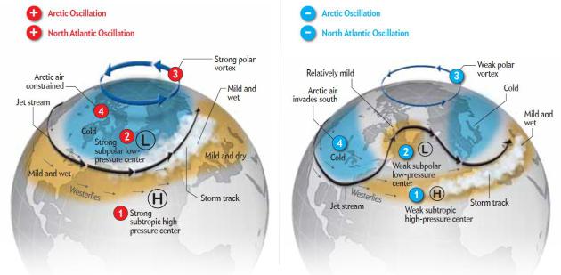
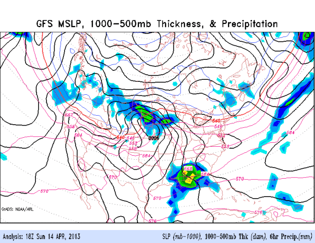
Graphic above: This winter has seen a very negative phase of
the AO, as low as -5, meaning unusually weak westerlies at far northern
latitudes, allowing polar air to become entrenched over Canada and the
northern USA. Last winter: a strongly positive phase; meaning strong
west to east winds, keeping the coldest air of winter well north of
Minnesota. What changed from year to year? Record melting of the Arctic
in September, 2012. Graphic: Greene/Scientific American.
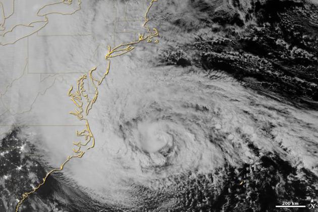
Climate Impacts On Sandy. Record melting of Arctic
ice last September helped to create an unusually warm bubble of high
pressure, an atmospheric roadblock that steering "Sandy" into coastal
New Jersey and New York - highly unusual for the end of October. Climate
scientist Charles Greene, who wrote the paper referenced above, takes a
closer look at
Scientific American. (image above: NASA Earth Observatory).
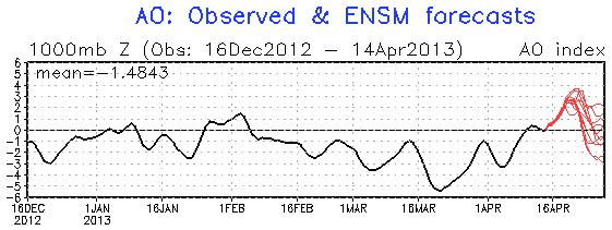
Arctic Oscillation. After being strongly negative
since early February, reaching a low point the latter half of March, the
AO or Arctic Oscillation if forecast to go positive by the third/fourth
week of April, meaning stronger west to east winds aloft, which could
just thaw out the northern USA a bit. Finally. Graph: NOAA.
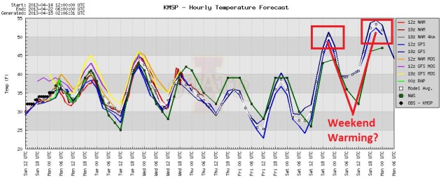
One More Marchlike Week, Then Moderation. Some of
the models are hinting at mid 40s to near 50 for the upcoming weekend.
Kind of sad when "50" is a warm front. Graphic: Iowa State.
Wet Pattern. ECMWF guidance shows a midweek
"precipitation event", starting as a cold rain Wednesday, possibly
ending as a period of wet snow Thursday - too early to know if we'll see
accumulation, but I doubt we'll pick up as much slush as last week.
Another clipper-like storm arrives Sunday-Monday; probably rain, but
some wet snow could mix in a week from today. And yes, I'm just as sick
talking about it as you are hearing about it.
No Shortage Of Storms. As mentioned up top, the
pattern is a 180 degree opposite of what we were faced with much of
2012, when the jet stream bulged north into Canada, taking most of the
moisture (and severe weather) with it. A more southerly jet will spin up
another major storm over the Plains and Midwest again this week; the
brunt of the moisture passing just east of Minnesota Wednesday and
Thursday, brushing us with a cold rain and possible wet snow by
Thursday.
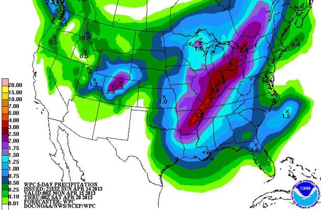
Drought-Busting Rains. NOAA's QPF 5-Day rainfall
forecasts shows some 2-4" amounts from near Little Rock to Indianapolis
and Detroit. The odds of a summer drought over the Midwest, Great Lakes
and Ohio Valley are small, and dropping daily. I still think our drought
will ease by June.
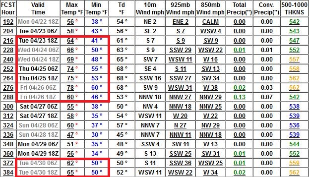
Ring The Church Bells. If that doesn't work, maybe
sound the emergency outdoor sirens? Bad idea. Shut down the city and
party in the streets? Yes. The GFS has been fairly consistent, bring a
real "warm front" into MSP the last week of April: 50s and 60s possible.
By then much of the snow may be gone, but I'm not convinced we'll see
70s, at least not yet. If we do see a sudden surge of 70s keep an eye on
the sky. As I wrote Saturday - any sharp (light-switch) warm-up could
mean a sharp north-south temperature gradient, high-velocity jet stream
winds and wind shear necessary to spin up tornadic thunderstorms.
Hopefully we see warmth without the unpleasant side-effects.
Ask Paul. Weather-related questions, comments and rants:
"
How much precipitation has Twin Cities area gotten so far in
April (and can you break out snow vs. non-snow forms) of this year? What
is normal for April precipitation. And for God's sake, please make it
stop. Thanks."
Kris Coyle
Kris - I share your sense of angst, along with pretty much every
other Minnesotan out there. Maybe there are a handful of snowmobilers
amused they can ride their sleds in mid-April, but I'm not one of them.
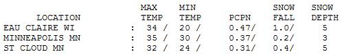
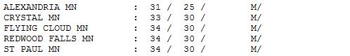
April Rainfall (MSP): 2.63" (normal rainfall is 1.11", to date. Last year only .70" rain fell as of April 14).
April Snowfall (MSP): 6.8" (normal is 1.5" - only a trace of snow fell in April, 2012).
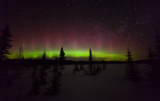
Textbook Aurora. Thanks to Steve Burns, who traveled
all the way to Voyageur's National Park to capture this stunning image
of the Northern Lights. He told me that the mercury dipped below zero at
his camp site. In mid-April? This year just keeps getting stranger and
stranger.
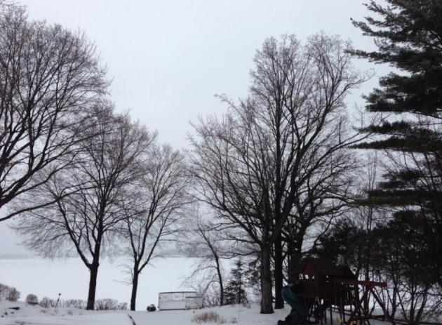
April-uary. It's the February that wouldn't end. A
coating of snow quickly changed to a cold rain yesterday, anywhere from a
third of an inch to a half inch of rain across much of the state.
Temperatures were nearly 40F colder than average.
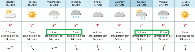
TODAY: More clouds than sun, drier, a stiff breeze. Winds: W 20. High: near 40
MONDAY NIGHT: Partial clearing. Low: 30
TUESDAY: Intervals of sun, a bit milder. High: 43
WEDNESDAY: Cold rain develops. Wake-up: 33. High: 40
THURSDAY: A little wet snow possible before precipitation tapers. Wake-up: 34. High: 38
FRIDAY: Still chilly, but drier. Some sun. Wake-up: 30. High: 40
SATURDAY: Partly sunny and breezy. Wake-up: 28. High: 45
SUNDAY: Showery rains. Wet snow north. Wake-up: 36. High: 44
* A light mix next Monday should give way to highs at or above 50F. next week. I pray.


No comments:
Post a Comment