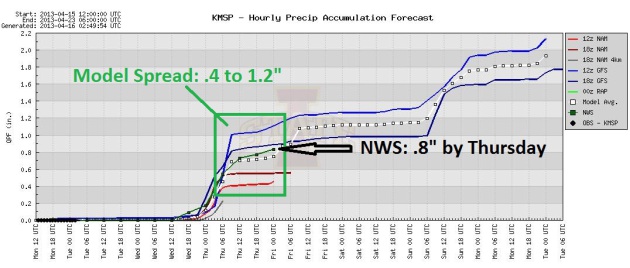
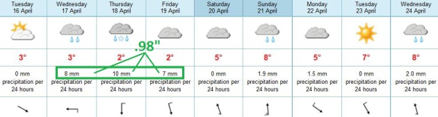
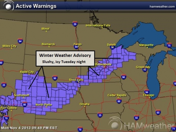
.32" precipitation predicted (starts as cold rain Wednesday afternoon - changes to wet snow Wednesday night).
1-2" slush possible Wednesday night, especially lawns and fields.
50+F temperatures by the end of next week? Models are fairly consistent. It has to warm up one of these days.
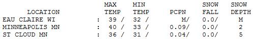
40 F. high in the Twin Cities Monday.
58 F. average high on April 15.
75 F. high on April 15, 2012.
2" snow left on the ground at KMSP.

Eye-Opening Numbers
I can't remember an April this mentally taxing
since 1983, when nearly 22" of snow delighted Twin Cities residents. I
had just arrived from Stamford, Connecticut, and I remember having a
rare "what have I done?" moment.
Weather enthusiast John Kappler forwarded a few
interesting nuggets: 3 days in the 50s so far in 2013 (warmest: 56F).
Last year we had already seen 28 days warmer than 56F. We should have
seen at least one 70-degree day so far. Since 1890 there have been only 6
years where we've failed to warm above 56F by now. More details from
John below.
I've gone on record predicting a cooler,
stormier summer for Minnesota - a gradual easing of drought conditions
(but probably more quality time in the basement, with an uptick in
severe storms, as powerful jet stream winds howl overhead). We'll see.
The next storm arrives with a cold rain
Wednesday, maybe ending as an inch or two of slush Thursday & early
Friday. Whatever falls should melt by Friday afternoon. I pray.
Long-range model guidance is pretty consistent: 50s return next week, maybe 60F by the end of next week? A "warm front"
Birds will chirp. Church bells will ring. The sirens may sound.
No, I'll never take spring for granted again.

From this data, here are some interesting facts I've gleaned about the weather this year:
• We've just had 3 days in the 50's so far this year (as of April 14).
• Our highest temperature so far this year has been 56F.
• Over the years (since 1890) we have an average of 8.1 days over 56F by now.
• Last year, we'd had 28 days higher than 56F by now.
• Normally we've had a high of 70F degrees by now (average 70.13F, median 70F)
• Since 1890, there have been only 6 years when we've failed to get over 56F by now.
Here are the years and the highest temperature reached by April 14:
1904, 55 degrees; 1950, 52 degrees; 1951, 54 degrees; 1962, 48 degrees;
1965, 54 degrees; 1975, 51 degrees. So, we have had some years like
this before, but not for almost 4 decades.
•
The most interesting of those years was 1962 when our year-to-date
high was 48 degrees. The high temperatures that year for the 12 days
beginning on April 14, were 34, 44, 48, 64, 62, 59, 60, 72, 63, 63, 84,
and 91.
•
In all of those 6 years and in all years since 1890, we managed to hit
60 by April 26. If we don't hit 60 within the next 11 days, it will be
the record for the longest we've gone into the year without hitting 60
degrees.
Thanks John!
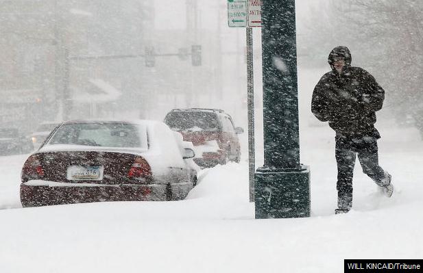
17.3" snow on April 14 (broke old record of 5" on April 14, 1986)
17.3" snow: record for most snow on any calendar day of the year in Bismarck, and it happened on April 14, 2013.
15.2" previous record for any day in April in Bismarck (set on April 5, 1997)
21.5" snow so far in April (previous record was 18.7" in 1984)
* remarkable for mid-April, the city of Bismarck has declared a Snow Emergency. Details from the Bismarck Tribune.
** photo above courtesy of Will Kincaid, Bismarck Tribune.

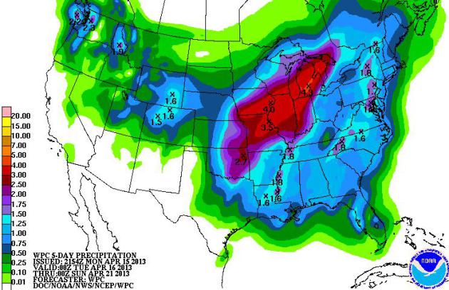


Another week - another major storm brewing for much of the USA with potential impacts on facilities and travel plans. In an effort to set expectations:
* April-uary. The maps still look like late February for much of the Rockies, Northern Plains and Upper Mississippi River Valley with more accumulating snow (less than 10 weeks from the Summer Solstice).
* Moderate risk of severe storms and large, violent tornadoes over the Southern Plains by Wednesday.
* River flooding is increasing east of the Mississippi, and the models are suggesting a very wet pattern for the eastern two-thirds of America into next week.

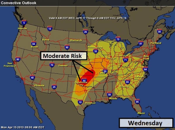
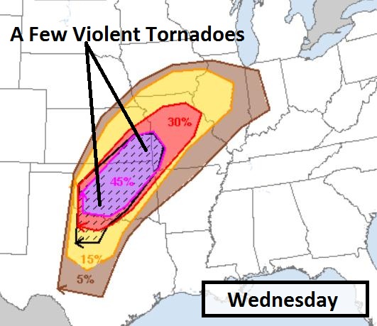
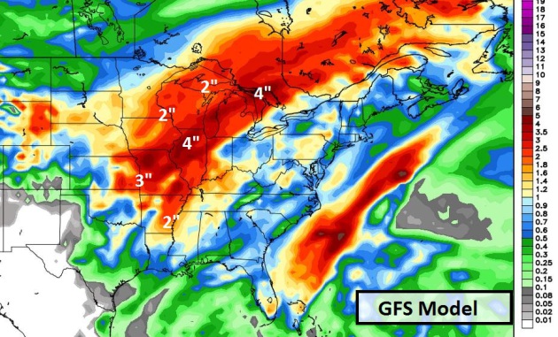
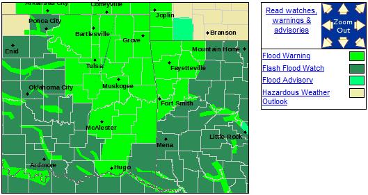
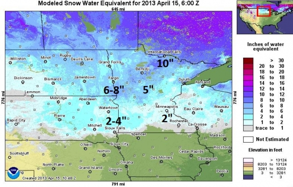
Summary: Heavy snow will impact facilities and travel plans from Colorado and Wyoming into the Dakotas this week - the Twin Cities may pick up 1-3" slushy snow Wednesday night, but whatever falls should melt by Thursday afternoon. River flooding will increase east of the Mississippi - more heavy rain in the forecast from the Midwest to the East Coast will accelerate urban/river flooding in the coming weeks. A moderate risk of severe storms over the Southern Plains means an enhanced risk of damaging winds and large, violent tornadoes from Oklahoma City to Kansas City Wednesday. We'll keep an eye on this volatile pattern and offer more updates to Alerts Broadcaster clients and prospects, as needed.

"For months, many
across NOAA have been diligently working to mitigate impacts of the
fiscal challenges of sequestration on our employees and our overall
mission. As I mentioned in previous communications, NOAA received
funding for some critical NOAA mission areas, programs and systems – but
we were still left with significant fiscal challenges due to the
mandatory across-the-board spending cuts.
Last week, I wrote to you about an initial step we took in addressing our budgetary constraints. While the hiring freeze, which went into effect March 27, was needed, it has become clear that with the implementation of the sequester cuts, it’s not enough to address our overall fiscal constraints.
Therefore, I wanted to let you know that today we are entering into national consultations with the labor unions that represent some of the NOAA workforce regarding implementation of up to four days of furlough for each NOAA employee before September 30, 2013. Our current proposal includes plans to close a majority of our offices entirely on four specific days as other agencies facing similar challenges have chosen to do. The proposal is intended to extend federal holiday weekends, when possible, which provides additional utilities and other facility cost savings. The four specific days currently in our proposal are: July 5, July 19, August 5, and August 30.
For NOAA employees who are engaged in 24/7 operations such as those who work in our Weather Forecast Offices, those working on shipboard platforms that are not at home port, law enforcement officers, and satellite operators, days will be carefully determined to ensure continuity of mission.
We will continue to provide you with information and updates as we can.
In the constrained budget environment in which we find ourselves, there are no easy or painless options available. This plan represents NOAA’s best effort to ensure that critical public services are protected and employee impacts are minimized, within the financial resources we have been given.
All of us know that this decision will affect you and your families and we urge you to speak with your managers about any concerns or suggestions you have. We are working to ensure that mission-critical or life-saving products and services are still provided.
NOAA’s employees are the backbone of our operation and the work you do day in and day out is critical to our overall mission and to overall understanding of our planet and environment. While I realize this news is difficult, we are all in this together, and I want to thank you for your dedication to this organization and our mission."
FLASH- less than an hour ago we received notice that NOAA
will furlough all employees for four days! This totally contradicts what
Secretary Blank previously told Appropriations Committee Chair Barbara
Mikulski. The Washington Post has just asked us for a comment and here
is what I provided:
"NOAA's plans to furlough operational employees at the National Weather Service as we enter the severe storm and hurricane season is unnecessary and places the public at great risk. As late as last Thursday, the House Appropriations Committee asked Acting Commerce Secretary Blank to submit a reprogramming request so that this and other cutbacks at the NWS could be avoided. The NWS has already reduced staffing at forecast offices and national forecast centers nationwide over the past two years and frozen hiring. Last month, Congress added an extra $17 million to the NWS budget this fiscal year to mitigate sequestration impacts on personnel. Most of the NWS employees being furloughed are designated "emergency essential" who, because of their public safety responsibilities, would normally be required to work during any government-wide shut-down. Why they are being furloughed when Congress has indicated it is willing to approve a reprogramming request is mind-boggling stupid."
"NOAA's plans to furlough operational employees at the National Weather Service as we enter the severe storm and hurricane season is unnecessary and places the public at great risk. As late as last Thursday, the House Appropriations Committee asked Acting Commerce Secretary Blank to submit a reprogramming request so that this and other cutbacks at the NWS could be avoided. The NWS has already reduced staffing at forecast offices and national forecast centers nationwide over the past two years and frozen hiring. Last month, Congress added an extra $17 million to the NWS budget this fiscal year to mitigate sequestration impacts on personnel. Most of the NWS employees being furloughed are designated "emergency essential" who, because of their public safety responsibilities, would normally be required to work during any government-wide shut-down. Why they are being furloughed when Congress has indicated it is willing to approve a reprogramming request is mind-boggling stupid."

Photo credit above: "Maserati has partnered with Italian furniture manufacturer Zanotta, to create a limited-edition line of armchairs." (photo: Edoardo Campanale/Gizmag)


TODAY: Peeks of sun, more tolerable. Winds: NW 10. High: 43
TUESDAY NIGHT: Partly to mostly cloudy. Low: 33
WEDNESDAY: A cold rain develops. High: near 40
WEDNESDAY NIGHT: Changeover to wet snow possible - couple of inches of slush on lawns and fields? Low: 32
THURSDAY: Wet snow tapers to flurries - clouds linger much of the day. High: 38
FRIDAY: Clouds give way to partial clearing. Wake-up: 31. High: 41
SATURDAY: Partly sunny skies. Wake-up: 27. High: 44
SUNDAY: Milder, passing shower or two. Wake-up: 35. High: near 50
MONDAY: Passing shower, chilly breeze. Wake-up: 33. High: 42
** "Fire and Ice" image above courtesy of Steve Burns.
Climate Stories....

FOOD
Taxpayers subsidize the federal crop insurance program that was created during the 1930s Dust Bowl to protect farmers against crop losses. Today, we’re experiencing another devastating drought, and federal crop insurance losses have tripled in the past three years to $16 billion in payouts for 2012..."
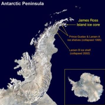
The warming has occurred in progressive phases since about AD 1460, but intensification of melt is nonlinear, and has largely occurred since the mid-twentieth century. Summer melting is now at a level that is unprecedented over the past 1,000 years. We conclude that ice on the Antarctic Peninsula is now particularly susceptible to rapid increases in melting and loss in response to relatively small increases in mean temperature..."
Photo credit above: British Antarctic Survey

Photo credit above: Heidi Roop. "This photo from December 2010 shows a one-meter long section of the West Antarctic Ice Sheet Divide core, with a dark layer of volcanic ash visible."


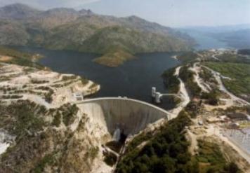
- Hydropower supplied most: Hydroelectric power supplied 37 percent of total electricity — a 312 percent increase compared to last year.
- Wind turbines broke a record: Wind energy represented 27 percent of the total share, which is 60 percent higher than last year. This is 37 percent above average and good for the highest amount generated by wind in Portugal, ever..."
No comments:
Post a Comment