Thursday, April 4, 2013

Perpectual March (heading into a wetter pattern - snowy mix next week?)

54 F. high in the Twin Cities Thursday.
52 F. average high on April 4.
62 F. high on April 4, 2012.

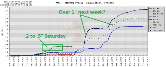
.22" rain predicted for Saturday (NAM model).

Over 1" of rain (and some wet snow) possible next week.


Perpetual March

This is a test. This is only a test. Can you keep your sense of humor, in spite of the S-word being tossed around in early April? Will you crumble under pressure, or be stoic, brave and forgiving?

It feels like The March That Wouldn't End. Before you tell me what to do with my Doppler, long range guidance is (consistently) bringing a real warm front into Minnesota the 3rd week of April, a shot at 60F after April 16. Yes, we may turn a big corner in about 10 days. In the immortal words of Dan Rather: courage.

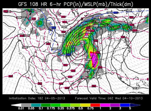
Clouds increase later today; showery rains likely tonight into Saturday. The ECMWF (European model) is wetter than U.S. models for tomorrow, hinting at .50 inches of rain. The same model shows another surge of rain arriving Wednesday & Thursday of next week, possibly mixed with wet snow north/west of MSP as a storm tracks north across the Plains. It's too early for specifics; right now I suspect it'll be just warm enough for mostly-rain.

NOAA expects the Red River to crest after April 15. A worst case scenario: sudden warmth coupled with heavy rain, accelerating snowmelt and run-off on frozen ground. We can't rule that out; Red River residents need to stay alert.

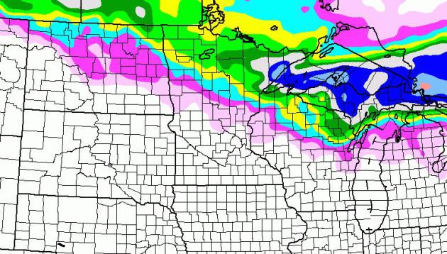
Trending Wetter. As I've been mentioning for a few days, models are hinting at a considerably wetter pattern, starting Saturday, spilling over into next week. About .2 to .5" of rain falls Saturday, but much more significant amounts are possible next week as a slow-moving storm pushes north across the Plains, fortified with moisture from the Gulf of Mexico. Graph: Iowa State.

April Snowmobiling. And cross-country skiing, and assorted snowball battles? Head up to Lake Superior's North Shore, where Saturday's storm may drop more than 4-6" of snow, with up to 8"+ over the U.P. of Michigan. Yes, I'm enjoying "spring".

Slow Motion Spring (And A Possible Winter Relapse). I'm not buying it yet, but the ECMWF is suggesting a rain-snow mix next Wednesday, changing over to mostly rain by Thursday before skies dry out by next weekend. Accumulating snow the second week of April? Not unheard of, and at the rate we're going this year nothing much would surprise me.

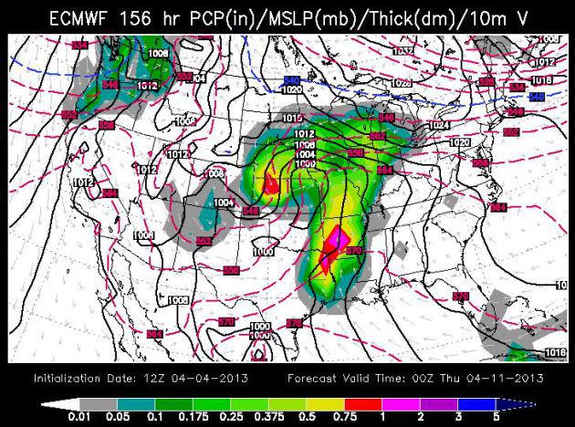
Cautious Optimism About The Drought. Will rain fall after frost entirely leaves the ground? Let's hope so, but the trends are somewhat encouraging. ECMWF guidance valid next Wednesday evening shows an intensifying storm over the Central Plains, Gulf moisture streaming north, fueling an expansive shield of rain (and some wet snow).

Hope Springs Eternal. GFS guidance shows chilly weather into next weekend, followed by moderation the third week of April, maybe a shot at 60F after April 18? I know - I'll believe it when I see it.

Red River Flooding Likely To Peak After Mid-April In Fargo-Moorhead Area, USGS Says. INFORUM has the story; here's an excerpt: "Peak flooding on the Red River in the Fargo-Moorhead metro area will likely occur sometime after April 15, according to the U.S. Geological Survey and National Weather Service. USGS stream gauges indicated that on Wednesday the Red still had not begun its spring rise. That means this year’s flood will be much later than the large floods of 2009 and 2011. This year’s flood also likely will be later than the 1997 flood, which was exacerbated by an early April blizzard, USGS predicts. “The large floods at Fargo that have previously occurred in April – 1952, 1965, 1969, 1979, and 1997 – peaked from April 15 to April 19,” said Gregg Wiche, director of the USGS North Dakota Water Science Center. “Above-normal snowpack and cold March temperatures have contributed to this year’s late melt...”

HydroClim Update. Here are a few bullet points from the latest update, courtesy of the Minnesota State Climate Office and the Minnesota office of the DNR:
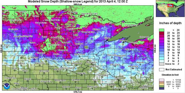
  • Snow depths range from zero in the southern one-third of Minnesota to over 20 inches west central Minnesota, north central Minnesota, and in the Lake Superior highlands.
    [see: NWS Snow Depth Estimation Map  |  Snow Depth Maps]
  • The amount of water content in the snow pack is estimated to be in excess of five inches in some west central and north central Minnesota counties. The large amount of water on the landscape, lying upon an impervious frozen surface, has led to a high risk for major flooding in the Red River basin.
    [see: NWS Snow Water Equivalent Estimation Map]
  • The U.S. Geological Survey and Minnesota DNR report that stream discharge values vary widely across the state. After the initial flush of snow melt runoff recedes, stream discharge values will quickly fall below historical medians unless there is a very wet spring.
    [see: USGS Stream Flow Conditions  |  MNDNR Weekly Stream Flow Maps and Tables]
  • Water levels on most Minnesota lakes are low due to the dry summer and autumn of 2012. Lake Superior's water level is approximately one foot lower than its historical average for this time of year.
* latest modeled snow depth from NOAA is here.

Nagging Drought Concerns. The Twin Cities metro area has picked up 4.23" of liquid precipitation (rain and melted snow) since January 1, more than half an inch above average. So the trends are encouraging - sadly, little of that moisture will do any good replenishing soil moisture, due to a thick layer of frost in the ground. We're heading into a wetter pattern, but will the storms continue after frost leaves the ground? Let's hope so. Map above showing precipitation during the last week of March courtesy of USDA.

Soil Temperatures. USDA data shows soil temperatures still in the 30s across most of Minnesota. Wheat can't develop until soil temperatures surpass 40F, corn needs consistent soil temperatures above 50F, which is still a few weeks away.

Looking Back At The April 3-4, 1974 Super Outbreak. U.S. Tornadoes has a good summary of the tornado outbreak that shocked the USA in the spring of 1974 (and helped to get me interested in meteorology). Here's an excerpt: "The “Super Outbreak of April 3-4, 1974” occurred across portions of the Midwest, Lower Mississippi Valley, and Southeast.  In what was the worst tornado outbreak of the 20th century, there were 148 tornadoes over the course of just 18 hours, almost half of which were classified as significant/strong at F2 strength or higher. Many comparisons have been made between this outbreak and the April 25-28, 2011 outbreak which featured 358 tornadoes.  Although the more recent outbreak featured many more tornadoes, they occurred over a longer time period in an age of better tornado detection, and the worst was confined to a smaller area compared to April 3-4, 1974..."

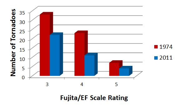
Graphic credit above: "Comparison of tornadoes F/EF3 or higher in 1974 and 2011." Chart by Kathryn Prociv.


Criticism After Sandy Leads To Changes In The Way Hurricane Warnings, Watches Are Issued. Technically, Sandy wasn't a hurricane (warm core storm) when it hit New Jersey and metro New York. NOAA discontinued Hurricane Warnings, which caused many coastal residents to lower their guard a little. Big mistake. Changes are coming, as documented in this Washington Post story; here's an excerpt: "...Under the new policy, the hurricane center in Miami will continue to put out warnings and advisories if a storm threatens people and land, even if a hurricane or tropical storm loses its name and becomes something different. “Our forecasters now have more flexibility to effectively communicate the threat posed by transitioning tropical systems,” said Louis Uccellini, the director of the National Weather Service, which is part of the National Hurricane Center. “Sandy’s forecast was remarkably accurate and under a similar situation in the future, forecasters will be able to choose the best option to underscore the urgency involved...”

The 12 Cell Phones That Changed Our World Forever. Wired.com takes a good, long walk down memory lane. Remember the "brick phone"? Oh, I was so proud to have one of these tethered to my car. What was I thinking? "Motorola engineer Martin Cooper made telecommunications history when he placed the first cellphone call 40 years ago. And who did he call, you ask? His rivals at Bell Labs, of course. Oh snap! Still, it took another decade for the mobile phone to reach the masses, because Motorola didn’t make the DynaTAC available until March 1983. And in an example of just how quaint the tech business was back then, Motorola had a press event 10 years before the phone was on sale. Which brings us to April 3, 1973, when the company that eventually brought us the Razr and Droid introduced the mobile phone. Forty years later, we’re still dropping calls like bad habits and struggling to get a signal inside a supermarket. Not that it matters, because we rarely use our phones to make phone calls. Instead, they’re a gateway to our digital lives, a means of doing everything from sending texts to updating our status to posting photos and listening to music. Thousands of phones have come and gone, and most of them seem to run on Android. But the number of handsets that could be called truly groundbreaking is surprisingly small. Here they are. Yeah, yeah, we’ve probably missed your favorite. And you’ll probably tell us about it in a comment typed on your phone....


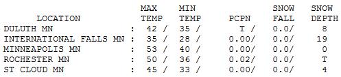
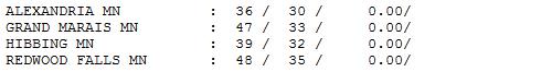
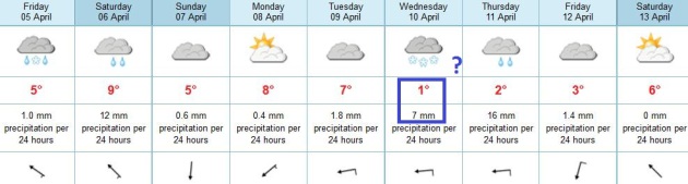
Above Average. It's getting better out there, slowly but slowly. After a gray, showery start the sun came out, highs topping 50 in the Twin Cities and Rochester with gusty northwest winds. Elsewhere highs ranged from 35 at International Falls to 45 St. Cloud.


TODAY: Sunny start, clouds increase. Winds: SE 15. High: 45

FRIDAY NIGHT: Showers develop. Low: 40

SATURDAY: Periods of rain. Soggy. High: 49

SUNDAY: Intervals of sun, a drier day. Wake-up: 35. High: 48

MONDAY: Passing shower possible. Wake-up: 36. High: 46

TUESDAY: Mostly cloudy; cool breeze. Wake-up: 32. High: 45

WEDNESDAY: MSP rain, mixed with snow north? Wake-up: 33. High: near 40

THURSDAY: Periods of rain. Wake-up: 34. High: 42

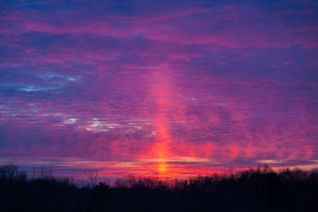
photo above: Steve Burns.

Climate Stories....


Spring Leaf-Out Comes 6 Days Earlier Than It Did In 1982. Here's an excerpt of some new research from Climate Central that caught my eye: "...The map shows that leaves are coming earlier in some parts of the country, like the Rocky Mountains and Appalachians, but that spring leaf-out has been delayed over time in parts of the Southeast, Northeast and Midwest. This is consistent with climate research that shows that many types of plants have not been blooming uniformly earlier over time. We looked at the difference between when this time arrived during the first five years and the last five years of the study. In the Minneapolis area, this date is coming about six days earlier on average since 1982. Rising temperatures may actually be behind the way this date shifts in both directions. New research suggests that the response of spring leaves to warming temperatures may not be linear, due to the effects of reduced winter chilling, and increased vulnerability to late-winter freezes. A continuing trend of warming winters may lead to further changes in the familiar timing of the seasons..."


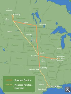
Keystone XL Stirs Montana Farmer's Climate And Crop Concerns. Huffington Post reports; here's an excerpt: ".."In terms of carbon emissions, Alberta tar sands are among the worst of the worst," said John Abraham, an engineering profesor at the University of St. Thomas. The other problem, he added, is the massive quantity of that crude oil. A study published last year in Nature Climate Change found that if all the oil in Alberta was harvested -- now only a theoretical possibility unless new technology emerges as fracking did for tapping previously hard-to-reach reserves of natural gas -- global temperatures would rise nearly 0.4 degrees Celsius (about 0.7 F), without taking into account emissions from energy used during the extraction, upgrading and refining of the heavy crude. That figure is arguably significant in the context of keeping any increase in global temperatures below the 2-degrees Celsius benchmark world leaders have agreed is critical for avoiding the most dangerous effects on the climate system. The planet has already warmed by 0.8 degrees Celsius..." (graphic: U.S. State Department).

Clouds Helped Enhance Greenland's Record Melting. Here's an excerpt of a very interesting story at Climate Central: "When scientists saw melting across a whopping 97 percent of Greenland’s icy surface last summer, they were quick to note that such an event is rare, but not unprecedented. The last time it happened was in 1889, so while manmade global warming is clearly involved it isn’t necessarily the entire story. A new new report in Nature on Wednesday has now helped flesh out the explanation: data from Summit Station, at the frozen island’s highest point, 10,551 feet above sea level, show that unusually warm temperatures in the region were enhanced by a blanket of low-level clouds that trapped extra heat from the Sun..."

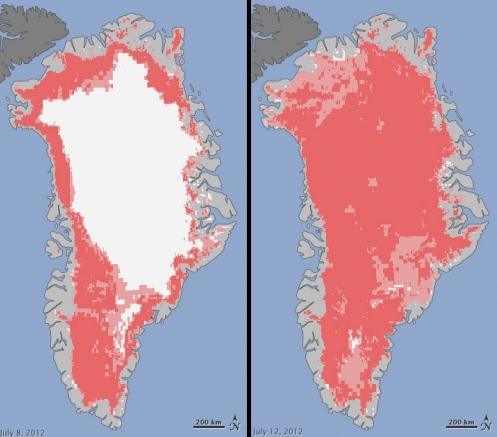
Graphic credit above: "Extent of surface melt over Greenland's ice sheet July 8, 2012 (left) and July 12, 2012 (right), melting shown in pink." Courtesy of NASA.


Economist Warns of "Radical" Climate Change, Millions At Risk. Alarmist climate hype? I sure hope so. AFP has the story - here's the intro: "The author of an influential 2006 study on climate change warned Tuesday that the world could be headed toward warming even more catastrophic than expected but he voiced hope for political action. Nicholas Stern, the British former chief economist for the World Bank, said that both emissions of greenhouse gas and the effects of climate change were taking place faster than he forecast seven years ago. Without changes to emission trends, the planet has roughly a 50 percent chance that temperatures will soar to five degrees Celsius (nine degrees Fahrenheit) above pre-industrial averages in a century, he said. "We haven't been above five degrees Centigrade on this planet for about 30 million years. So you can see that this is radical change way outside human experience," Stern said in an address at the International Monetary Fund..." (Image: NASA).

"The Whole Story Of Climate" Book Throws Climate Change A Curveball. Huffington Post has the story - here's an excerpt: "...In a fascinating new book -- The Whole Story of Climate: What Science Reveals About the Nature of Endless Change by Prometheus Books -- Peters explains how the media and politicians have distorted the facts on climate change, have come to the wrong conclusions on its causes, and have failed to prescribe real antidotes to the runaway greenhouse gases that are building up in the earth's atmosphere.

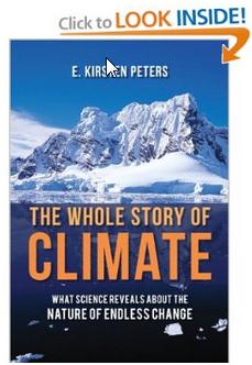
The Hype of Sustainability
Early on, Ms. Peters tears away at the misguided belief that if we develop sustainable technologies and change human behavior it will prevent the globe from "flipping" into the next Ice Age. It will not. We have delayed the latter some ticks of the geological clock, but we can't stop climate change, because that is what the earth has been doing for millions of years -- long before people walked upright..."

No comments:

Post a Comment