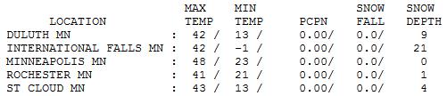
63 F. high at Canby, Minnesota yesterday;
61 F. at Madison.
48 F. high in the Twin Cities Wednesday.
51 F. average high on April 3.
64 F. high on April 3, 2012.
4.23" precipitation since January 1.
3.77" normal precipitation from January 1 - April 3.
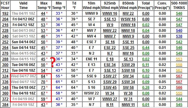
PG-rated 7-Day
"Keep your expectations low - that way you'll never be disappointed."
That certainly applies to weather, especially
this spring. Some sensitive readers may need counseling after this
forecast. Keep in mind it's a 7-Day Outlook, which is almost guaranteed
to change, as new data fuels new computer runs.
Why the pointed pangs of paranoia? Long-range
guidance is hinting at rain mixed with some wet snow up north Monday, as
a storm tracks south & east of Minnesota. A sure thing? Absolutely
not, and even if it does snow a little odds are it won't stick.
That said, April snows are especially annoying. Yes, we may experience a brush with slush early next week.
Unusual? Not really. During a typical April 2" falls on the metro - any snow usually melts within 12-24 hours. Deep breaths.
A stray shower or sprinkle is possible today as a
cooler front washes out nearby. A dry Friday gives way to showers, even
a clap of thunder Saturday as a cooler front arrives. The ECMWF is
printing out about .43" rain for Saturday. Right now I don't expect any
heavy snow on Monday, but a light mix is possible north/west of MSP.
The main storm track stays south of town next week. Long range models show 50s, even a shot at 60F by mid-April.
I'd like to be pleasantly surprised. Just once.
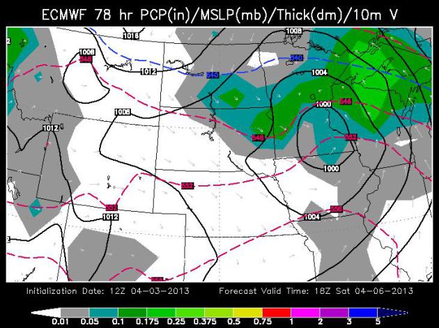
Spring Showers. The ECMWF (European) shows about
.43" rain on Saturday, which seems reasonable. We dry out Sunday,
temperatures aloft just warm enough for light rain Monday - although a
little wet snow may mix in west of MSP. Temperatures slowly moderate
next week.
Plan B Saturday. Looks like a good day for spring
housecleaning, de-cluttering the garage, rearranging your sock drawer,
maybe shopping (ugh) or seeing a movie? Saturday looks fairly wet with
4-8 hours of showers, even an isolated T-shower. ECMWF guidance above
valid midday Saturday courtesy of WSI.
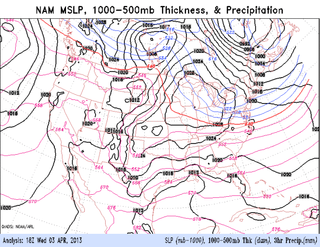
Slipping Into A Wetter Pattern? It will take months
for the drought to ease, but I'm still seeing signs that the pattern is
radically different from a year ago, and that may help to favor average
or even above average rainfall amounts in the coming months. Any rain
won't be able to soak into dusty topsoil until after the frost leaves
the ground, which is still 1-2 weeks away for the metro, considerably
longer up north. NAM model above courtesy of NOAA.
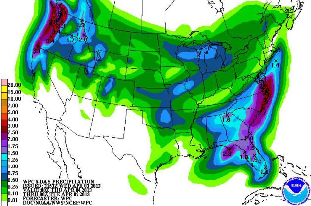
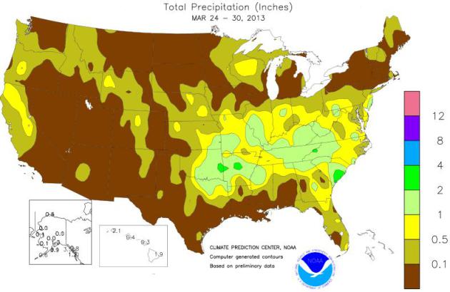
Trending Wetter. The heaviest rains over the next 5
days will be from Florida into the Carolinas and Virginia's Tidewater,
but Saturday's storm may drop some .50"+ rainfall amounts from central
Minnesota into Lower Michigan. Some 3-5" rains may spark minor flooding
over the Pacific Northwest. QPF map above: NOAA.
Atmospheric Tease? At the rate we're going I have no
idea when we'll finally warm up, but the GFS is hinting at a spell of
60s, even a few 70s, by mid-April, around April 16-18. One of these days
spring will sneak up on us, right?
Nagging Drought Concerns. The Twin Cities metro area
has picked up 4.23" of liquid precipitation (rain and melted
snow) since January 1, more than half an inch above average. So the
trends are encouraging - sadly, little of that moisture will do any good
replenishing soil moisture, due to a thick layer of frost in the
ground. We're heading into a wetter pattern, but will the storms
continue after frost leaves the ground? Let's hope so. Map above showing
precipitation during the last week of March courtesy of USDA.
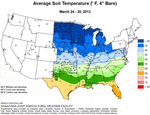
Soil Temperatures. USDA data shows soil temperatures
still in the 30s across most of Minnesota. Wheat can't develop until
soil temperatures surpass 40F, corn needs consistent soil temperatures
above 50F, which is still a few weeks away.
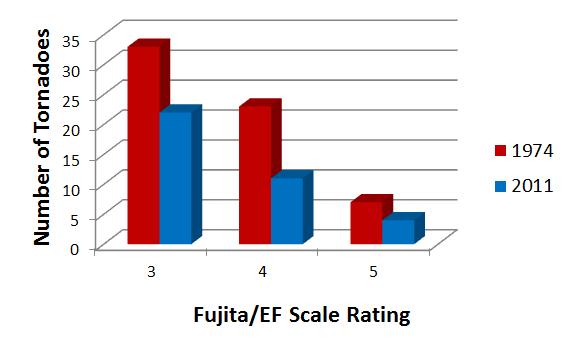
Looking Back At The April 3-4, 1974 Super Outbreak.
U.S. Tornadoes
has a good summary of the tornado outbreak that shocked the USA in the
spring of 1974 (and helped to get me interested in meteorology). Here's
an excerpt: "
The “Super Outbreak of April 3-4, 1974” occurred across
portions of the Midwest, Lower Mississippi Valley, and Southeast. In
what was the worst tornado outbreak of the 20th century, there were 148
tornadoes over the course of just 18 hours, almost half of which were
classified as significant/strong at F2 strength or higher. Many
comparisons have been made between this outbreak and the April 25-28,
2011 outbreak which featured 358 tornadoes. Although the more recent
outbreak featured many more tornadoes, they occurred over a longer time
period in an age of better tornado detection, and the worst was
confined to a smaller area compared to April 3-4, 1974..."
Graphic credit above: "
Comparison of tornadoes F/EF3 or higher in 1974 and 2011." Chart by Kathryn Prociv.
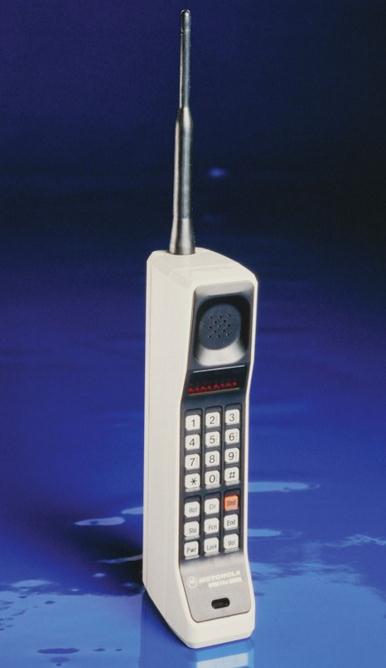
The 12 Cell Phones That Changed Our World Forever. Wired.com
takes a good, long walk down memory lane. Remember the "brick
phone"? Oh, I was so proud to have one of these tethered to my car. What
was I thinking? "
Motorola engineer Martin Cooper made
telecommunications history when he placed the first cellphone call 40
years ago. And who did he call, you ask? His rivals at Bell Labs, of
course. Oh snap! Still, it took another decade for the mobile phone to
reach the masses, because Motorola didn’t make the DynaTAC available
until March 1983. And in an example of just how quaint the tech
business was back then, Motorola had a press event 10 years before the
phone was on sale. Which brings us to April 3, 1973, when the company
that eventually brought us the Razr and Droid introduced the mobile
phone. Forty years later, we’re still dropping calls like bad habits
and struggling to get a signal inside a supermarket. Not that it
matters, because we rarely use our phones to make phone calls. Instead,
they’re a gateway to our digital lives, a means of doing everything
from sending texts to updating our status to posting photos and
listening to music. Thousands of phones have come and gone, and most of
them seem to run on Android. But the number of handsets that could be
called truly groundbreaking is surprisingly small. Here they are.
Yeah, yeah, we’ve probably missed your favorite. And you’ll probably
tell us about it in a comment typed on your phone....
Airline Lavs Shrink To Fit More Seats. Great news! Now you'll have to go on a diet just to use the bathrooms at 30,000 feet. Here's an excerpt from
The Wall Street Journal: "
Airplane
space-squeezers have been back in the lavatory – not a typo – shrinking
the space that airplane bathrooms take up. My colleague Susan Carey reports on a ground-breaking coach-cabin lavatory built
by B/E Aerospace that won over Boeing Co. and airlines because it
packs a loo into a little space and allows for a few more coach seats
on planes. Delta Air Lines Inc. will be among the first customers to
get the petite potty, and those 737-900s will have four additional
seats because of smaller lavs..."
Creeping In The Right Direction. The Twin Cities
metro was only 3 degrees cooler than average yesterday. Progress. Highs
ranged from 35 at Grand Marais to 43 St. Cloud, 55 at Redwood Falls (no
snow nearby to cool those gusty south winds).
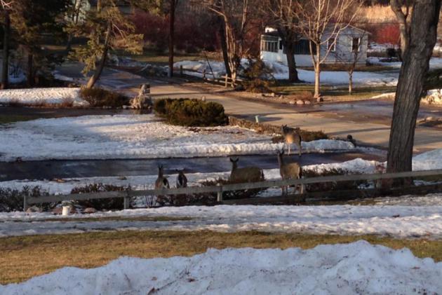
Deer Paul. Yes, those are deer in my front yard - a
lot of deer, foraging for food, eating our plants. I'm as ready for
spring as everyone else - trust me on that one.
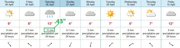
TODAY: Partly to mostly cloudy, passing sprinkle? Winds: NW 10-15. High: 48
THURSDAY NIGHT: Partly cloudy and cool. Low: 31
FRIDAY Clouds increase, showers possible by late afternoon or evening. High: 47
FRIDAY NIGHT: Showers likely, even a clap of thunder. Low: 37
SATURDAY: Few showers (best chance morning and midday), turning breezy and cooler. High: near 50
SUNDAY: Some sun. Nighttime showers. Wake-up: 32. High: 48
MONDAY: Cold rain may mix with wet snow. No accumulation expected right now. Wake-up: 33. High: 41
TUESDAY: More clouds than sun, chilly. Wake-up: 35. High: 46
WEDNESDAY: More sun. Storm stays south/east. Wake-up: 33. High: 47
Climate Stories....
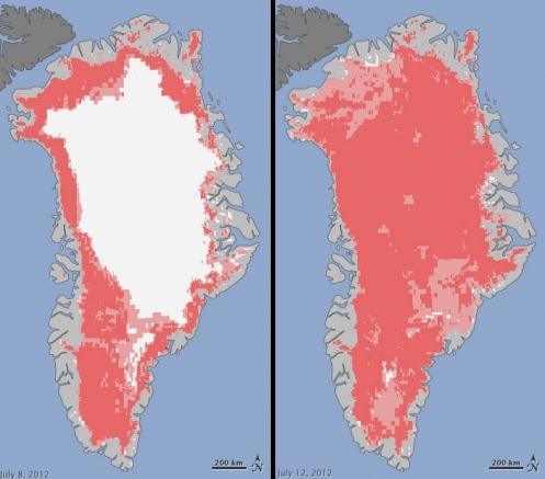
Clouds Helped Enhance Greenland's Record Melting. Here's an excerpt of a very interesting story at
Climate Central: "
When scientists saw melting across a whopping 97 percent
of Greenland’s icy surface last summer, they were quick to note that
such an event is rare, but not unprecedented. The last time it happened
was in 1889, so while manmade global warming is clearly involved it
isn’t necessarily the entire story. A new new report in Nature on Wednesday has now helped flesh out the explanation: data from Summit Station,
at the frozen island’s highest point, 10,551 feet above sea level,
show that unusually warm temperatures in the region were enhanced by a
blanket of low-level clouds that trapped extra heat from the Sun..."
Graphic credit above: "
Extent of surface melt over Greenland's ice sheet July 8, 2012 (left) and July 12, 2012 (right), melting shown in pink." Courtesy of NASA.
Economist Warns of "Radical" Climate Change, Millions At Risk. Alarmist climate hype? I sure hope so.
AFP has the story - here's the intro: "
The
author of an influential 2006 study on climate change warned Tuesday
that the world could be headed toward warming even more catastrophic
than expected but he voiced hope for political action. Nicholas Stern,
the British former chief economist for the World Bank, said that both
emissions of greenhouse gas and the effects of climate change were
taking place faster than he forecast seven years ago. Without changes
to emission trends, the planet has roughly a 50 percent chance that
temperatures will soar to five degrees Celsius (nine degrees
Fahrenheit) above pre-industrial averages in a century, he said. "We
haven't been above five degrees Centigrade on this planet for about 30
million years. So you can see that this is radical change way outside
human experience," Stern said in an address at the International
Monetary Fund..." (Image: NASA).
"The Whole Story Of Climate" Book Throws Climate Change A Curveball.
Huffington Post has the story - here's an excerpt: "...
In a fascinating new book -- The Whole Story of Climate:
What Science Reveals About the Nature of Endless Change by Prometheus
Books -- Peters explains how the media and politicians have distorted
the facts on climate change, have come to the wrong conclusions on its
causes, and have failed to prescribe real antidotes to the runaway
greenhouse gases that are building up in the earth's atmosphere.
The Hype of Sustainability
Early on, Ms. Peters tears away at the misguided belief that if
we develop sustainable technologies and change human behavior it will
prevent the globe from "flipping" into the next Ice Age. It will not.
We have delayed the latter some ticks of the geological clock, but we
can't stop climate change, because that is what the earth has been
doing for millions of years -- long before people walked upright..."


No comments:
Post a Comment