By Todd Nelson
Wet enough for ya? Not sure how much more rain my yard can take. Between the puddles and the neighbors doggie landmines, not sure I'll be playing bocce ball anytime soon.
Scattered showers and storms are in the forecast again Sunday as the storm system continues to wobble overhead, what else would you expect? Some of the isolated storms that develop later Sunday across southeastern Minnesota could be a little on the more vigorous side.
A cooler and more stable air mass moves in on the northern side of the low by Tuesday and Wednesday with mainly just lingering rain showers. I think the clouds will finally get out of here by the end of the week and you might actually be able to get out and mow that lawn if you haven't already.
I'm curious to see how the Minnesota drought will have changed after all this rain. My hunch is that many of those smaller swamps and ponds close to home will have filled up quite nicely; perfect for a fresh brood of skeeters. In no time you'll be slapping those pesky blood suckers... Welcome to Minnesota where Mosquitoes are as big as buzzards. Don't forget to check the kids for ticks if they're in tall grass or the woods!
________________________________________________________________
Todd's Conservation MN Outlook for the Twin Cities and all of Minnesota
MONDAY: Lingering shower/storm possible early AM. Breaks of midday sun, then more showers/storms develop by late afternoon/evening across southeastern Minnesota (some could be strong). High: 78. Winds: SE 10-15
MONDAY NIGHT: Showers and storms possible overnight. Low: 58
TUESDAY: Cooler. Lingering light rain showers, isolated thunder. High: 73
WEDNESDAY: Damp. Cloudy and cooler with passing showers. Wake-up: 51. High: 62
THURSDAY: Ditch the umbrellas! More sun. Wake-up: 47. High: 67.
FRIDAY: Smells of SPF return. Warmer with more sun. Wake-up: 47. High: 71.
SATURDAY: Warmer. Increasing clouds with an isolated PM shower/storm? Wake-up: 52. High: 73.
SUNDAY: Unsettled. Afternoon grilling plans may be delayed due to spotty thunder? Wake-up: 55. High: 75
__________________________________________________________________
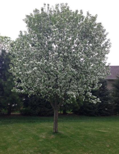
Scratch and Sniff?
Thanks to my good friend Jill Stewart Kellar for the picture below who said that she wished the picture was 'scratch and sniff' - LOL - It looks AMAZING, but it can't smell it!
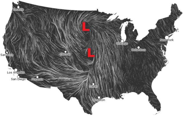
Wind Map
Here's an interesting look at wind flow across the country. Note the southerly wind flow east of the two low pressure systems. This is responsible for the warm and humid air that has been in place across the middle part of the country as of late. This has also helped set the stage for all the severe weather that we've seen over the last few days.
See the latest wind flow map HERE:
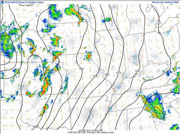
Radar From Sunday...
Take a look at how active the radar was across the middle part of the country from Minnesota to Oklahoma. At this on Sunday, there were a number of watches and warnings in progress and there had been reported tornadoes in Kansas and Oklahoma!
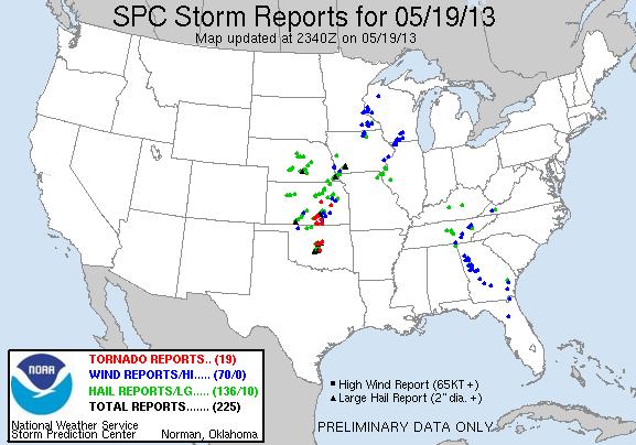
Here are a few of the storm reports from the very active Sunday across the middle part of the country.
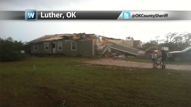
Oklahoma Damage
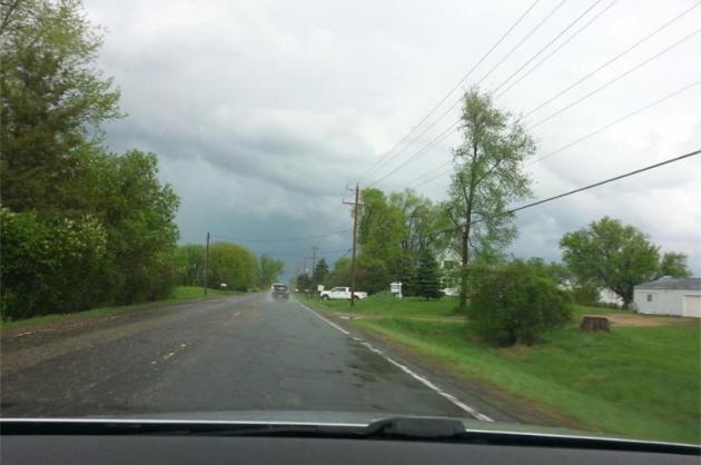
Take a look at this photo taken in Luther, OK from the Oklahoma County Sheriff's office on Sunday evening.
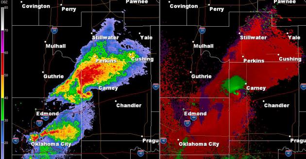
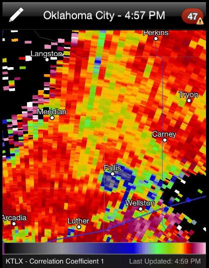
Oklahoma Tornado
It's amazing what technology can do in this day in age... Take a look at the radar image from Oklahoma Sunday evening northeast of Oklahoma City, OK near Fallis, OK. The classic "Hook Echo" with red and green close to gether on the velocity signature indicatues intense rotation.
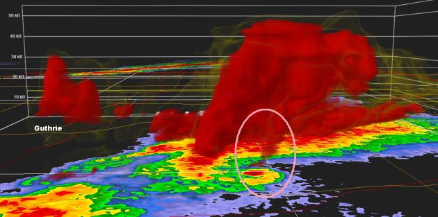
This is what it looked like in a 3D view... It's almost like you can see the tornado touching the ground!
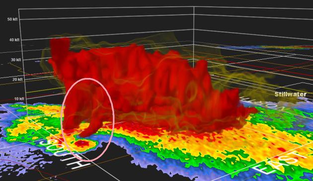
Thanks to my good friend Amy Bettwy for the picture below... in the new radar upgrade to Dual Pole Radar, you can actually see a "TDS" or a Tornado Debris Signature! In the image below, you can see a dark spot over Fallis, OK where the Dual Pole radar may actually be picking up debris vaulted high in the air!
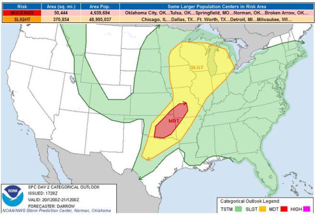
Severe Threat Continues...
The Storm Prediction Center continues the severe thunderstorm threat for Monday across the middle part of the country. Keep in mind that this threat will likely change as the storm continues to settle into the middle part of the country.
Severe Threat Monday
...SOUTHERN PLAINS TO MID MS VALLEY...
SECONDARY MID LEVEL SPEED MAX...ON THE ORDER OF 60KT AT 500 MB...IS
EXPECTED TO EJECT ACROSS THE SRN ROCKIES INTO NRN OK BY 21/00Z.
WHILE LATE DAY1 CONVECTION MAY DISTURB LOW LEVEL WIND FIELDS ACROSS
PORTIONS OF SERN KS INTO MO...IT APPEARS LARGE SCALE INFLUENCE OF
APPROACHING SPEED MAX SHOULD SHARPEN SYNOPTIC FRONT ACROSS OK BY
PEAK HEATING. THIS WILL BE THE PRIMARY FOCUS FOR RENEWED SEVERE
THUNDERSTORM DEVELOPMENT ACROSS THE MDT RISK REGION.
THUNDERSTORMS...A FEW SEVERE WITH A THREAT OF HAIL...MAY BE ONGOING
AT THE BEGINNING OF THE PERIOD ACROSS SERN KS/MO ALONG THE NOSE OF
VEERED LLJ. THIS CONVECTION MAY TEMPORARILY DISPLACE THE SYNOPTIC
FRONT OR PERHAPS EVEN PRODUCE OUTFLOW THAT BECOMES A FOCUS FOR
AFTERNOON CONVECTIVE DEVELOPMENT. STRONGEST BOUNDARY LAYER HEATING
IS EXPECTED ACROSS WEST TX INTO SWRN OK WHERE SFC TEMPERATURES
SHOULD SOAR INTO THE 90S. ALONG/NORTH OF THE MAIN MID LEVEL JET
CORE MID LEVEL TEMPERATURES SHOULD COOL SUCH THAT DEEP CONVECTION
WILL EASILY DEVELOP ALONG AFOREMENTIONED CONVECTIVE OUTFLOW BOUNDARY
INTO MO AND SHARPENING COLD FRONT/DRYLINE FARTHER WEST. IN
FACT...TSTMS MAY DEVELOP BY 20-21Z ACROSS OK WHERE SBCAPE IS
EXPECTED TO BE IN EXCESS OF 3000 J/KG. FORECAST DEEP LAYER
SHEAR...IN EXCESS OF 50KT THROUGH 6KM...AND THE PROSPECT FOR A VERY
MOIST WARM SECTOR FAVOR NUMEROUS SUPERCELL STRUCTURES...AT LEAST
THROUGH MID EVENING OF THE CONVECTIVE CYCLE. VERY LARGE HAIL AND
TORNADOES ARE POSSIBLE WITH SUPERCELLS AND WITH TIME ONE OR MORE
MCS/S SHOULD EVOLVE ALONG NOSE OF STRENGTHENING LLJ OVER OK. AMPLE
MID LEVEL FLOW WILL EXTEND ALONG THE DRYLINE INTO THE EDWARDS
PLATEAU OF TX SUPPORTIVE OF ISOLATED SUPERCELL STRUCTURES CAPABLE OF
PRODUCING AT LEAST LARGE HAIL AND DAMAGING WINDS.
...UPPER MS VALLEY/GREAT LAKES...
LATEST MODEL GUIDANCE SUGGESTS A MID LEVEL SHORT WAVE TROUGH/SPEED
MAX WILL ROTATE NEWD ACROSS IA/IL INTO MN/WI DURING THE AFTERNOON
HOURS. THIS FEATURE WILL SERVE TO INCREASE UVV ACROSS A FAIRLY
MOIST/UNSTABLE BOUNDARY LAYER SOUTH OF SHARP WARM FRONT THAT WILL
EXTEND FROM LOW NEAR THE ND/SD/MN BORDER...EWD INTO NRN WI AT PEAK
HEATING. WHILE SHORT WAVE TROUGH WILL INFLUENCE/SUPPORT DEEP
CONVECTION...STRONG BOUNDARY LAYER HEATING WILL PROVE INSTRUMENTAL
IN DESTABILIZATION ACROSS MN/WI AND SBCAPE COULD EASILY RISE TO NEAR
2000 J/KG. DISCRETE SUPERCELL STRUCTURES MAY EVOLVE WITHIN THIS
AIRMASS AND WITH RELATIVELY LOW CLOUD BASES ISOLATED TORNADOES...IN
ADDITION TO LARGE HAIL MAY BE OBSERVED.
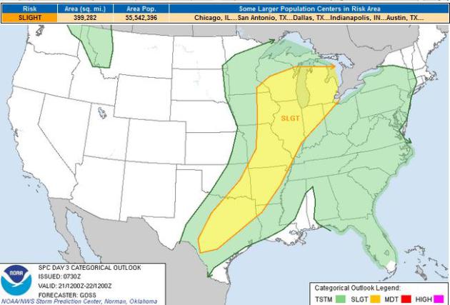
Severe Threat Tuesday
...SYNOPSIS...
SLIGHT WEAKENING/DEAMPLIFICATION OF THE LINGERING MID- AND
UPPER-LEVEL STORM SYSTEM OVER THE CENTRAL U.S. IS FORECAST THIS
PERIOD...AS A DIGGING/STRENGTHENING TROUGH/LOW SHIFTS SSEWD INTO THE
WRN/NWRN U.S. THROUGH THE END OF THE PERIOD. THE CENTRAL U.S.
SYSTEM WILL REMAIN THE PRIMARY DRIVER FOR THE MAJORITY OF THE
CONVECTIVE POTENTIAL THIS FORECAST.
...UPPER GREAT LAKES REGION SWWD INTO CENTRAL TX...
MODEL DIFFERENCES WITH RESPECT TO TIMING OF A SHORT-WAVE TROUGH
ROUNDING THE SRN PERIPHERY OF THE UPPER LOW AND WIDESPREAD
CONVECTIVE ACTIVITY DURING INTERVENING DAYS IS YIELDING FAIRLY
SUBSTANTIAL UNCERTAINTY WITH RESPECT TO DETAILS OF THE DAY 3
/TUESDAY/ SEVERE WEATHER POTENTIAL STRETCHING FROM THE GREAT LAKES
TO TX.
ATTM...IT APPEARS THAT A COLD FRONT -- MOVING ACROSS THE CENTRAL AND
SRN PLAINS AT THE START OF THE PERIOD -- SHOULD BEGIN TO WASH OUT AS
EWD PROGRESSION SLOWS INTO THE AFTERNOON. WHILE CLOUDS AND ONGOING
SHOWERS AND THUNDERSTORMS AHEAD OF THE FRONT WILL LIKELY INHIBIT
HEATING/DESTABILIZATION IN SOME AREAS INTO THE
AFTERNOON...SUBSTANTIAL DESTABILIZATION IS FORECAST BY LATE
AFTERNOON -- PARTICULARLY FROM THE SERN OK/WRN AR VICINITY SWWD INTO
CENTRAL TX AHEAD OF THE DRYLINE.
BOUNDARY-LAYER CAPPING SHOULD LIMIT DEVELOPMENT INTO THE
AFTERNOON...BUT STORM DEVELOPMENT IS EVENTUALLY EXPECTED -- WITH
COVERAGE DEPENDING TO SOME DEGREE UPON TIMING OF A SHORT WAVE TROUGH
CROSSING THE SRN ROCKIES DAY 2 AND THEN SHIFTING INTO TX DAY 3.
WITH AMPLE SHEAR AND LIKELY-TO-BE STRONG INSTABILITY ACROSS THE
ARKLATEX AND INTO CENTRAL TX...SIGNIFICANT SEVERE WEATHER --
PRIMARILY VERY LARGE HAIL -- WILL BE POSSIBLE. HOWEVER...WITH
QUESTIONS REGARDING CONVECTIVE COVERAGE/CONCENTRATION...WILL
INTRODUCE ONLY 15% SEVERE PROBABILITY ATTM.
FARTHER N -- ACROSS MO AND AS FAR NEWD AS THE UPPER GREAT LAKES
REGION...THE SCENARIO IS EVEN MORE UNCLEAR...AS MORE WIDESPREAD
STORMS ONGOING EARLY IN THE PERIOD WILL LIKELY PERSIST THROUGH THE
DAY. THEREFORE...MORE UNCERTAIN DEGREE OF DESTABILIZATION -- AS
WELL AS GENERALLY WEAKER SHEAR DUE TO MORE MERIDIONAL/UNIDIRECTIONAL
FLOW ALOFT -- SHOULD LIMIT THREAT TO SOME DEGREE. STILL...LOCALLY
SEVERE STORMS CAPABLE OF PRODUCING HAIL AND DAMAGING WINDS AND
POSSIBLY AN ISOLATED TORNADO CAN BE EXPECTED. THREAT SHOULD
DIMINISH OVERNIGHT...THOUGH STORMS/LIMITED POTENTIAL FOR SEVERE
WEATHER WILL CONTINUE THROUGH THE END OF THE PERIOD.
Minnesota Storms
Thanks to my good friend Ben Lewis for this picture out of the Twin Cities. Heavy rain and gusty winds was all he reported on what he called a "Lil Baby Chase" - LOL - Thanks Benny!!
Thanks to my good friend Ben Lewis for this picture out of the Twin Cities. Heavy rain and gusty winds was all he reported on what he called a "Lil Baby Chase" - LOL - Thanks Benny!!
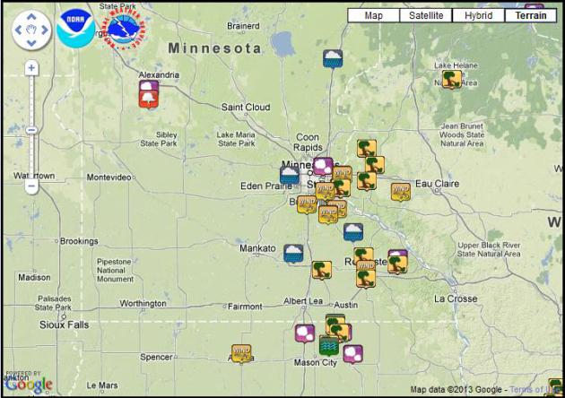
Minnesota Storm Reports
Here's some of the storm reports that were relayed to the National Weather Service on Sunday.
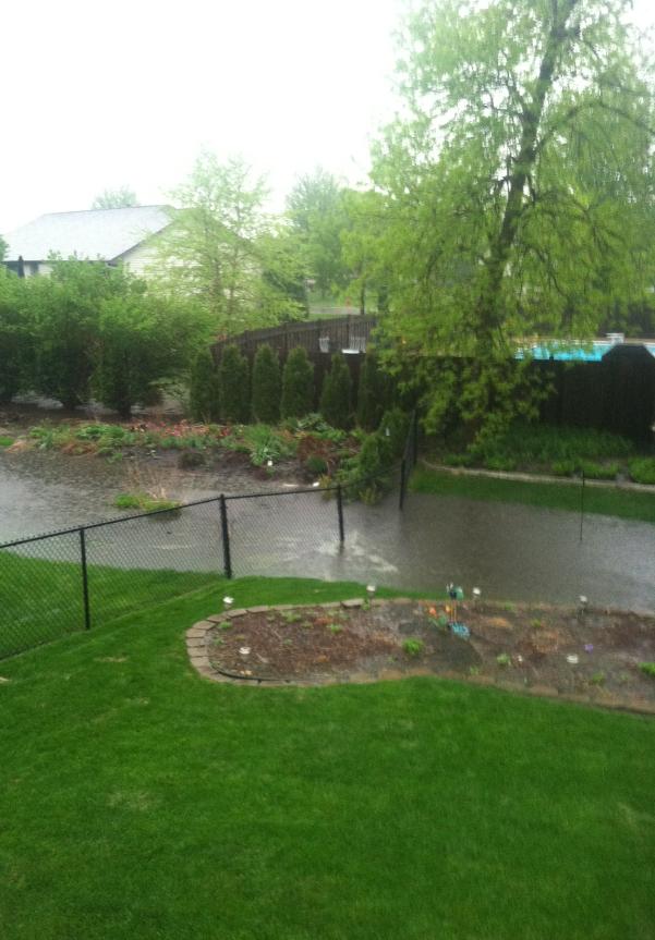
Heavy Rainfall
Thanks to my good friends
Melissa and Denny Purdy from Rogers, MN. Heavy rainfall on Sunday over
an already saturated ground created this small lake in their backyard.
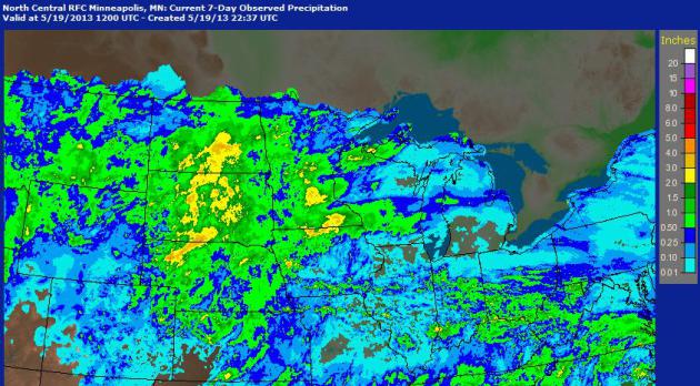
Midwest 7 Day Rainfall
Take a look at the 7 day radar
estimates of rainfall. There are several locations that have seen 1" to
4"+ of rainfall since last week. This should help with the drought
situation... It'll be interesting to see how the drought situation
changes after all this heavy rainfall!
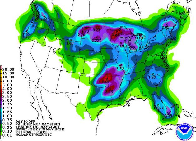
More Heavy Rain on the Way...
The same slow moving storm system will be responsible for additional heavy rainfall across the middle part of the country through midweek. There still may be additional 1" to 3"+ amount by Wednesday!
Thanks for checking in, have a great week ahead!
Don't forget to follow me on Twitter @TNelsonWNTV

No comments:
Post a Comment