Time-Shifted Weather
Overheard on Delta Flight 1301 from BWI to MSP:
"...you don't have to worry..the snow and ice has melted. I'm telling
you it's safe to visit Minnesota!" Not what you want to hear on May 20.
What a crazy spring, following a nutty 2012. In fact the last decade
has been anything but normal.
This year it's as if Mother Nature took her
remote control (the one she clubs us over the head with) and
time-shifted spring 3-6 weeks later than usual.
It's been a mixed blessing. The same jet stream
dips and bulges that kept us cold & snowy much of spring also
pumped Gulf moisture north. The drought is pretty much over in the
metro; easing rapidly over central & western counties. These jabs
of chilly air are so strong they can cut off from the main jet stream -
stalling, spinning like a giant land-hurricane; spiral spokes of
moisture rotating around a giant wheel of low pressure stuck over the
Plains.
Instability pop-up showers hang on into
Wednesday; heavier T-storms Friday. Just enough dry Canadian air pushes
south for comfortable sun much of the holiday weekend. Monday looks
like the best day for the lake: highs 60s north to low 70s south.
A respectable Memorial Day? Hey, it's safe!
Tornado Nation. We've turned
tornado spotting and tornado chasing into something of a sport in this
country. Who will get the "money shot" and maybe make a few thousand
dollars selling his iPhone video to the local TV station or national
weather channel? Last night the reality of tornadoes came into full
view. Nature's deadliest wind swept into Moore, Oklahoma, 200 mph winds
for 3-6 minutes, and the results were devastating. This EF-4 or EF-5
tornado will probably go down into the record books as the costliest
tornado in U.S. history. The loss of life was horrific. As
meteorologists we're trained to be clinical as we track and predict all
kinds of life-threatening weather. But as a father and human being, you
couldn't watch last night's coverage without your heart breaking.
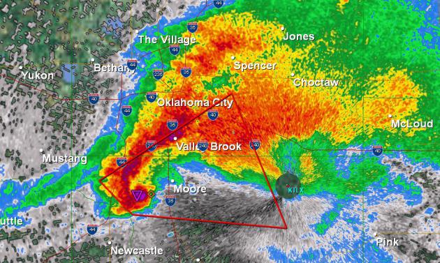
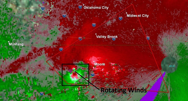
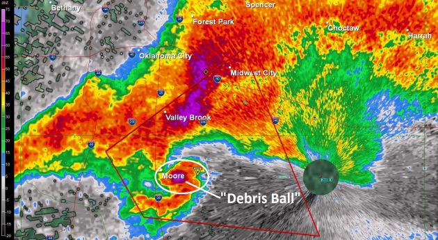
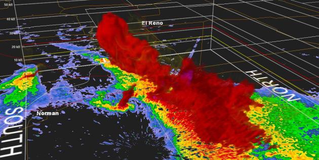
Classic Hook Echo. If you see
something like THIS on Doppler you know you have a large, potentially
violent tornado. This NWS Doppler (reflectivity) image was taken 10
minutes before Moore suffered a direct hit. The Chief Meteorologist at
KFOR-TV in Oklahoma City actually told his viewers "if you don't have a
basement you will not survive a direct strike from this tornado -
better to get into your vehicle and try to drive away". You don't hear
that very often.
* fewer than 1 in 10 Oklahomans have a basement.
The reason? Bedrock. It's cost-prohibitive to put in a basement across
most of the Sooner State.
* last year I wrote an article for Huffington Post,
highlighting a prolifice, well-respected structural
engineer/meteorologist who predicts that, within our lifetime, America
will be struck by a single urban tornado that claims over 1,000 lives.
My jaw dropped when I heard him say this, but after yesterday I'm
starting to think he was right.
Lessons From Moore.
There's nothing we can do to stop these terrifying storms, but you can
take steps to better prepare. For years I've been talking about
"multiple safety nets"; the more sources of tornado information, the
better. That means media, social media, e-mail alerts, sirens,
NOAA Weather Radio and apps for your smartphone. Details:
2). Situational Awareness.
Any good camper can read the sky and (on some level) know if a severe
storm is brewing. High humidity, a southeast breeze, building clouds
are all tip-offs that storms may be brewing. Wherever you are, hiking,
camping, enjoying the outdoors, always have an "escape route" in the
back of your mind. Where could you seek shelter if skies turn
threatening? Under a rocky overhang, a nearby store or lodge? With a
little planning and a Boy Scout "be prepared" mindset you can lower the
risk of disaster by thinking and planning ahead.
3). Smartphone apps.
This is where the real revolution is taking place in warning
technology. There are some terrific apps out there for getting the
time-sensitive information you need to stay ahead of the storm. They
cost a few bucks, but think of it as another form of life insurance. My
company, WeatherNation, offers warning solutions for major
corporations, but there are some great options (that aren't in any way
related to my business) that can be personalized for the locations you
care about, even your real-time GPS location. They're worth every
penny:
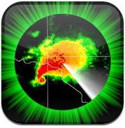
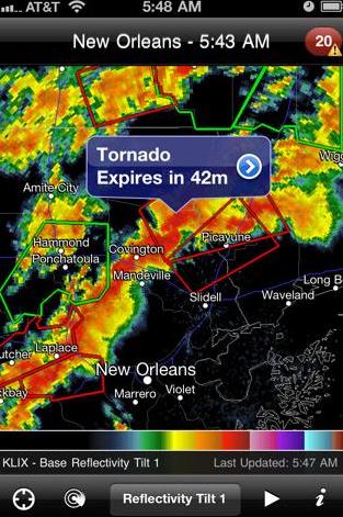
RadarScope.
In my humble opinion this is still the best pure-play radar app. It
works anywhere in the USA (you can get a data signal - which can be
problematic for parts of the western USA away from cell towers). Click
on any NWS Doppler site and see high resolution Doppler radar, an
animated loop, hail detection, velocity fields (to see if a storm is
rotating and capable of generating a tornado), even storm rainfall
estimates - great for determining the risk of flash flooding, which can
be VERY important if you've just pitched a tent next to a babbling
brook, which might be tranformed into a raging, muddy torrent if 6" of
rain falls 20 miles up the road. More details from RadarScope:
"RadarScope
is a specialized display utility for weather enthusiasts and
meteorologists that allows you view NEXRAD Level 3 radar data along with
our most requested new feature, Tornado, Severe Thunderstorm, and
Flash Flood Warnings issued by the National Weather Service. It can
display the latest reflectivity, velocity, and other products from any
NEXRAD radar site in the United States, Guam and Puerto Rico. These
aren't smoothed PNG or GIF images, this is real Level 3 radar data
rendered in its original radial format for a high level of detail.
This version *now includes* support for Hawaii, Alaska, and Guam!
Whether you are scanning reflectivity for a mesocyclone's tell-tale hook echo, trying to pinpoint the landfall of a hurricane's eye wall, or looking for small features like velocity couplets in the storm relative radial velocity product, only RadarScope gives you the power to view true radial NEXRAD weather radar on your iPhone or iPod touch.
When there are any Tornado Warnings (outlined in RED), Severe Thunderstorm Warnings (YELLOW polygons), or Flash Flood Warnings (GREEN polygons) in effect throughout the US, tap the warning button in the top right corner to browse the list of current warnings, view the details, and even zoom to the selected warning on the map".
PYKL3 For Android. Much of the same functionality of RadarScope can be found in the (new) PYKL3 app for Android phones. Functionality includes:
* NEXRAD Level 3
* Local Storm Reports (LSR)
* SPC Day 1 Outlooks
* SPC Thunderstorm and Tornado Watches
* Summarized Lightning
* NWS Storm Tracks
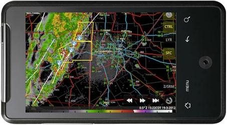
My-Cast.
(no, I don't get a commission). My last company (Digital Cyclone) was
sold to Garmin, and they have what I still consider to be the best
warning app on the planet. I'm a little biased, yes, but I've tested
scores of weather apps and I still think My-Cast Weather Radar, created by Digital Cyclone, is the
best overall app for getting storm warnings. You can even set it up to
give you "lightning alerts" (if lightning strikes within 20 miles of
your location you get an SMS alert, telling you precisely how far away
it was, and what direction the strike was). More details:
"The
award-winning My-Cast app delivers comprehensive yet intuitive weather
information specifically for the iPhone and iPod Touch. Un-cluttered
base maps display animated radar, clouds and StormWatch severe weather
alerts allowing effortless interpretation of how the weather affects
your day. As you check out the current weather, you may see drifting
clouds or falling rain as My-Cast's distinctive weather themes come to
life. Whether you are interested in weather for today, tomorrow or next
week, My-Cast has you covered. When severe weather strikes, My-Cast
transmits the latest alerts direct from the National Weather Service.
• Real-time, animated radar
• Weather Map with conditions, temperatures, dew points, wind direction and wind speed overlays
• Animated Visible and Infrared Clouds
• Interactive StormWatch map with National Weather Service alerts
• Complete severe weather warnings, watches, and advisory alert text
• 7-day forecast with high/low temperatures and chance of precipitation
• Hourly forecast with temps, wind speed/direction and chance of precipitation
• Forecast graph including past, present and forecast wind, dew point, temperature, and sky conditions
• Save your favorite and recently viewed locations for anywhere in the U.S.
• Shake for live data refresh
• One-button push for GPS positioning
• No ads!"
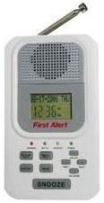
Weather Radio.
This is another app that sends out real-time warnings, only this one
follows the SMS warning with a real-time stream from the local NWS
office, so you can hear the latest warnings in audio form, providing
another welcome level of detail. More details on Weather Radio:
"Listen
to over 170 scanner radio stations providing access to NOAA Weather
Radio All Hazards (NWR) broadcasts. NWR is a nationwide network of radio
stations broadcasting continuous weather information. NWR broadcasts
official Weather Service warnings, watches, forecasts and other hazard
information 24 hours a day, 7 days a week. Weather Radio comes with
Twitter & Facebook support: tell your friends what station you're
listening to, "live", without stopping your audio to invoke an external
Twitter or Facebook client! Weather Radio allows users to select from
NWR audio streams by State-City, or add your favorite stream."
* all 3
apps are available on iTunes. Some of these may be available for Android
and Blackberry as well. It's well worth your time to look into this
and download these onto your phone, set up your favorite locations
(home, work, cabin, beach, etc) and see how they can give you the
information you need to make smarter decisions, and keep your family
out of storm-related trouble.

Severe Alerts – Keep up to date with the latest severe weather for your current location as well as all of your saved favorites.
View – With view feature, you can watch WeatherNation on demand with advanced adaptive bit rate streaming to provide you with the best viewing experience. With WeatherNation’s view feature, you can watch WeatherNation’s 24/7 service LIVE around the clock.
Sync Calendar – With our sync calendar feature, you can automatically and effortlessly look up weather information associated to events on your iPhone’s calendar. It’s a simple way to keep up with the weather wherever you are or may go.
Maps/Radars – WeatherNation provides the latest in storm tracking with our interactive weather maps/radars. You decide the overlays you want to see from radar, satellite, visible satellite, global satellite, advisories, snow depth, current temperatures, current winds, current dewpoint, current humidity, current wind chill, and current heat index. Select specific point data as well like storm cells, storm reports, climate records, or even wildfires. You can also select the type of map you prefer from a standard base map, satellite image base map, or even a hybrid.
From Alerts Broadcaster (issued Monday morning):
* 17+ U.S. tornadoes in the last 24 hours; another outbreak expected later today over central USA.
* Stalled storm increases flood potential Upper Midwest and Mississippi River Valley.
* 3-10" rains predicted for southern China - more flooding likely.
* "Andrea" in the Gulf of Mexico within 2 weeks?
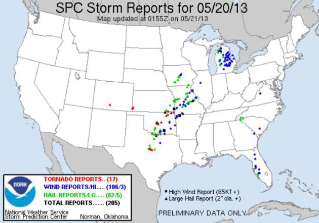
* It's worth pointing out that SPC did have much of Oklahoma in a moderate risk; not the immediate Moore area, but when the moderate risk is that close you know it could be a very busy day with an enhanced risk of large, violent, long-track tornadoes.
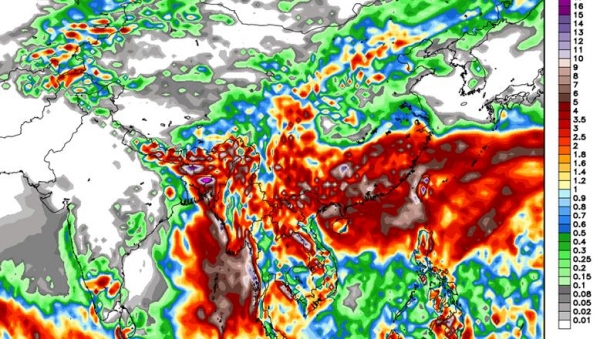
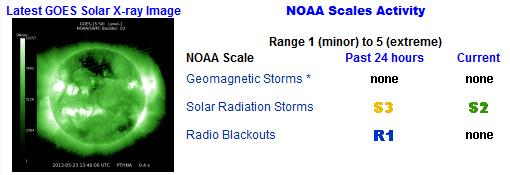
Summary: The latest X-class solar flare (there have been 4 since Mother's Day) produced a CME (Coronal Mass Ejection) capable of minor fluctuations to the grid, mainly over far northern latitudes over the next 24 hours. NASA and NOAA don't appear particularly concerned over this outbreak of Space Weather; we'll continue to monitor conditions, which can change quickly. Another tornado outbreak over the central USA is likely later today; an atmospheric holding pattern squeezing out more flooding T-storms as far north as the Twin Cities, Madison and Fargo. Many streams and rivers will continue to flood across southern China, and we're watching for possible tropical development in the Gulf of Mexico or Caribbean within 2 weeks. If sustained winds top 39 mph we'll have Tropical Storm Andrea. It's still (very) early, and we'll watch the tropics and keep you posted.

TODAY: Lingering showers, rumble of thunder? Winds: SW 8-13. High: near 70
TUESDAY NIGHT: Showers diminish - still damp. Low: 53
WEDNESDAY: More showers, cooler. High: 59
THURSDAY: Partly sunny and pleasant again. Wake-up: 49. High: 68
FRIDAY: Showers and T-storms likely (heaviest southern MN). Wake-up: 51. High: 67
SATURDAY: Wet start, then peeks of PM sun. Wake-up: 52. High: 69
SUNDAY: Partly sunny, cool breeze. Wake-up: 53. High: 68
MEMORIAL DAY: Not bad for a holiday. Mild sun. Wake-up: 50. High: 71
* cumulonimbus image above courtesy of Edward Sklar.
Kya apne Is App ko Avi tak try nhi kia Xperia Transfer Mobile Apk
ReplyDelete