By Paul Douglas
If you're not paranoid you're probably not paying attention. As annoying as spring has been (and it HAS been a pain in the Doppler) at least we're not grappling with life-threatening weather.
I keep an eye on global natural disasters for Fortune 500 companies and sleep with one eye open. Let's see: possible volcanic eruptions near Mexico City & Alaska, SARS epidemics, Cyclone Mahasen pushing toward Bangladesh, and 4 X-class solar flares since Sunday.
NASA's ACE satellite may only be able to give a 1 hour heads-up of a flare capable of bringing down the power grid. The odds are low, but not zero, and the 11-year solar cycle peaks later this year. No wonder you want to turn over to the sports page.
No weather worries today, just lukewarm sun and a gentle breeze. Spring the way it was meant to be. Another sloppy warm front sparks T-storms Friday into Monday. 1-2" rains may fall; even a few severe T-storms over the weekend - the first of the year for most of Minnesota.
No need to water the lawn anytime soon: puddles linger into Tuesday. Good news: it probably won't snow up north (good grief) but don't pack away light jackets just yet.
At least the drought is fading fast.
________________________________________________________________________
Todd's Conservation MN Outlook for the Twin Cities and all of Minnesota
THURSDAY: Mix of clouds & sun, lukewarm. High: 79. Winds: East 5.
THURSDAY NIGHT: Thunderstorms arrive. Low: 59
FRIDAY: Showers and T-storms, some heavy. Locally heavy rain likely. High: 71
SATURDAY: Humid, few strong to severe T-storms up North? Wake-up: 62. High: 83
SUNDAY: More locally heavy rain/thunder possible, cooler. Wake-up: 64. High: 79
MONDAY: Mostly cloudy and cooler with more showers/storms. Wake-up: 63. High: 75
TUESDAY: Risk of light jackets. More clouds and showers. Wake-up: 58. High: 66
WEDNESDAY: Showers taper... Lawns looking quite green! Wake-up: 53. High: 59
______________________________________________________________________
Summery Scenario
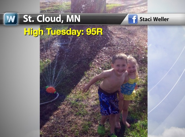
Tuesday's high temps reached record levels in many locations from the Central Plains to the Midwest. Thanks to Staci Weller for the picture below out of St. Cloud, MN where they hit a record high of 95°!!
Fleece Blanket Giveaway?
The Twin Cities hit a record high of 98° on Tuesday, the warmest reading since July 16th, 2012. Interestingly, the Minnesota Twins' giveaway to the first 10,000 fans was a fleece blanket! You can't make this stuff up!! LOL - thanks to Andy Mair for the picture below who had a birthday on Tuesday and caught a home run ball! You can't make that up either!


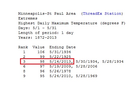
3rd Hottest May Temp for Minneapolis, MN!
According to the National Weather Service, the 98° high temp in the Twin Cities was the 3rd warmest May temperature on record! Note the other records and especially the dates. 1934 had 3 out of the top 5 warmest May temps in the recorded history.
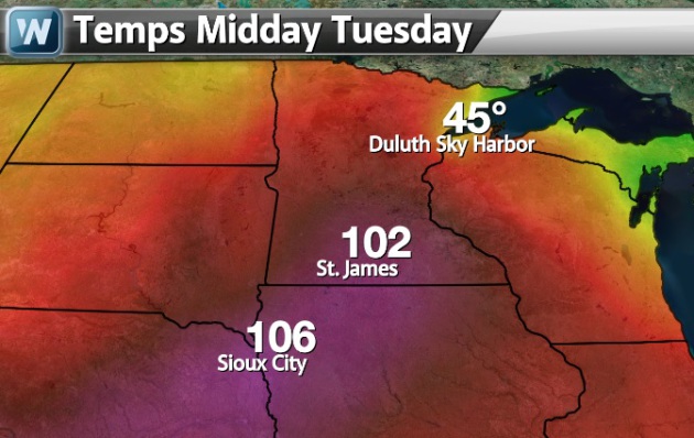
I lived in Duluth, MN for 4 years and I always considered Spring to be the hardest time of the year due to the annoyingly and persistant cold weather near Lake Superior. The map below shows temps on Midday Tuesday across the region. While St. James, MN and Sioux City, IA were in the low 100s, downtown Duluth was nearly 60° cooler at 45°! There's a saying in Duluth; "Cooler by the Lake" and it certainly help true yesterday... it's considered to be the air conditioned city!
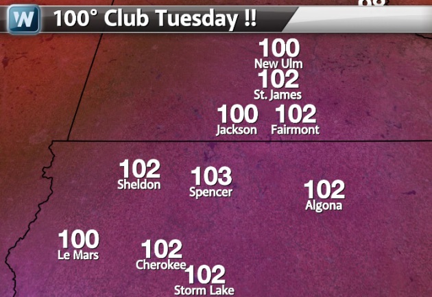
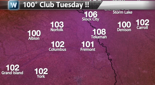
100 Degree Club
Here are a number of cities that I could find that hit 100°+ on Tuesday... I may have missed a few! There were too many to keep track! By the way, that 106° temp in Sioux City, IA was the hottest May temperature ever recorded in that city!
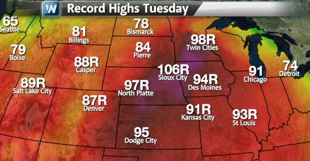
Summer-Like Temperatures...
This is a map more typical of the dog days of Summer... July. There were several record highs from the Intermountain West to the central part of the country. All the numbers that have an 'R' appended to it, was a record for Tuesday. Chicago even made it into the 90s yesterday, but not quite to record levels.
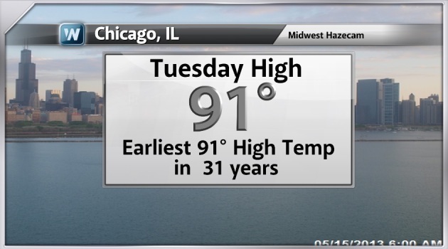
Chicago Hits 90° For The First Time in 2013!
That 91° high temp on Tuesday was the earliest 91° high temp in 31 years! By the way, Chicago didn't reach 90° until May 19th last year. That is pretty surprising considering how warm it was last spring.
Spring Wildfires
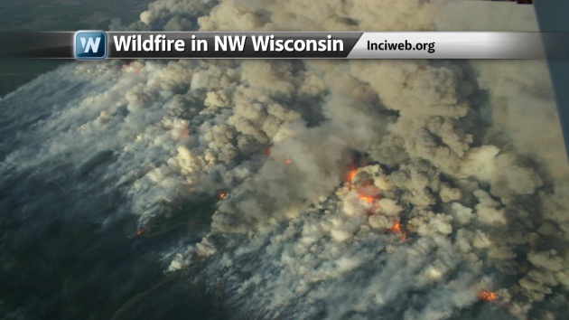
Thanks to my good friend Clint Austin from the Duluth News Tribune for the picture below out of Northwest Wisconsin. The extreme heat and windy conditions made for extreme fire weather conditions on Tuesday. According to www.inciweb.org, as of midday Wednesday, the fire had consumed nearly 8,700 acres and 50 sturctures. The good news is that it was 90% to 95% contained.
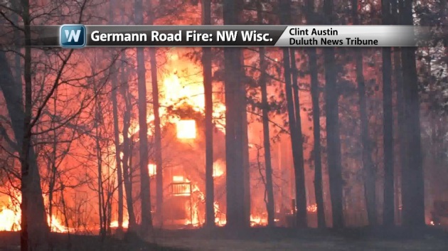
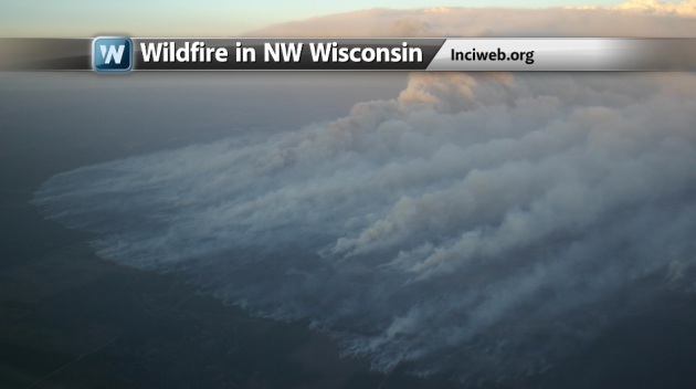
Germann Road Fire in Northwest Wisconsin
Here are more pictures from www.inciweb.org on the Germann Road Fire in Northwest Wisc.
See more HERE:
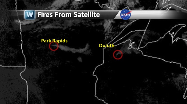
Fires From Space
The image below shows smoke plumes visible from space from Tuesday afternoon. It's also pretty wild to see ice still visible on Lake Mille Lacs.
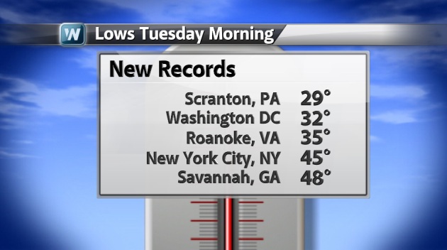
Record Cold in the Northeast
We also had record cold in the Northeast earlier this week too. Take a look at some of the records that were broken on AM Tuesday...
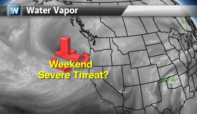
Weekend Severe Threat
Extended model runs are still suggesting a fairly vigorous low in the Pacific, which will translate into a several day thunderstorms threat across the middle part of the country. Keep in mind that some of these storms could be severe! In fact, the Storm Prediction Center has already issued outlooks for the weekend thunder threat.
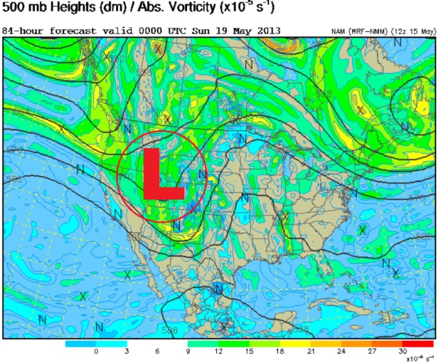
500mb Vorticity (Spin)
This is the 500mb vorticity map for saturday, which shows spin in the atmosphere. There a fairly large trough of low pressure in the west, which will help to envigorate some thunderstorm activity in the middle part of the country by the weekend.
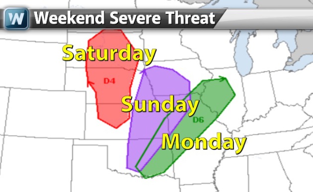
Weekend Severe Threat?
Showers and thunderstorms will become more numerous into the weekend with the threat of some of these storms to become severe. Here's the Storm Prediction Center outlook ahead.
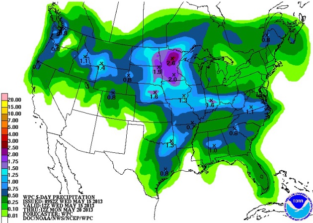
Heavy Rain Ahead
NOAA's HPC 5 day precipitation forecast suggests a decent amount of rain headed into the Midwest by late week/weekend ahead. Some spots could see 1" to 2"+ with strong to severe thunderstorms... Stay tuned for more!
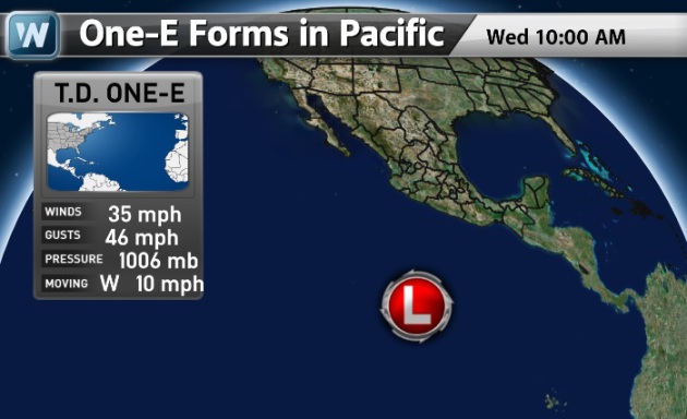
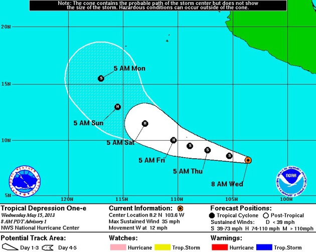
Tropical Season?
On Wednesday, our first tropical depression (One-E) developed in the Pacific Southwest of Mexico! It is expected to become Hurricane Alvin later this week!
Tracking Hurricane Alvin By Friday?
"THE EASTERN NORTH PACIFIC HURRICANE SEASON HAS WASTED NO TIME
GETTING STARTED. THE LOW PRESSURE SYSTEM THAT WE HAVE BEEN
MONITORING SOUTH OF THE MEXICAN COAST BECAME BETTER ORGANIZED
OVERNIGHT...AND A NEARLY UNBROKEN BAND OF DEEP CONVECTION NOW WRAPS
AROUND THE SOUTHERN AND WESTERN SIDE OF THE CIRCULATION. DVORAK
INTENSITY ESTIMATES HAVE INCREASED AND ARE NOW T2.0 FROM TAFB AND
T1.5 FROM SAB...SO THE SYSTEM IS BEING DESIGNATED AS A 30-KT
TROPICAL DEPRESSION.
THE CURRENT MOTION ESTIMATE IS 280 DEGREES AT 10 KT. THE DEPRESSION
IS SITUATED ON THE SOUTHWESTERN PERIPHERY OF A MID-LEVEL RIDGE THAT
EXTENDS FROM THE BAY OF CAMPECHE SOUTHWESTWARD OVER THE PACIFIC
WATERS. EVEN THOUGH A MID-LEVEL TROUGH IS LIKELY TO AMPLIFY IN THE
VICINITY OF CALIFORNIA IN THE COMING DAYS...THE DEPRESSION IS SO
FAR SOUTH THAT ANY EFFECTS ON STEERING SHOULD BE MINIMAL. A
NORTHWESTWARD MOTION IS POSSIBLE IN 4 TO 5 DAYS ONCE THE SYSTEM
REACHES THE WESTERN END OF THE RIDGE. THERE IS SOME DISAGREEMENT
AMONG THE GLOBAL MODELS TOWARD THE END OF THE FORECAST PERIOD...BUT
THE OFFICIAL FORECAST IS CLOSER TO THE SOLUTIONS THAT SHOW A
STRONGER SYSTEM...SPECIFICALLY THE GFS...BAM MEDIUM...AND BAM DEEP.
THE DEPRESSION IS EMBEDDED IN A ZONE OF UPPER-LEVEL DIFFLUENCE TO
THE EAST OF THE SUBTROPICAL JET...AND IT WILL BE TRAVERSING THE
WARMEST WATERS OF THE EASTERN NORTH PACIFIC OVER THE NEXT FEW DAYS.
THIS SHOULD SUPPORT STRENGTHENING FOR AT LEAST THE NEXT 3 TO 4 DAYS
BEFORE THE SYSTEM REACHES STRONG UPPER-LEVEL WESTERLIES AND
APPROACHES COOLER WATERS. SINCE CONDITIONS APPEAR FAVORABLE...IT
SEEMS REASONABLE THAT THE DEPRESSION SHOULD AT LEAST BE ABLE TO
KEEP UP WITH A CLIMATOLOGICAL INTENSIFICATION RATE. THE OFFICIAL
FORECAST THEREFORE SHOWS FASTER STRENGTHENING AND A HIGHER PEAK
INTENSITY THAN SHIPS AND LGEM SINCE THE CLIMATOLOGY-PERSISTENCE
MODEL SHIFOR IS HIGHER THAN EITHER OF THOSE TWO MODELS."
Read more from the National Hurricane Center HERE:
Thanks for checking in, have a great rest of your week!
Don't forget to follow me on Twitter @TNelsonWNTV

No comments:
Post a Comment