By Todd Nelson
I hope you were able to find your thunderwear out of the back of the closet this week. The extended forecast calls for thunderous downpours over the next several days, a recipe that will have your lawn green in no time!
The U.S. Drought Monitor released it's latest outlook on Thursday and it still showed nearly 13% of Minnesota in a severe drought, down from nearly 15% last week. Keep in mind that 3 months ago, nearly 85% of the state was in a severe drought. There's a silver lining to the cool and wet Spring that we've had so far; the drought is slowly easing!
2" to 4" of rain may be possible across parts of Minnesota by the time this storm wrings itself out
sometime next week. There is literally rain/thunder in the forecast everyday until next Wednesday!
I have a hunch that many folks will need a new pair of thunderwear at some point next week as they'll get some pretty good mileage throught the weekend.
I could even see a few strong storms around the state on Saturday.
According to Iowa Mesonet, the MSP County Warning Area has gone approximately 265 days without a tornado warning issued in the area. 2012 saw it's first tornado on March 19th.
_____________________________________________________________
Todd's Conservation MN Outlook for the Twin Cities and all of Minnesota
FRIDAY: Showers and T-storms, some heavy. Locally heavy rain likely. High: 68. Winds: ESE 10-15
SATURDAY: Humid, few strong to severe T-storms up North? High: 81
SUNDAY: More locally heavy rain/thunder possible, cooler. Wake-up: 65. High: 79
MONDAY: Soggy. Scattered showers and storms. Wake-up: 64. High: 76
TUESDAY: More rain, rumbles possible. Wake-up: 58. High: 68
WEDNESDAY: Mostly cloudy with lingering showers. Wake-up: 56. High: 69
THURSDAY: Drier day. Lawns look quite green. Wake-up: 53. High: 69
_______________________________________________________________
Deadly Texas Twisters
Wednesday evening was pretty scary for some folks in northern Texas as tornadoes developed just west of the Dallas/Ft. Worth area. The most significant tornado touched down near Granbury, TX just after 8pm where at least 6 people died and more than 100 were injured. Thanks to DrTornadoCooley for the picture below out of Millsap, TX.
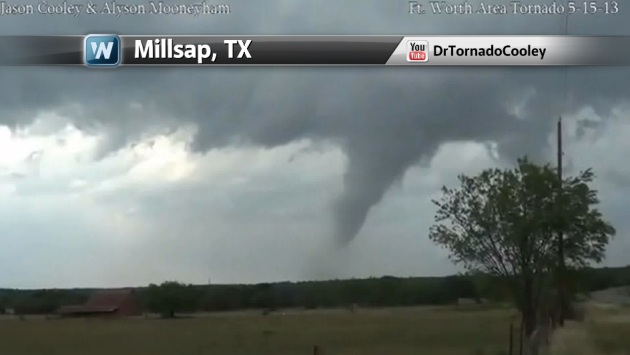
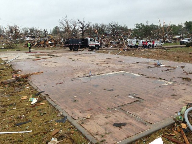
Granbury, TX Tornado
According to the National
Weather Service out of Ft. Worth, TX the Granbury, TX tornado was
considered to be an EF4 tornado. Look how it whipped this house right
off of it's foundation!
16 Tornadoes Confirmed!
PUBLIC INFORMATION STATEMENT
NATIONAL WEATHER SERVICE FORT WORTH TX
844 PM CDT THU MAY 16 2013...NWS DAMAGE SURVEYS FOR 05/15/2013 TORNADO EVENT...
...16 TORNADOES HAVE NOW BEEN CONFIRMED. ALL SURVEY CREWS HAVE
RETURNED FOR THE DAY AND SOME OF THEIR INFORMATION HAS BEEN
INCLUDED IN THIS UPDATE...
SO FAR 16 TORNADOES HAVE BEEN CONFIRMED. THE FIRST TORNADO
OCCURRED IN MONTAGUE COUNTY AT 538 PM CDT. THE LAST REPORTED
TORNADO WAS AROUND 1210 AM IN ENNIS.
THIS INFORMATION IS CONSIDERED PRELIMINARY. SURVEY TEAMS WERE
SENT TO JOHNSON COUNTY...HOOD COUNTY...PARKER COUNTY...ELLIS
COUNTY AND MONTAGUE COUNTY. OVER THE NEXT FEW DAYS WE WILL
CONTINUE TO COLLECT DATA...TALK WITH EMERGENCY OFFICIALS AND
RESPONDERS...AND EYE WITNESSES...REVIEW RADAR DATA...PICTURES AND
VIDEOS. THE INFORMATION CONTAINED IN THIS REPORT IS SUBJECT TO AND
LIKELY WILL CHANGE.
AN ADDITIONAL SURVEY TEAM WILL BE SENT TO SURVEY DAMAGE NORTHWEST
OF CRESSON IN SOUTHERN PARKER COUNTY ON FRIDAY.
.TORNADO #1 - BELCHERVILLE/MONTAGUE COUNTY...
THIS TORNADO WAS REPORTED ONE MILE WEST OF BELCHERVILLE BY STORM
SPOTTERS. NO ADDITIONAL DETAILS ON THIS TORNADO ARE AVAILABLE AT
THIS TIME. ADDITIONAL INFORMATION WILL BE PROVIDED ON THIS TORNADO
LATER.
.TORNADO #2 - LAKE AMON G. CARTER/MONTAGUE COUNTY...
RATING: EF-1
ESTIMATED PEAK WIND: 100 MPH
INJURIES: 1
SURVEY CREWS FOUND FIVE HOMES DAMAGED BY THIS TORNADO SOUTH OF LAKE
AMON G. CARTER. FOUR OF THE HOMES WERE SIGNIFICANTLY DAMAGED AND ONE
HOME WAS DESTROYED. IN ADDITION...SIGNIFICANT TREE DAMAGE WAS
REPORTED. ONE MINOR INJURY WAS REPORTED. ADDITIONAL INFORMATION WILL
BE PROVIDED ON THIS TORNADO LATER.
.TORNADO #3 - ALVORD/WISE COUNTY...
THIS TORNADO WAS REPORTED BY THE PUBLIC AND STORM SPOTTERS. NO
ADDITIONAL DETAILS ON THIS TORNADO ARE AVAILABLE AT THIS TIME.
ADDITIONAL INFORMATION WILL BE PROVIDED ON THIS TORNADO LATER.
.TORNADO #4 - MILLSAP/PARKER COUNTY...
RATING: EF-1
ESTIMATED PEAK WIND: 100 MPH
SURVEY CREWS FOUND FIVE HOMES SIGNIFICANTLY DAMAGED BY THIS TORNADO.
IN ADDITION...SIGNIFICANT TREE DAMAGE WAS OBSERVED. ADDITIONAL
INFORMATION WILL BE PROVIDED ON THIS TORNADO LATER.
.TORNADO #5 - GRANBURY/HOOD COUNTY...
RATING: EF-4
PATH LENGTH /STATUTE/: 2.75 MILES
PATH WIDTH /MAXIMUM/: 880 YARDS/0.5 MILES
FATALITIES: 6
INJURIES: DOZENS
SIGNIFICANT DAMAGE OCCURRED WITH THIS TORNADO INCLUDING HOMES WIPED
CLEAR OFF THE FOUNDATION. TWO HOMES SUFFERED EF-4 MAGNITUDE DAMAGE
AND SEVERAL MORE SUFFERED EF-3 MAGNITUDE DAMAGE. ADDITIONAL
INFORMATION ON THIS TORNADO WILL BE PROVIDED LATER.
.TORNADO #6 - PECAN PLANTATION/HOOD COUNTY...
RATING: EF-1
ESTIMATED PEAK WIND: 90-100 MPH
SURVEY CREWS FOUND AN ADDITIONAL DAMAGE PATH SEPARATE FROM TORNADO
#5 THAT AFFECTED GRANBURY. ADDITIONAL INFORMATION ON THIS TORNADO
WILL BE PROVIDED LATER.
.TORNADO #7 - WEST OF ANNETTA SOUTH/PARKER COUNTY...
SIGNIFICANT DAMAGE WAS REPORTED ALONG TIN TOP ROAD BY EMERGENCY
OFFICIALS. A SURVEY CREW WILL BE SENT TO THE DAMAGED AREA ON
FRIDAY. ADDITIONAL INFORMATION ON THIS TORNADO WILL BE PROVIDED
LATER.
.TORNADO #8 - CLEBURNE/JOHNSON COUNTY...
RATING: EF-3
ESTIMATED PEAK WIND: 140 MPH
PATH LENGTH /STATUTE/: 8.5 MILES
PATH WIDTH /MAXIMUM/: 1060 YARDS/0.6 MILES
SIGNIFICANT DAMAGE OCCURRED WITH THIS STRONG TORNADO. DOZENS OF
HOMES WERE DAMAGED AND AT LEAST 3 OR 4 HOMES SUFFERED EF-3
MAGNITUDE DAMAGE. ADDITIONAL INFORMATION WILL BE PROVIDED ON THIS
TORNADO LATER.
.TORNADO #9 - 6 ESE CLEBURNE/JOHNSON COUNTY...
RATING: EF-0
ESTIMATED PEAK WIND: 85 MPH
SURVEY CREWS FOUND AN ADDITIONAL DAMAGE PATH SEPARATE FROM TORNADO
#8. DAMAGE WITH THIS TORNADO WAS MOSTLY TO TREES BUT 5
MANUFACTURED HOMES ALSO SUFFERED ROOF DAMAGE. ADDITIONAL
INFORMATION WILL BE PROVIDED ON THIS TORNADO LATER.
.TORNADO #10 - MILLS COUNTY...
THIS BRIEF TORNADO WAS REPORTED BY STORM SPOTTERS. NO ADDITIONAL
DETAILS ON THIS TORNADO ARE AVAILABLE AT THIS TIME. ADDITIONAL
INFORMATION WILL BE PROVIDED ON THIS TORNADO LATER.
.TORNADOES #11 AND #12- NORTH OF EVANT/HAMILTON COUNTY...
VIDEO FOOTAGE SHOWED 2 BRIEF TORNADOES OCCURRED SIMULTANEOUSLY
APPROXIMATELY 2 MILES NORTH OF EVANT. NO ADDITIONAL DETAILS ON
THESE TORNADOES ARE AVAILABLE AT THIS TIME. ADDITIONAL INFORMATION
WILL BE PROVIDED LATER.
.TORNADO #13 - ENNIS/ELLIS COUNTY...
RATING: EF-1
ESTIMATED PEAK WIND: 90 MPH
PATH LENGTH /STATUE/: APPROXIMATELY 6 MILES
SIGNIFICANT DAMAGE OCCURRED IN ENNIS WITH THIS TORNADO. THE TORNADO
BEGAN NEAR CLAY STREET AND ENNIS AVENUE. THE TORNADO TRAVELED EAST
FROM THERE AND CROSSED INTERSTATE 45 SOUTH OF ENNIS AVENUE.
ACCORDING TO PRELIMINARY INFORMATION FROM LOCAL OFFICIALS...17
HOMES WERE DAMAGED WITH 4 HOMES LEFT INHABITABLE. A TOTAL OF 55
COMMERCIAL PROPERTIES WERE DAMAGED WITH 20 OF THOSE PROPERTIES
SUFFERING SEVERE DAMAGE. ADDITIONAL INFORMATION WILL BE PROVIDED
ON THIS TORNADO LATER.
.TORNADO #14 - SE OF MINERAL WELLS/PALO PINTO COUNTY...
RATING: EF-0
START DATE: 05/15/2013
START TIME: 6:41 PM CDT
START LOCATION: APPROXIMATELY 3.5 MILES SOUTH-SOUTHEAST OF MINERAL WELLS
END DATE: 05/15/2013
END TIME: 6:42 PM CDT
END LOCATION: APPROXIMATELY 3.5 MILES SOUTH-SOUTHEAST OF MINERAL WELLS
OFF DUTY NWS METEOROLOGISTS PHOTOGRAPHED A TORNADO APPROXIMATELY
3.5 MILES SOUTH-SOUTHEAST OF MINERAL WELLS OR 4 MILES NORTHWEST OF
MILLSAP. THIS TORNADO IS SEPARATE FROM THE MILLSAP TORNADO. SO FAR
NO DAMAGE HAS BEEN REPORTED FROM THIS BRIEF TORNADO.
.TORNADO #15 - E OF MILLSAP/PARKER COUNTY...
RATING: EF-0
START DATE: 05/15/2013
START TIME: 7:22 PM CDT
START LOCATION: APPROXIMATELY 3 MILES EAST OF MILLSAP
END DATE: 05/15/2013
END TIME: 7:25 PM CDT
END LOCATION: APPROXIMATELY 3 MILES EAST OF MILLSAP
OFF DUTY NWS METEOROLOGISTS PHOTOGRAPHED A TORNADO APPROXIMATELY
3 MILES EAST OF MILLSAP. THIS TORNADO IS SEPARATE FROM THE MILLSAP
TORNADO. SO FAR NO DAMAGE HAS BEEN REPORTED FROM THIS TORNADO.
.TORNADO #16 - NOCONA LAKE/MONTAGUE COUNTY...
THIS TORNADO WAS REPORTED NEAR NOCONA LAKE BY STORM SPOTTERS.
PICTURES OF THIS TORNADO WERE ALSO OBTAINED. SOME DAMAGE HAS BEEN
REPORTED WITH THIS TORNADO BUT NO ADDITIONAL DETAILS ARE AVAILABLE
AT THIS TIME. ADDITIONAL INFORMATION ON THIS TORNADO WILL BE
PROVIDED LATER.
EF SCALE: THE ENHANCED FUJITA SCALE CLASSIFIES TORNADOES INTO THE
FOLLOWING CATEGORIES.
EF0...WEAK......65 TO 85 MPH
EF1...WEAK......86 TO 110 MPH
EF2...STRONG....111 TO 135 MPH
EF3...STRONG....136 TO 165 MPH
EF4...VIOLENT...166 TO 200 MPH
EF5...VIOLENT...>200 MPH
NOTE:
THE INFORMATION IN THIS STATEMENT IS PRELIMINARY AND SUBJECT TO
CHANGE PENDING FINAL REVIEW OF THE EVENT AND PUBLICATION IN
NWS STORM DATA.
$$
JLDUNN
MASSIVE Hail
The National Weather Service out of Ft. Worth, TX confirmed 16 tornadoes as of PM Thursday. Here's a list of the tornadoes and their rating:
NATIONAL WEATHER SERVICE FORT WORTH TX
844 PM CDT THU MAY 16 2013...NWS DAMAGE SURVEYS FOR 05/15/2013 TORNADO EVENT...
...16 TORNADOES HAVE NOW BEEN CONFIRMED. ALL SURVEY CREWS HAVE
RETURNED FOR THE DAY AND SOME OF THEIR INFORMATION HAS BEEN
INCLUDED IN THIS UPDATE...
SO FAR 16 TORNADOES HAVE BEEN CONFIRMED. THE FIRST TORNADO
OCCURRED IN MONTAGUE COUNTY AT 538 PM CDT. THE LAST REPORTED
TORNADO WAS AROUND 1210 AM IN ENNIS.
THIS INFORMATION IS CONSIDERED PRELIMINARY. SURVEY TEAMS WERE
SENT TO JOHNSON COUNTY...HOOD COUNTY...PARKER COUNTY...ELLIS
COUNTY AND MONTAGUE COUNTY. OVER THE NEXT FEW DAYS WE WILL
CONTINUE TO COLLECT DATA...TALK WITH EMERGENCY OFFICIALS AND
RESPONDERS...AND EYE WITNESSES...REVIEW RADAR DATA...PICTURES AND
VIDEOS. THE INFORMATION CONTAINED IN THIS REPORT IS SUBJECT TO AND
LIKELY WILL CHANGE.
AN ADDITIONAL SURVEY TEAM WILL BE SENT TO SURVEY DAMAGE NORTHWEST
OF CRESSON IN SOUTHERN PARKER COUNTY ON FRIDAY.
.TORNADO #1 - BELCHERVILLE/MONTAGUE COUNTY...
THIS TORNADO WAS REPORTED ONE MILE WEST OF BELCHERVILLE BY STORM
SPOTTERS. NO ADDITIONAL DETAILS ON THIS TORNADO ARE AVAILABLE AT
THIS TIME. ADDITIONAL INFORMATION WILL BE PROVIDED ON THIS TORNADO
LATER.
.TORNADO #2 - LAKE AMON G. CARTER/MONTAGUE COUNTY...
RATING: EF-1
ESTIMATED PEAK WIND: 100 MPH
INJURIES: 1
SURVEY CREWS FOUND FIVE HOMES DAMAGED BY THIS TORNADO SOUTH OF LAKE
AMON G. CARTER. FOUR OF THE HOMES WERE SIGNIFICANTLY DAMAGED AND ONE
HOME WAS DESTROYED. IN ADDITION...SIGNIFICANT TREE DAMAGE WAS
REPORTED. ONE MINOR INJURY WAS REPORTED. ADDITIONAL INFORMATION WILL
BE PROVIDED ON THIS TORNADO LATER.
.TORNADO #3 - ALVORD/WISE COUNTY...
THIS TORNADO WAS REPORTED BY THE PUBLIC AND STORM SPOTTERS. NO
ADDITIONAL DETAILS ON THIS TORNADO ARE AVAILABLE AT THIS TIME.
ADDITIONAL INFORMATION WILL BE PROVIDED ON THIS TORNADO LATER.
.TORNADO #4 - MILLSAP/PARKER COUNTY...
RATING: EF-1
ESTIMATED PEAK WIND: 100 MPH
SURVEY CREWS FOUND FIVE HOMES SIGNIFICANTLY DAMAGED BY THIS TORNADO.
IN ADDITION...SIGNIFICANT TREE DAMAGE WAS OBSERVED. ADDITIONAL
INFORMATION WILL BE PROVIDED ON THIS TORNADO LATER.
.TORNADO #5 - GRANBURY/HOOD COUNTY...
RATING: EF-4
PATH LENGTH /STATUTE/: 2.75 MILES
PATH WIDTH /MAXIMUM/: 880 YARDS/0.5 MILES
FATALITIES: 6
INJURIES: DOZENS
SIGNIFICANT DAMAGE OCCURRED WITH THIS TORNADO INCLUDING HOMES WIPED
CLEAR OFF THE FOUNDATION. TWO HOMES SUFFERED EF-4 MAGNITUDE DAMAGE
AND SEVERAL MORE SUFFERED EF-3 MAGNITUDE DAMAGE. ADDITIONAL
INFORMATION ON THIS TORNADO WILL BE PROVIDED LATER.
.TORNADO #6 - PECAN PLANTATION/HOOD COUNTY...
RATING: EF-1
ESTIMATED PEAK WIND: 90-100 MPH
SURVEY CREWS FOUND AN ADDITIONAL DAMAGE PATH SEPARATE FROM TORNADO
#5 THAT AFFECTED GRANBURY. ADDITIONAL INFORMATION ON THIS TORNADO
WILL BE PROVIDED LATER.
.TORNADO #7 - WEST OF ANNETTA SOUTH/PARKER COUNTY...
SIGNIFICANT DAMAGE WAS REPORTED ALONG TIN TOP ROAD BY EMERGENCY
OFFICIALS. A SURVEY CREW WILL BE SENT TO THE DAMAGED AREA ON
FRIDAY. ADDITIONAL INFORMATION ON THIS TORNADO WILL BE PROVIDED
LATER.
.TORNADO #8 - CLEBURNE/JOHNSON COUNTY...
RATING: EF-3
ESTIMATED PEAK WIND: 140 MPH
PATH LENGTH /STATUTE/: 8.5 MILES
PATH WIDTH /MAXIMUM/: 1060 YARDS/0.6 MILES
SIGNIFICANT DAMAGE OCCURRED WITH THIS STRONG TORNADO. DOZENS OF
HOMES WERE DAMAGED AND AT LEAST 3 OR 4 HOMES SUFFERED EF-3
MAGNITUDE DAMAGE. ADDITIONAL INFORMATION WILL BE PROVIDED ON THIS
TORNADO LATER.
.TORNADO #9 - 6 ESE CLEBURNE/JOHNSON COUNTY...
RATING: EF-0
ESTIMATED PEAK WIND: 85 MPH
SURVEY CREWS FOUND AN ADDITIONAL DAMAGE PATH SEPARATE FROM TORNADO
#8. DAMAGE WITH THIS TORNADO WAS MOSTLY TO TREES BUT 5
MANUFACTURED HOMES ALSO SUFFERED ROOF DAMAGE. ADDITIONAL
INFORMATION WILL BE PROVIDED ON THIS TORNADO LATER.
.TORNADO #10 - MILLS COUNTY...
THIS BRIEF TORNADO WAS REPORTED BY STORM SPOTTERS. NO ADDITIONAL
DETAILS ON THIS TORNADO ARE AVAILABLE AT THIS TIME. ADDITIONAL
INFORMATION WILL BE PROVIDED ON THIS TORNADO LATER.
.TORNADOES #11 AND #12- NORTH OF EVANT/HAMILTON COUNTY...
VIDEO FOOTAGE SHOWED 2 BRIEF TORNADOES OCCURRED SIMULTANEOUSLY
APPROXIMATELY 2 MILES NORTH OF EVANT. NO ADDITIONAL DETAILS ON
THESE TORNADOES ARE AVAILABLE AT THIS TIME. ADDITIONAL INFORMATION
WILL BE PROVIDED LATER.
.TORNADO #13 - ENNIS/ELLIS COUNTY...
RATING: EF-1
ESTIMATED PEAK WIND: 90 MPH
PATH LENGTH /STATUE/: APPROXIMATELY 6 MILES
SIGNIFICANT DAMAGE OCCURRED IN ENNIS WITH THIS TORNADO. THE TORNADO
BEGAN NEAR CLAY STREET AND ENNIS AVENUE. THE TORNADO TRAVELED EAST
FROM THERE AND CROSSED INTERSTATE 45 SOUTH OF ENNIS AVENUE.
ACCORDING TO PRELIMINARY INFORMATION FROM LOCAL OFFICIALS...17
HOMES WERE DAMAGED WITH 4 HOMES LEFT INHABITABLE. A TOTAL OF 55
COMMERCIAL PROPERTIES WERE DAMAGED WITH 20 OF THOSE PROPERTIES
SUFFERING SEVERE DAMAGE. ADDITIONAL INFORMATION WILL BE PROVIDED
ON THIS TORNADO LATER.
.TORNADO #14 - SE OF MINERAL WELLS/PALO PINTO COUNTY...
RATING: EF-0
START DATE: 05/15/2013
START TIME: 6:41 PM CDT
START LOCATION: APPROXIMATELY 3.5 MILES SOUTH-SOUTHEAST OF MINERAL WELLS
END DATE: 05/15/2013
END TIME: 6:42 PM CDT
END LOCATION: APPROXIMATELY 3.5 MILES SOUTH-SOUTHEAST OF MINERAL WELLS
OFF DUTY NWS METEOROLOGISTS PHOTOGRAPHED A TORNADO APPROXIMATELY
3.5 MILES SOUTH-SOUTHEAST OF MINERAL WELLS OR 4 MILES NORTHWEST OF
MILLSAP. THIS TORNADO IS SEPARATE FROM THE MILLSAP TORNADO. SO FAR
NO DAMAGE HAS BEEN REPORTED FROM THIS BRIEF TORNADO.
.TORNADO #15 - E OF MILLSAP/PARKER COUNTY...
RATING: EF-0
START DATE: 05/15/2013
START TIME: 7:22 PM CDT
START LOCATION: APPROXIMATELY 3 MILES EAST OF MILLSAP
END DATE: 05/15/2013
END TIME: 7:25 PM CDT
END LOCATION: APPROXIMATELY 3 MILES EAST OF MILLSAP
OFF DUTY NWS METEOROLOGISTS PHOTOGRAPHED A TORNADO APPROXIMATELY
3 MILES EAST OF MILLSAP. THIS TORNADO IS SEPARATE FROM THE MILLSAP
TORNADO. SO FAR NO DAMAGE HAS BEEN REPORTED FROM THIS TORNADO.
.TORNADO #16 - NOCONA LAKE/MONTAGUE COUNTY...
THIS TORNADO WAS REPORTED NEAR NOCONA LAKE BY STORM SPOTTERS.
PICTURES OF THIS TORNADO WERE ALSO OBTAINED. SOME DAMAGE HAS BEEN
REPORTED WITH THIS TORNADO BUT NO ADDITIONAL DETAILS ARE AVAILABLE
AT THIS TIME. ADDITIONAL INFORMATION ON THIS TORNADO WILL BE
PROVIDED LATER.
EF SCALE: THE ENHANCED FUJITA SCALE CLASSIFIES TORNADOES INTO THE
FOLLOWING CATEGORIES.
EF0...WEAK......65 TO 85 MPH
EF1...WEAK......86 TO 110 MPH
EF2...STRONG....111 TO 135 MPH
EF3...STRONG....136 TO 165 MPH
EF4...VIOLENT...166 TO 200 MPH
EF5...VIOLENT...>200 MPH
NOTE:
THE INFORMATION IN THIS STATEMENT IS PRELIMINARY AND SUBJECT TO
CHANGE PENDING FINAL REVIEW OF THE EVENT AND PUBLICATION IN
NWS STORM DATA.
$$
JLDUNN
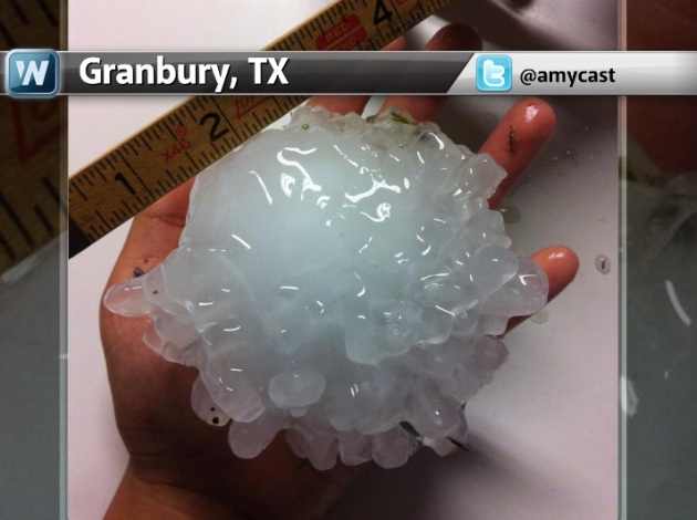
MASSIVE Hail
Take a look at that hailstone
from Granbury, TX. Often hail is a precursor to tornadoes as hail is
typically found closer to the updraft of thunderstorms, just like
tornadoes. The image below from @amycast shows a 4" diameter hailstone!
YIKES!!
Texas Supercells
This is what the radar looked like Wednesday evening as tornadic storms were rolling through Millsap and Granbury, TX.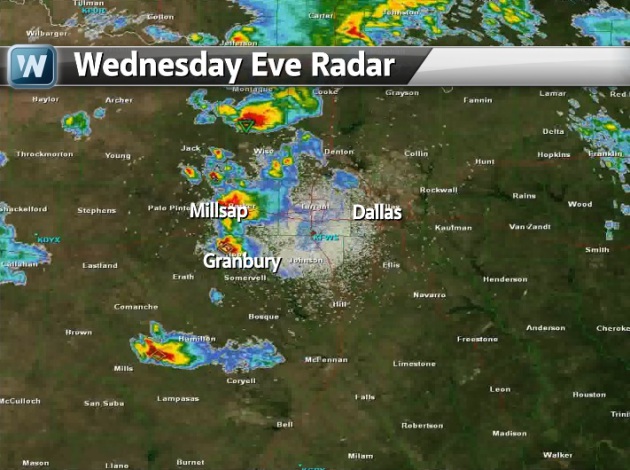
2013 Tornado Drought Continues
According to the Storm Prediction Center (without taking into account Wednesday's tornadoes) there had been 251 PRELIMINARY tornadoes so far this year thru the 15th of May. Interestingly, that quite a bit below the average through today's date!
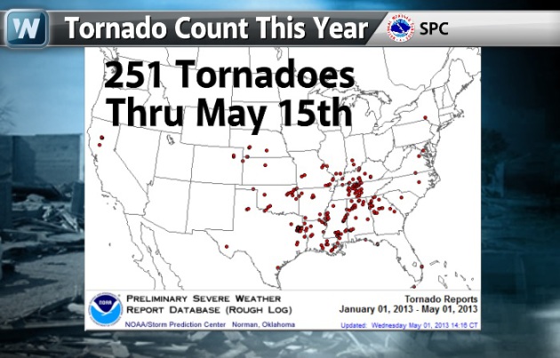
2013 Compared to Average
Here are the numbers for 2013 vs. average through today's date and note how much below average we are!

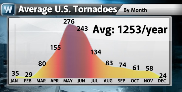
Average U.S. Tornadoes By Month
I thought this was
interesting... the month of May typically sees 276 tornadoes nationwide
and is the most active month out of the year. The cooler weather in the
eastern half of the country can be to blame!
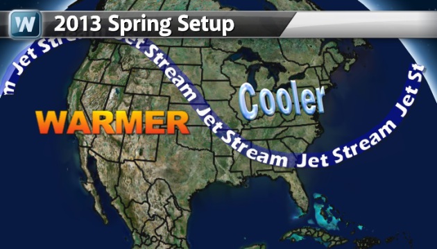
Spring 2013 So Far...
This is what the weather setup
has been like so far this spring. The nearly persistent trough in the
east hasn't allowed much heat and humidity to lift into Tornado Alley,
which is typically where we see most of our tornadoes at this time of
the year.
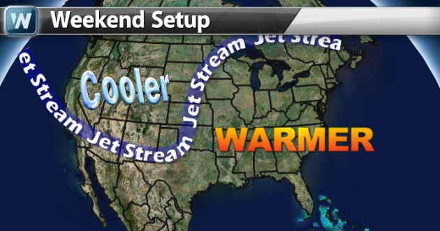
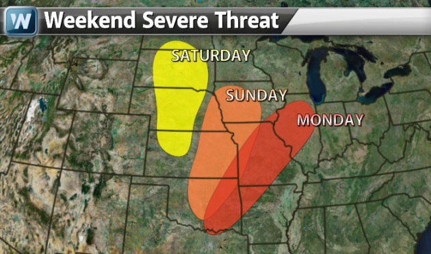
Weekend Weather Setup
A developing Pacific storm will
have severe weather chances returning to the Plains over a several day
period this weekend. Take a look how the upper level winds are changing.
Because of the trough of low pressure in the west, additional heat and
humidity will be able to lift to the north. The incoming storm will help
to envigorate storms over a several day period.
Vigorous Storm
Here's a peek at the storm via water vapor as it was moving into the West on Thursday.
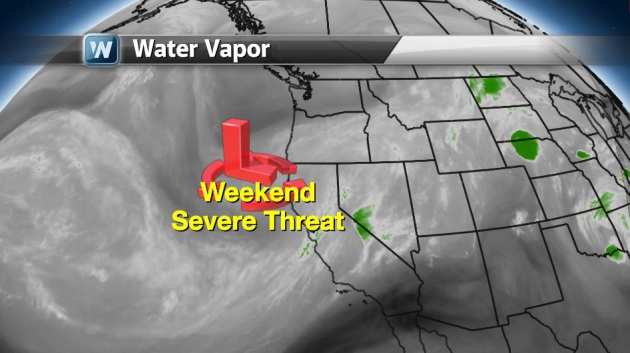
Severe Weather Threat
The Storm Prediction Center has
already highlighted some areas in the middle part of the country for the
possibility of strong to severe weather over the weekend. Stay up to
date with your local weather conditions if you live in these areas.
Heavy Rainfall
There is also a risk for heavy rainfall. NOAA's HPC 5 day precipitation forecast suggests nearly 2" to 4" of rain possible in thundery downpours across the Red River Valley through early next week.

Thanks for checking in, have a great weekend ahead!
Don't forget to follow me on Twitter @TNelsonWNTV

No comments:
Post a Comment