By Todd Nelson
Thanks to a particular 'Common' voice on midday radio for the shout out Friday. He and others that may have cancelled tee times Friday due to the doom and gloom forecast, may have felt a little let down when their backyard rain gauges weren't overflowing. 1" to 2" of heavy rain fell 50 miles south of the Twin Cities by AM Friday leaving most across the Metro cool, damp and breezy.
Rain and thunder remains in the forecast over the next several days, but Saturday may turn out to be the drier day as a warm front lifts into northern Minnesota. A warmer and stickier air mass settles in to the southern half of the state today with spotty showers and storms generally across far northern Minnesota and the Dakotas.
The Storm Prediction Center has highlighted stronger storm potential in neighboring states later today and again tomorrow; we'll get the leftovers of whatever develops south and west of us. Sunday looks like the soggier day of the weekend for us with soaking rains still possible through early next week.
Smells of SPF may return later next week as the sun finally pops out and temps warm. An unsettled weather pattern may return next wknd.
_________________________________________________________
Todd's Conservation MN Outlook for the Twin Cities and all of Minnesota
SATURDAY: AM showers/storms lift into northern MN thru the day. Warmer/stickier afternoon. High: 81
SATURDAY NIGHT: Strong to severe storms across eastern South Dakota/Western MN. Thunder and heavy rain potential increases for the eastern Minnesota. Low: 67
SUNDAY: More locally heavy rain/thunder possible. Some PM storms could be strong to severe across southern Minnesota. High: 82
MONDAY: Still gray. Spotty thundershowers. Wake-up: 64. High: 76
TUESDAY: Cooler. Lingering light rain showers. Wake-up: 54. High: 66
WEDNESDAY: Sprinkles. Peeks of afternoon sunshine? Wake-up: 49. High: 64
THURSDAY: Finally drying out. More sun. Wake-up: 48. High: 68.
FRIDAY: Smells of SPF return. Warmer with more sun. Wake-up: 53. High: 72.
________________________________________________________
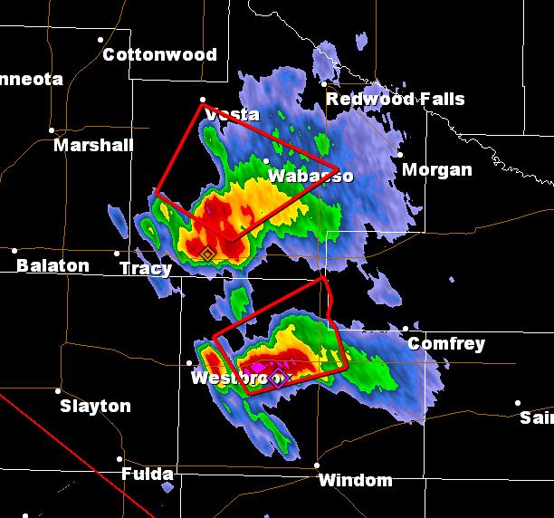
Minnesota Tornadoes on Friday?
Two storms developed late Friday afternoon/evening across southwestern Minnesota with large hail and even tornado reports near Wilder and Lakefield in Jackson county.

This is what the cells looked like on Friday just prior to the southern cell turning tornadic. There were also reports of 2" diameter hail near Lakefield and Windom.
Lovely Weather for a Duck
Thanks to Julie Hickstein for the picture below out of the Twin Cities from Friday. The soggy Friday weather was enough to make even this duck a little weird. Can you spot it?

Stormy Weather Ahead?
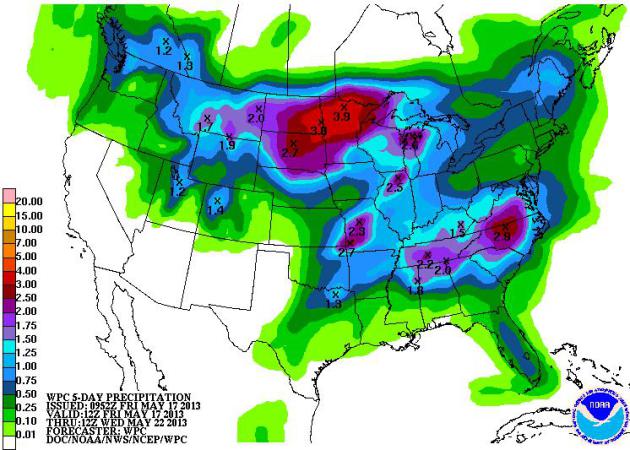
Billie Holiday once sang: "Don't know why there's no sun up in the sky. Stormy Weather." Of course she kept singing and it turned out that it had been raining since her man and her weren't together anymore... I've had this song stuck in my head over the last several days while looking at weather maps. Take a look at NOAA's HPC 5 day precipitation forecat below. A slow moving/waterlogged Pacific storm will wind up over the middle part of the country through next week and keep shower and thunder activity in place over some of the same areas over the next several days. Some may end up with 2" to 4"+ by the time this storm wrings itself out next week.
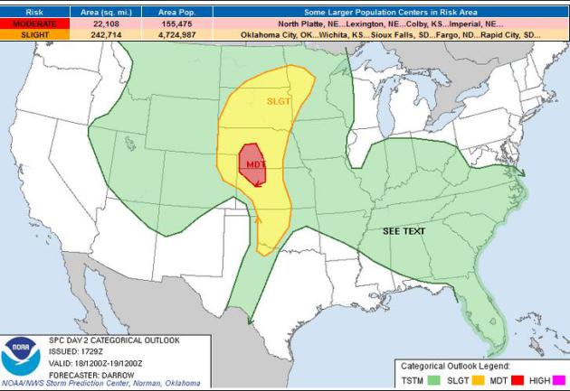
Severe Thunderstorm Threat
This vigorous low pressure
system will help to envigorate strong to severe storms this weekend
across parts of the Midwest. Hail, high winds and isolated tornadoes
can't be ruled out. Stay tuned to local forecasts if you live in
highlighted and surrounding areas this weekend. Keep in mind that
highlighted risk areas will likely change through the weekend as more
information becomes available...
Saturday's Threat:
...PLAINS...
LATEST MODEL GUIDANCE IS IN GENERAL AGREEMENT REGARDING THE
EVOLUTION OF UPPER TROUGH AS IT PROGRESSES ACROSS THE WRN U.S. INTO
THE HIGH PLAINS LATE IN THE PERIOD. OF PARTICULAR CONCERN IS THE
EXPECTED INCREASE IN MID LEVEL FLOW INTO THE HIGH PLAINS ATOP AN
INCREASINGLY MOIST/BUOYANT AIRMASS. LATEST SATELLITE IMAGERY
DEPICTS EXTENSIVE LOW CLOUDS ACROSS OK WITH A DECIDEDLY ELY LOW
LEVEL COMPONENT WITHIN THE BOUNDARY LAYER. THIS CLOUDINESS WILL BE
STUBBORN TO ERODE DURING THE DAY1 PERIOD AND IN THE ABSENCE OF
MEANINGFUL THUNDERSTORM ACTIVITY ACROSS THE SRN/CNTRL PLAINS THROUGH
SATURDAY MORNING ABUNDANT LOW LEVEL MOISTURE SHOULD RAPIDLY RETURN
ACROSS KS INTO NEB SATURDAY.
LATEST THINKING IS WARM ADVECTION MAY DRIVE A BOUT OF EARLY MORNING
CONVECTION ACROSS PARTS OF THE ERN DAKOTAS BENEATH MODEST LLJ.
WHILE THIS ACTIVITY MAY PRODUCE SOME HAIL...IT SHOULD SPREAD EWD
INTO THE UPPER MS VALLEY DURING THE MID DAY HOURS AS A WEAK BRANCH
OF THE LLJ FOCUSES INTO THIS REGION.
LATEST SHORT RANGE MODEL GUIDANCE INSISTS STRONG HEATING WILL OCCUR
ACROSS SERN CO INTO NWRN TX. THIS SHOULD ALLOW DRYLINE TO MIX TO A
POSITION NEAR THE OK BORDER...ARCING NWWD TO A SFC LOW OVER WRN KS
BY 19/00Z. WITH SFC DEW POINTS EXPECTED TO RISE WELL INTO THE
MID-UPPER 60S EAST OF THE DRYLINE...EXTREME INSTABILITY MAY DEVELOP
ALONG A CORRIDOR FROM WRN OK INTO NWRN KS WHERE SBCAPE COULD EXCEED
4000 J/KG. AS TEMPERATURES WARM INTO THE LOWER 90S ACROSS THE TX
PANHANDLE INTO SWRN KS INHIBITION WILL BE NEGATED AND DISCRETE
SUPERCELL STRUCTURES ARE EXPECTED TO DEVELOP. HAVE INCREASED THE
SEVERE PROBS ACROSS PORTIONS OF KS/NEB AS THIS PORTION OF THE CNTRL
PLAINS SHOULD EXPERIENCE STRONGER DEEP LAYER SHEAR...POTENTIALLY
SUPPORTIVE OF TORNADOES. LATEST 12Z NAM FORECAST SOUNDINGS STRONGLY
SUPPORT SUPERCELLS ACROSS THE MDT RISK REGION WITH SBCAPE IN EXCESS
OF 4000 J/KG WITH SFC-6KM SHEAR ON THE ORDER OF 40KT.
ADDITIONALLY...VERY LARGE HAIL MAY ACCOMPANY ANY SUPERCELLS THAT
DEVELOP SATURDAY. LATEST FORECAST HAIL ALGORITHMS SUGGEST HAIL
COULD EASILY EXCEED BASEBALL SIZE WITH ORGANIZED ACTIVITY.
SOMEWHAT WEAKER DEEP LAYER FLOW ACROSS THE SRN PLAINS MAY LIMIT
OVERALL SEVERE THREAT AND FOR THIS REASON HAVE ONLY EXTENDED 15
PERCENT THREAT INTO PORTIONS OF NWRN TX.
...TN VALLEY/CNTRL GULF STATES...
WEAKENING UPPER TROUGH WILL TRANSLATE INTO THE MIDDLE TN VALLEY/NRN
GULF STATES SATURDAY. MODEST NWLY FLOW ALONG BACKSIDE OF THIS
FEATURE MAY PROVIDE ENOUGH SHEAR FOR ORGANIZED MULTI-CELL UPDRAFTS
CAPABLE OF PRODUCING SOME HAIL/WIND. THIS ACTIVITY SHOULD BE
MODULATED BY DIURNAL HEATING AND SHOULD WEAKEN WITH AFTER SUNSET.
Sunday's Threat:
...SRN AND CNTRL PLAINS...
AN UPPER-LEVEL LOW IS FORECAST TO DEVELOP ACROSS THE NRN PLAINS
SUNDAY AS A NEGATIVELY-TILTED UPPER-LEVEL TROUGH MOVES EWD INTO THE
SRN AND CNTRL PLAINS. AT THE SFC...A COLD FRONT IS FORECAST TO MOVE
SEWD INTO THE SRN AND CNTRL PLAINS WITH DEWPOINTS AHEAD OF THE FRONT
IN THE MID TO UPPER 60S F. THIS SHOULD RESULT IN MODERATE TO STRONG
DESTABILIZATION BY LATE SUNDAY AFTERNOON FROM ERN KS SSWWD INTO
ECNTRL OK. IN SPITE OF THE INSTABILITY...A STRONG CAPPING INVERSION
SHOULD HOLD BACK CONVECTIVE INITIATION UNTIL LATE AFTERNOON. MODEL
FORECASTS SUGGEST STORMS WILL INITIATE ALONG THE FRONT BY 00Z/MON
WITH AN MCS ORGANIZING AND MOVING ESEWD ACROSS THE REGION. STRONG
INSTABILITY COMBINED WITH IMPRESSIVE DEEP LAYER SHEAR PROFILES WILL
CREATE CONDITIONS FAVORABLE FOR SEVERE THUNDERSTORMS. THERE EXISTS
THE POSSIBILITY FOR WIDESPREAD SEVERE WEATHER INCLUDING A
SIGNIFICANT SEVERE WEATHER EVENT.
FORECAST SOUNDINGS AT 00Z/MON FROM KANSAS CITY SSWWD TO TULSA AND
OKLAHOMA CITY SHOW MLCAPE VALUES OF 2500 TO 3500 J/KG WITH 0-6 KM
SHEAR IN THE 45 TO 55 KT RANGE. A MID-LEVEL JET IS FORECAST TO MOVE
THROUGH THE BASE OF THE UPPER-LEVEL TROUGH HELPING TO INCREASE DEEP
LAYER SHEAR PROFILES AS THE EVENT UNFOLDS. THIS ALONG WITH STEEP
MID-LEVEL LAPSE RATES SHOULD BE IDEAL FOR INTENSE SUPERCELL
DEVELOPMENT. LARGE HAIL INCLUDING HAILSTONES OF GREATER THAN 2
INCHES IN DIAMETER WILL BE POSSIBLE WITH THE MORE DOMINANT
SUPERCELLS. IN ADDITION...A LOW-LEVEL JET IS FORECAST TO INTENSIFY
EARLY SUNDAY EVENING WHICH SHOULD CREATE LOW-LEVEL SHEAR PROFILES
FAVORABLE FOR TORNADOES. A FEW STRONG TORNADOES MAY ALSO OCCUR
ESPECIALLY IF SUPERCELLS CAN REMAIN DISCRETE EARLY SUNDAY EVENING. A
WIND DAMAGE THREAT MAY ALSO DEVELOP AND COULD BECOME ENHANCED IF A
LINEAR MCS ORGANIZES.
...NRN PLAINS/UPPER MS VALLEY/MID-MO VALLEY...
AN UPPER-LEVEL LOW IS FORECAST TO DEVELOP ACROSS THE NRN PLAINS ON
SUNDAY AS SOUTH TO SOUTHWEST FLOW REMAINS IN PLACE ACROSS THE MID-MO
VALLEY AND UPPER MS VALLEY. AT THE SFC...A LOW IS FORECAST TO MOVE
SLOWLY ACROSS THE NRN PLAINS WITH A TROUGH EXTENDING SWD INTO THE
MID-MO VALLEY. THE SFC TROUGH SHOULD BE THE FOCUS FOR CONVECTIVE
DEVELOPMENT SUNDAY AFTERNOON. THE MODELS SUGGEST SEVERAL
THUNDERSTORM CLUSTERS OR AN MCS WILL DEVELOP AND MOVE NEWD ACROSS
THE REGION. A MODERATELY UNSTABLE AIRMASS IS FORECAST ALONG WITH
STRONG DEEP LAYER SHEAR PROFILES SUGGESTING THAT WIDESPREAD SEVERE
THUNDERSTORM DEVELOPMENT WILL BE POSSIBLE SUNDAY AFTERNOON AND
EVENING.
FORECAST SOUNDINGS AT OMAHA AND DES MOINES AT 21Z/SUN SHOW MLCAPE
VALUES IN THE 2000 TO 3000 J/KG RANGE WITH 40 TO 50 KT OF DEEP LAYER
SHEAR. THIS COMBINED WITH STEEP LAPSE RATES SHOULD SUPPORT
SUPERCELLS WITH LARGE HAIL. HAILSTONES OF GREATER THAN 2 INCHES WILL
BE POSSIBLE IN THE MID-MO VALLEY WHERE THE STRONGEST INSTABILITY IS
FORECAST. A FEW TORNADOES MAY ALSO OCCUR WITH THE MORE DOMINANT
SUPERCELLS. THE SEVERE THREAT SHOULD BE MORE ISOLATED ACROSS ERN
PARTS OF THE NRN PLAINS AND IN THE UPPER MS VALLEY WHERE INSTABILITY
IS FORECAST TO BE WEAKER THAN IN AREAS TO THE SOUTH.

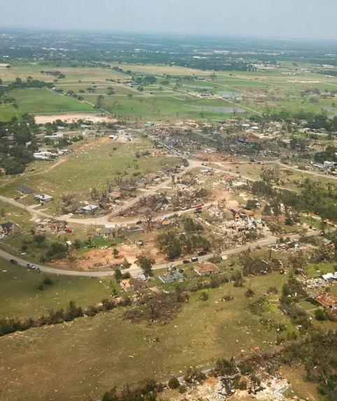
More on EF4 Tornado in Granbury, TX
On Wednesday evening, there was
16 confirmed tornadoes across northern Texas, one of which was rated an
EF4 in Granbury, TX. The image below from the National Weather Service
out of Ft. Worth, TX (Courtesy Texas State Police) shows the aerial view
of the damage. If you look close, you can actually see some of the
homes completely wiped off of their foundation.
...NWS DAMAGE SURVEYS FOR 05/15/2013 TORNADO EVENT...
...16 TORNADOES HAVE NOW BEEN CONFIRMED. ALL SURVEY CREWS HAVE
RETURNED FOR THE DAY AND SOME OF THEIR INFORMATION HAS BEEN
INCLUDED IN THIS UPDATE...
SO FAR 16 TORNADOES HAVE BEEN CONFIRMED. THE FIRST TORNADO
OCCURRED IN MONTAGUE COUNTY AT 538 PM CDT. THE LAST REPORTED
TORNADO WAS AROUND 1210 AM IN ENNIS.
THIS INFORMATION IS CONSIDERED PRELIMINARY. SURVEY TEAMS WERE
SENT TO JOHNSON COUNTY...HOOD COUNTY...PARKER COUNTY...ELLIS
COUNTY AND MONTAGUE COUNTY. OVER THE NEXT FEW DAYS WE WILL
CONTINUE TO COLLECT DATA...TALK WITH EMERGENCY OFFICIALS AND
RESPONDERS...AND EYE WITNESSES...REVIEW RADAR DATA...PICTURES AND
VIDEOS. THE INFORMATION CONTAINED IN THIS REPORT IS SUBJECT TO AND
LIKELY WILL CHANGE.
========================================
.TORNADO #5 - GRANBURY/HOOD COUNTY...
RATING: EF-4
PATH LENGTH /STATUTE/: 2.75 MILES
PATH WIDTH /MAXIMUM/: 880 YARDS/0.5 MILES
FATALITIES: 6
INJURIES: DOZENS
SIGNIFICANT DAMAGE OCCURRED WITH THIS TORNADO INCLUDING HOMES WIPED
CLEAR OFF THE FOUNDATION. TWO HOMES SUFFERED EF-4 MAGNITUDE DAMAGE
AND SEVERAL MORE SUFFERED EF-3 MAGNITUDE DAMAGE. ADDITIONAL
INFORMATION ON THIS TORNADO WILL BE PROVIDED LATER.
Raw Video of Damage From EF4 Granbury, TX Tornado
Here's some aerial damage video over Grandbury, TX.
"Forecasters say the tornado that claimed
six lives and destroyed dozens of homes in North Texas is believed to
have had winds up to 200 mph. (May 16)"

Wind Map (Bookmark Worthy)
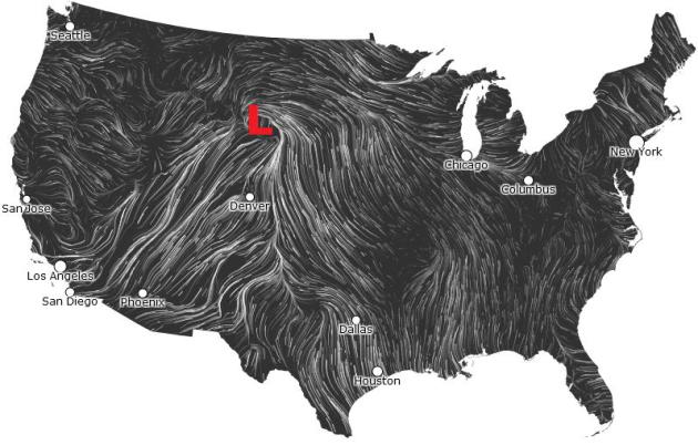
This is a bookmark worthy website for you if you're interested. I tend to pull this map anytime there are storm system rolling through the country. It does a pretty good with surface features; i.e. fronts/highs/lows/etc. Note the counterclockwise rotation in the wind field across the High Plains. This is the developing low pressure system that will create strong to severe weather potential across the middle part of the country over the next few days.
See the animating website HERE:
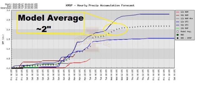
MSP Rainfall Potential
A slow moving Pacific storm
system will generate several rounds of showers and storms through next
week. This will bring heavy rainfall potential to the Twin Cities
through next week as well. The image below suggests a model average
rainfall of nearly 2" by midweek next week.
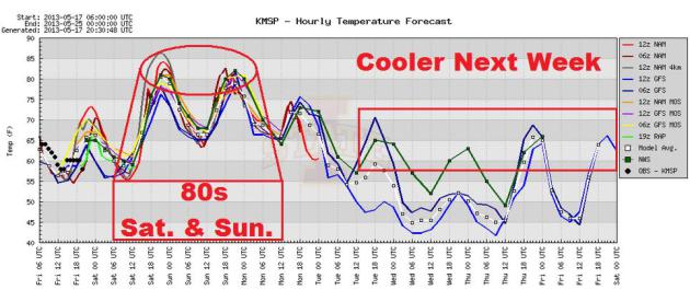
Warm & Sticky Weekend?
This slow moving storm will also churn up some warmer and stickier air across the Upper Midwest. MSP should see temps in the lower 80s both Saturday and Sunday with dew points in the lower 60s. Next week, temps should fall into the 60s as the storm sits nearly on top of us!
Thanks for checking in, have a great weekend.
Don't forget to follow me on Twitter @TNelsonWNTV

No comments:
Post a Comment