76 F. high yesterday in Minneapolis - St. Paul.
67 F. average high on May 6.
64 F. high on May 6, 2012.
67.7" snow so far this winter in the Twin Cities - 13.3" above average. Yes, I think that's it. Check back in a week or two.
70s today - warmest day of the next 5 days.
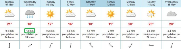
Wednesday appears to be the wettest day: showers and a few T-showers.
50s Fishing Opener Saturday, winds gusting to 25.
Dry and sunny for Mother's Day and Race For The Cure Sunday.
Perfect
Finally. I can walk down the street without
small children cowering in fear. Their parents are waving again (with
all their fingers). I've been here since 1983 - this is the latest I can
remember spring green-up. I'll never take GREEN for granted again.
Speaking of weather whiplash: last year set a
record for the earliest ice-out on record for many Minnesota lakes; this
year will be one of the latest. Lakes are still ice-covered from Mille
Lacs, Gull & Whitefish on north to the Canadian border. Ice-out may
be 2-5 days later than 1996; most central Minnesota lakes opening up by
Saturday, but northern lakes? Keep your boating expectations low.
I wish I could write you a prescription &
send you home early today: blue sky, light winds, no humidity or bugs.
As good as it gets.
A cold swirl in the atmosphere pushes showers
& T-storms into town tomorrow; dew points and wind shear values not
high enough for a widespread severe outbreak.
A vigorous cold front arrives with showers by
Friday night. Saturday looks brisk with 50s and jackets, but no
accumulating snow! Mother's Day looks better; more sun & less wind -
highs close to 60F. We may top 80 early next week.
More whiplash.
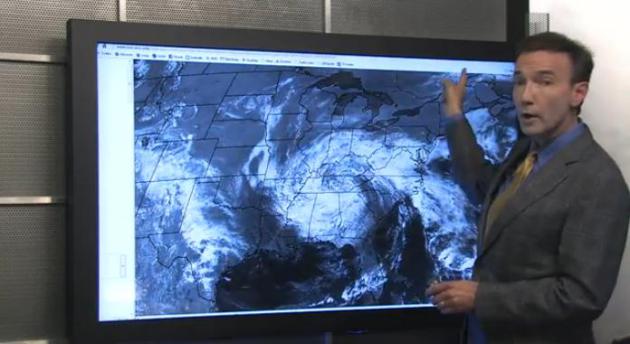
A Race Against Time. Cue the scary opening
music: duh duh....duh. Will there be ice on northern Minnesota lakes for
the Fishing Opener? Probably, although it may be off just in time at
Mille Lacs, possibly Gull and Pelican. The midday Monday 1,000 meter
NASA "Terra" satellite image shows ice-free lakes south of a line from
Little Falls to Hinckley. But as you can see Mille Lacs, the Whitefish
Chain and Leech are still covered in ice. Mild weather today and midweek
rain will help to accelerate ice-out, but I have my doubts Park Rapids
lakes will be ice-free in time for Gov. Dayton's big visit. At this rate
he may have to drop by the local Coborn's and pick up some nice walleye
filets. Can you say "improvise"?
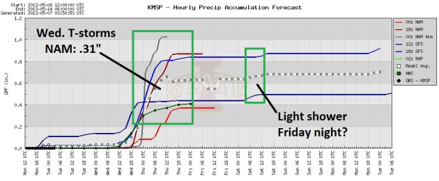
Midweek Puddle Potential. The 00z NAM prints out
.31" (all rain!) with showers spilling over into Thursday morning.
Friday looks dry, only a fleeting light shower or two Friday night -
probably not enough rain to seriously interfere with fishing.
Stuck Storms and Lazy Fronts. The ultra-slow-moving
cut-off low grinding up the East Coast is acting as an atmospheric road
block, slowing down the next upper level disturbance for the Upper
Midwest. Showers and a few T-storms are likely here Wednesday into
Thursday morning, then drier by late week, in spite of a cold frontal
passage Friday night. Any weekend chill should be fleeting, a quick
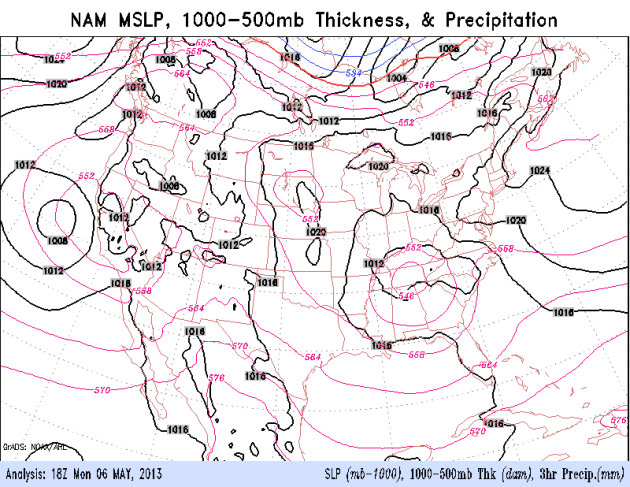
warming trend starts up again on Mother's Day. NAM model data: NOAA.
Visions Of A (Real) Spring. Today should be the
mildest day into at least Sunday; low to mid 70s likely under a partly
sunny sky. Wednesday still appears to be the wettest day, showery,
convective rains: showers and a few heavier T-storms possible. After a
wet start skies brighten Thursday, another shower Friday night as colder
air approaches. Highs hold in the 50s Saturday (maybe some 40s far
north - pack a sturdy jacket), but a quick temperature rebound is likely
early next week.
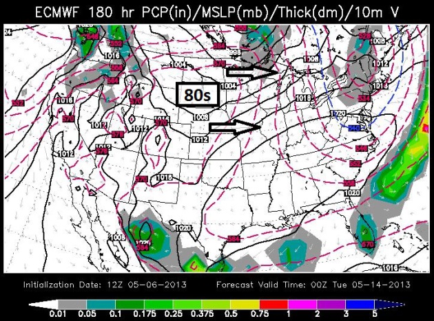
Why I'm Going Warmer Monday - Tuesday. Even the
normally trusty ECMWF (European) has been more erratic than usual as of
late, as the atmosphere makes up its mind whether it wants to stay in
winter-mode or graduate to spring. But we've had a few runs/row now
pulling very warm air across the Rockies and Plains into Minnesota early
next week. If this forecast verifies we'll see highs at or above 80F
the first half of next week.
The Cut-Off Low That Has Much Of America In A Weather Rut.
The same slow-motion storm that dumped historic amounts of snow on
southeastern Minnesota, western Wisconsin and parts of Iowa is now
soaking much of the Southeast and Mid Atlantic Region. In recent days
weather systems have stalled, cut off from the main belt of westerly jet
stream winds. More details in today's edition of
Climate Matters: "
It's
been incredibly wet in the Southeast and Mid Atlantic. Rainfall
records are breaking from Key West to Atlanta and Charlotte. For folks
in the moisture starved Southwest, raindrops today have been a welcome
sight. Meteorologist Paul Douglas explains what he calls continued
weather whiplash."
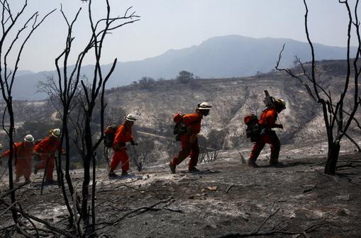
California Girds For Severe Fire Season As Dry Land Burns.
California experienced the 4th driest winter rainfall season on record,
which doesn't bode well for the fire season to come (which usually
peaks in late summer and autumn).
Bloomberg has the story; here's an excerpt: "
Californians
are preparing for a prolonged season of wildfires after an unusually
dry winter that left millions of acres of scrub brush in the most
populous U.S. state primed to burn. The tinder-box conditions have
sparked more than 840 wildfires
since January, about 320 more than the five-year average, according to
the state Forestry and Fire Protection Department, known as Cal Fire. A
fast-moving fire in Ventura County over the weekend charred an area the
size of San Francisco, forced the evacuation of a college with 4,900 students and threatened 4,000 homes northwest of Los Angeles..."
Photo credit above: "
A crew of firefighters climb through a
burned area looking for hot spots in Hidden Valley, California, on
Saturday, May 4, 2013. Rising humidity and cooling temperatures have
slowed the massive fire on its third day." (Anne Cusack/Los Angeles Times/MCT
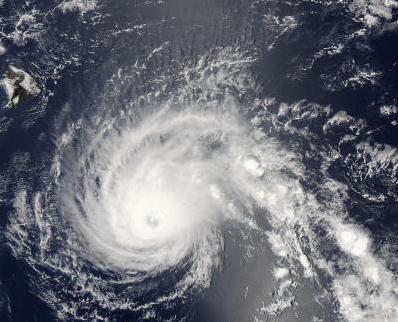
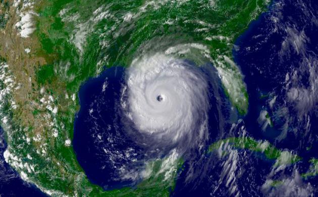
More Hurricanes For Hawaii? Warmer water and a shift in weather patterns may increase overall risk for Hawaii, according to this story at
Science Codex; here's an excerpt: "
News
of a hurricane threat sends our hearts racing, glues us to the
Internet for updates, and makes us rush to the store to stock up on
staples. Hawaii, fortunately, has been largely free from these violent
storms in the recent past, only two having made landfall in more than 30
years. Now a study headed by a team of scientists at the International
Pacific Research Center, University of Hawaii at Manoa, shows that
Hawaii could see a two-to-three-fold increase in tropical cyclones by
the last quarter of this century. The study, which appears in the May 5,
2013, online issue of Nature Climate Change, though, leaves open the
question, how worried Island residents should get. "Computer models run
with global warming scenarios generally project a decrease in tropical
cyclones worldwide. This, though, may not be what will happen with
local communities," says lead author Hiroyuki Murakami..."
Image credit above: "
Hurricane Flossie is approaching the Big Island of Hawaii in August 2007." (Photo Credit: NASA)
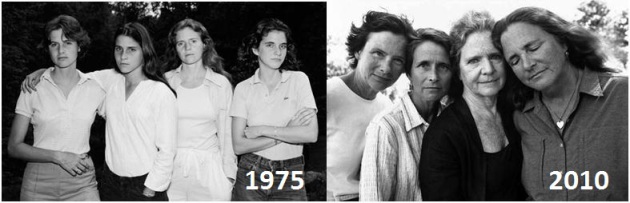
These Four Sisters Were Photographed Every Year For 36 Years. What a wonderful idea - this story from
sobadsogood.com resonated with me; here's an excerpt: "
The
year was 1975 when Nicolas Nixon, a professor of photography at the
Massachusetts College of Art originally photographed his wife Bebe and
her 3 sisters. They were so impressed with the result, they collectively
decided to make it a yearly event, the annual family photo. 36 years
later, the sisters and Nicolas had all kept their promise, resulting in
these 36 beautiful and candid photographs..."
Experience: "I Was Swallowed By A Hippo". A headline you don't see very often, if ever - details from
The Guardian: "
The
hippo who tried to kill me wasn't a stranger – he and I had met before
a number of times. I was 27 and owned a business taking clients down
the Zambezi river near Victoria Falls. I'd been working this stretch of
river for years, and the grouchy old two-ton bull had carried out the
occasional half-hearted attack. I'd learned to avoid him. Hippos are
territorial and I knew where he was most likely to be at any given
time. That day I'd taken clients out with three apprentice guides –
Mike, Ben and Evans – all in kayaks. We were near the end of the tour,
the light was softening and we were taking in the tranquillity. The
solid whack I felt behind me took me by surprise..."
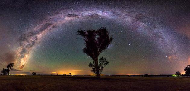
17 Astrophotographs That Will Take You On A Time Warp Through Space. Astronomy buffs should enjoy this photo essay, courtesy of
dashburst.com: "
The stars are out in full force tonight. Previously, we've featured the amazing star trail photography of Lincoln Harrison,
an astrophotographer extraordinaire, based out of Victoria, Australia.
We humans have always had a fascination with the stars and sky above
us, but Lincoln's work takes this to a whole new extreme. Our galaxy
reflects light on our universe's past. And his exposures are so long and
detailed, if you stare at them for awhile you'll feel like you've
started warping through space and time as if you just embarked on some
type of epic Star Trek mission!"
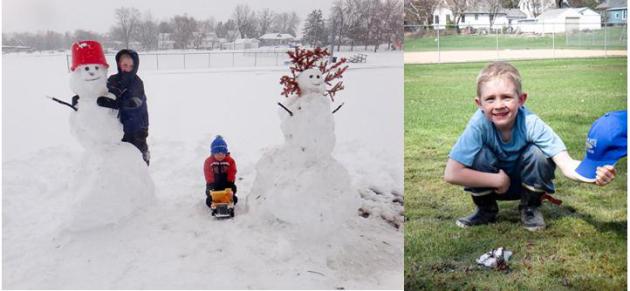
A Snowman's Rapid Demise. Thanks to Andrew and Jill
Dahl (hey, any relation to...never mind) for sending in these before and
after photos from southeastern Minnesota. The photo upper left was
taken Thursday, May 2. The photo on the right was taken just 96 hours
later. This has to be some sort of record for the fastest snowman
meltdown on record.
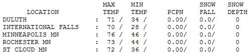
A Little Ice With Your Warm Front? It must have been
a little surreal yesterday up north; highs hit 70 at International
Falls and 71 at Duluth, with thick ice still on local lakes. Hey, the
best of two seasons! A cold wind off Superior kept Grand Marais
residents in jackets with a high of 46. St. Cloud saw 72, 74 at Hibbing
and 76 in the Twin Cities.
TODAY: Perfect. Warm sunshine. Winds: South 5-10. High: 76
TUESDAY NIGHT: Clouds increase, chance of a shower or T-shower late. Low: 55
WEDNESDAY: Showers likely, possible T-storm. High: near 70
THURSDAY: Mostly cloudy, a bit cooler. Wake-up: 54. High: 64
FRIDAY: Partly sunny, nighttime showers. Wake-up: 43. High: 66
SATURDAY: Windy and cooler with intervals of sun, light jackets. Wake-up: 45. High: 55
MOTHER'S DAY: Chilly start, milder finish. Sunny skies. Wake-up: 37. High: near 60
MONDAY: Instant summer. Turn on the A/C? Wake-up: 46. High: near 80
Climate Stories....
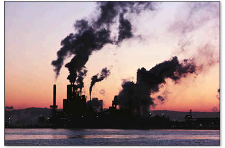
With Carbon Dioxide Approaching A New High, Scientists Sound The Alarm. 400 ppm. Here's an excerpt from
The International Herald Tribune: "
For the first time in human history, atmospheric carbon dioxide levels will surpass 400 parts per million, according Scripps Institution of Oceanography, which has been measuring carbon dioxide in the atmosphere at the Mauna Loa volcano in Hawaii
since 1958. “The 400-ppm threshold is a sobering milestone, and should
serve as a wake-up call for all of us to support clean energy
technology and reduce emissions of greenhouse gases, before it’s too
late for our children and grandchildren,” said Tim Lueker of the
Scripps Institution in a statement. The level of carbon dioxide in the
atmosphere is closely linked to global warming. The more carbon
dioxide, the higher global average temperatures have climbed, according
to climate science. (This graphic shows how global temperature and atmospheric carbon dioxide levels have been linked in the past 400,000 years)..."
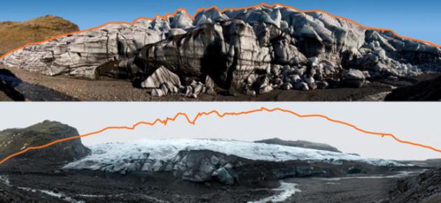
Arctic Melting Rapidly: Action Needed Now. If you
haven't seen the documentary "Chasing Ice" - and you still have an open
mind about climate change, spend the time, make the effort to see this
film. It may change the way you feel about this subject. Some people
still don't trust climate scientists. Hopefully they'll believe their
own eyes. Here's an excerpt from a
Huffington Post story: "
The Arctic sea ice is melting at a phenomenal rate and the London-based Arctic Methane Emergency Group (AMEG)
is calling for governments to put two and two together, and pull out
all stops to save the Arctic sea ice or humankind will face starvation
in the ensuing years ahead. This week, the White House will hear
evidence from Australian scientist, Carlos Duarte, that the Arctic sea
ice is on such a downward spiral that we may see a dramatic decline of sea ice over the next two years. Evidence
was given to the UK government last year from British scientists,
Peter Wadhams and John Nissen, that we could see minimal sea ice by
September 2015, simply extrapolating the sea ice volume trend.
Evidence from recent satellite images suggests that a record melt is in
progress this year. The plight of the Arctic was highlighted
to British MPs and the Met Office in a recent showing of the film
"Chasing Ice" at the House of Commons, London. The Arctic has recently
become an issue in the European Parliament..."
Suit Claiming Hurricane Katrina Related To Global Warming Goes Before Appeals Court.
Think Philip Morris (time 10,000). Nothing diminishes shareholder
confidence in fossil fuel companies faster than class action lawsuits.
Can the plaintiffs prove that higher greenhouse gas levels (and warmer
water in the Gulf of Mexico) fueled Katrina's explosive intensification
into a Category 4-5 storm in the Gulf of Mexico? Keep an eye on this one
and more to come; details from
The Louisiana Record: "
The
U.S Court of Appeals for the Fifth Circuit is set to issue its second
opinion in a drawn out climate change case that pits landowners against
energy companies. The suit, which accuses a number of companies of
contributing to global warming through greenhouse gas emissions, was
originally filed in a Mississippi district court in 2005 just 22 days
after Hurricane Katrina hit. In the original filing, 14 plaintiffs sued
eight named oil companies, 100 unnamed oil and refining companies and
31 coal companies. Through the course of the litigation, electric
utilities and chemical companies have been added as defendants. The
plaintiffs claim that there is a causal relationship between the
emissions, which increased the ferocity of Hurricane Katrina, and the
resulting destruction of their property. Multiple defendants in the suit
moved for a dismissal, alleging that the plaintiffs lacked standing
and that their claims presented nonjusticiable political questions..."
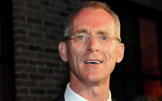
Bob Ingliss Going The Distance On Carbon Emissions Tax.
Bob Ingliss is a notable Republican, which makes his initiative
significant. He proposes putting a price on greenhouse gas pollution,
but in a way that is revenue neutral; a way that stimulates the economy
without growing the size of government. Here's an excerpt from
Politico: "
Former
Rep. Bob Inglis knows that his devotion to a carbon tax might have cost
him his job. But the South Carolina Republican has no regrets as he
dedicates his post-congressional career as well to the battle to
persuade fellow conservatives to embrace a revenue-neutral carbon tax.
“And really, I am the worst commercial for this, because I got my head
blown off trying to do it,” he told POLITICO, sitting at a coffee shop a
short walk from the Capitol. But he added, “Losing an election is not
the worst thing that can happen to you. Losing your soul is
considerably worse.” The controversial tax proposal has long won the
backing of many economists, who say it is the simplest and purest means
of reducing emissions blamed for contributing to climate change. And
while it has also won tentative backing from oil giants like Shell and
ExxonMobil, it’s been pilloried by many oil-state politicians and
conservatives, who say it would raise energy costs and hurt fossil fuel
industries..."


No comments:
Post a Comment