82 F. high in the Twin Cities Friday.
81 F. average high for June 21.
77 F. high on June 21, 2012.
1.95" rain as of 7 pm.
Flash Flood Watch in effect thru at least this morning.
Monsoon Season
I'm heading down to the lake, wearing my suit of
armor, a portable lightning sensor on my helmet - praying out loud I
don't get blown into the next county. June is the wettest, most severe
month of the year in Minnesota, and lately that isn't hard to believe.
On average weather systems limp along at 15-25
mph this time of year. But when storms or fronts stall, that's when
thunderstorms can regenerate over the same counties, increasing the risk
of flash flooding.
One tip: gauge the severity of a storm by the
amount of lightning. Almost continuous flashes moving in? Odds are high
the storm is severe.
A fickle warm frontal boundary will throw a
series of loud parties for consenting cumulonimbus clouds through the
weekend with enough midday/PM sun for 80s. If the sun stays out a few
hours 90F is possible closer to home. A few severe storms are likely
today & Sunday. Stay alert and don't push the weather. Mother Nature
always gets the last laugh.
Last summer the Twin Cities enjoyed 31 days
above 90F. This year: 10-14 days above 90? Dr. Mark Seeley says the
eruption of Mt. Pinatubo sparked a Summer Solstice FROST across much of
Minnesota in 1992.
Yes, things could be worse.
* photo above courtesy of Michael Thompson down at Twin Cities International Airport.
* Flash Flood Watch in effect for most of central and southern Minnesota thru Saturday morning.
Multi-Million Dollar Storm? That's a
WAG on my part, but based on some of the photos I'm seeing, and the
scope of the straight-line winds that blew thru, I suspect damage will
run into the (many) millions of dollars from today's rain and wind.
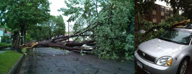
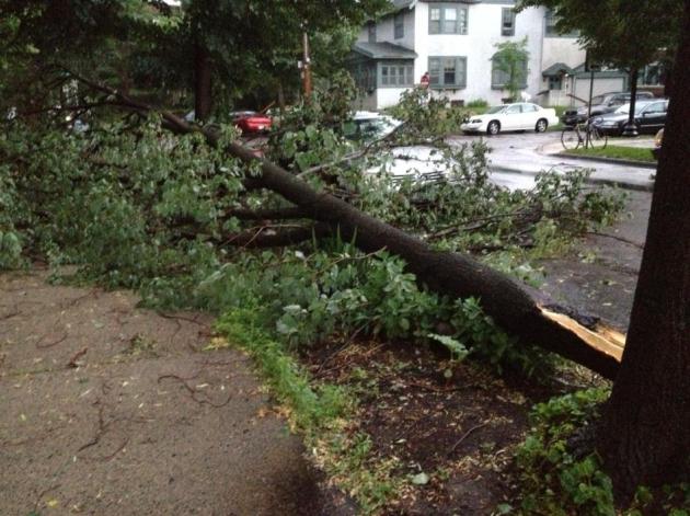
There's no evidence of tornadic winds,
but straight-line winds were strong enough (60-80 mph) to bring down
big trees. Photo from South Minneapolis (upper right) courtesy of
Dominic Hanzely. Photo from Uptown (upper right) from Walt Kruhoeffer.
Big Trees Down. Walt Kruhoeffer sent in this photo from Uptown, the scene right outside his apartment window - big trees down, still no power.
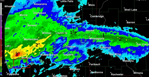
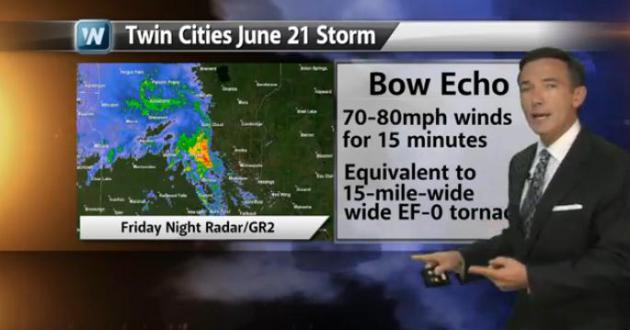
Serious Flash Flood Potential These are Doppler
radar estimates of rainfall amounts from the severe supercell that
pushed across the metro area between 6:30 and 8 pm Friday, whipping up
70+ mph (straight-line) winds. Ground already saturated from early
morning storms made it easier for trees to topple over, and there are
numerous reports of trees down across the metro area from this severe
storm. NO EVIDENCE OF A METRO TORNADO. I suspect these were almost
entirely straight-line winds from a small, compact, derecho-like severe
storm. These are rainfall amounts as of 10:45 pm.
Widespread Water & Wind Damage. I drove into
yesterday evening's severe storm after appearing on TPT Almanac. It was
like driving into a 15 minute hurricane, total white-out, like being in
a warm weather blizzard, waves of wind buffeting vehicles, many
drivers parked under bridges on I-394. I saw numerous (big) trees down,
many roads blocked, too many power outages to count and street lights
out. What a mess.
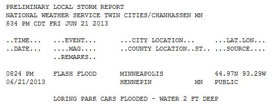
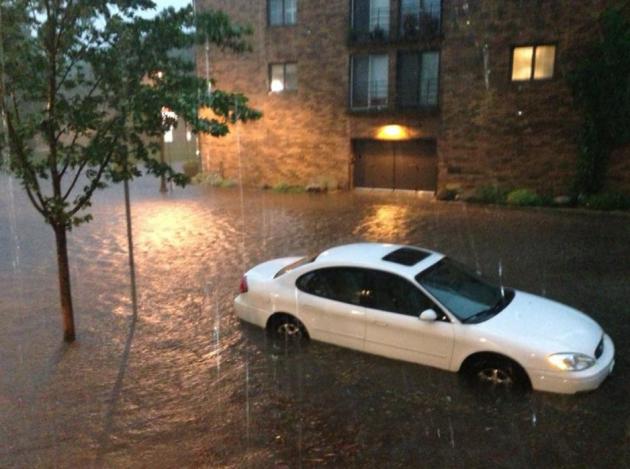
Flash Flood. Lee Huffman sent me this photo from the
Loring Park, Minneapolis area this evening, about 2-3 feet of water
overwhelming vehicles and people just trying to wade thru the
instant-flood.
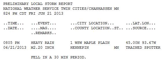
Incredible Rains. 2.2" of rain in 30 minutes in
Maple Plain. That's 2 week's worth. It shows you how much water is
floating overhead. Any rain from additional storms will immediately run
off into streets, streams and basements. If you often experience spring
flooding you may have a long weekend ahead of you.
*
Click here for the latest damage metro reports from NOAA.
From Friday morning's severe storm outbreak between 3 and 6 am:
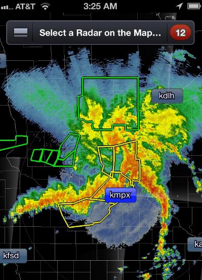
A Monstrous Swirl. On my
smartphone Doppler display at 3:25 AM it looked like a miniature storm
system with the advancing warm front, trailing cool front and comma head
with steadier/heavier rain. Like every (synoptic scale) storm every
MCS (meso-convective system) is different. Last night's storm sparked
60+ mph wind gusts in the metro and over 1-2" rain in some communities.
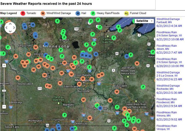
Friday Morning Severe Weather Reports. The MCS
system that blasted across the state during the overnight hours produced
wind damage, along with hail and flash flooding (and nearly continuous
lightning at times). Here's an interactive map and more details on
damage across Minnesota and Wisconsin from the
Twin Cities NWS office.
Monsoon Season. Dr. Mark Seeley has more details on excessive rains early Friday in his WeatherTalk Newsletter: "
A
Mesoscale Convection System (MCS) brought severe weather to the state
overnight during Thursday and Friday this week (June 20-21). This
complex of thunderstorms produced some hail that ranged from 1 inch to
one and three-quarter inch diameter, along with some wind gusts from
60-85 mph, especially in western and central parts of the state where
many trees were damage. There were numerous power outages reported,
along with some very heavy rainfalls that caused flash flooding in a
several Minnesota counties. Many roads were closed for a time. Some of
the rainfall amounts reported included..."
3.56 inches at Hawley
3.41 inches at Sandstone
3.73 inches at Little Falls
2.63 inches at Brainerd
2.57 inches at Cloquet
2.25 inches at Staples
Peak Winds from Overnight T-storms:
MRSSS - - gust 76 mph at 1:56 a.m. EDT / 12:56 a.m. CDT - - WeatherBug at St. Mary’s School, Morris, MN
KMOX - - gust 68 mph at 1:46 a.m. EDT / 12:46 a.m. CDT - - Municipal Airport in Morris, Minnesota
KCFE - - gust 66 mph at 4:14 a.m. EDT / 3:14 a.m. CDT - - Municipal Airport in Buffalo, Minnesota, USA
SCLOD - - gust 60 mph at 3:39 a.m. EDT / 2:39 a.m. CDT - - WeatherBug at Apollo HS in St. Cloud, MN
STCSD - - gust 60 mph at 3:44 a.m. EDT / 2:44 a.m. CDT - - WeatherBug at St. Cloud State EAS Department
KPNM - - gust 60 mph at 4:11 a.m. EDT / 3:11 a.m. CDT - - Municipal Airport in Princeton, Minnesota, USA
NWRMS - - gust 57 mph at 5:15 a.m. EDT / 4:15 a.m. CDT - - WeatherBug at New Richmond HS in New Richmond, WI
* thanks to James Anan at Earth Networks for providing these reports.
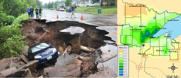
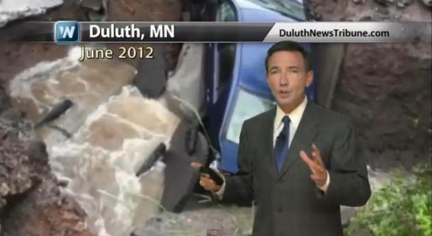
The Duluth Mega-Flood of 2012. Yesterday marked the
one year anniversary of the remarkably destructive flash flood that
struck the Duluth area from June 19-20, 2012. The
Duluth office of the National Weather Service has a very good summary; here's an excerpt: "...
A
swath of impressive rainfall amounts ranging from 5-10 inches fell
over much of the NWS Duluth area of responsibility during the period of
June 19th - 20th. Numerous roads were washed out from the deluge of
rain from Carlton County through the Duluth metro area and into
Douglas County and Bayfield County in Wisconsin. A state of emergency
was declared in Duluth, Hermantown, Cloquet, Barnum, Moose Lake and
Superior, WI. The steep terrain, and numerous creeks and rivers, played a
significant role in the devastating damage and flooding that
occurred in the Duluth community. The Fond Du Lac and West Spirit
Mountain neighborhoods of Duluth and Thomson Township in Carlton
County were evacuated. A raging Kingsbury Creek flooded the Lake
Superior Zoo, drowning over a dozen animals. Two seals were swept
from their enclosures, but were returned safely after being found on a
local street. The polar bear escaped its exhibit, but was safely
returned after being tranquilized by a dart..."
Photo credit upper left: Bob King, Duluth News Tribune.
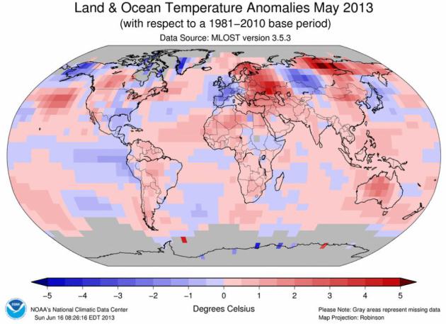
Live Local - Think Global. It was a chilly May (and
spring) across the Upper Midwest and a fairly sizable chunk of the USA,
in fact spring was the first cooler-than-average season in nearly 3
years over the Lower 48 states. But that doesn't mean the rest of the
world is feeling unusual chill. May was tied for 3rd warmest worldwide,
spring was the 8th warmest (land and ocean water temperatures) globally,
according to NOAA NCDC. In other words, don't look out your window and
assume the weather you're experiencing is what's happening (everywhere
else). Details in today's edition of
Climate Matters: "
The
spring of 2013 was colder than average for many across the U.S. But
that was not the story across other parts of the globe. WeatherNation
Chief Meteorologist Paul Douglas looks at the big weather picture."
Historic Floods On The Increase. Increasingly, when
it rains, it pours...and floods. North Dakota, Minnesota, Wisconsin,
Illinois and Michigan each had a top 10 wet spring season in 2013.
Iowa had its wettest spring on record with 17.61 inches of
precipitation. Meteorologist Paul Douglas looks at what may be fueling
the heavy downpours in today's edition of
Climate Matters. Duluth 2012 Flooding video provided by the Duluth News Tribune. Click here for more of their coverage:
http://www.duluthnewstribune.com/even...
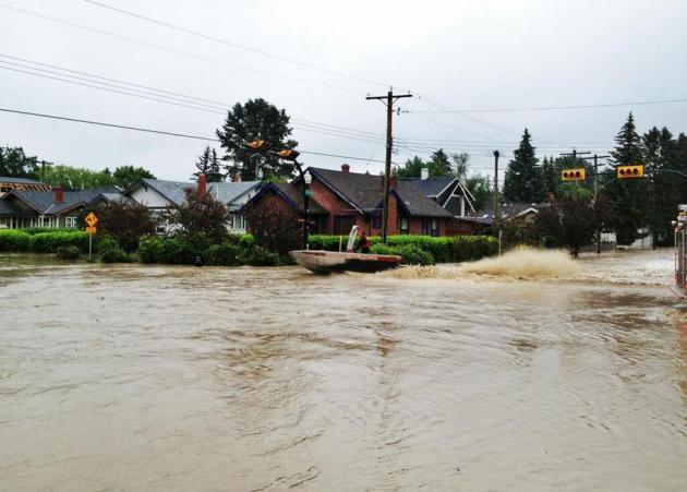
Historic Flooding. Speaking of flooding, residents
of Calgary, Canada are enduring major floods, the worst in decades. As
many as 100,000 people have been impacted by the rapidly rising waters,
with as many as 75,000 evacuations so far. Thanks to Mookalicious, who
snapped and tweeted
this photo from Roxboro, Alberta.
May: Third Warmest On Record, Worldwide. Here's an
excerpt of a comprehensive global summary of May, which was chilly over
Minnesota and parts of Europe. The rest of the planet? Not so much.
Details from
NOAA NCDC:
- The combined average temperature over global land
and ocean surfaces for May 2013 tied with 1998 and 2005 as the third
warmest on record, at 0.66°C (1.19°F) above the 20th century average of 14.8°C (58.6°F).
- The global land surface temperature was 1.11°C (2.00°F) above the 20th
century average of 11.1°C (52.0°F), also the third warmest May on
record. For the ocean, the May global sea surface temperature was
0.49°C (0.88°F) above the 20th century average of 16.3°C (61.3°F), tying with 2003 and 2009 as the fifth warmest May on record.
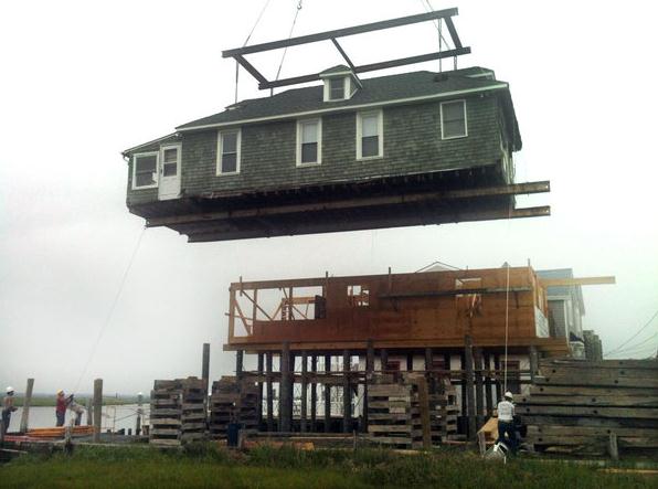
Feds Don't Do Enough To Prepare For Severe Weather, Report Says.
When are we going to stop playing defense and go on offense? But that
requires fixing and strengthening our infrastructure, which requires
money and vision from Washington D.C., which requires Congress to
actually do something. So I'm not holding my breath. The
Los Angeles Times has the article; here's an excerpt: "
Federal
efforts to bolster community preparedness for extreme weather events
are a fraction of what the government spends on cleaning up the
damage from storms, tornadoes and drought, according to a new analysis of federal data by the Center for American Progress,
a left-leaning Washington think tank. The report estimated that from
2011 to 2013, the federal government spent about $136 billion on
weather-related disaster relief and recovery but only $22.4 billion on a
total of 43 preparedness programs, or about $6 in cleanup for every
$1 spent on strengthening defenses or preventing or mitigating
damage. A growing body of climate science indicates that the warming
atmosphere increases the likelihood of extreme weather-related events..."
Photo credit above: "
A home in Sea Isle City, N.J., is moved to an adjoining property to correct damage issues inflicted by Superstorm Sandy."
(Anjalee Khemlani / Associated Press).
We Are Shocked, Shocked. With the recent outcry over NSA overstepping it's bounds by monitoring electronic communications I found this post from David Simon interesting, and pretty much on the money. Here's an excerpt: "Is
it just me or does the entire news media — as well as all the
agitators and self-righteous bloviators on both sides of the aisle — not
understand even the rudiments of electronic intercepts and the
manner in which law enforcement actually uses such intercepts? It
would seem so. Because the national eruption over the rather
inevitable and understandable collection of all raw data involving
telephonic and internet traffic by Americans would suggest that much
of our political commentariat, many of our news gatherers and a lot
of average folk are entirely without a clue. You would think that the
government was listening in to the secrets of 200 million Americans
from the reaction and the hyperbole being tossed about. And you would
think that rather than a legal court order which is an inevitable
consequence of legislation that we drafted and passed, something
illegal had been discovered to the government’s shame. Nope. Nothing
of the kind..."
Image credit: gizmodo.com.
Feeling Paranoid? Here Are 3 Things Actually Worth Worrying About.
Yes, we tend to worry about the wrong things much of the time.
Instead of fixating on terrorism or agonizing over interest rates we
should be far more concerned about the risks caused by a). falling
down, b). our diets, and c). infidelity (not necessarily in that
order). Here's an excerpt from a very interesting story at TPT's
Next Avenue: "...
Too
many Americans, on the other hand, "obsess about the wrong things
and we fail to watch for real dangers," Diamond wrote. We exaggerate
the risk of disasters beyond our control while underestimating risks
we frequently encounter, like showers, night driving or climbing
ladders. It's no wonder. Terror gets exhaustive media coverage 24/7,
even though as we age into midlife and beyond, we face increasing
odds of confronting more commonplace adversities. Perhaps it's time
to direct some constructive paranoia in new directions..."
Image: iStockphoto.
Watch: What Do YOU Want To Do Before You Die. A
morbid topic? Maybe, definitely not something we tend to chat about with
friends or family members, and yet maybe this is a conversation we
should have, at least with ourselves. Here's an excerpt of a post (and
great video) from Candy Cang at
Huffington Post: "...
Contemplating
death, as Stoics and other philosophers encourage, is a powerful tool
to re-appreciate the present and remember what makes your life
meaningful to you. We're all trying to make sense of our lives and
there's great comfort in knowing you're not alone. Everyone you're
standing with in line and everyone you're sitting by in a cafe and
everyone you walk past on the street is going through challenges in
their life. Yet it's easy to forget this because we rarely venture
beyond small talk with strangers. There are a lot of barriers to
opening up..."
Photo credit above: Townsville, Australia. Credit: Kim Kamo.
8 Foods We Eat In The U.S. That Are Banned In Other Countries. This article at
buzzfeed.com made me do a triple-take, and examine the brightly colored foods on
my desk. Yuck. Here's a snippet that may make you go vegan:
Artificial food dye: Makes your food pretty and inhibits nerve-cell development.
Found in: Practically everything we eat: cake mixes, sports drinks, cheese, candy, and even MACARONI AND CHEESE.
Why it’s dangerous: Artificial dyes are made from chemicals
derived from PETROLEUM, which is also used to make gasoline, diesel
fuel, asphalt, and TAR! Artificial dyes have been linked to brain
cancer, nerve-cell deterioration, and hyperactivity, just to name a
few.
Where it’s banned: Norway, Finland, Austria, France, and the United Kingdom.
For more information on artificial dyes, visit
100 Days of Real Food.
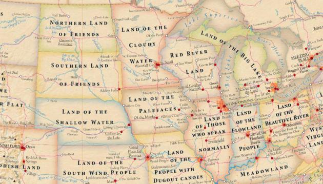
Land Of The Cloudy Water. That's the literal
translation of "Minnesota", so why don't we call it that? Waterfall City
sounds better than Stink Onion (Chicago) or Sibling Love
(Philadelphia). Good grief. Here's an excerpt of an eye-opening nugget
from
Slate: "
It’s
easy to think of words such as California or Texas or New York as just
the places on the map, but those words actually meant something, once,
and those meanings offer a little glimpse into history. The above map,
designed by cartographers Stephan Hormes and Silke Peust,
labels states, cities, and landmarks with the literal meanings of their
official names. Most of the meanings are bland descriptions of the
terrain or climate of the places they describe. Michigan, for example,
is the “Land of the Big Lakes” (duh), and Mississippi is the “Land of
the Great River.” Others carry baffling specificity, like Alabama’s
“Land of the Thicket Clearers” or Missouri’s “Land of the People with
Dugout Canoes....”
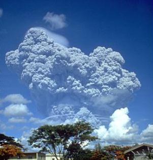
Summer Solstice Frost of 1992. I had forgotten about
this freakish weather event on June 21, 1992 - linked to the Mt.
Pinatubo volcanic eruption, which had a temporary cooling effect
worldwide. Dr. Mark Seeley has more details in this week's edition of
WeatherTalk; here's an excerpt: "
This
date is a memorable one in Minnesota history as the only summer
solstice that brought damage frost to the state's corn and soybean
crops. The Mt Pinatubo eruption in the Philippines during 1991 was
later attributed to be one of the causes of this event which turned out
to a singularity in Minnesota's climate history. Temperatures as cold
as 25 degrees F (Brimson) were reported in the north, but even as far
south as Preston, Theilman and Zumbrota reported 33 degrees F with frost
in low spots. Some corn fields were severely damaged and later only
harvested for silage. Soybeans leaves mostly burned by the frost
recovered and produced even pods and beans for harvest, but the yields
were not very good..." (image of Mt. Pinatubo courtesy of Wikipedia).
Putting Blizzard To Work. Here's a great photo from St. Cloud State University's
Facebook page: "
Blizzard pitches in with clean-up following this morning's straight-line winds. The Husky is, after all, is a working breed."
TODAY: Flash Flood Watch. Steamy, few strong to severe T-storms. Dew point: 74. Winds: S 10-15. High: near 90
SATURDAY NIGHT: More T-storms, best chance central and northern Minnesota. Localized flooding possible. Low: 72
SUNDAY: Isolated shower or T-storm, turning drier, sunnier, and a bit less humid by late afternoon. High: 86
MONDAY: Hot sun, a bit drier. Wake-up: 70. High: 90
TUESDAY: Hot and sticky, early thunder? Wake-up: 72. High: 89
WEDNESDAY: Muggy, few T-storms. Dew point: 71. Wake-up: 73. High: near 90
THURSDAY: More sun, less humidity. Dew point: 64. Wake-up: 70. High: 88
FRIDAY: Blue sky, breathing easier. Dew point: 61. Wake-up: 67. High: 85
Climate Stories...
Obama Speech On U.S. Climate Measures Could Come Tuesday: Sources.
Reuters has more details: "
President Barack Obama
is likely to roll out a number of measures on climate policy,
potentially including a strategy to limit greenhouse gas emissions from
existing power plants, in a speech on Tuesday, sources familiar with
the plans told Reuters. The
potential move on power utilities, which account for roughly 40
percent of the nation's carbon dioxide emissions, will come as Obama
sets the fight to curb climate change as a priority for his second
term. Regulations are still pending on
yet-to-be-built power plants, after the Environmental Protection Agency
in April missed a deadline to roll out emissions rules.
But environmentalists have been pushing the administration to go after
a bigger target, and set tighter standards for the roughly 1,400
coal-fired burners that are already feeding the nation's electric grid..."
Climate Change "Will Increasingly Affect Businesses". Here's the intro to a story from
Environmental Management & Energy News: "
Extreme
weather events, water scarcity, biodiversity loss and other global
warming-related changes in the environment will increasingly affect
businesses and how they operate, according to a report released by the
United Nations Environment Programme. The report, GEO-5 for Business: Impacts of a Changing Environment on the Corporate Sector,
says the private sector’s operating costs, markets for products and
availability of raw materials will be affected by climate change.
Businesses that adapt by developing goods and services that can reduce
the impacts of climate change,
water scarcity and emissions as well as seize the demand for
sustainable technologies, investments and services will be successful,
the report says..."
Obama To Tap Executive Powers To Curb Emissions Blamed For Global Warming. Here's the intro to a story from AP and
The Washington Post: "
President
Barack Obama is planning a major push using executive powers to
tackle the pollution blamed for global warming in an effort to make
good on promises he made at the start of his second term. “We know we
have to do more — and we will do more,” Obama said Wednesday in
Berlin. Obama’s senior energy and climate adviser, Heather Zichal, said
the plan would boost energy efficiency of appliances and buildings,
expand renewable energy and use the Environmental Protection Agency’s
authority under the Clean Air Act to regulate heat-trapping
pollution from coal-fired power plants..."
Photo credit above:
Pablo Martinez Monsivais/Associated Press. "President
Barack Obama speaks in front of the iconic Brandenburg Gate in
Berlin Germany, Wednesday, June 19, 2013. Obama is planning a major
push using executive powers to tackle the pollution blamed for global
warming in an effort to make good on promises he made at the start
of his second term. “We know we have to do more — and we will do
more,” Obama said in Berlin."
Campaign For Climate Resilience Spreads Across U.S. Meteorologist Andrew Freedman has the story at
Climate Central; here's the introduction: "
In the wake of New York Mayor Michael Bloomberg’s announcement of a $19.5 billion plan to make the Big Apple better prepared for future extreme weather events on the scale of Hurricane Sandy,
dozens of other cities and counties in the U.S. are showing
increased interest in pursuing so-called “climate resilience” plans.
On Tuesday, 45 local elected officials from cities A (Ann Arbor) to W
(Washington, D.C.) signed on to a new campaign called Resilient Communities for America
to share information and take actions that would bolster their
communities against the multifaceted challenges posed by global climate
change, including more frequent and severe extreme weather events
and, in coastal cities, sea level rise..."
Photo credit above: "
New
York Mayor Michael Bloomberg announced changes to the city's
building code to make buildings more resilient to extreme weather
events." Credit: Spencer T. Tucker, NYC.gov.


No comments:
Post a Comment