82 F. high in the Twin Cities Saturday (clouds lingered longer, keeping us cooler).
81 F. average high on June 22.
81 F. high on June 22, 2012.
Flash Flood risk this morning.
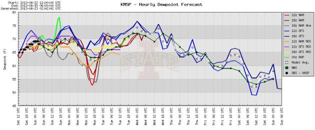
Dew points top 70 the next few days, dropping off into the 50s by late week.
70-degree temperatures by next weekend?
Weather Trauma and Drama
"Why does God hate us?" texted my friend,
Jordana, right after Friday evening's mini-hurricane. I'm pretty sure
that's not the case, but Mother Nature's bite has been extra-savage in
recent months; snow in early May, now artillery blasts of severe weather
able to knock us back to the 19th century in the blink of an eye. I'm
one of many suffering from an increasingly common form of meteorological
PTSD. Friday was a traumatic weather experience for many of us. I will
forever remember the thicket ofvehicles parked under bridges on I-394,
and weaving around downed trees and powerlines, praying my car wouldn't
suddenly take on the characteristics of a boat.
Friday was a head-shaking moment for me. After
discussing climate change on TPT "Almanac"; how a 4 percent increase in
water vapor is spiking summer rains & increasing flash floods (four
1-in-1000 year floods since 2004 just in Minnesota) I drove home from
St. Paul - right into one of these super-sized severe storms:
hurricane-force gusts, white-out conditions with waves of horizontal
rain. Instant flood. Navigating around waves and downed trees, I was
grateful to get home 2 hours late. Everyone has a story to tell about
Friday evening's bow echo.
I can't remember more Twin Cities residents
without power, at least in the 30 years I've been here. This severe
storm may have been unprecedented in that regard.
Saturated soil made it easier for big trees to
come down. T-storms bubble up today (best chance early AM hours) but
with the exception of Tuesday most of the upcoming week looks dry. Highs
may hit 90 by midweek, followed by cooler, more comfortable air late
week.
Dry, sunny weather next weekend? For now it's just a rumor, but we're due for a nice (sunny, blue-sky) weekend.
* photo of a sinkhole in Robbinsdale, resulting from Friday evening's severe storm, courtesy of Kellen Bongratz.
Power Outage Updates. I can't remember this many
people in the Twin Cities without power, at least since I got here back
in '83. This may be an unprecedented outage - latest details from
Xcel Energy: "
We
continue to make considerable progress in the restoration effort.
Since the onset of this event 514,100 customers have experienced a
power outage. As of 7 p.m. today we have restored power to 402,500 of
these customers. We are fully dedicating all resources to restore power
to the remaining 111,600 customers. We will have approximately 400 line
crews approaching a total of 1,000 workers to aid in this large
restoration effort. We expect all of these crews to be working
tomorrow. In addition to the field crews, hundreds more employees are
covering phones in the Call Center, dispatching the crews, managing the
delivery of materials and updating communications..."
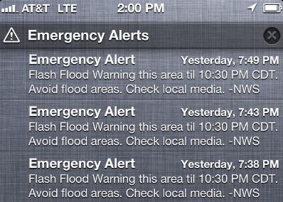 New, Automated Text Warnings
. This is something each wireless carrier is rolling out. I
have
AT&T, and these text alerts popped up automatically Friday evening,
when I was literally inside the severe storm. If you are within the NWS
warning polygon I
think you automatically get
these updates, but check with your carrier, because Verizon, Sprint and
T-Mobile may be doing things a little differently. Another step in the
right direction for warning technology. The more sources, the better.
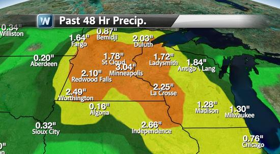
3 Weeks Worth Of Rain In 2 Days. Over 3" for MSP
International and much of the metro since Friday morning, and this was
as of midnight Saturday night. To put that into perspective that's 3
week's worth of rain, in about 36 hours. The ground is (obviously)
saturated, and that created less support for tree roots, increasing the
potential for big trees to come down with Friday evening's sustained
winds of 60-75 mph; close to hurricane force for a period of 10-15
minutes.
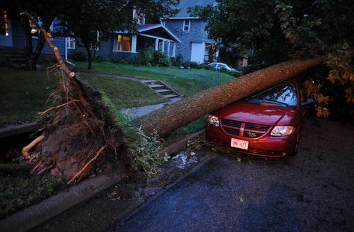
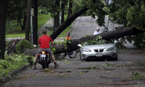
Parking On The Street Just Got Riskier. Talk about
an obscene edition of Russian Roulette, severe-storm edition. Who's car
gets a new sunroof? Place your bets. Photo credit: "
A downed tree
rests on a car on the 1000 block of 21st Ave SE after a wave of severe
storms moved through the area in Minneapolis on June 21, 2013." (Star Tribune/Mark Vancleave, startribune.com).
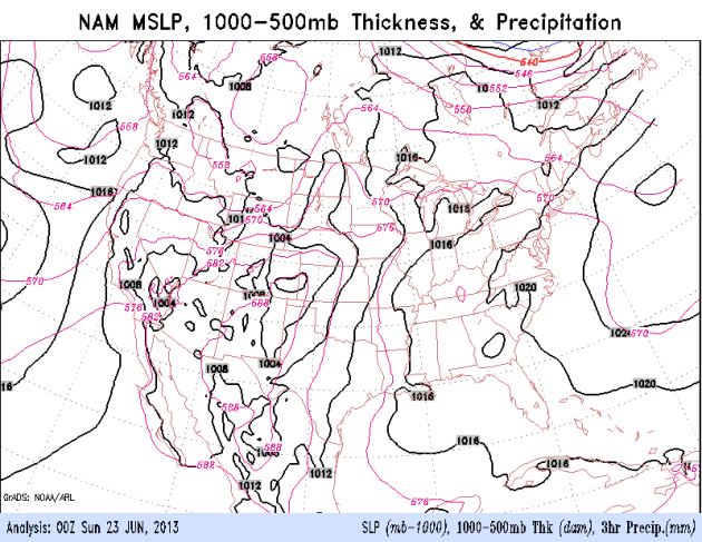 The Weather's "Stuck" Again
.
When fronts or storms stall, bad things often happen. Such is the case
with the current frontal boundary meandering back and forth across
southern Minnesota, provoking waves of heavy to severe thunderstorms,
one swarm after another. T-storms are most likely early Sunday, a few
spotty storms possible Monday and Tuesday, but drier weather is likely
the latter half of the week. 84-hour NAM
courtesy of NOAA.
A Drier Pattern? After a wet day today, and more
heavy showers and T-storms Tuesday into early Wednesday, ECMWF data
suggests drier weather the latter half of next week and next weekend -
with temperatures cooling into the 70s, dew points dropping into the
very comfortable 50s by the end of this week.
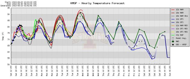
Midweek Heat, Then Cooling. The models are in fairly
good agreement: 80s today and Monday, with a shot at 90 by Tuesday and
Wednesday - temperatures cooling off into the 70s by next weekend.
Sticky Into Midweek. Models show dew points dropping into the 50s by the end of this week; we'll all be breathing easier within 5 days or so.
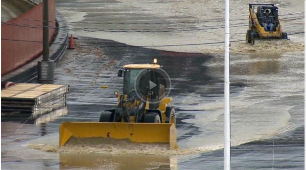 Floods Start To Recede In Calgary, But City Shut Down Until Mid-Week.
 Speaking of record flooding, here's an update from
CTV News: "
Calgary's
downtown core will likely remain closed until at least
mid-week as much of the flood-ravaged city remains under water. Although
both the Bow and Elbow Rivers are expected to recede in the
new 48 hours, flood officials say the downtown area is still under
considerable amount of water and will remain closed until the evacuation
order has been lifted. "The number one thing that I need to share with
all of you is that
we’re still in a state of emergency," Calgary Mayor Naheed Nenshi told
reporters at news conference on Saturday..."
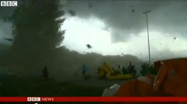 Wild Windstorm In Geneva
. Check out what 130 km. wind gusts in a severe storm did to a sporting event outside Geneva, Switzerland -
video from Sky TV.
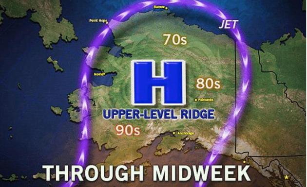
Baked Alaska. You know it's going to be a challenging summer when Alaska is trending (much) hotter than Minnesota.
Think Progress has the story; here's an excerpt: "...
How
hot is it up north? It was so hot that Talkeetna, Alaska hit 96°F on
Monday — warmer than Miami — blowing past the previous record of 91°F
set in June of 1969 (and matched on Sunday). Talkeetna is the city that
the TV show Northern Exposure was supposedly based on. It was so hot
the AP and others simply couldn’t resist headlines like “Baked Alaska:
Unusual Heat Wave Hits 49th State.” It was so hot that Valdez, Alaska
hit 90, smashing the previous all-time record of 87 set in June 1953..."
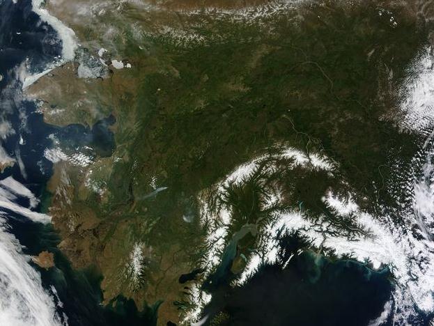
On A Clear Day You Can See....Alaska. The unusually
strong bubble of (hot) high pressure over Alaska is doing something
highly unusual, something that's freaking out many Alaskans: it's
creating clear skies, nearly statewide. Highly unusual. Here's an
excerpt from
seattlepi.com:
"On most days, relentless rivers of clouds wash over Alaska, obscuring
most of the state's 6,640 miles (10,690 kilometers) of coastline and
586,000 square miles (1,518,000 square kilometers) of land. The south
coast of Alaska even has the dubious distinction of being the cloudiest
region of the United States, with some locations averaging more than
340 cloudy days per year. That was certainly not the case on June 17,
2013, the date that the Moderate Resolution Imaging Spectroradiometer
(MODIS) on NASA's Terra satellite acquired this rare, nearly cloud-free
view of the state. The absence of clouds exposed a striking tapestry
of water, ice, land, forests, and even wildfires.
Photo credit above: NASA, Image Credit: NASA/Jeff Schmaltz, LANCE MODIS Rapid Response Team, NASA GSFC Caption: Adam Voiland
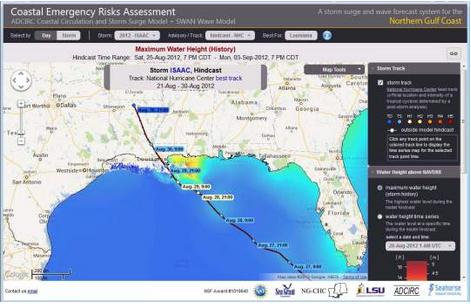
A Better Way To Estimate Hurricane Damage Than Saffir Simpson Scale?
Just looking at the wind intensity and category (1-5) may be too
simplistic; new research at LSU shows there may be a better way to model
and rate damage potential, especially from category 1 storms capable of
category 4-level damage. Here's an excerpt from Baton Rouge's
theadvocate.com: ...“
We no longer just want to focus on the
Saffir-Simpson scale,” Santos said. Instead, it’s becoming more
important to look at individual impacts that rain, storm surge, winds,
speed of the storm and more will have on particular areas, he said.
Information from a much more detailed storm surge model being run at
LSU, combined with disaster impact information from the Stephenson
Disaster Management Institute at LSU, will help provide much better
risk specifics with each storm, Santos said..."
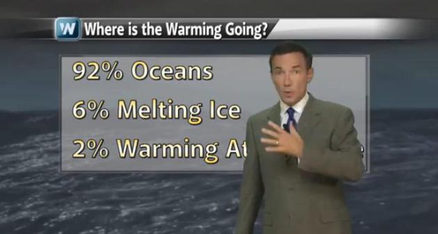
Live Local - Think Global. It was a chilly May (and
spring) across the Upper Midwest and a fairly sizable chunk of the
USA, in fact spring was the first cooler-than-average season in nearly
3 years over the Lower 48 states. But that doesn't mean the rest of
the world is feeling unusual chill. May was tied for 3rd warmest
worldwide, spring was the 8th warmest (land and ocean water
temperatures) globally, according to NOAA NCDC. In other words, don't
look out your window and assume the weather you're experiencing is
what's happening (everywhere else). Details in today's edition of
Climate Matters: "
The
spring of 2013 was colder than average for many across the U.S. But
that was not the story across other parts of the globe.
WeatherNation Chief Meteorologist Paul Douglas looks at the big
weather picture."
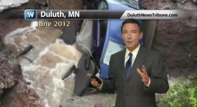
Historic Floods On The Increase. No kidding, Paul.
Increasingly, when it rains, it pours...and floods. North Dakota,
Minnesota, Wisconsin, Illinois and Michigan each had a top 10 wet
spring season in 2013. Iowa had its wettest spring on record with
17.61 inches of precipitation. Friday evening's amazing downpour was
a reminder of just how fast the water can come down now.
Meteorologist Paul Douglas looks at what may be fueling the heavy
downpours in today's edition of
Climate Matters. Duluth 2012 Flooding video provided by the Duluth News Tribune. Click here for more of their coverage:
http://www.duluthnewstribune.com/even...
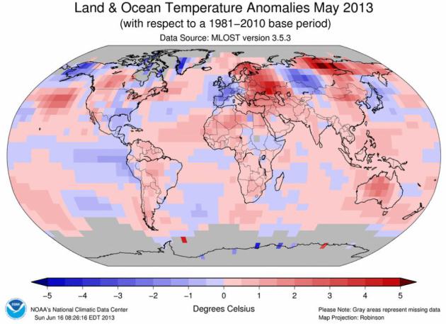
May: Third Warmest On Record, Worldwide. Here's an
excerpt of a comprehensive global summary of May, which was chilly
over Minnesota and parts of Europe. The rest of the planet? Not so
much. Details from
NOAA NCDC:
- The combined average temperature over global land
and ocean surfaces for May 2013 tied with 1998 and 2005 as the third
warmest on record, at 0.66°C (1.19°F) above the 20th century average of 14.8°C (58.6°F).
- The global land surface temperature was 1.11°C (2.00°F) above the 20th
century average of 11.1°C (52.0°F), also the third warmest May on
record. For the ocean, the May global sea surface temperature was
0.49°C (0.88°F) above the 20th century average of 16.3°C (61.3°F), tying with 2003 and 2009 as the fifth warmest May on record.
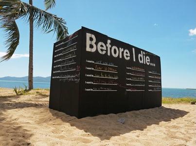
Watch: What Do YOU Want To Do Before You Die. A
morbid topic? Maybe, definitely not something we tend to chat about with
friends or family members, and yet maybe this is a conversation we
should have, at least with ourselves. Here's an excerpt of a post (and
great video) from Candy Cang at
Huffington Post: "...
Contemplating
death, as Stoics and other philosophers encourage, is a powerful
tool to re-appreciate the present and remember what makes your life
meaningful to you. We're all trying to make sense of our lives and
there's great comfort in knowing you're not alone. Everyone you're
standing with in line and everyone you're sitting by in a cafe and
everyone you walk past on the street is going through challenges in
their life. Yet it's easy to forget this because we rarely venture
beyond small talk with strangers. There are a lot of barriers to
opening up..."
Photo credit above: Townsville, Australia. Credit: Kim Kamo.
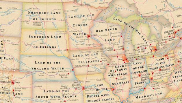
Land Of The Cloudy Water. That's the literal
translation of "Minnesota", so why don't we call it that? Waterfall City
sounds better than Stink Onion (Chicago) or Sibling Love
(Philadelphia). Good grief. Here's an excerpt of an eye-opening nugget
from
Slate: "
It’s
easy to think of words such as California or Texas or New York as
just the places on the map, but those words actually meant something,
once, and those meanings offer a little glimpse into history. The
above map, designed by cartographers Stephan Hormes and Silke Peust,
labels states, cities, and landmarks with the literal meanings of
their official names. Most of the meanings are bland descriptions of
the terrain or climate of the places they describe. Michigan, for
example, is the “Land of the Big Lakes” (duh), and Mississippi is the
“Land of the Great River.” Others carry baffling specificity, like
Alabama’s “Land of the Thicket Clearers” or Missouri’s “Land of the
People with Dugout Canoes....”
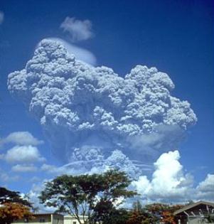
Summer Solstice Frost of 1992. I had forgotten about
this freakish weather event on June 21, 1992 - linked to the Mt.
Pinatubo volcanic eruption, which had a temporary cooling effect
worldwide. Dr. Mark Seeley has more details in this week's edition of
WeatherTalk; here's an excerpt: "
This
date is a memorable one in Minnesota history as the only summer
solstice that brought damage frost to the state's corn and soybean
crops. The Mt Pinatubo eruption in the Philippines during 1991 was
later attributed to be one of the causes of this event which turned out
to a singularity in Minnesota's climate history. Temperatures as
cold as 25 degrees F (Brimson) were reported in the north, but even
as far south as Preston, Theilman and Zumbrota reported 33 degrees F
with frost in low spots. Some corn fields were severely damaged and
later only harvested for silage. Soybeans leaves mostly burned by
the frost recovered and produced even pods and beans for harvest, but
the yields were not very good..." (image of Mt. Pinatubo courtesy of Wikipedia).
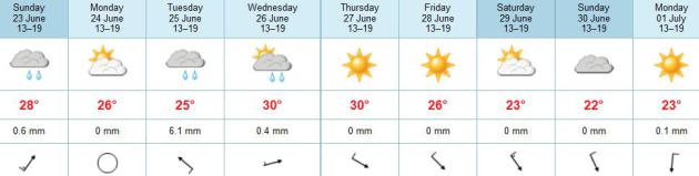
TODAY: Morning T-storms, flash
flood potential. Sticky start - sunnier and drier late in the day.
Winds: SW 10-15. Dew point: 71. High: 84
SUNDAY NIGHT: Partial clearing. Low: 66
MONDAY: More sun, probably dry. Dew point: 65. High: 86
TUESDAY: Unsettled, few T-storms. Dew point: 72. Wake-up: 68. High: 85
WEDNESDAY: Partly sunny, stray T-storm. Wake-up: 72. High: 89
THURSDAY: Hot sun. Dew point: 68. Wake-up: 71. High: near 90
FRIDAY: Plenty of sun, less humid. Dew point: 58. Wake-up: 65. High: 84
SATURDAY: Lot's of sun, more comfortable. Wake-up: 63. High: 79
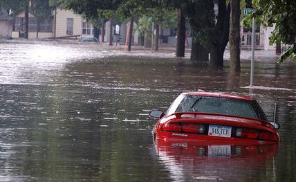
Photo credit above: "
A few onlookers were out early
Saturday morning but the cleanup effort had yet to begin at E. 35th St.
near 15th Avenue S., across from Powderhorn Park where this car was
crushed by a toppled tree in Friday's storm and seen Saturday, June 22,
2013, in Minneapolis, MN." (DAVID JOLES/STARTRIBUNE)
Climate Stories...
Climate Change Means We'll Be Living In A Very Wet World.
Wet areas will get wetter, but dry regions of the planet are forecast
to get even hotter and drier. All or nothing in the moisture department.
Did you know that Mayor Bloomberg just pitched at $20 billion plan to
protect New York City, including 20 foot high seawalls? Here's an
excerpt from a story at
care2.com: "...
Engineers
have been at work creating floodgates and other technologies and
infrastructure to help cities like New York in the event of major
flooding. New York City’s mayor, Michael Bloomberg, recently unveiled a $19.5 billion plan
to prepare the city for the effects of climate change; six-meter-high
(20-foot) waterfront walls and dikes are to be constructed to prevent
flooding. But should municipalities allow building in places – coastal
shorelines, barrier islands — that are likely to be hit hard by
hurricanes and tropical storms? Should property owners assume more of
the risk if they choose to build and/live in high-risk areas? Should more power and utility lines be installed underground?
In a climate changed world, what once passed for “record flooding”
could become routine and have a huge impact on more and more communities
as the population grows, especially in coastal areas and along rivers.
The FEMA report
does not itself make any recommendations for specific changes or
policies but it is harsh reminder that climate change is costly in more
than one sense of the word..."
4 Hiroshima Bombs Worth of Heat Every Second? That's a statistic that makes anyone with a pulse do a double-take. Here's an excerpt from Technology News and
TVNZ: "
The
planet has been building up temperatures at the rate of four Hiroshima
bombs of heat every second, and it's all our fault, say climate
scientists. Hurricane Katrina and superstorm Sandy are just two examples
of how extreme weather will intensify, Australia's Climate Action
Summit has heard. Humans are emitting more carbon dioxide into the
atmosphere than any other time in history, says John Cook, Climate
Communication Fellow from the Global Change Institute at the University
of Queensland. "All these heat-trapping greenhouse gases in our
atmosphere mean ... our planet has been building up heat at the rate of
about four Hiroshima bombs every second - consider that going
continuously for several decades..." (photo credit
here).
In Tuesday Speech, Obama To Unveil Plan To Cut Carbon Pollution 17% By 2020. The full story is at
Think Progress; here's an exerpt from a recent President Obama video teeing up next Tuesday's speech on climate change:
"This is a serious challenge – but it’s one uniquely suited to America’s strengths.
We’ll need scientists to design new fuels, and farmers to grow them.
We’ll need engineers to devise new sources of energy, and businesses to make and sell them.
We’ll need workers to build the foundation for a clean energy economy.
And we’ll need all of us, as citizens, to do our part to preserve
God’s creation for future generations – our forests and waterways, our
croplands and snowcapped peaks.
There’s no single step that can reverse the effects of climate
change. But when it comes to the world we leave our children, we owe it
to them to do what we can.
So I hope you’ll share this message with your friends. Because
this a challenge that affects everyone – and we all have a stake in
solving it together.
I hope to see you Tuesday. Thank you."
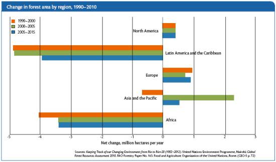
Climate Change "Will Increasingly Affect Businesses". Here's the intro to a story from
Environmental Management & Energy News: "
Extreme
weather events, water scarcity, biodiversity loss and other global
warming-related changes in the environment will increasingly affect
businesses and how they operate, according to a report released by the
United Nations Environment Programme. The report, GEO-5 for Business: Impacts of a Changing Environment on the Corporate Sector,
says the private sector’s operating costs, markets for products and
availability of raw materials will be affected by climate change.
Businesses that adapt by developing goods and services that can reduce
the impacts of climate change,
water scarcity and emissions as well as seize the demand for
sustainable technologies, investments and services will be successful,
the report says..."
Obama To Tap Executive Powers To Curb Emissions Blamed For Global Warming. Here's the intro to a story from AP and
The Washington Post: "
President
Barack Obama is planning a major push using executive powers to
tackle the pollution blamed for global warming in an effort to make
good on promises he made at the start of his second term. “We know
we have to do more — and we will do more,” Obama said Wednesday in
Berlin. Obama’s senior energy and climate adviser, Heather Zichal,
said the plan would boost energy efficiency of appliances and
buildings, expand renewable energy and use the Environmental
Protection Agency’s authority under the Clean Air Act to regulate
heat-trapping pollution from coal-fired power plants..."
Photo credit above:
Pablo Martinez Monsivais/Associated Press. "President
Barack Obama speaks in front of the iconic Brandenburg Gate in
Berlin Germany, Wednesday, June 19, 2013. Obama is planning a major
push using executive powers to tackle the pollution blamed for
global warming in an effort to make good on promises he made at the
start of his second term. “We know we have to do more — and we
will do more,” Obama said in Berlin."


No comments:
Post a Comment