79 F. high in the cities Friday.
79 F. average high.
70 F. high June 14, 2012.
.01" rain fell yesterday.
Few T-storms possible by mid afternoon in the metro.
Drier weather expected Sunday.
Bright Gray
The weather forecast is rarely black or white.
It's usually some cruel shade of gray. Your home is right on the
rain-snow line; you're on the edge of the rain or precariously close to
the front.
We sometimes give a probability of
precipitation, but this can be confusing. A 30 percent chance of showers
doesn't mean rain over 30 percent of the area, or rain 30 percent of
the time. It means that on 3 out of 10 days one location will see a
trace of rain.
Huh?
This weekend will be better than last, although
that's a pretty low bar. A frontal passage fires off a few T-storms,
mainly southern MN. The best chance of puddles: south of MSP, especially
morning and midday. A northwest breeze should begin to clear skies by
afternoon, especially central and northern lakes.
Sunday still looks like the sunnier, warmer day
statewide, with some low 80s. June, the way it was probably meant to be
at this latitude.
Dry weather prevails the first half of next week; more storms possible by Thursday, again a week from today. Of course!
A southerly dip in the jet stream has meant more
frequent changes, only 24-36 hours of dry weather between fronts or
storms. It's almost as if Mother Nature has picked up her remote control
and put our weather on fast-forward!
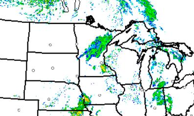
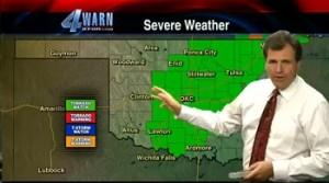
Not Out Of The Woods Just Yet.
NOAA's high-res HRRR model shows a few clusters of showers and T-storms
popping this afternoon. The map above is valid 3 pm this afternoon. Most
of today will be dry, but watch for an hour or two of rain this
afternoon, with the best chance of T-storms from the metro on south and
east.
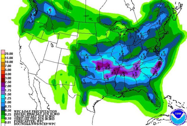
Drying Out A Bit. The epicenter
of wetness shifts into the Middle Mississippi valley and Mid South in
the coming days, as well as the Pacific Northwest. The pattern appears
slightly drier for the Upper Midwest and Great Lakes. QPF map courtesy
of NOAA.
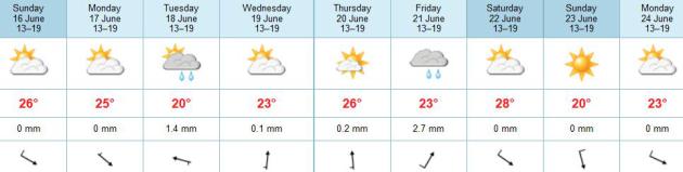
Limping Into Summer. Low 80s
will feel good today and Sunday; a few T-storms Sunday night marking the
leading edge of slightly cooler air early next week. A few 80s return
by the end of next week (along with more humidity and scattered
T-storms), but no scorching heat is in sight. ECMWF model highs above in
Celsius. As if you couldn't figure that out.
From Too Dry To Too Wet - Some Farmers Are Not Happy. Here's an excerpt from this week's edition of Mark Seeley's
WeatherTalk Newsletter: "...
The
rainfall and wet soils have resulted in prevented planting for some
corn fields, where producers will be able to collect crop insurance
payments if they don't plant corn. Others may opt to plant corn, but
not for grain, just for silage to feed livestock. Some soybeans are
still being planted late, along with some late planting of alfalfa
fields which were so adversely affected by winter stress. Alfalfa hay
cutting has progressed very slowly with little of the hay harvest
completed..."
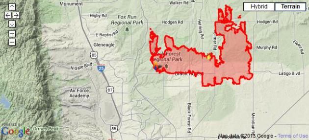
Colorado's Most Destructive Wildfire. The Black Forest fire is only 30% contained, at last report. Here's the latest from
inciweb.org:
"The Black Forest Fire started on Tuesday, June 11. The cause is
undertermined. It is located in the northeast section of Colorado
Springs, within the city limits. Rich Harvey's Great Basin Type 1
Incident Management Team took over management of the fire on Wednesday
at 6 a.m.
This wind driven fire moved very quickly the first day and destroyed
aproximately 360 structures and also caused the immediate evacuation
of several thousand residents. Assessment of structures is ongoing and
will be updated when additional information is available. There are
numerous interagency resources assigned to the fire with others
arriving daily.
Basic Information
| Incident Type |
Wildfire |
| Cause |
Under Investigation |
| Date of Origin |
Tuesday June 11th, 2013 approx. 02:30 PM |
| Location |
Within the City limits of Black Forest Colorado |
| Incident Commander |
Rich Harvey |
Current Situation
| Total Personnel |
1,060 |
| Size |
15,500 acres |
| Percent Contained |
30% |
| Estimated Containment Date |
Thursday June 20th, 2013 approx. 12:00 AM |
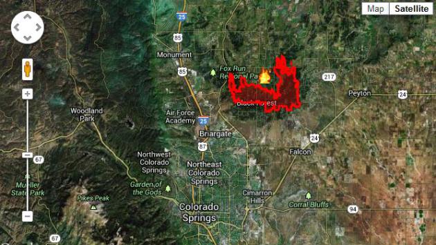
Interactive Wildfires Map Tracks The Blaze In Colorado. Here's another good resource from
Climate Central: "
Aided by strong winds, the wildfire south of Denver has now become the most destructive fire in Colorado's history, surpassing 2012's Waldo Canyon fire.
It's burning through thousands of acres of land, and firefighters are
struggling to contain the blaze. The 15,000 acre Black Forest fire has
destroyed at least 360 homes and forced the evacuation of nearly 40,000
people from areas in and near Colorado Springs, the state's
second-largest city. The Black Forest fire is one of three wildfires
currently burning across Colorado.You can monitor the wildfires with
Climate Central’s interactive wildfires map. The flame icons represent
wildfires currently active in the lower 48 states and Alaska, including
the Black Forest fire in Colorado. Hover over a given fire to see its
name, and if you zoom in you’ll be able to see the outline of the area
that’s burning — the so-called fire perimeter. If you click within the
perimeter, a window pops up showing the fire’s size in acres, the
amount by which the perimeter has grown or shrunk over the past 24
hours, the fraction of the fire that has been contained and other data.
There’s also a link to an even more detailed report..."
* The PBS NewsHour has more on Colorado's most destructive wildfire in it's history
here.
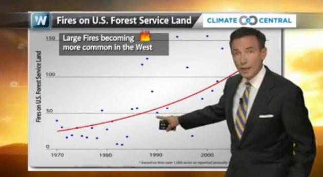
An Early Start To Wildfire Season. In today's edition of "
Climate Matters"
we examine wildfire trends over the western USA. Wildfire season is now
an average of 78 days longer than it was in 1970. Dry areas are
becoming even drier, and when winter snows are lighter than average it
can set the stage for a long, hot, fiery season. Such will be the case
in 2013.
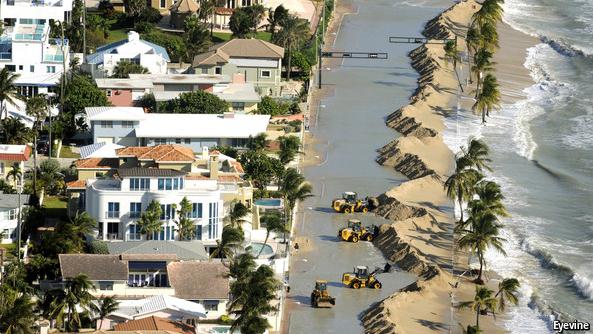
You're Going To Get Wet.
The Economist
reports that Americans are building beachfront homes, even as ocean
levels continue to rise. What's the definition of insanity? Doing the
same thing over and over again, expecting different results? Better to
buy a home 5 blocks inland...and be patient. Here's an excerpt: "
Before
Hurricane Sandy tore through New York and New Jersey, it stopped in
Florida. Huge waves covered beaches, swept over Fort Lauderdale’s
concrete sea wall and spilled onto A1A, Florida’s coastal highway. A
month later another series of violent storms hit south Florida,
severely eroding Fort Lauderdale’s beaches and a chunk of A1A. Workers
are building a new sea wall, mending the highway and adding a couple of
pedestrian bridges. Beach erosion forced Fort Lauderdale to buy sand
from an inland mine in central Florida; the mine’s soft, white sand
stands out against the darker, grittier native variety. Hurricanes and
storms are nothing new for Florida. But as the oceans warm, hurricanes
are growing more intense. To make matters worse, this is happening
against a backdrop of sharply rising sea levels, turning what has been a
seasonal annoyance into an existential threat..."
Photo credit: Eyevine.
Survivors Blame KFOR Meteorologist For Tornado Deaths.
I know Mike Morgan down in Oklahoma City; he's a friend and a gifted
meteorologist. I'm sorry he's at the center of controversy over comments
he made before the El Reno EF5 tornado spun up, recommending that
people without basements, in the direct path of the tornado, consider
getting into their vehicles. The result was gridlock, massive traffic
jams, and many people think it was the wrong message to send to the
public. It's a really tough call when you have an extreme tornado moving
in, and less than 1 in 10 viewers have basements. Statistically your
odds are still better staying home, riding out the tornado in a closet
or bathtub, than getting into your vehicle (or a nearby drainage ditch
or storm sewer, which may quickly overflow as a tornadic storm passes
overhead). That's apparently what happened on May 31 in El Reno. Here's
an excerpt from
TVSpy: "
The Oklahoman has published a story that suggests KFOR
meteorologist Mike Morgan was to blame for the deaths of five Oklahoma
City family members after they followed his advice about escaping an
oncoming tornado. Virginia Shrum said her brother talked about how he
had hidden down in the tunnel from a tornado three years before. The
survivors said they were swayed to flee the apartment by warnings from
Mike Morgan, KFOR-TV chief meteorologist. The article said 11 people hid
in a long drainage tunnel behind the family’s apartment to escape the
oncoming twister. They were swept from the tunnel by a flash flood..."
* the story at The Oklahoman is
here.
. Having just been thru the Panama Canal last winter, I found this article at
Quartz fascinating - is there really room for two transoceanic canals? Here's a clip: "
Today, Nicaragua’s parliament is expected to approve proposals by a Chinese consortium to build a canal across the country to rival that of Panama. (Update: The plan has been approved.) The
$40 billion project could double Nicaragua’s GDP and create 40,000
construction jobs over an 11-year construction period. The idea of
building a canal in Nicaragua is nothing new. For most of the 19th
century, experts considered a Nicaraguan canal more feasible than one through Panama or
another proposed route through Mexico. US tycoon Cornelius Vanderbilt
led a project to carry goods across Nicaragua by stagecoach and
steamship as a prelude to building a canal, for which he even won a
concession. Thirty years later, US president Ulysses S. Grant endorsed
the Nicaraguan route as the cheapest and easiest, pegging the cost (p.110-111) at
$52,577,718.00—though he admitted that, with probable delays, it could
stretch to $100 million. A Nicaraguan canal would be more
cost-effective than a Panama one, he argued, where builders would
encounter tougher terrain..."
Photo credit above: "
Even after Panama's canal expansion is complete, Nicaragua's would be bigger." AP Photo/Arnulfo Franco
TODAY: Patchy clouds early, then partly sunny and warm with an afternoon T-storm. Winds: W 5-10. High: 81
SATURDAY NIGHT: Partly cloudy. Low: 62
FATHER'S DAY: Sunnier, drier and warmer - a better day for the lake. High: 83
MONDAY: More clouds than sun, cooler. Wake-up: 64. High: 76
TUESDAY: Partly sunny, pleasantly mild. Wake-up: 58. High: 77
WEDNESDAY: Mix of clouds and sun, warmer. Wake-up: 62. High: 80
THURSDAY: Sticky, a few T-storms nearby. Wake-up: 64. High: 79
FRIDAY: Patchy clouds, warm and muggy with a few T-storms possible. Wake-up: 68. High: 83
Climate Stories....
How Climate Change Makes Wildfires Worse.
Mother Jones has the story - here's an excerpt: "...
Big
wildfires like Colorado's thrive in dry air, low humidity, and high
winds; climate change is going to make those conditions more frequent
over the next century. We know because it's already happening: A University of Arizona report
from 2006 found that large forest fires have occurred more often in
the western United States since the mid-1980s as spring temperatures
increased, snow melted earlier, and summers got hotter, leaving more and
drier fuels for fires to devour. Thomas Tidwell, the head of the
United States Forest Service, told a Senate committee
on energy and natural resources recently that the fire season now
lasts two months longer and destroys twice as much land as it did four
decades ago. Fires now, he said,
burn the same amount of land faster. We can expect "as much as a
fourfold increase in parts of the Sierra Nevada and California" in fire
activity across the rest of this century, says Matthew Hurteau,
assistant professor of ecosystem science and management at Pennsylvania
State University..."
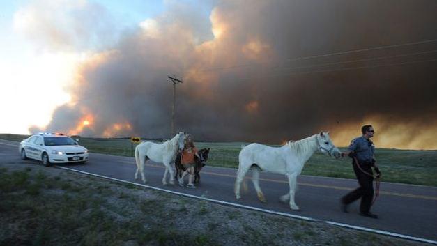
Photo credit above: "
El Paso County Sheriff's Deputy Dan Cukowski helps evacuate Linda Davies and her horses during the Black Forest Fire on June 11." Jerilee Bennett/MCT/ZUMAPRESS
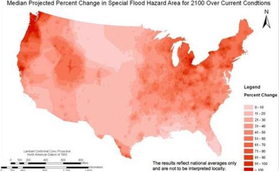
Climate Change Could Increase Areas At Risk Of Flooding By 45 Percent. Here's the intro to a story at
The Atlantic Cities: "
Rising
seas and increasingly severe weather are expected to increase the
areas of the U.S. at risk of floods by up to 45 percent by 2100,
according to a first-of-its-kind report released by the Federal Emergency Management Agency on Wednesday.
These changes could double the number of flood-prone properties
covered by the National Flood Insurance Program and drastically
increase the costs of floods, the report finds. The report concludes
that climate change is likely to expand vastly the size and costs of
the 45-year-old government flood insurance program. Like previous
government reports, it anticipates that sea levels will rise an average of four feet
by the end of the century. But this is what's new: The portion of the
US at risk for flooding, including coastal regions and areas along
rivers, will grow between 40 and 45 percent by the end of the century.
That shift will hammer the flood insurance program. Premiums paid into
the program totaled $3.2 billion in 2009, but that figure could grow to
$5.4 billion by 2040 and up to $11.2 billion by the year 2100, the
report found. The 257-page study has been in the works for nearly five
years and was finally released by FEMA after multiple inquiries from
Climate Desk and Mother Jones..." (photo credit: Reuters).
Map: Places That Will Flood More Often Due To Global Warming.
Slate has the story - here's an excerpt: "...
The
FEMA study is based on the assumption that sea levels will go up by 4
feet in the next 86 years. But a report released last year by the
National Oceanic and Atmospheric Administration noted that sea level
rise could be more than 6 feet.
Whether it's 4 feet or 6 feet, rising seas cause shoreline erosion and
recession, and create greater surge risk in the event of major storms.
The FEMA report also notes that flooding around rivers will likely
become worse in a warming world, due to changes in precipitation
frequency and intensity. Population growth, which causes increases in
paved areas and changes in runoff patterns and drainage systems, will
affect the amount of flooding from rivers..."
* the PDF report referenced above is
here.
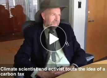
Jim Hansen: Climate Change Is The GOP's Worst Nightmare. Here's a snippet from an interview at The Denver Post: "Many conservative politicians have been among climate change
deniers, but ignoring the science will led to something the GOP dreads
even more — big government. So argued Jim Hansen, who since 1988 has
been in the forefront of the issue, first as a NASA scientist and more
recently as a free-agent activist, in an interview Thursday..."
How EPA Fights Climate Change Even When Congress Doesn't Want It To.
Yahoo! News has the story; here's a clip: "
Environmental groups have a tough time getting Congress
to do what they want. Case in point: In the early months of 2010, the
Sierra Club, the Natural Resources Defense Council, and the Environmental Defense Fund waged an all-out campaign urging the Senate to pass a sweeping climate-change bill backed by President Obama
and leaders in the Democratic-controlled Senate. The measure crashed
and burned that summer. But the green groups—and Obama’s top
environmental officials—knew they could resort to a different tactic:
lawsuits to compel executive action..."
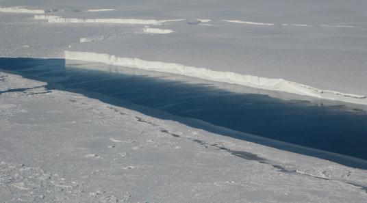
Warm Ocean Causing Most Antarctic Ice Shelf Mass Loss.
NASA has the details; here's an excerpt: "
Ocean
waters melting the undersides of Antarctic ice shelves are
responsible for most of the continent's ice shelf mass loss, a new
study by NASA and university researchers has found. Scientists have
studied the rates of basal melt, or the melting of the ice shelves
from underneath, of individual ice shelves, the floating extensions of
glaciers that empty into the sea. But this is the first comprehensive
survey of all Antarctic ice shelves. The study found basal melt
accounted for 55 percent of all Antarctic ice shelf mass loss from
2003 to 2008, an amount much higher than previously thought. Antarctica
holds about 60 percent of the planet's fresh water locked into its
massive ice sheet. Ice shelves buttress the glaciers behind them,
modulating the speed at which these rivers of ice flow into the ocean.
Determining how ice shelves melt will help scientists improve
projections of how the Antarctic ice sheet will respond to a warming
ocean and contribute to sea level rise. It also will improve global
models of ocean circulation by providing a better estimate of the
amount of fresh water ice shelf melting adds to Antarctic coastal
waters..."
Photo credit above: "
This photo shows the ice front of Venable Ice Shelf, West Antarctica, in October 2008." Image credit: NASA/JPL-Caltech/UC Irvine
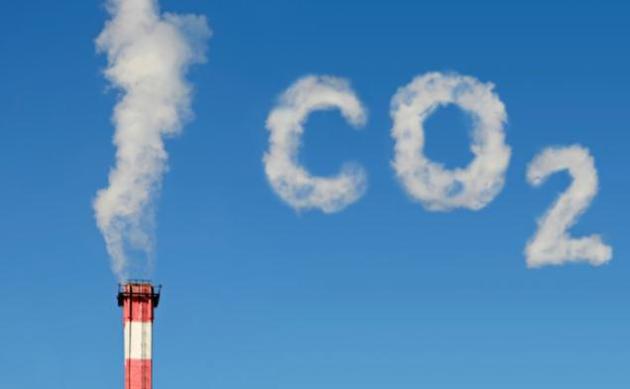
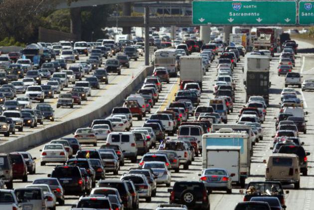
Obama Quietly Raises Carbon Price As Costs To Climate Increase. Bloomberg.com
has the story - here's an excerpt: "Buried in a little-noticed rule on
microwave ovens is a change in the U.S. government’s accounting for
carbon emissions
that could have wide-ranging implications for everything from power
plants to the Keystone XL pipeline. The increase of the so-called
social cost of carbon, to $38 a metric ton in 2015 from $23.80, adjusts
the calculation the government uses to weigh costs and benefits of
proposed regulations. The figure is meant to approximate losses from
global warming such as flood damage and diminished crops.
Photo credit above: "
For example, the administration’s
vehicle fuel-efficiency standards would cost industry $350 billion over
the next 40 years, while benefits in energy security, less congestion
and lower pollution totaled $278 billion." Photographer: Reed Saxon/AP Photo.

No comments:
Post a Comment