84 F. high on Sunday in the Twin Cities.
81 F. average high on June 23.
78 F. high on June 23, 2012.
.26" rain fell at KMSP yesterday.
15 hours, 26 minutes of daylight today. 1 minute less than yesterday.
8 hours, 46 minutes of daylight on December 21 in the Twin Cities.
Severe Perspective
Lessons from the Friday evening record bow echo
(above) that whipped up 60-80 mph winds for 15 long minutes? Trees are
going to come down with increasing frequency. A little strategic pruning
may lower the risk of one landing on your home or car.
And don't dismiss Severe Storm Warnings. Yes,
they're a dime a dozen - far more likely to be ignored than a Tornado
Warning. But here's the thing: Friday's severe straight-line winds
created a damage swath consistent with a 15 mile wide EF-0 to EF-1
tornado. It doesn't have to be a tornado to wreak havoc. One
minor miracle: biggest power outage in Minnesota history, yet no
storm-related fatalities or significant injuries, that I'm aware of.
It's amazing (to me) that all those trees coming down didn't hit people.
Something to be very grateful for.
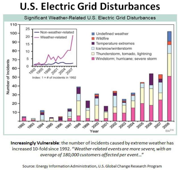
But it's becoming increasingly obvious that
infrastructure built in the 19th & 20th century is going to have a
rough time weathering 21st century severe local storms. According to the
Energy Information Administration the number of outages on the U.S.
electrical grid has increased ten-fold since 1992, mostly the result of
high winds. Ten-fold. But I'm sure that's just another head-scratching
coincidence.
We should hit 90F today & Tuesday with more
severe storms; best chance late each day. A dry pattern returns Thursday
into the weekend. Blue sky, highs near 80, dew points in the 50s next
weekend?
Dear Diary, you're not going to believe this. I'm optimistic for the 4th of July too.
* frame-grab up top from RadarScope app showing Friday's evening's bow echo courtesy of WeatherNation meteorologist Todd Nelson. When you see an approaching thunderstorm blob that looks like a horse-shoe, bulging into a spear-like point as it accelerates forward, it's time to head for the basement. Potentially damaging winds are imminent.
Severe Risk. A
little perspective is in order as we recover from Friday's traumatic
severe windstorm. June is the wettest month of the year; it's also the
most severe month of the year, on average. June is a rough month to
begin with, made harder this year by a jet stream blowing close to
Minnesota. Some of that high-velocity air worked its way to the ground
in Friday evening's severe thunderstorm.
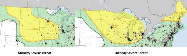
Ripe For More Storms.
The next surge of hot, steamy air sets up an episode of strong to
severe T-storms from Monday evening into Wedneday across the Upper
Midwest and Great Lakes, reaching northern New England by midweek.
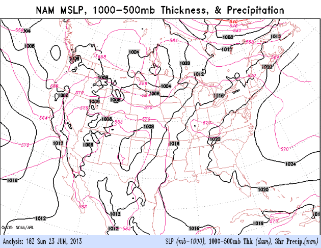
Showery rains continue from the San Francisco Bay area into the Pacific
Northwest - the tropics remain quiet looking out at least 7-10 days. 84
hour NAM model: NOAA.
Pushing Into A (Slightly) Drier Pattern.
T-storms will be with us tonight into Wednesday, but we finally dry out
the latter half of this week; odds favor dry (beautiful) weather on
Saturday, only a few spotty T-storms up north next Sunday. Highs may
approach 90 today and Tuesday, again Thursday, before cooling off
slightly by the weekend.
Ball Lightning From Sunday Morning's Storms? Here's
a portion of an e-mail I received from Dean DeHarpporte, a consulting
meteorologist based in Eden Prairie. I'm impressed, and as I told Dean,
more than a little jealous. I have yet to see ball lightning (or the
"green flash" at sunset, for that matter). Here is what he wrote: "Paul,
my wife an I witnessed an apparent display of ball lightning between 330
AM and 430 AM this morning. Although we are taught very little about ball
lightning as meteorologists, I have always
considered ball lightning to be basketball-size and lasting for
several minutes. Large, long-lasting instance of ball lightning have exploded
and caused fatalities. However, the phenomena has been reported in
many sizes and durations.
The
phenomena we observed within the grove of trees out our large 2nd story bedroom
window were approximately 25 points of bright white light lasting
about one-two seconds before blinking out. The distance ranged from as close as
~20 feet to as distant as ~120 feet outside our window. The height ranged from
5-15 ft above ground. I estimate the intensity (very roughly) as that of a
200 watt incandescent bulb. The light bursts were bright enough to remain
visible even as dawn approached. Light rain fell intermittently and we heard
occasional rumbles of thunder originating miles away.
According
to the Wickipedia article http://en.wikipedia.org/wiki/Ball_lightning (which is
extremely interesting) ball lightning is "unexplained". A review
of the available literature published in 1972 identified the properties of a “typical” ball
lightning, whilst cautioning against over-reliance on eye-witness accounts:
- They frequently appear almost simultaneously with cloud-to-ground lightning discharge
- They are generally spherical or pear-shaped with fuzzy edges
- Their diameters range from 1–100 cm, most commonly 10–20 cm
- Their brightness corresponds to roughly that of a domestic lamp, so they can be seen clearly in daylight.

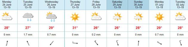
TODAY: Hot sun. Probably dry thru the dinner hour. Winds: SE: 10. Dew point: 67. High: near 90
MONDAY NIGHT: T-storms likely, a few may be severe. Locally heavy rain and flash flooding possible. Low: 70
TUESDAY: Sticky. Few severe storms. Dew point: 73. High: 90
WEDNESDAY: Widespread storms, some strong. Wake-up: 73. High: 88
THURSDAY: Hot sun; a drier day. Dew point: 64. Wake-up: 72. High: 88-90.
FRIDAY: Partly sunny, less humid. Dew point: 60. Wake-up: 68. High: 85
SATURDAY: Blue sky, comfortable. Dew point: 57. Wake-up: 66. High: 80
SUNDAY: Fading sun, warm. Storms far north. Wake-up: 65. High: 82
Climate Stories....
- Minnesota climate scientist Greg Laden

No comments:
Post a Comment