89 F. high in the Twin Cities Wednesday.
82 F. average high on June 26.
82 F. high on June 26, 2012.
Trace of rain fell at MSP International Airport yesterday.
Dew points drop into the mid 60s today, 50s tomorrow and Saturday.
Don't Push the Weather
Linnaea Nelson writes "We read you religiously
every morning. I am in my 70’s and have just joined the smartphone
crowd. Which weather-warning app would be the best to download on my
iPhone5?" Thanks for the nice note Linnaea. My personal favorites are
RadarScope, My-Cast Weather Radar, Victory Rides and WeatherRadio. You'll get up to the
second Doppler info, maps and warnings for your location, 24/7. And no,
I don't get a commission.
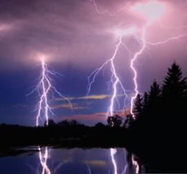
With My-Cast you can get lightning alerts, which
come in very handy. According to NOAA 238 people were killed by
lightning from 2006 to 2012, 82 percent of them male. Fishing topped the
list, followed by camping, boating, soccer & golf.
As I tell my Naval aviator son: don't push the weather.
Precipitation for 2013 is running 7.3 inches
wetter than average to date, but we seem to be transitioning into a
drier pattern. A twist of chilly air aloft may spark a late-day T-shower
up north Friday - with clouds and a stray shower Saturday; a fairly
cool day. Sunday looks sunnier and milder.
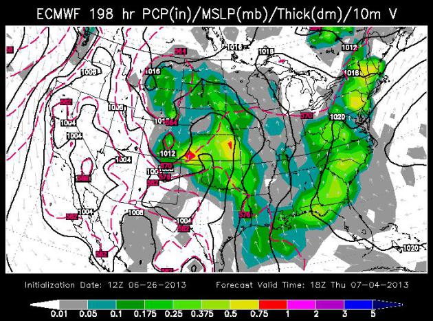
All well and good, but what about the 4th? I
defer to the European model, which shows 70s and a growing chance of
scattered showers and T-storms next Thursday PM into Friday as a storm
pushes north across the Plains. I really hope the ECMWF is wrong. I'm
lighting a candle, saying a prayer & hoping for the best.
Photo credit above: Brad Birkholz. Screen shot of lightning loop upper right from My-Cast Weather Radar.
Not As Optimistic For The 4th.
An instability shower is possible late Friday into Saturday; Sunday
still the sunnier, nicer day of the weekend, with a lovely first half of
next week. Which would be great if we celebrated the 4th of July on
July 2. The chance of showers and T-storms increases Thursday PM into
Friday, with a chance of some partial clearing by next weekend. It's
just to early to say with any level of confidence, and with our wonky
weather pattern (stuck in a rut) all bets are off.
The Source of Holiday Angst.
Hey, it's still a week away; maybe the models will become more
optimistic with time. Maybe I'll grow hair and become a rock and roll
singer. Doubtful, but one never knows. The map above is the "Euro" model
valid midday next Thursday, the 4th of July, showing the best chance of
showers and T-storms over far southwestern MInnesota, a broad Plains
storm pushing northeast, casting doubt on Thursday evening fireworks and
Friday activities. Map: WSI.
GFS Outlook for the 4th of July.
The U.S. GFS solution has a vaguely similar solution for next Thursday;
a much better chance of heavy showers and T-storms just south of
Minnesota. It's too early to panic, but have a Plan B (indoors) just in
case.
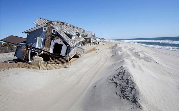
Surprise: New FEMA Maps Put More Of Edina In Flood Plain. Here's an excerpt from
The Star Tribune: "...
The
new FEMA maps are part of a national effort to update and improve
flood plain mapping, said Ceil Strauss, state flood plain coordinator
for the Department of Natural Resources. In Minnesota, she said, the
effect of the update, which calculates runoff from a 100-year flood,
varies by county. In Washington County, twice as many properties were
removed from flood zones as went in. But in other counties, flood
plains were added around lakes, affecting more property owners. In
Hennepin County, updated mapping provided more detail on elevation,
changing the boundaries of flood plains along Minnehaha and Nine Mile
creeks, Strauss said. “There are winners and losers there from the
perspective of homeowners,” she said..."
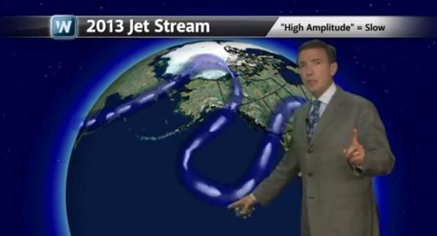
Uncharted Waters. As I explain in today's edition of
Climate Matters,
I've been tracking weather for close to 40 years, and I've never seen
anything like the last 3 years; the jet stream literally off the rails
since about 2010 (when Minnesota saw the most tornadoes in the USA).
Since then it's been one extreme after another, drought to flood to
drought, serious weather whiplash: "
The Jet Stream's normal West to
East flow has been replaced by a Jet Stream with giant atmospheric
wiggles. WeatherNation Chief Meteorologist Paul Douglas explains how
this impacts our day to day weather and leads to record heat in Alaska,
historic flooding in Calgary and destructive wildfires in Colorado and
the Southwest."
94F in Alaska? Weather Extremes Tied To Jet Stream.
When I tell people that the pattern has changed, that the jet stream
has become unrecognizable, I'm accused of hype (or worse). It turns out
I'm not the only one making these observations. Here's an excerpt of a
story at
AP News: "...
Consider these unusual occurrences over the past few years:
- The winter of 2011-12 seemed to disappear, with little snow
and record warmth in March. That was followed by the winter of 2012-13
when nor'easters seemed to queue up to strike the same coastal areas
repeatedly.
- Superstorm Sandy took an odd left turn in October from the
Atlantic straight into New Jersey, something that happens once every
700 years or so.
- One 12-month period had a record number of tornadoes. That was followed by 12 months that set a record for lack of tornadoes.
And here is what federal weather officials call a "spring
paradox": The U.S. had both an unusually large area of snow cover in
March and April and a near-record low area of snow cover in May. The
entire Northern Hemisphere had record snow coverage area in December
but the third lowest snow extent for May. "I've been doing meteorology
for 30 years and the jet stream the last three years has done stuff
I've never seen," said Jeff Masters, meteorology director at the
private service Weather Underground. "The fact that the jet stream is
unusual could be an indicator of something. I'm not saying we know what
it is." Rutgers' Francis is in the camp that thinks climate change is
probably playing a role in this..."
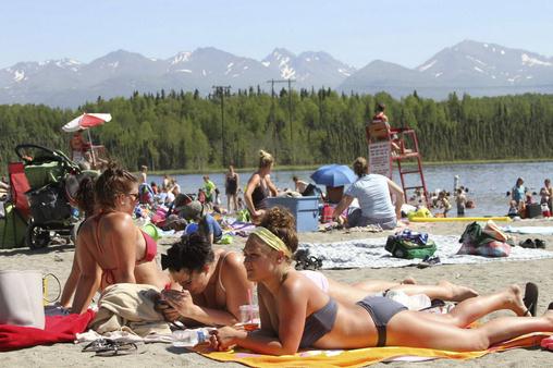
Photo credit above: "
This photo taken Monday, June 17,
2013, shows people sunning at Goose Lake in Anchorage, Alaska. Parts of
Alaska are setting high temperature records as a heat wave continues
across Alaska. Temperatures are nothing like what Phoenix or Las Vegas
gets, but temperatures in the 80s and 90s are hot for Alaska, where few
buildings have air conditioning." (AP Photo/Mark Thiessen)
Forecast for Death Valley/Furnace Creek:
Saturday: Sunny and hot with a high near 128.
Saturday night: Mostly clear, low around 98.
Sunday: Sunny and hot with a high near 129.
Sunday night: Mostly clear with a low around 101.
Monday: Sunny and hot with a high near 129.
* The USA high temperature record is 129F. We may set a new national record this weekend.
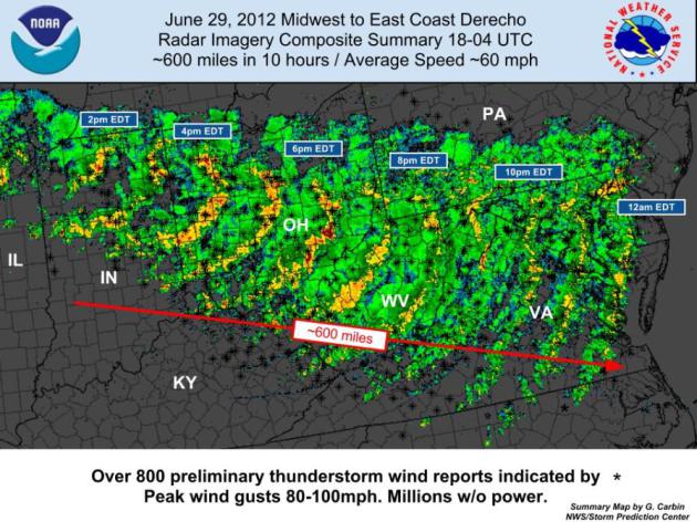
What Is A Derecho? Friday evening's severe wind
storm was triggered by a bow echo, powerful thunderstorm downdrafts
spreading out into violent straight-line winds at ground-level. A
derecho is an even larger phenomenon, a swirl of severe storms
traveling hundreds of miles over multiple states. Details in today's
edition of
Climate Matters: "
After
historic derechoes rolled through Chicago and Minneapolis/ St. Paul,
we turn our attention to an increasing threat that is usually
downplayed because "it's just a garden variety thunderstorm."
WeatherNationTV Chief Meteorologist Paul Douglas explains that these are
different than normal thunderstorms, exactly what a derecho is, as
well as what causes them."
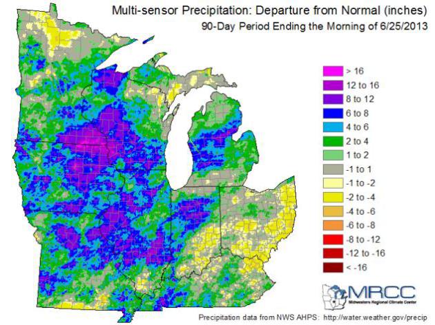
Not All Of The Corn Belt Is Wet. Check out the rainfall amounts over southeastern Minnesota in this post from
The Illinois Climatologist: "
Here
is the latest map of 90-day precipitation departures from average
across the Midwest. The greens, blues, and purple show areas that were 2
to 12 inches above average. That is the dominate feature of much of
the western and central Corn Belt. Meanwhile, the areas in light tan
and yellow in southeastern Indiana, southern and eastern Ohio, and
small patches in Kentucky and southern Illinois show areas that are 1
to 4 inches below average. The dry areas are nowhere near as severe as
2012. However, it is worth watching as we move through the growing
season." (map: Midwestern Regional Climate Center).
Fishing Tops List Of Lightning Death Activities.
Another good reason to have a few radar apps on your smart phone in the
boat, or a portable NOAA Weather Radio with you. Here's more from
Yahoo News: "
Most
lightning deaths in the United States occur while people are
enjoying outdoor activities, with fishing the most deadly, government
weather officials say. From 2006 to 2012, 238 people died after being
struck by lightning in the country — 82 percent of them male. Of the
total number of victims, 152 were taking part in leisure activities,
according to new findings from the National Weather Service .
Fishing topped the list with 26 lightning
deaths, followed by camping with 15 deaths, boating with 14, soccer
with 12 and golf with eight, NWS officials said. Other lightning
victims died while at the beach, swimming, walking, running or
picnicking. [Electric Earth: Stunning Images of Lightning]
Activities like fishing and camping may be most hazardous during a
storm because they often require extra time to take shelter in a safe
place, explained John Jensenius, a lightning safety specialist with
the NWS..." (photo image: discovery.com).
Cleaner Air Linked To More Hurricanes. Here's a snippet of an interesting story at
The Telegraph: "
Researchers
from the Met Office established a direct link between levels of
industrial pollution and the frequency of hurricanes in the North
Atlantic. For much of the 20th century, sooty pollution in the
atmosphere has made conditions unfavourable for the storms, causing
their numbers to drop. But since the 1980s, cleaner air over the
Atlantic has created better conditions for hurricane formation, with
more tropical storms developing and battering American and
Caribbean coasts as a result..."
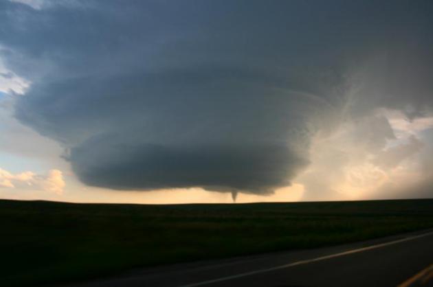
How Big Can A Tornado Actually Get On Earth? Good question: the (new) record is 2.6 miles wide, wind speeds around 300 mph. Here's an excerpt from
DVICE: ..."
We
don’t really know," tornado researcher Joshua Wurman of the Center
for Severe Weather Research told DVICE. "There are certainly extreme
limits; it’s unlikely you would get wind speeds greater than the speed
of sound, for instance. Whether they can even get close to that,
probably not. Nature is always trying to get rid of strong, anomalous
things. If there is an extremely strong wind, there are extremely
string dissipative forces seeking to get rid of that anomaly." By
mapping damage on either side of the storm’s path, weather spotters
determined the El Reno twister spanned 2.6 miles across as it raged
over 16.2 miles of ground west of Oklahoma City May 31. With surface
winds greater than 200 miles per hour, it was hardly the most
powerful tornado ever recorded, however. The record-holder, on May 3,
1999, reached wind speeds of 301 mph. That storm, incidentally, hit
Moore, Okla., recently devastated in a powerful tornado a week before
the El Reno storm. It’s possible that about 300 mph is just about as
powerful as tornadoes get, Wurman said. The 1999 storm caused $1
billion in damage..."
Photo credit:
National Severe Storms Laboratory
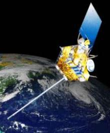
For Weather Satellites, Forecast Is Cloudy. Here's an update on the tenuous situation with America's weather satellites, courtesy of
news.gnom.es: "
As
hurricane season gathered force, the main U.S. weather satellite
watching the eastern seaboard failed last month for the second time in a
year. The difficulties with the seven-year-old weather satellite are
a symptom of a broader problem: Scientists are losing their orbital
eyes on Earth. Lee Hotz reports. Photo: AP. The main U.S. weather
satellite watching the eastern seaboard malfunctioned last month for
the second time in a year, underscoring the hazards of aging
satellites that monitor the planet as a threatening hurricane season
gets under way..."
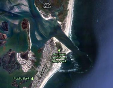
Tsunami-Like Wave In New Jersey Being Investigated.
It must have been a fairly small "tidal wave". I don't remember the
cable networks covering this (breathlessly) from sunrise to sunset.
Here's an excerpt from
nj.com: "
A
six-foot wave that crashed through Barnegat Inlet and swept three
people off a jetty and into the water earlier this month is being
investigated as a possible tsunami by federal officials, according to
the National Oceanic and Atmospheric Administration. The June 13 wave
was observed at over 30 tide gauges and a buoy throughout the
northwestern Atlantic Ocean, according to a report on NOAA’s website.
The cause of the incident is "complex and still under review," the
report said, but it is believed to have been connected to a strong
weather system known as a "derecho," which had passed through the area shortly before the wave was reported..."
Google Maps image credit: "
A
six-foot-wave that crashed through Barnegat Inlet in mid-June is
being investigated as a possible tsunami, federal officials said."
* The Wall Street Journal has more on the alleged tsunami
here (subscription may be required).
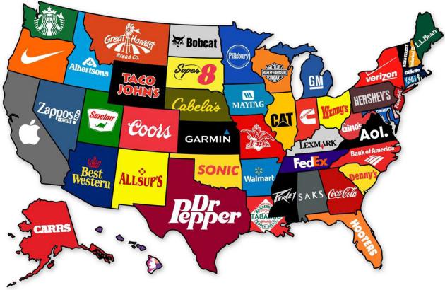
Map Shows The Most Famous Brand From Each State Of The U.S. Details from DesignTAXI.com: "Charts
and infographics website Maps on the Web has created a map that shows
the most famous brand to come from each state in the US. While the
origins of some popular brands, like Apple and Starbucks, are common
knowledge, others are less well-known—for instance, do you know that
Dr. Pepper is from Texas or that Hooters is a native of Florida? Do
you agree that the “most famous” brand from your state is as depicted on
this map?"
U.S. Pet Poll: Most Prefer Dogs; 18% Want Dinosaur.
This story gets the honor for most unusual (and terrifying) headline
of the week. Dinosaur? 20% of people polled would rather spend time
with their pets than people.
National Geographic has the story; here's the intro: "
Americans
love their pets—and a new poll shows just how much we dote on our
critters, while revealing some curious attitudes toward animals (and
people). Six out of ten voters interviewed have a pet, with a third
reporting that their critters sleep in the bed with them. (No word on
whether that includes reptiles.) Perhaps not surprisingly, one in five
people said they'd prefer to spend time with their animals than with
other people. (See pictures of pampered pets.) Fifty-two percent prefer dogs, 21 percent prefer cats, and 27 percent aren't sure which species they like better..."
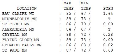
Feels Like Summer. A few optimistic bank
thermometers in the Twin Cities flashed 90 yesterday, in spite of the
official high at MSP International coming in at 89 F. 1.64" rain doused
Eau Claire, a trace of rain in Richfield, while St. Paul saw a
formidable .6" of rain from afternoon T-showers.
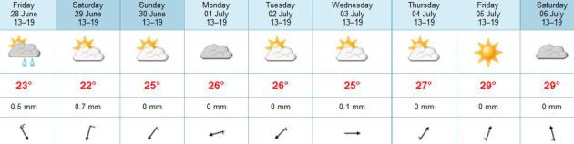
TODAY: Mix of clouds & warm sun. Dew point: 66 Winds: NW 15. High: 87
THURSDAY NIGHT: Clear and mild. Low: 66
FRIDAY: More clouds than sun, PM shower up north. High: 83
SATURDAY: Cooler with patchy clouds, a passing shower or two. Wake-up: 62. High: 74
SUNDAY: More sun, a bit milder. Dew point: 56. Wake-up: 58. High: near 80
MONDAY: Plenty of sun, still pleasant. Wake-up: 59. High: 82
TUESDAY: Sunny holding pattern. Still dry. Wake-up: 61. High: 83
WEDNESDAY: Partly sunny, seasonably warm. Wake-up: 63. High: 84
Climate Stories...
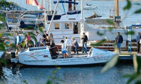
A Rowboat Expedition To The Arctic Made Possible By Climate Change.
The Guardian has the story; here's the intro: "
The Irish-Canadian team setting out next week to cross the Northwest Passage by row boat
knows full well the hazards of the fabled journey through the Arctic:
the unpredictable storms, the ice jams, the prospect of becoming prey
for a polar bear. "They are the only animal out there that will actively
hunt down a human being," said Kevin Vallely,
a veteran adventurer who is part of the expedition. The four-man crew
are due to set off in their 8-metre rowboat from Inuvik on 1 July, on a
journey meant to showcase the extreme effects of climate change on the Arctic..."
Photo credit above: "The Irish-Canadian team will set out on 1 July across the Northwest Passage." Photograph: Mainstream Last First
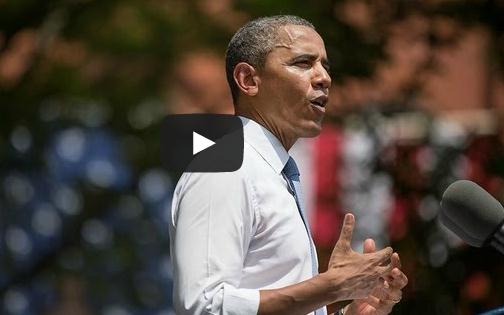
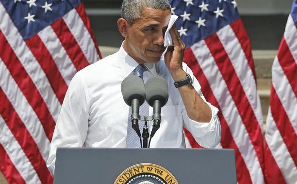
President Obama Speaks On Climate Change. Here is the complete Tuesday speech at Georgetown from
whitehouse.gov: "
President
Obama lays out his vision for a comprehensive plan to reduce carbon
pollution, prepare our country for the impacts of climate change, and
lead global efforts to fight it."
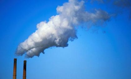
Obama Announces Sweeping New Global Warming Plan.
Mercury News has the story; here's a snippet: "
In
the most sweeping action the federal government has taken to date to
combat the warming of the planet, President Barack Obama on Tuesday
announced the nation's first mandatory restrictions on greenhouse gas
emissions from new and existing power plants. The new rules, a
centerpiece environmental initiative of Obama's presidency, follow the
lead that California set last year when it began to impose statewide
greenhouse gas limits on power plants, factories and other industrial
sources. Speaking at Georgetown University, Obama took a swipe at
climate deniers and described global warming as a major threat to the
nation's economy, farm production and its environment, noting that
severe storms, droughts and forest fires already are on the increase.
"We limit the amount of toxic chemicals like mercury and arsenic and
sulfur in our air and water," Obama said. "But power plants can still
dump unlimited amounts of carbon pollution into our air for free.
That's not right. That's not safe. And it needs to stop..."
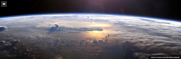
5 Takeaways From President Obama's Climate Speech. Here's a clip from
The Washington Post: "
What did we learn from President Obama’s climate speech Tuesday? Here are five takeaways.
1. He won’t duck the climate implications of Keystone XL, even though he may still end up approving it. Obama declared,
“Our national interest will be served only if this pipeline does not
significantly exacerbate the climate problem.” That means the
administration will be analyzing whether approving the project will
generate more greenhouse gas emissions than blocking it would. However
in its draft environmental impact assessment, the State Department
indicated that even if the president denies a permit to TransCanada to
build the project, the oil in Alberta may be shipped to the U.S. by
rail, leading to comparable emissions. So Obama’s final decision will
largely depend on how his deputies crunch the numbers..."
Image credit: NASA.
President Obama's Climate Speech: 10 Takeaways.
Politico.com has the story - he's an excerpt: "...
Obama
tried to get a cap-and-trade bill through Congress during his first
term, and in this year’s State of the Union address he gave lawmakers
one final ultimatum. “If Congress won’t act soon to protect future
generations, I will,” he said in the February speech.
“I will direct my Cabinet to come up with executive actions we can
take, now and in the future, to reduce pollution, prepare our
communities for the consequences of climate change and speed the
transition to more sustainable sources of energy.” But even at the time,
the universal expectation
was that Congress had zero chance of passing any serious climate
legislation. His rollout Tuesday acknowledged that reality. Now, the
president is directing agencies from the Department of Agriculture to
the EPA to take action — with the main onus falling on the EPA..."
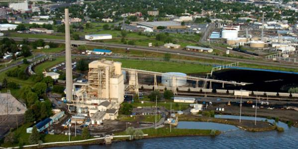
Photo credit above: "
Coal-fired power plants will take a big hit under the president’s plan." AP Photo
"We Need To Act". Obama's Climate Fight Draws A Green Line On Keystone. Here's an excerpt from a story at
The Atlantic Wire: "...
Eventually
he turned to politics, and the need for action, not denial. "We
don't have time for a meeting of the Flat Earth Society!" he
exclaimed. "Sticking your head in the sand may make you feel safer,
but it won't keep you safe from the coming storm." He demanded that
the Senate approve Gina McCarthy,
his nominee for administrator of the EPA, and asked Americans to
"broaden the circle of those willing to stand up for the future" by
championing his plan in their communities. By cutting away early, the
networks missed what was perhaps the most unexpected bit of news Obama
laid out: that he would insist that the Keystone XL pipeline not
result in an increase in greenhouse gas emissions. Even last night,
during a call the administration held with members of the media, it
was suggested that Keystone wouldn't be a topic of conversation. That
the president would draw a red — or, rather, green — line on the
controversial proposal was only revealed shortly before the speech..." (photo: AP).


No comments:
Post a Comment