84 F. high in the Twin Cities Tuesday.
82 F. average high on June 25.
77 F. high on June 25, 2012.
20.39" precipitation since January 1 in the Twin Cities.
13.11" average precipitation since January 1, to date.
Storms with Names
What happened to late afternoon, garden-variety
popcorn showers and T-showers? We still see them, of course, but now
(increasingly) we have to be on the lookout for their mutant relatives:
supercells, tornadoes, meso-convective swarms of T-storms that pop up at
night, and derechos.
Last Friday's wind damage was triggered by a
particularly aggressive bow echo, a powerful T-storm downdraft of rain
and hail-cooled air that reached the ground and spread out, fanning
straight-line wind damage.
Monday evening a much larger "derecho" swept
into Chicago, a much larger boomerang-shaped swirl of thunderstorms. To
be called a derecho a vast arc of storms has to travel at least 240
miles. June 29, 2012 one such derecho traveled 800 miles, from Iowa to
Norfolk, leaving millions without power.
The threat of heavy storms diminishes today as a
cool front turns on a drier northwest breeze. We salvage a dry sky
Thursday and Friday; a few pop-up instability T-showers Saturday
afternoon.
Sunday looks sunnier & drier. Keep your holiday weather
expectations low & you'll never be disappointed. It's that kind of
summer.
Right now models hint at 80s & isolated T-showers for the 4th. It may even feel like summer out there.
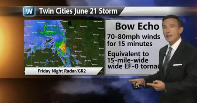
* image above courtesy of the Twin Cities
National Weather Service, which has a good explanation of Friday
evening's severe storm
here.
What Is A Derecho? Friday evening's severe wind
storm was triggered by a bow echo, powerful thunderstorm downdrafts
spreading out into violent straight-line winds at ground-level. A
derecho is an even larger phenomenon, a swirl of severe storms traveling
hundreds of miles over multiple states. Details in today's edition of
Climate Matters: "
After
historic derechoes rolled through Chicago and Minneapolis/ St. Paul,
we turn our attention to an increasing threat that is usually
downplayed because "it's just a garden variety thunderstorm."
WeatherNationTV Chief Meteorologist Paul Douglas explains that these are
different than normal thunderstorms, exactly what a derecho is, as
well as what causes them."
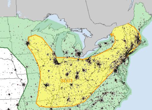
Wednesday Severe Threat. The best chance of
strong/severe storms this morning comes east of the Twin Cities, a
greater risk of hail and damaging winds from Chicago and St. Louis
across the Ohio Valley and much of the Northeast. Map: SPC.
Trending Slightly Drier. No cold fronts or stalled
storms/fronts in sight, just a drier day on Thursday and Friday, a risk
of more clouds and a few passing showers Saturday, then dry weather
Sunday into the 4th of July; heavy showers and T-storms just south and
west of Minnesota. I hope the ECMWF (European) model is right.
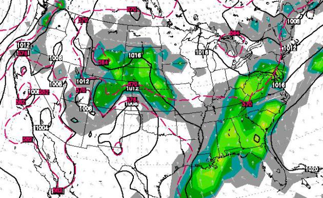
4th of July Outlook. Here is
the ECMWF model outlook for midday on the 4th of July (next Thursday),
showing a few showers and T-storms over the central and northern Plains,
with a risk of a shower or T-shower over southern Minnesota. It's way
too early to get specific, but showers and storms seem likely east of
the Appalachians, with a better chance of puddles south/west of
Minnesota. We'll see. Model map: WSI.
Not All Of The Corn Belt Is Wet. Check out the rainfall amounts over southeastern Minnesota in this post from
The Illinois Climatologist: "
Here
is the latest map of 90-day precipitation departures from average
across the Midwest. The greens, blues, and purple show areas that were 2
to 12 inches above average. That is the dominate feature of much of
the western and central Corn Belt. Meanwhile, the areas in light tan
and yellow in southeastern Indiana, southern and eastern Ohio, and
small patches in Kentucky and southern Illinois show areas that are 1
to 4 inches below average. The dry areas are nowhere near as severe as
2012. However, it is worth watching as we move through the growing
season." (map: Midwestern Regional Climate Center).
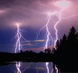
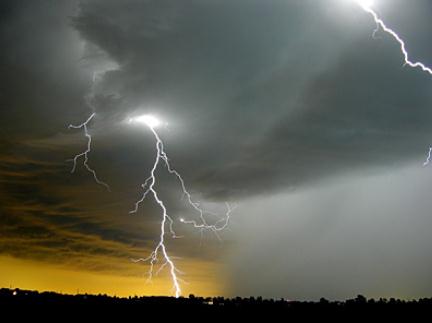
Fishing Tops List Of Lightning Death Activities.
Another good reason to have a few radar apps on your smart phone in the
boat, or a portable NOAA Weather Radio with you. Here's more from
Yahoo News: "
Most
lightning deaths in the United States occur while people are enjoying
outdoor activities, with fishing the most deadly, government weather
officials say. From 2006 to 2012, 238 people died after being struck by
lightning in the country — 82 percent of them male. Of the total number
of victims, 152 were taking part in leisure activities, according to
new findings from the National Weather Service . Fishing topped the
list with 26 lightning
deaths, followed by camping with 15 deaths, boating with 14, soccer
with 12 and golf with eight, NWS officials said. Other lightning victims
died while at the beach, swimming, walking, running or picnicking. [Electric Earth: Stunning Images of Lightning]
Activities like fishing and camping may be most hazardous during a
storm because they often require extra time to take shelter in a safe
place, explained John Jensenius, a lightning safety specialist with the
NWS..." (photo image: discovery.com).
Cleaner Air Linked To More Hurricanes. Here's a snippet of an interesting story at
The Telegraph: "
Researchers
from the Met Office established a direct link between levels of
industrial pollution and the frequency of hurricanes in the North
Atlantic. For much of the 20th century, sooty pollution in the
atmosphere has made conditions unfavourable for the storms, causing
their numbers to drop. But since the 1980s, cleaner air over the
Atlantic has created better conditions for hurricane formation, with
more tropical storms developing and battering American and Caribbean
coasts as a result..."
Lessons Learned From The June 21 Mega-Storm. Last
Friday evening's bow echo, severe winds and flooding rains were a subtle
(yet blunt) reminder that damage from severe thunderstorms can be even
more extensive than a tornado touch-down. The latest edition of
Climate Matters is here: "
It
wasn't a tornado, but hurricane force winds combined with a saturated
ground that led to widespread damage and the largest power outage in
Minnesota's history. Friday night's storm was the equivalent of a
15-mile-wide EF-0 tornado, and WeatherNation Chief Meteorologist Paul
Douglas says it serves as a reminder that you need to take severe
thunderstorms seriously."
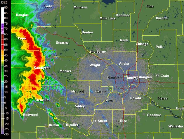
Extra Severe. A
radar loop from Friday evening's bow echo (courtesy of NOAA) shows a
severe gust front as rain and hail-cooled air rushed east at 50 mph. A
few thoughts from Friday's severe gust front:
* Sirens are not sounded for Severe Storm Warnings (with the exception of Dakota County).
* Tornadoes get more attention, but severe storms can be just as destructive.
Damage is often more extensive, but not as severe as in a major
tornado. To put things into perspective, the damage left behind from
Friday's 70-80 mph gust front was roughly equivalent to an EF-0
tornado, one that was 15-20 miles wide. At some point it becomes a
matter of semantics: did a tornado or a severe storm gust front bring
down that big tree in your yard?
* The supercell thunderstorm
that morphed into a bow echo raced east at 50 mph, moving faster than
high-res models were predicting. Winds gusted over 60-70 mph over
portions of Hennepin County for 10-15 minutes. The persistence of the
high winds, coupled with wet, saturated ground from early morning
storms, helped to bring down even more trees.
* This rotating supercell was
able to sustain itself, keeping the rain and hail-cooled gust front
intact for several hours, prolonging the damage. A typical thunderstorm
self-destructs after 30-45 minutes, but spinning supercells can protect
the warm updraft, sustaining a storm for a long period of time.
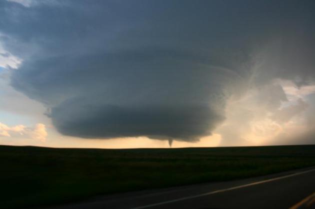
How Big Can A Tornado Actually Get On Earth? Good question: the (new) record is 2.6 miles wide, wind speeds around 300 mph. Here's an excerpt from
DVICE: ..."
We
don’t really know," tornado researcher Joshua Wurman of the Center for
Severe Weather Research told DVICE. "There are certainly extreme
limits; it’s unlikely you would get wind speeds greater than the speed
of sound, for instance. Whether they can even get close to that,
probably not. Nature is always trying to get rid of strong, anomalous
things. If there is an extremely strong wind, there are extremely string
dissipative forces seeking to get rid of that anomaly." By mapping
damage on either side of the storm’s path, weather spotters determined
the El Reno twister spanned 2.6 miles across as it raged over 16.2
miles of ground west of Oklahoma City May 31. With surface winds
greater than 200 miles per hour, it was hardly the most powerful tornado
ever recorded, however. The record-holder, on May 3, 1999, reached
wind speeds of 301 mph. That storm, incidentally, hit Moore, Okla.,
recently devastated in a powerful tornado a week before the El Reno
storm. It’s possible that about 300 mph is just about as powerful as
tornadoes get, Wurman said. The 1999 storm caused $1 billion in damage..."
Photo credit:
National Severe Storms Laboratory
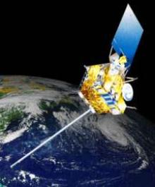
For Weather Satellites, Forecast Is Cloudy. Here's an update on the tenuous situation with America's weather satellites, courtesy of
news.gnom.es: "
As
hurricane season gathered force, the main U.S. weather satellite
watching the eastern seaboard failed last month for the second time in a
year. The difficulties with the seven-year-old weather satellite are a
symptom of a broader problem: Scientists are losing their orbital eyes
on Earth. Lee Hotz reports. Photo: AP. The main U.S. weather satellite
watching the eastern seaboard malfunctioned last month for the second
time in a year, underscoring the hazards of aging satellites that
monitor the planet as a threatening hurricane season gets under way..."
Lightning Safety. After concern was raised about
recent Little League baseball games played during questionable weather
(lightning observed nearby) I wrote this note to an ump who asked me
about criteria for calling off a game, and when it's safe to resume
play. Here is my reponse:
"With the recent spate of severe and damaging
thunderstorms impacting the metro area, I wanted to drop you a quick
note and remind you and your colleagues that lightning-related
fatalities are most likely at the very beginning and tail-end of an
outdoor event. This is where we see the most lightning-related injuries
and fatalities, not during the height of the storm, when heavy
rain/hail is falling.
Here’s the problem: lightning can travel 8-10 miles
in a horizontal direction. In fact every year people are struck with
blue sky overhead, a thunderstorm on the distant horizon. The National
Weather Service’s “30-30 Rule” has become a defacto standard in the
weather business. When you can count 30 seconds between lightning and
thunder it’s time to head for shelter; and wait 30 minutes after the last thunderclap before resuming safe play on the field.
“Because
electrical charges can linger in clouds after a thunderstorm has passed,
experts agree that people should wait at least 30 minutes after the
storm before resuming activities”.
I realize the wet spring has compressed the season,
and players (and their parents) are anxious to get these games in and
complete the season. However the overriding goal should be safe play
and lowering weather risk. Any temptation to “push the weather” and get
coaches, players (and spectators) out onto a ball field within 30
minutes of the last report of thunder is not only unsafe, but a
potential disaster in the making. From a litigation standpoint, there’s a
large and growing body of evidence that waiting 30 minutes
significantly increases safety margins and helps to avoid
lightning-related disasters. Taking a chance and resuming play within
that 30 minute window is a recipe for fatalities, life-long, chronic,
lightning-related injuries, and litigation.
As an interested parent who spent many long
weekends at the local ballpark with my two son (checking Doppler on my
smart phone more often than I would have liked) I have an interest in
safe play and taking any and all steps to reduce the potential for
weather-related tragedy."
- Paul Douglas, CBM Meteorologist. Founder of Media Logic Group.
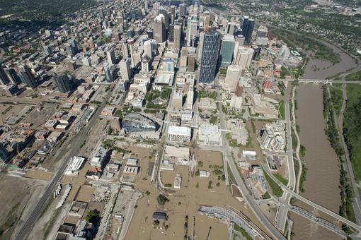
Alberta Flood Volunteers: "People Have Really Come Together".
Portions of Calgary are still underwater; this is reportedly the worst
flooding Alberta, Canada has experienced in recorded history.
CTV News has a story of the aftermath and clean-up operations underway: "
As
southern Alberta deals with the worst flooding in its history,
volunteers and staff with the Canadian Red Cross say they are working
around the clock to help those affected get through the crisis and begin
the cleanup. Matt Baden, a Red Cross emergency response team lead,
has been working at an emergency shelter in Blackie, just a few
kilometres east of High River, the community that was hardest hit by
the flooding. He says currently, the Red Cross is working to supply the
evacuees at the shelter with the basic necessities, such as cots,
blankets and hygiene kits, and to make people as comfortable as
possible..."
Photo credit above: "A flooded downtown
Calgary, Alberta is seen from a aerial view of the city Saturday, June
22, 2013. The two rivers that converge on the western Canadian city
of Calgary are receding Saturday after floods devastated much of
southern Alberta province, causing at least three deaths and forcing
thousands to evacuate." (AP Photo/The Canadian Press, Jonathan Hayward)
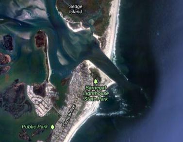
Tsunami-Like Wave In New Jersey Being Investigated.
It must have been a fairly small "tidal wave". I don't remember the
cable networks covering this (breathlessly) from sunrise to sunset.
Here's an excerpt from
nj.com: "
A
six-foot wave that crashed through Barnegat Inlet and swept three
people off a jetty and into the water earlier this month is being
investigated as a possible tsunami by federal officials, according to
the National Oceanic and Atmospheric Administration. The June 13 wave
was observed at over 30 tide gauges and a buoy throughout the
northwestern Atlantic Ocean, according to a report on NOAA’s website.
The cause of the incident is "complex and still under review," the
report said, but it is believed to have been connected to a strong
weather system known as a "derecho," which had passed through the area shortly before the wave was reported..."
Google Maps image credit: "
A
six-foot-wave that crashed through Barnegat Inlet in mid-June is being
investigated as a possible tsunami, federal officials said."
* The Wall Street Journal has more on the alleged tsunami
here (subscription may be required).
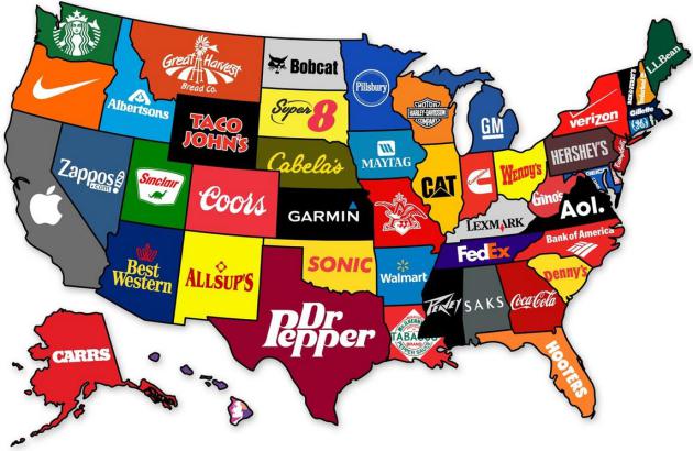
Map Shows The Most Famous Brand From Each State Of The U.S. Details from DesignTAXI.com: "Charts
and infographics website Maps on the Web has created a map that shows
the most famous brand to come from each state in the US. While the
origins of some popular brands, like Apple and Starbucks, are common
knowledge, others are less well-known—for instance, do you know that
Dr. Pepper is from Texas or that Hooters is a native of Florida? Do
you agree that the “most famous” brand from your state is as depicted on
this map?"
U.S. Pet Poll: Most Prefer Dogs; 18% Want Dinosaur.
This story gets the honor for most unusual (and terrifying) headline of
the week. Dinosaur? 20% of people polled would rather spend time with
their pets than people.
National Geographic has the story; here's the intro: "
Americans
love their pets—and a new poll shows just how much we dote on our
critters, while revealing some curious attitudes toward animals (and
people). Six out of ten voters interviewed have a pet, with a third
reporting that their critters sleep in the bed with them. (No word on
whether that includes reptiles.) Perhaps not surprisingly, one in five
people said they'd prefer to spend time with their animals than with
other people. (See pictures of pampered pets.) Fifty-two percent prefer dogs, 21 percent prefer cats, and 27 percent aren't sure which species they like better..."
TODAY: Passing shower or T-storm. Partial clearing later in the day. Winds: W/NW 10-15. Dew point: 71. High: 83
WEDNESDAY NIGHT: Partly cloudy, turning less humid. Low: 68
THURSDAY: Plenty of warm sun, more comfortable. Dew point: 65. High: 87
FRIDAY: Mix of clouds & sun. Dew point: 56. Wake-up: 64. High: 82
SATURDAY: Sunny start, then increasing clouds. Brief passing shower or T-shower. Wake-up: 62. High: 79
SUNDAY: More sun, more pleasant. Dew point: 55. Wake-up: 61. High: 81
MONDAY: AM sun, PM clouds increase. Wake-up: 62. High; 82
TUESDAY: Some sun, thunder far western MN. Wake-up: 63. High: 83
Climate Stories...
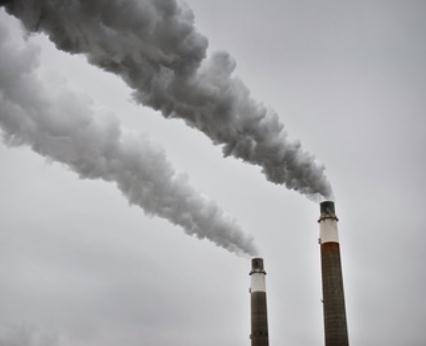
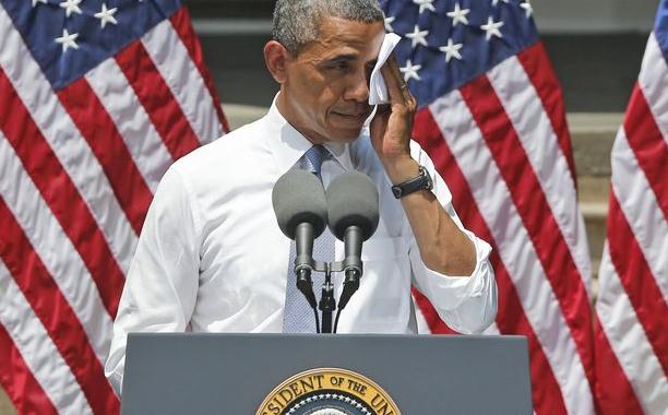
Obama Moves To Limit Greenhouse Gas Emissions Through Executive Order. Here's an excerpt from the
PBS NewsHour Tuesday evening:
GWEN IFILL: The president today renewed a pledge he
has been making since 2008 to reduce greenhouse gas emissions and slow
global warming. This time, he plans to exert executive authority to
force action. With today's announcement, the president zeroed in on the new and
existing power plants that burn coal and turn out 40 percent of the
nation's carbon dioxide emissions.
PRESIDENT BARACK OBAMA: As a president, as a father,
and as an American, I'm here to say, we need to act...Right now, there
are no federal limits to the amount of carbon pollution that those
plants can pump into our air. None. Zero. We limit the amount of toxic
chemicals like mercury and sulfur and arsenic in our air or our water,
but power plants can still dump unlimited amounts of carbon pollution
into the air for free. That's not right, that's not safe, and it needs
to stop..."
"We Need To Act". Obama's Climate Fight Draws A Green Line On Keystone. Here's an excerpt from a story at
The Atlantic Wire: "...
Eventually
he turned to politics, and the need for action, not denial. "We don't
have time for a meeting of the Flat Earth Society!" he exclaimed.
"Sticking your head in the sand may make you feel safer, but it won't
keep you safe from the coming storm." He demanded that the Senate approve Gina McCarthy,
his nominee for administrator of the EPA, and asked Americans to
"broaden the circle of those willing to stand up for the future" by
championing his plan in their communities. By cutting away early, the
networks missed what was perhaps the most unexpected bit of news Obama
laid out: that he would insist that the Keystone XL pipeline not result
in an increase in greenhouse gas emissions. Even last night, during a
call the administration held with members of the media, it was
suggested that Keystone wouldn't be a topic of conversation. That the
president would draw a red — or, rather, green — line on the
controversial proposal was only revealed shortly before the speech..." (photo: AP).
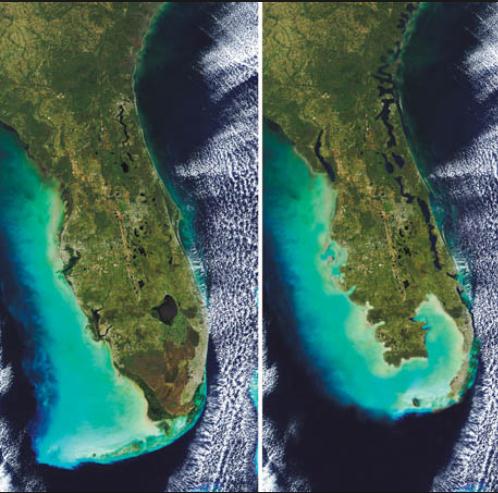
Goodbye Miami. From
Rolling Stone: "...
Sea-level
rise is not a hypothetical disaster. It is a physical fact of life on a
warming planet, the basic dynamics of which even a child can
understand: Heat melts ice. Since the 1920s, the global average sea
level has risen about nine inches, mostly from the thermal expansion of
the ocean water. But thanks to our 200-year-long fossil-fuel binge, the
great ice sheets in Greenland and Antarctica are starting to melt
rapidly now, causing the rate of sea-level rise to grow exponentially.
The latest research, including an assessment by the National Oceanic and
Atmospheric Administration, suggests that sea level could rise more
than six feet by the end of the century. James Hansen, the godfather of
global-warming science, has argued that it could increase as high as 16
feet by then – and Wanless believes that it could continue rising a
foot each decade after that. "With six feet of sea-level rise, South
Florida is toast," says Tom Gustafson, a former Florida speaker of the
House and a climate-change-policy advocate. Even if we cut carbon
pollution overnight, it won't save us. Ohio State glaciologist Jason
Box has said he believes we already have 70 feet of sea-level rise
baked into the system..." (image:
Phillip's Natural World).
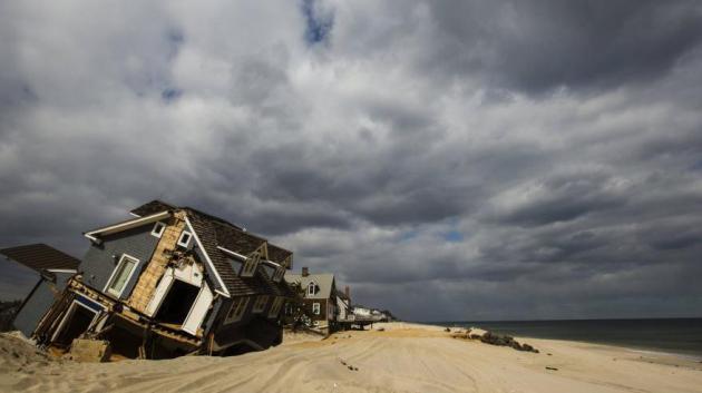
Introducing The New Profession Of Extreme Weather Architect. Yes,
the upward spike in T-storm winds, hail and flash flooding is already
impacting the way some architects design homes to better withstand
weather extremes. Here's an excerpt from
Quartz: "
Daniel
Horn, a fresh New York architecture graduate, has launched a global
competition around a tricky design question—what is the most aesthetic
way to raise the elevation of an entire neighborhood block by eight to
10 feet? Call it extreme weather architecture. Horn, a 23-year-old
graduate of the New York Institute of Technology (more on him below),
is part of a boom in design competitions and urban reconstruction
initiatives built around climate change. A rash of storms, drought and
fires in recent years has ignited this contemplation of a new school
of design cutting across cities and shorelines, homes and commercial
buildings. The emerging class of architecture suggests the onset of a
global design-and-construction industry worth tens of billions of
dollars in the coming years..."
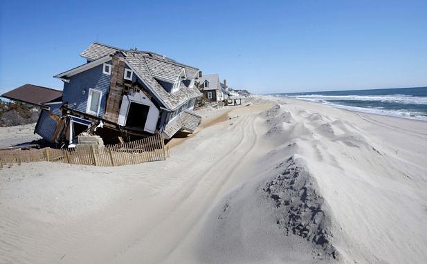
Photo credit above: "Mantoloking, New Jersey on March 22, 2013." Reuters/Lucas Jackson.
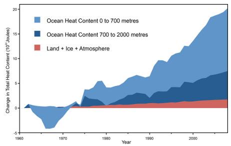
We Haven't Hit The Global Warming Pause Button. The Guardian has the story - here's an excerpt: "...
In
the 1980s and 1990s when air temperatures were warming in step with
the overall warming of the planet, that was fine. However, over the
past decade, the warming of surface air temperatures has slowed. At
the same time, the overall warming of the planet has continued, and if
anything it has accelerated.
This has been difficult to reconcile for those who previously
focused on surface air temperatures – what do we say about "global
warming" now? The result is a spate of articles from the New York Times, Washington Post, The New Republic, and Der Spiegel,
all of which get most of the facts right (including noting the
warming of the oceans), but that all begin from the premise that
"global warming" has slowed. It would be more accurate to say that
global surface air warming has slowed, but the overall warming of the Earth's climate has sped up..."
Graphic credit: "Global heat accumulation from Nuccitelli et al. (2012)".
Climate Change And The Alberta Flood. Is there a connection? Here's an excerpt of a story at Maclean's: "...Meanwhile,
there is the matter of the flooding in Alberta and to what extent
that flooding might be said to have been caused by climate change.
Jason Kenney says there’s no connection. Alberta hydrologist John Pomeroy says climate change was a factor. And Andrew Nikiforuk thinks this will prove a moment of realization for Albertans.
Albertans have also learned that climate change delivers two
extremes: more water when you don’t need it, and not enough water when
you do. The geographically challenged have also become learned, once
again, that water travels down hill and even inundates flood plains.
So climate change is not a mirage. Nor is it weird science or tomorrow’s news. It is now part of the flow of daily life."
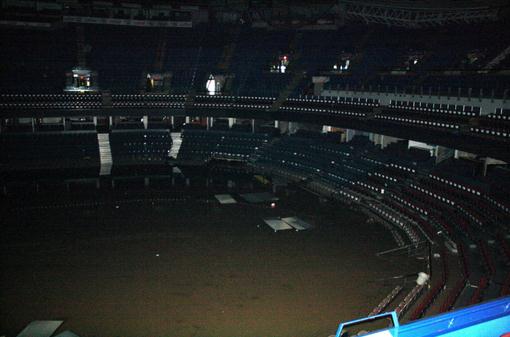
Photo credit: "
This undated photo provided by the Calgary
Flames shows the inside of the Calgary Saddledome in Calgary, Alberta.
The Saddledome, home to the National Hockey League's Calgary Flames,
was flooded up to the 10th row, leaving the dressing rooms submerged.
The two rivers that converge on the western Canadian city of Calgary
are receding Saturday, June 22, 2013 after floods devastated much of
southern Alberta province, causing at least three deaths and forcing
thousands to evacuate." (AP Photo/Calgary Flames).


No comments:
Post a Comment