Record Lows reported in St. Cloud and Rochester Sunday morning.
53 F. low Sunday morning in the Twin Cities.
75 F. afternoon high at MSP.
83 F. average high on July 28.
83 F. high on July 28, 2012.
Wednesday: probably the wettest day of the week, best chance of showers & T-storms.
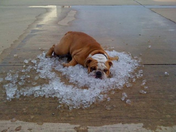
Dog Day Siesta
I really enjoy our Minnesota summers. Both
weeks. "Have you ever seen it this chilly in July?" my oldest son asked
me yesterday. No, but El Nino destroyed my long-term memory, so I can't
be sure of anything.
I was helping him move all his...stuff. Oh, to
be 25 and living in Uptown. And a perfect day for a move, more late
September than late July. At least we salvaged one nice day.
And no, this early (or late?) outbreak of
sweatshirts doesn't mean an early winter, or a particularly pernicious
winter is ordained. It may be my imagination but weather patterns &
jet stream configurations are very odd for mid-summer. A few notable
scientists suspect a link to rapid warming at far northern latitudes.
The maps I'm staring at aren't even close to being "normal" - for any
season.
Our weather trends cooler, drier & sunnier
than average the next 10 days as Canadian air leaks south in dribs and
drabs. T-storms arrive Wednesday, then a couple of cooler puffs:
Wednesday, again next weekend.
Today will be much too nice to work hard. Leave
early to enjoy 50-degree dew points & a few decorative cumulus
clouds. September is a spectacular month.
Maybe we'll see 3 Septembers in a row in 2013?
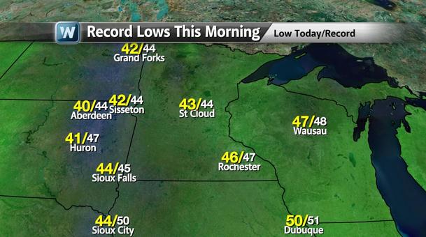
Sunday Records. Both St. Cloud and Rochester set
record lows Sunday morning. 43 F. in St. Cloud? I can't recall seeing
temperatures this cool over central Minnesota in July. It's still July
right? Map: WeatherNation TV.
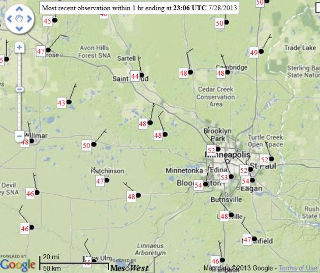
Saved By Stratus. Low clouds lingered much of
Saturday night, diminishing radiative cooling, preventing a rash of
record lows. Officially the Twin Cities missed a record by 2 degrees
Sunday morning (52 F). There were plenty of 40s, well away from the
urban heat island. Map: MesoWest.
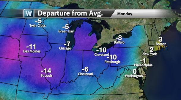
Monday Departures From Average. Most people I've
talked to don't miss the sauna-like heat or humidity, but a real cool
front in late July was a bit jarring for many of us. Highs today run
5-10 F. cooler than average from the Twin Cities and Des Moines to
Buffalo and Pittsburgh.
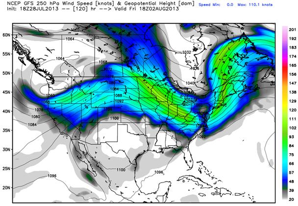
Cool Bias. 250 mb. winds midday Friday show
northwest winds over Minnesota and the Upper Midwest, Great Lakes and
New England, swamp-like heat confined to the Central and Southern
Plains. Northwesterly winds aloft may spill over into the first, even
the second week of August, limiting just how hot it can get looking out
10-14 days. Map: Weather Bell.
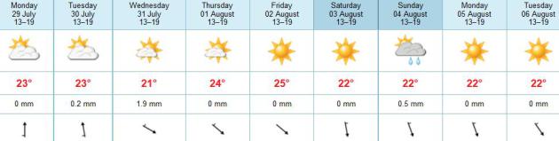
A Fine Week Of Weather. Today will be that day you
were daydreaming about back in early May (or Saturday for that matter). A
few showers and T-storms arrive late Tuesday into Wednesday, followed
by a series of cooler fronts: one arriving Friday, another over the
weekend. An isolated T-shower can't be ruled out Sunday. Temperatures
run about 2-4 degrees F. cooler than average into early next week.
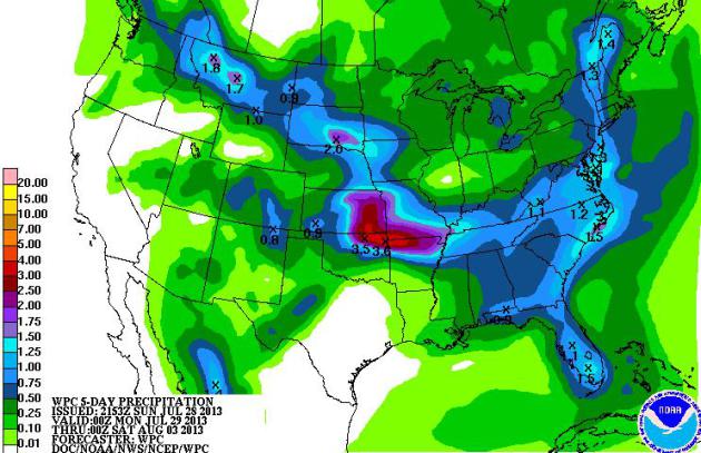
Soggy Central Plains To Outer Banks. NOAA HPC's
5-day rainfall forecast calls for some 3-4" amounts near Wichita and
Kansas City; potentially heavy showers and T-storms from the Mid
Atlantic region to Florida.
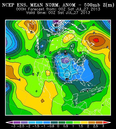
High Amplitude Pattern - 3 Sigma Deviation From Normal.
The north-south sweeps of the jet stream are highly unusual for late
July, over North America and Europe. According to Steve Scolnik at
CapitalClimate: "What is unusual for this time year is the huge
amplitude of the upper-level flow; over 3 sigma deviation from normal
over North America."
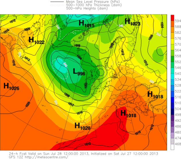
European Heat Wave. Highs are
forecast to soar to record levels again toda from Italy and Austria into
Germany and Poland, some mid to upper 90s possible as a huge ridge of
high pressure expands northward. The same high-amplitude pattern
affecting the USA and Canada is also showing up on the other side of the
pond. Map: meteocentre.com.
Weather Service Models Running On New, Vastly More Powerful Supercomputers. Meteorologist Jason Samenow at the Washington Post's
Capital Weather Gang has more information on the supercomputer upgrade; here's an excerpt: "
The
nation’s major weather forecasting models are now working their magic
on a new supercomputing powerhouse. On Thursday, the National Weather
Service (NWS) shifted its operational models onto a supercomputer
more than double the power of its predecessor, capable of performing
213 trillion calculations per second....The NWS has entered into a
bit of an arms race with the European Center for Medium-range Weather
Forecasting (ECMWF), which currently runs the more powerful and,
overall, more accurate global forecasting model. Following news of NWS’
planned computing upgrades in May, the ECMWF entered into a contract with supercomputer builder Cray to buy two new machines..."
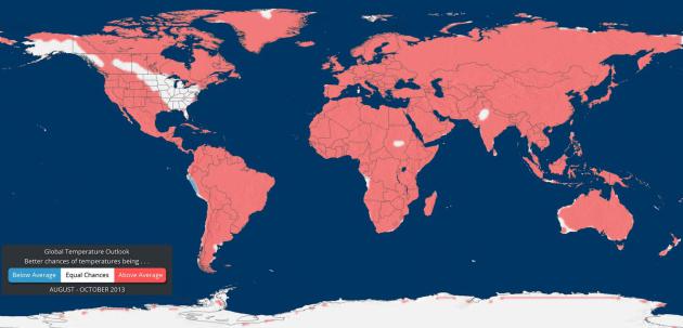
Autumn Outlook. The map above shows predicted temperature anomalies for the globe between August and October, courtesy of EarthNow and the
University of Wisconsin: "
The
data for the global temperature and precipitation outlooks are
provided by the International Research Institute for Climate and Society
(IRI). The IRI was established as a cooperative agreement between
NOAA’s Climate Program Office and Columbia University. It is part of The Earth Institute, Columbia University. The data for these maps are constructed primarily from several climate models, with some minor tweaks by climatologists."
20 Gripping Photos Of Extreme Weather.
Mashable
has the story (and remarkable photos). Here's the intro: "Although her
forces are still unmatched be even the most intelligent of man, we've
at least been able to document her mood swings. And, perhaps, we even
learn a thing or two about how to better understand her next time. We
pored over thousands of extreme
weather images to find out what Mother Nature had to say..."
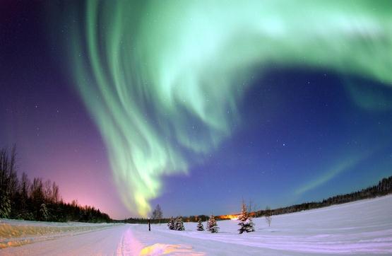
Photo credit above: "
Aurora Over Alaska: The
digitally enhanced photograph taken in January 2005 shows a
spectacular aurora borealis above the frozen landscape of Bear Lake,
Alaska. The image was voted Wikipedia Commons Picture of the Year for
2006." Image: Joshua Strang, USAF, Wikipedia, caption via NASA.
 The Nicest City In America
. That was the pronouncement in the WSJ over the weekend. Yes, Minneapolis was featured in the weekend edition of the
Wall Street Journal,
a suggested 4-day itinerary, hitting some of the most unique
restaurants, bars, culture and entertainment options. Not sure why they didn't
spend any time in St. Paul, but the story in the "Off Duty" section of
the WSJ was very complimentary. But we knew that already, right?
Here's an excerpt (subscription may be necessary to read the full text): "
This Midwestern city may bring to mind parkas before parks, and Vikings
before biking, but Minneapolis is as sweet in summer as it is frigid in
winter. The town is bisected by the Mississippi River and studded with
lakes, ponds and parks. If basking in the outdoors isn't your thing,
there is more than enough culture to fill a long weekend to overflowing:
daring architecture, a vital art scene anchored by the
contemporary-focused Walker Art Center and restaurants that deftly
combine modern technique with heartland comfort. (Here even the chicest
boîte is still sure to dish up some "Minnesota nice.") So whatever your
sensibility—Prince or prints, lamb tartare or lutefisk—a packed few days
in Minneapolis is bound to satisfy, you betcha..."
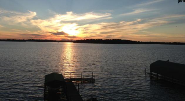
Photo credit above:
Ackerman + Gruber for The Wall Street Journal "
WATER VIEW // Explore Lake Harriet at sunset."
TODAY: Plenty of sun, very pleasant. Dew point: 55. Winds: S 10. High: 77
MONDAY NIGHT: Clear to partly cloudy. Low: 61
TUESDAY: More clouds & humidity. Dew point: 60. High: 81
WEDNESDAY: Showers & T-storms likely. Wake-up: 65. High: 79
THURSDAY: Sunny, less humid. Dew point: 57. Wake-up: 60. High: 81
FRIDAY: Partly sunny, probably dry. Wake-up: 63. High: 80
SATURDAY: Blue sky, comfortable. Dew point: 53. Wake-up: 61. High: 79
SUNDAY: More clouds than sun, lukewarm. Wake-up: 60. High: near 80
Climate Stories...
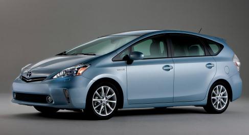
June 2013 Is Best Month Yet For Electric Car Sales. Details from
EVWORLD.com: "
Almost 9,000 plug-in electric vehicles have been sold in the U.S. during June of this year, bringing the total in the last 30 months to 110,000 plug-in electric cars.
If you think you've been seeing more Teslas and Nissan Leafs on the
streets, it's not your imagination -- there really are more of them on
our roads. Just in the month of June of this year, almost 9,000 plug-in
electric vehicles have been sold in the U.S. This adds to more than
110,000 plug-in electric vehicles that have been sold in this country in
the last two and a half years, the Electrification Coalition reports.
The Electrification Coalition is a nonprofit group composed of business
leaders and industries, from battery manufacturers to automakers, and
promotes the use of electric vehicles on a mass scale..."
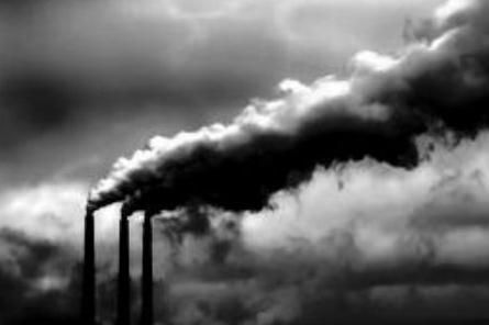
Carbon Dioxide Power Plants: Could The Greenhouse Gas Be Used To Generate Electricity? Mother Nature Network and
Huffington Post have the story; here's an excerpt: "
Here's
an interesting idea: What if the carbon dioxide (CO2) produced by
power plants while they generate electricity could be converted into a
source of additional electricity? That's the idea behind a new paper
published this week in the journal Environmental Science &
Technology Letters. Written by a team of researchers in the Netherlands,
the paper describes how CO2 could be mixed with a fluid electrolyte,
generating electrical energy in the process. A press release from the
American Chemical Society, which publishes the journal, calls this a
"trash-to-treasure" story, saying it could help produce billions of
kilowatts of energy every year while reducing the amount of greenhouse gases released into the atmosphere..."
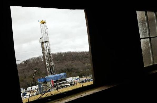
Internal EPA Report Highlights Disputes Over Fracking And Well Water. The Los Angeles Times
reports on internal conflicts and disagreements at the EPA over the
fracking (hydraulic fracturing) and water safety; here's the intro: "
One
year ago, the Environmental Protection Agency finished testing
drinking water in Dimock, Pa., after years of complaints by residents
who suspected that nearby natural gas production had fouled their wells.
The EPA said that for nearly all the 64 homes whose wells it sampled,
the water was safe to drink. Yet as the regulator moved to close its
investigation, the staff at the mid-Atlantic EPA office in
Philadelphia, which had been sampling the Dimock water, argued for
continuing the assessment. In an internal EPA PowerPoint presentation
obtained by the Tribune/Los Angeles Times Washington Bureau, staff
members warned their superiors that several wells had been contaminated
with methane and substances such as manganese and arsenic, most likely
because of local natural gas production..."
Photo credit above: "
A natural gas fracking operation on
leased farmland near Dimock, Pa. The EPA says water from most wells in
the area is still safe to drink, but critics and an internal EPA report
suggest that the drilling method is causing methane contamination."
(Caroline Cole / Los Angeles Tiems / December 27, 2011).
Potential Well Water Contaminents Highest Near Natural Gas Drilling, UT Arlington Study Says. Esciencenews.com has the story; here's the intro: "A
new study of 100 private water wells in and near the Barnett Shale
showed elevated levels of potential contaminants such as arsenic and
selenium closest to natural gas extraction sites, according to a team of
researchers that was led by UT Arlington associate professor of
chemistry and biochemistry Kevin Schug. The results of the North Texas
well study were published online by the journal Environmental Science
& Technology Thursday. The peer-reviewed paper focuses on the
presence of metals such as arsenic, barium, selenium and strontium in
water samples. Many of these heavy metals occur naturally at low levels
in groundwater, but disturbances from natural gas extraction
activities could cause them to occur at elevated levels..."
Gangplank To A Warm Future. Here's a snippet from a
New York Times Op-Ed: "
As a longtime oil
and gas engineer who helped develop shale fracking techniques for the
Energy Department, I can assure you that this gas is not “clean.”
Because of leaks of methane, the main component of natural gas, the gas
extracted from shale deposits is not a “bridge” to a renewable energy
future — it’s a gangplank to more warming and away from clean energy
investments. Methane is a far more powerful greenhouse gas than carbon
dioxide, though it doesn’t last nearly as long in the atmosphere.
Still, over a 20-year period, one pound of it traps as much heat as at
least 72 pounds of carbon dioxide. Its potency declines, but even after
a century, it is at least 25 times as powerful as carbon dioxide. When
burned, natural gas emits half the carbon dioxide of coal, but methane
leakage eviscerates this advantage because of its heat-trapping power..."
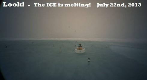
North Pole Lake Found By Environmental Observatory, May Be Evidence Of Global Warming (Photo). International Business Times has the story; here's the intro: "
The freezing tundra that was the North Pole is now home to a lake. A picture, obtained by the North Pole Environmental Observatory
this week, shows a shocking wide-angled photograph of the location’s
newest lake, possible evidence of global warming. According to experts,
this isn’t the first or the most severe water mass to appear in the
northern hemisphere. “I have seen much more extensive ponding,”
principal investigator for the North Pole Environmental Observatory,
James Morison, told The Atlantic
Wednesday, who said the image is misleading. “Because we use
wide-angle lenses, the melt pond looks much bigger than it is,” he
said. The lake, which was photographed by the observatory’s weather
buoy-attached camera Monday, is reportedly a result of the longtime
decline of sea ice in the region due to global warming and the more
recent increase in land temperature..."
Photo credit above: "
A newly discovered lake in the North Pole was photographed by the North Pole Environmental Observatory Monday." Facebook
The Truth Behind That $60 Trillion Climate Change Price Tag. A staggering number indeed - alarmist hype, or within the realm of scientific possibilty? Here's a clip from
takepart.com: "
This week, news broke that if all the methane off the East Siberian seafloor was released, the fallout would cost $60 trillion—a
huge, staggering number. For comparison’s sake, the world’s GDP is
$70 trillion. The findings assume that 50 gigatons of methane would
be released over the course of 10-to-20 years in a warming
pulse....Very large numbers make us sit up and take notice, but
they’re also hard to grasp. What is climate change currently costing
even without that warming pulse? A NRDC report
estimates that American taxpayers, through the federal government,
paid $100 billion in 2012—more than the cost of education or
transportation. (And that doesn’t include what state and local
governments, insurers, or private citizens paid.) Mann estimates the
global cost at $1.4 trillion per year in coastal damage, droughts,
fires, floods and hurricanes..."
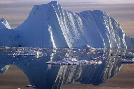
Photo credit above: "
An iceberg carved from a glacier floats in the Jacobshavn fjord in south-west Greenland." (Photo: Konrad Steffen / Reuters).
Adapt, Move Or Die: The Pressures Of Global Warming. Here's the intro to a story at Australia's
The Conversation: "
We
all know that weather is not the same as climate, but it is
surprising how our perceptions of global warming vary according to what
we see outside our window. In the UK for example, last year’s
washed-out summer took the focus off global climate warming in many
people’s minds – maybe the current heatwave will change that. But
regardless of what may be happening in our back yards, the long term
trend is one of warming – which it has done globally by an average of
0.74C˚ over the past century.
As the climate warms up, animals and plants have three main
alternatives: they can either move to track the temperature, stay put
and adapt to the warming, or die. Responding to variation in climate is
not a new phenomenon for species – after all, many species responded
to climate warming after the last ice ages..."
Photo credit above: "
Don’t want to move home?"
MissTessmacher.
Global Warming And The Future Of Storms.
The Guardian has the story, co-authored by St. Thomas climate scientist John Abraham. Here's an excerpt: "...
I asked Dr. Emanuel to summarize the present understanding of hurricanes, and he responded with the following insights:
• The incidence of high-intensity tropical cyclones
(Safir-Simpson categories 3-5) should increase, and the amount of
rainfall in these storms should increase, upping the potential for
freshwater flooding. These changes will not necessarily occur where
tropical cyclones develop and thrive today. "Indeed," wrote Emanuel,
"it is likely that there will be decreasing activity in some places,
and increasing activity in others; models do not agree on such
regional changes."
• Though experts disagree on this point, Emanuel's work suggests
that weak events (tropical storms and Cat 1-2 storms) will become
more frequent.
• "Very little work has been done on the problem of storm size,"
wrote Emanuel, "what little research has been done suggests that
storm diameters may increase with global temperature. This can have a
profound influence on storm surges, which are the biggest killers in
tropical cyclone disasters..."
Photo credit:
Dr. Kerry Emanuel, MIT.


No comments:
Post a Comment