79 F. high in the Twin Cities Monday.
83 F. average high for July 29.
80 F. high on July 29, 2012.
Saturday: nicer, sunnier, drier day of the weekend.
2-6 F. temperatures run a few degrees below average into at least the first week of August.
Beware of... Flossie?
Tropical Storm Flossie is roughing up Hawaii
with flooding rains and surging seas at this hour. I know, "Flossie"
sounds like a dentist's mascot. Ironically, this Flossie is taking a
path almost identical to another Hurricane Flossie in 2007, a Category 4
that passed south of Hawaii. Once a decade Hawaii gets a sloppy
tropical smack. The last devastating storm? Iniki in 1992.
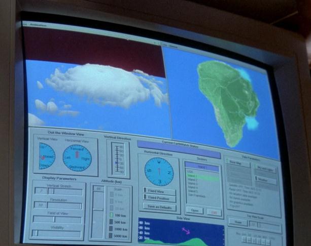
Jurassic Park. The computer screen image above, courtesy of
jplegacy.org,
shows the EarthWatch (previous company) storm imagery from Hurricane
Andrew that was superimposed over the mythic island of Jurassic Park to
create the special effects Spielberg wanted for the movie. Top image
courtesy of Universal Studios.
While filming the movie "Jurassic Park"
Hurricane Iniki pummeled the island chain. It was a close call. "We were
at the Westin on Kauai, and they told us to seek shelter in the
basement" Steven Spielberg told me many years ago. The basement? That
works in a tornado, but in a hurricane a vertical evacuation is safest -
the 3rd or 4th floor of a well-constructed building.
Morning showers herald the approach of a warmer
front today; more numerous T-storms Wednesday as another puff of
Canadian air approaches. Comfortable sunshine spills over into next
weekend, highs in the 70s to near 80. About as good as it gets.
Check the blog below for updates on "Dorian",
which may regain tropical storm force soon as it moves into an area of
warmer ocean water and weaker wind shear. Some models drift Dorian into
south Florida, possibly the eastern Gulf of Mexico by the weekend - and
there's a chance it could be a hurricane by then. Stay tuned.
"...
According to NASA, Greenland and Antarctica are losing three
times as much ice each year as they did in the 1990s. Summer sea-ice
cover is half as big as it was from 1979 to 2000, and many scientists
are predicting an ice-free Arctic by the end of the decade. Not so
long ago, the Northwest Passage, the storied northern route from the
Atlantic to the Pacific oceans, required an icebreaker ship to navigate
it. This summer, people are attempting the passage in a sea kayak..."- from a Rolling Stone article; details below.
A Hot Weather Hiatus. I still
don't see anything hot or humid through the first week of August,
possibly longer. ECMWF guidance shows a dry, comfortable spell (upper
70s and low 80s) from Thursday into Saturday (nicer day of the weekend).
Another cool front is shaping up for the first half of next week, highs
in the low to mid 70s.
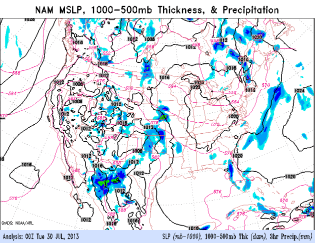
Partial Relief Northern USA - Will Dorian Redevelop?
The 84-hour NAM model data (courtesy of NOAA) shows the soggy remains
of Dorian regenerating into a possible tropical storm, approaching
Florida as early as Florida. I'm not so sure. The storm will have to
overcome persistent wind shear to have a chance of redeveloping into a
tropical storm. Showers and T-storms are most likely from the Central
Plains into the Ohio Valley, the next cool push sparking a soggy spell
for the East Coast by Wednesday and Thursday.
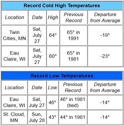
Weekend Temperature Records. No, I really don't want
to dwell on this, but it's worth recapping that MSP did, in fact, set a
record for the coolest July 27 on record, with a high of only 64F. St.
Cloud set a record on Sunday for the chilliest morning low ever recorded
on July 28. Data courtesy of the Twin Cities National Weather Service.
A First - Fur In July. Before I get flamed by PETA
let me assure you that I have no idea if that's real fur or not.
Regardless, thanks to Nancy Jamieson from Bloomington for reminding us
how chilly Saturday was - 50s much of the day at MSP. Good grief.
More Football Weather Than Baseball Weather. Thanks
to my friend and former colleague Sonya Goins for sending in this photo
from a Friday night (baseball) game. A July to remember....or forget.
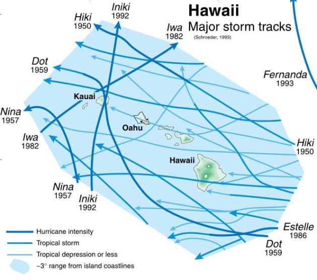
Hawaii Hurricane Tracks. Hurricanes are relatively
rare in Paradise (or as close as we can come in the USA). The last
devastating hurricane was "Iniki" in 1992, which swept in from the
south. Source: USGS.
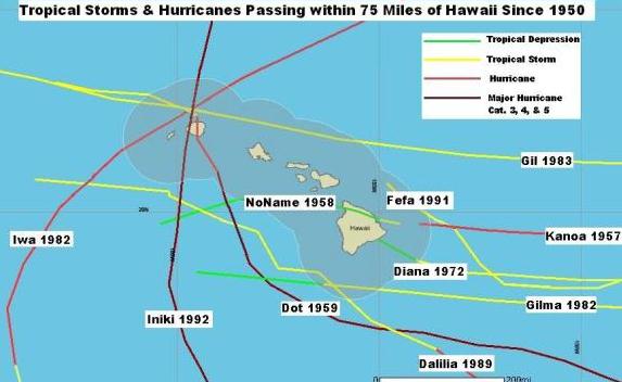
Significant Hawaiiian Storms Since 1950. Kanoa, Fefa, Diane and Gilma took paths similar to Flossie, according to NOAA data.
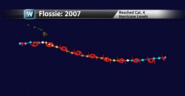
Deja Vu - All Over Again. I was surprised to see
that another Flossie threatened the Hawaiian Islands back in 2007. This
one was a Category 4 hurricane with 140 mph sustained winds - mercifully
the storm weakened and passed south of Hawaii. The storm name wasn't
"retired" because it didn't result in severe damage and/or loss of life.
Thanks to Aaron Shaffer and WeatherNation TV for passing this nugget
along.
More Perspective On Hawaiian Hurricanes. Matt Daniel has some very good information and context in his WeatherGlobe segment at
EarthSky.org; here's an excerpt: "...
Hawaii
rarely sees tropical cyclones directly affecting the region. The last
time a tropical storm struck Hawaii directly was back in 1958. There
have been hurricanes and tropical depressions that have impacted Hawaii
after 1958, but not from a direct hit by a tropical storm. The last
major tropical cyclone to affect Hawaii was Category 4 Hurricane Iniki
in 1992, which was the most damaging hurricane to strike the Hawaiian
Islands in recorded history. A large majority of the tropical systems
that have affected Hawaii never actually made a direct landfall on one
of the islands. As you can see in the image above, direct tropical
cyclone hits are a rare occurrence..."
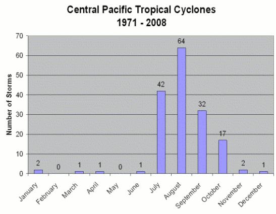
Image credit above: "
Climatology for tropical cyclones in the Central Pacific Ocean." Image Credit: NOAA.
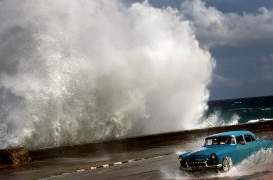
Hurricane Tips From Cuba. The USA and Cuba are cooperating in at least one area: meteorology - as reported by
The New York Times: "...
This
shared destiny has led to a rare truce between the two nations, which
have had no bilateral relations for more than 50 years. Their
meteorological agencies exchange satellite data, jointly analyze radar
and collaborate on storm forecasting. When a storm is approaching, “we
call the National Prognostic Center or they call us, whoever gets to
the phone first,” said Lixion Avila, a senior specialist at the United
States government’s National Hurricane Center.
Dr. Avila called Cuba one of the United States’ most valuable
meteorological partners. “Cuba has a long history of excellent
forecasting with a tremendous record of data,” he said..."
Photo credit above: Ramon Espinosa/Associated Press. "
A driver in Havana during Hurricane Sandy last year, which dealt a huge blow, Killing 11 people."
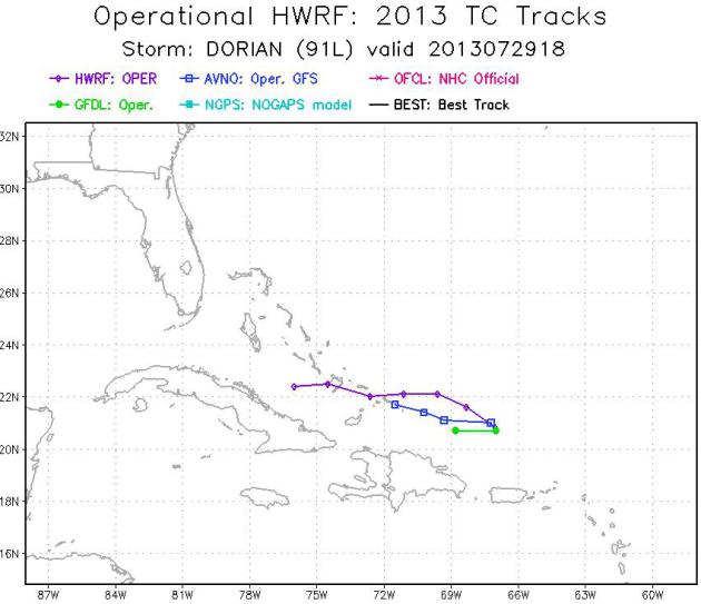
Will Dorian Intensify? Models are literally all over
the map, but NOAA's newest, most powerful model, the HWRF (purple
track) shows the storm reaching Cuba within 72 hours. Source: NOAA NCEP.
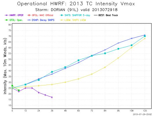
Dorian Intensity. The same HWRF model (purple) shows
Dorian's wind speeds decreasing over time - other models show
intensification. This is why meteorologists get migraines and tug at
gray hairs.
Heatwaves Will Make Crops Produce Smaller Grains.
Much of Europe is wilting from extreme heat, experiencing the same
weather whiplash as much of the USA, veering from drought to flood, back
to drought.
The Guardian has the story - here's a clip: "
The
wheat is usually green at this time, but its already gone brown," says
Laurence Matthews, overlooking a bone-dry and dusty field on his
3,000-acre farm near Dorking
in Surrey. "It's like a tinderbox: there's a real risk of fire." The
summer heatwave is having a dramatic effect on his crops. "Without
water, the plants just shut down," he says. But it is the twists and
turns of increasingly erratic weather
that is making farming more difficult, Matthews says. "In spring 2012,
it was unbelievably dry and hot, then from April it just rained right
through to 2013, which made it very difficult to get our crops
established." The autumn-sown crops that survived the deluge developed
only short roots, as the soggy soils made drawing up water easier. But
the sudden heatwave this summer has left the crops without the deeper
roots they need to flourish. "We'll get smaller grains," he says..."
Photo credit above: "
Summer heatwaves are having dramatic effect on crops." Photograph: Gary Hawkins/Rex Features
How Big A Threat Is Car Hacking? Reuters has a hair-raising story, especially if you're driving a hybrid or EV right now; here's an excerpt: "
Car
hacking is not a new field, but its secrets have long been closely
guarded. That is about to change, thanks to two well-known computer software hackers who got bored finding bugs in software from Microsoft and Apple. Charlie
Miller and Chris Valasek say they will publish detailed blueprints of
techniques for attacking critical systems in the Toyota Prius and Ford Escape in a 100-page white paper, following several months of research they conducted with a grant from the U.S. government..."
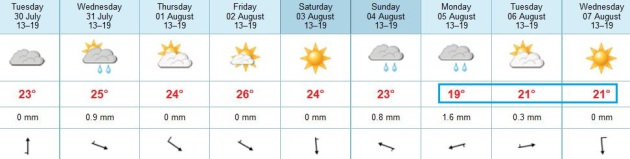
TODAY: AM showers, patchy clouds with peeks of PM sun. Dew point: 60. High: 75
TUESDAY NIGHT: An isolated shower or T-shower possible. Low: 62
WEDNESDAY: Unsettled, more humid with a better chance of T-storms. Dew point: 64. High: 78
THURSDAY: Blue sky, less humidity. Dew point: 52. Wake-up: 58. High: near 80
FRIDAY: Partly sunny, still pleasant. Wake-up: 59. High: 81
SATURDAY: Probably the nicer day of the weekend. Plenty of sun, comfortable. Dew point: 54. Wake-up: 57. High: 79
SUNDAY: Clouds increase, showers and T-storms late. Wake-up: 58. High: 78
MONDAY: Showers & T-storms, a potentially soggy day. Wake-up: 60. High: 74
Climate Stories...
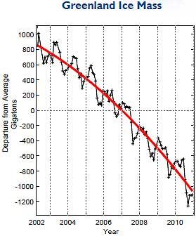
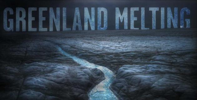
Greenland Melting. Did soot from wildfires in
Colorado and Canada help to accelerate ice melt over Greenland last
year? Here's another eye-opening article from
Rolling Stone,
focused on the rate of melting in Greenland, implications for sea level
rise, and Jason Box, whose recent documentary "Chasing Ice" provided
start time-lapse images that made it hard to refute the dramatic changes
underway in the Arctic. Here's an excerpt: "...
It was all a tad
melodramatic, perhaps. But Box doesn’t shy away from bold strokes. As
he sees it, the general public has been betrayed by the reluctance of
climate researchers to speak about the dangers of climate change with
sufficient urgency. For Box, this has never been a problem. In 2009, he
announced the Petermann glacier, one of the largest in Greenland,
would break up that summer – a potent sign of how fast the Arctic was
warming. Most glaciologists thought he was nuts – especially after the
summer passed and nothing happened. In 2010, however, Petermann began
to calve; two years later, it was shedding icebergs twice the size of
Manhattan. Another example: In early 2012, Box predicted there would be
surface melting across the entirety of Greenland within a decade.
Again, many scientists dismissed this as alarmist claptrap. If
anything, Box was too conservative – it happened a few months later. He
also believes that the climate community is underestimating how much
sea levels could rise in the coming decades...”
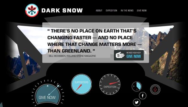
Taking Action. You can help fund Jason Box and his experiments in Greenland and the Arctic. His
Dark Snow Project
is using crowd-sourcing to accelerate the budgeting of trips necessary
to prove his theory: that man-made pollutants, including soot, are
accelerating Arctic snow and ice melt.
Still No Support For "Global Warming Slowdown". The
"no warming in the last 15 years" meme simply isn't grounded in science.
Ideology, superstition and wishful thinking - absolutely, but the data
doesn't support the claim, especially factoring deep-heating of the
world's oceans.
Discovery News has the story; here's a clip: "
A
new set of studies from the British government’s Meteorological Office
has addressed the claims by climate change skeptics that global
warming has “stopped” or “paused” or is “slowing down.” The claims
generally rest on two assertions: That global temperatures have either
been stagnant, or have increased very little, since roughly 1998; and
that new studies suggest that ‘climate sensitivity’ – the amount that
average temperatures are expected to increase in response to a doubling
of carbon dioxide in the atmosphere – may be lower than expected. The
Met Office’s response is a trio of reports that,
in style and length, resembles a set of ‘Climate Cliff Notes,’ and
which, taken in order, provide a step-by-step assessment of the
skeptical claims..."
* a 29 page PDF overview from the UK Met Office is
here.
More Wildfires = More Warming = More Wildfires. Another positive feedback loop, although the affects will be anything but positive, according to
Mother Jones. Here's an excerpt: "...
Scientists
have known for some time about the risk of large-scale carbon
emissions from thawing permafrost. But in recent years, they've become
increasingly attuned to an additional—and very worrisome—aspect of this
threat. As climate change proceeds, larger and more intense wildfires
are increasingly scorching and charring the forests of the north. While
these fires have always been a natural and recurring aspect of forest
ecosystems, they now appear to be undergoing a major amplification. And
that, in turn, may further increase the threat of permafrost thawing
and carbon releases—releases that would, in turn, greatly amplify
global warming itself (and potentially spur still more fire activity).
"You have this climate and fire interaction, and all of a sudden
permafrost can thaw really rapidly," explains Jon O'Donnell, an
ecologist with the National Parks Service's Arctic Network. Scientists
call it a "positive feedback," and it's one of the scariest aspects of
global warming because, in essence, it means a bad situation is making
itself worse..."
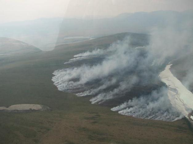
Photo credit above: "
A fire burns alongside a still frozen river in the Alaska wilderness." National Park Service.
Why It Finally Makes Political Sense To Talk About Climate Change.
There's a growing body of poll numbers and research that show that
voters, especially younger voters, care deeply about climate change, and
are more likely to vote for a candidate who acknowledges the science.
The National Journal has the story - here's a clip: "
The
administration is paying attention to polls showing that championing
climate policies is now potentially a political winner and—perhaps more
significantly—that denying the science that demonstrates human
activities cause climate change, as Republican candidates did in 2012,
is a clear political loser. In particular, White House officials are
heeding a poll released earlier this year by the Yale Project on
Climate Change Communication and the George Mason University Center for
Climate Change Communication. It found that 58 percent of registered
voters say they will consider a candidate’s position on global warming
when deciding how to vote; among that group, 83 percent say global
warming is happening, and 65 percent believe it is caused by human
activity. Just 5 percent of registered voters believe global warming
isn’t real and say that belief would influence their choice for
president..."


No comments:
Post a Comment