82 F. high in the Twin Cities Sunday.
83 F. average high on June 30.
92 F. high on June 30, 2012.
No rain for most communities into Saturday. First dry week of 2013?
4th of July: partly sunny, highs from 81-84, dew point near 60. Better than average.
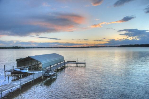
Good Timing
One of the nicest weeks of summer is shaping up for Minnesota, including the 4th of July. Quick, run out and buy a Lotto ticket.
After early May snows and June downpours I guess we were due for a break, statistically. Glad it's coming this week.
The jet stream is still "stuck", locked in a
pattern that favors thunderstorms capable of localized flooding from
Florida to New England through the end of the week, while the west fries
through historic heat. Already: 122F. Palm Springs, 119F in Phoenix -
the other night Las Vegas had a LOW of 89F.
In a deadly 1995 Chicago heat wave researchers
discovered it wasn't an afternoon heat index of 125F that caused the
most problems, but nighttime lows holding in the 80s that caused most of
the problems. People simply couldn't find any relief at night; their
hearts couldn't take the prolonged stress.
A stalled upper level low out east may squirt a
stray pop-up instability shower into southern Minnesota Wednesday &
Thursday, but I suspect most of us won't see any rain until Sunday, when
an advancing cool front sparks a few T-storms.
4th of July: intervals of sun, 80-85F, dew point near 60. Some of the best weather in the USA?
Really.
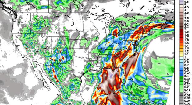
Rainfall Thru Thursday Morning.
The solution above shows the 12km NAM model accumulated rainfall
between Sunday evening and Thursday mroning at 12z, some impressive 2-5"
amounts pushing onto the Florida Panhandle, over 2" rain possible from
near Atlanta and Charlotte into interior New England. Meanwhile dry
weather should be the rule over the Upper Midwest and west coast of the
USA. Graphic: Weather Bell.
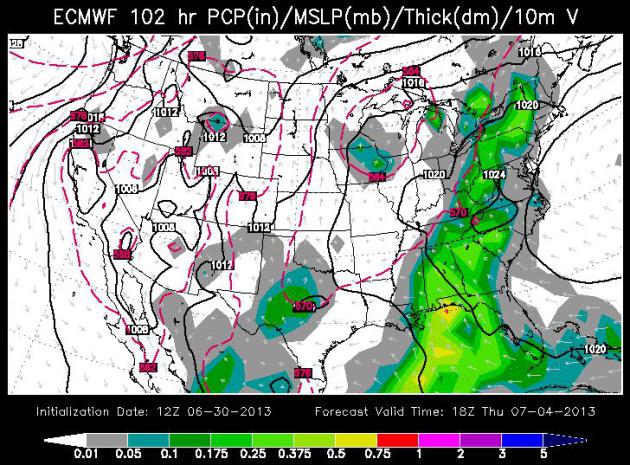
Best Week Yet? Is it even
theoretically possible to go more than 1-2 days in a row without rain
this year? I was starting to wonder. But if you put any stock in the
ECMWF (European) model above it looks fairly likely; dry weather
prevailing into Wednesday, probably Saturday. There is a slight chance
of a pop-up instability T-shower on the 4th, mainly south of the Twin
Cities, but I think most of us will go the entire week without
meaningful rain. Heresy.
4th of July. The ECMWF map
above (WSI Corp.) is valid midday Thursday, showing numerous showers and
heavy T-storms east of the Appalachians, a few spotty instability
T-storms popping up from near Rochester to Des Moines and the Quad
Cities, but fairly nice, sunny, seasonably warm weather is likely west
of the Mississippi for this year's 4th of July festivities, a little
monsoon cloud cover and rain taking the edge off the worst heat across
New Mexico and Arizona.
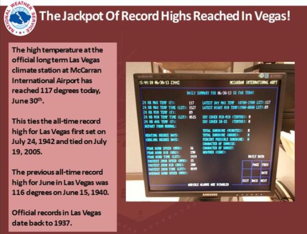
Record-Tying 117F at Las Vegas Sunday. There hasn't been a hotter day since official records in Sin City were started back in 1937. More
details from the Las Vegas National Weather Service.
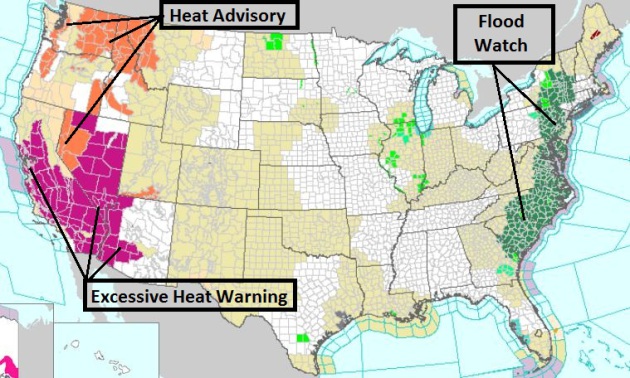
Record Heat West - Flooding Rains East.
The moisture contrasts across the USA are pretty formidable, record
heat in the west making a bad wildfire risk even worse - Excessive Heat
Warnings remain in effect from San Francisco and much of California and
Nevada to the Phoenix area. Out east a stalled frontal system has lead
to the issuance of a Flash Flood Watch from Hilton Head northward to
Albany. The latest watches and warnings from NOAA
are here.
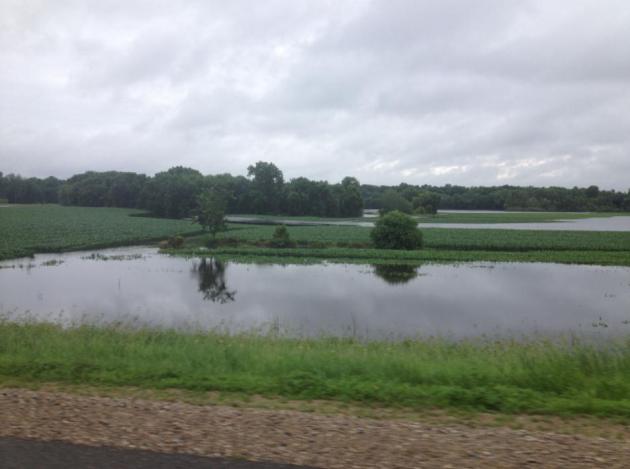
Lowland Flooding. Thanks to WeatherNation TV
meteorologist Todd Nelson for snapping this photo of the Crow River near
Rogers, experiencing significant flooding over the weekend.
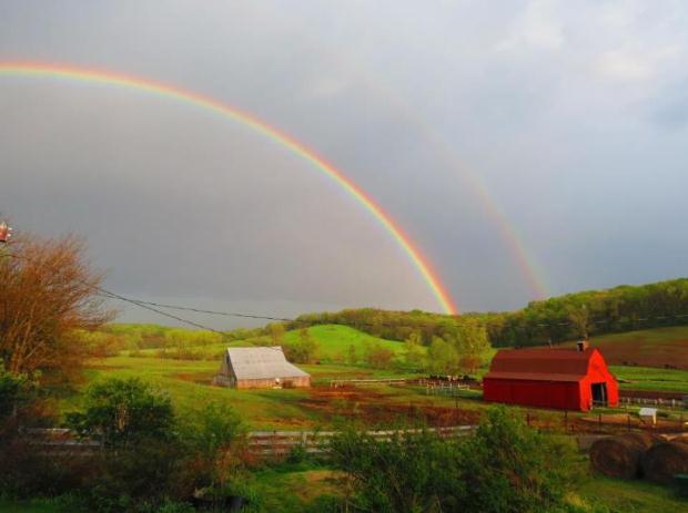
A Very Soggy June. There's a good reason the drought
is history across most of Minnesota. June rainfall was more than twice
the normal amount for many towns. Here's an excerpt from Mark Seeley
at
Minnesota WeatherTalk: "...
Like
previous months this year, June turned out to be wetter than normal
for most Minnesota observers. Exceptions were some areas of northern
Minnesota which received less than normal rainfall for June. For some
Minnesota communities it was a very wet month indeed. Among those
reporting over 9 inches for the month were Morris, Albert Lea, Wells,
Caledonia, Preston, and Spring Grove. The June rainfall of 12.13 inches
at Spring Grove is a new record total for the month surpassing 11.70
inches in 2000, while the 12.58 inches reported from Wells, MN is also
a new June record for them..." (photo: Marlo Lundy).
Hurricane Guide: Predicting Storm Intensity Remains At Elusive Challenge For Meteorologists. Here's an excerpt from an excellent article at
al.com: "...
Yet,
forecasting storm intensity remains a more elusive challenge. That’s
why you see so much leeway in the number of major storms predicted,
Williams said. “It’s a real problem.” The factors that determine how
strong a storm will be and where it will make landfall rests on shaky
science. And the years between major storms offers a premature glimpse
into storm outlook for the season. “Historically, every 10 years or so
we’ve had a major storm,” said Jeff Garmon, meteorologist with the
National Weather Service in Mobile. “Unfortunately, nature is not as
predictable as that.” Weather experts look to a number of ingredients
that combine to make an intense tropical storm..."
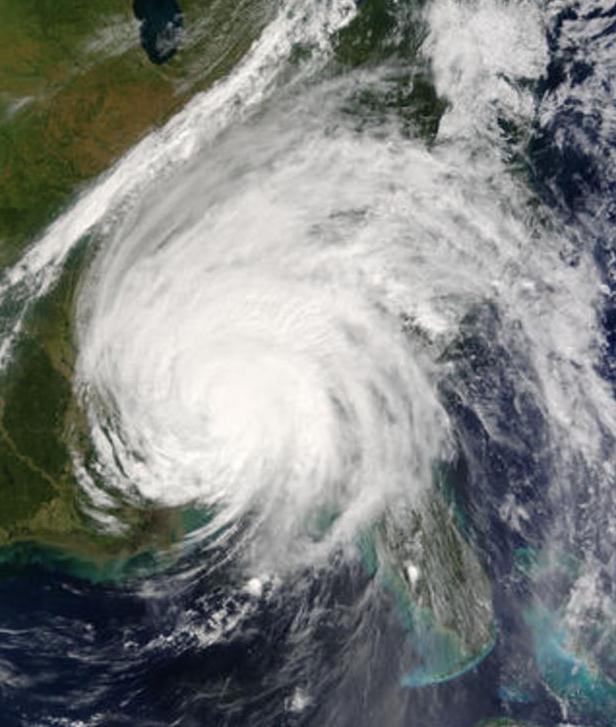
Image credit above: "
Hurricane Ivan makes land fall on the Gulf Coast in 2004." (Photo Courtesy of NASA Scientific Visualization Studio)
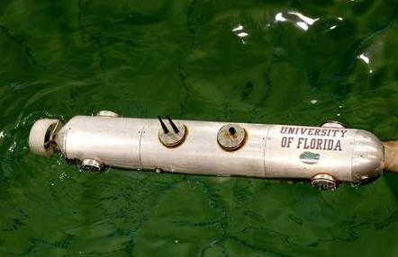
University of Florida Devices May Change How Storms Are Tracked.
Remotely controlled weather drones to (more safely) monitor and track
tornadoes and hurricanes? Seems like a logical evolutionary step to me.
Here's a clip from a very interesting article at
gainesville.com: "...
Kamran
Mohseni, a UF engineering professor, and his team are developing
miniature airplanes and small submarines with sensors that track
pressure, temperature, humidity and other measurements. Sent by the
dozens into the storm, Mohseni said the many small vehicles working
together can obtain accurate information from many different
environmental situations. Now others, including many in the military,
favor large do-it-all devices that gather information from inside the
storm, Mohseni said. While the idea sounds reminiscent of the 1996 movie
“Twister,” it's more complex..."
Image credit above: "
The Cephelobot, a autonomous
underwater vehicle, floats in a large tank while undergoing tests at
the University of Florida on Tuesday June 25, 2013 in Gainesville. The
submarine is a prototype that will be launched into the ocean under
hurricanes and send back weather data."
Matt
Stamey/Gainesville.com Staff photographer.
Has TV Weather Coverage Become Too Dangerous? Short answer. Yes. Here's an excerpt from
kten.com: "
The
newest extreme sport: covering the weather for TV. In an effort to
satisfy the public's appetite for footage of blizzards, hurricanes and,
most recently, the devastating tornadoes in Oklahoma, reporters as
well as professional and amateur chasers are heading straight into the
eyes of the storms. After Tim Samaras, Paul Samaras and Carl Young, the stars of Discovery's Storm Chasers series, died
while filming the El Reno, Oklahoma, tornado on May 31, some in the
industry are wondering if the competition to get the scariest shot has
gone too far. Weather Channel meteorologist Mike Bettes
thinks so. While following the same twister, his car was lifted off
the ground and dumped 325 feet away. "This is a wake-up call about the
safety of people chasing weather," says Bettes, who suffered cuts from
broken glass (his cameraman cracked a vertebrae in his neck)..."
After Storm Deaths, Search On For Perfect Warning.
Can too much lead time for a tornado warning be just as dangerous as not
enough? It may sound counterintuitive, but if there's more than 20-30
minutes warning lead time it may tempt (some) people to try to outrun a
tornado, or take video of the approaching storm. Details in this clip
from AP and
Weatherbug.com: "...
Some
experts, though, acknowledge there is debate about whether there can
be too much advance warning of tornado strike, and if this could lead
people to take foolish risks such as trying to dart across town to
pick up a loved one or taking to the open road to try to outrun a
violent storm."There's a great philosophical discussion about what
constitutes the ideal lead time," said Greg Carbin, a warning
coordination meteorologist for the National Weather Service's Storm
Prediction Center in Norman, Okla. "The more lead time the better, but
the flip side of that is that accuracy and certainty in our
predictions usually decrease with lead time." Over the last five years,
residents in the U.S. have been given an average lead time of 13
minutes between the issuance of a tornado warning and a confirmed
tornado on the ground. That's a 17-minute increase from the 1980s,
when tornado warnings were typically issued four minutes after a
funnel had been spotted, said Lans Rothfus, who is deputy chief of the
warning research and development division at the National Severe
Storms Laboratory in Norman..."
Tips For Surviving A Mega-Disaster. Not something
any of us want to consider - at least we don't have to worry about
tsunamis in Minnesota; one of the few natural disasters we don't have to
lose sleep over. Here's an excerpt of an interesting article at
Northeast Indiana Public Radio: "...
The
nation has done a good job preparing for natural disasters like
hurricanes and tornadoes, which occur frequently but usually produce
limited damage and relatively few casualties, the panelists said. But
government officials are just beginning to develop plans for events like
a major tsunami or a large asteroid hurtling toward a populated area.
The difference between a disaster and a mega-disaster is scope, the
scientists say. For example, Hurricane Sandy was defined as a disaster
because it caused significant flooding in New York and New Jersey last
year, says Lucy Jones
of the U.S. Geological Survey. But the flooding was nothing like what
happened to California in the winter of 1861 and 1862, she says..." (Image: Oregon State).
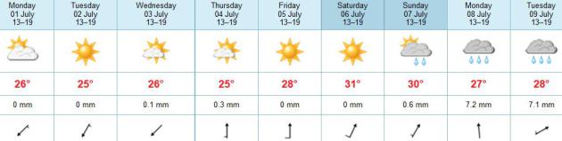
TODAY: Sunny & beautiful. Dew point: 54 Winds: NE 8. High: 82
MONDAY NIGHT: Clear, still comfortably cool. Low: 58
TUESDAY: Plenty of sun, light winds. High: 81
WEDNESDAY: Blue sky holding pattern. Wake-up: 59. High: 81
4TH OF JULY: Partly sunny, dry across most of Minnesota. Isolated late PM T-shower southern MN. Wake-up: 62. High: 83
FRIDAY: Partly sunny, more humid. Dew point: 65. Wake-up: 65. High: 86
SATURDAY: Hot sun, T-storms far north. Wake-up: 70. High: near 90
SUNDAY: Steamy. More numerous T-storms. DP: 70. Wake-up: 72. High: 87
Climate Stories...
Climate Change Blamed For Increasing Allergy Problems. Here's a snippet of a story from
The Courier Journal: "...
A
federal plant physiologist says tree pollen is emerging roughly two
weeks sooner in the spring, and ragweed pollen is lingering two to
four weeks longer in the fall. In fact, pollen counts are expected to
more than double by 2040, according to a study presented at a meeting
of the American College of Allergy, Asthma and Immunology last fall.
“The more pollution, the more global warming, we’re definitely seeing
higher pollen counts,” said Dr. David Pallares of Louisville Allergy
and Asthma. “Over the last decade, there has been a progressive
increase in pollen counts compared with in the past....”
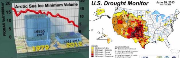
Scientists Predicted A Decade Ago Arctic Ice Loss Would Worsen Western Droughts. Is That Happening Already? Here's a Joe Romm post at
Think Progress: "
Scientists
predicted a decade ago that Arctic ice loss would bring on worse
western droughts. Arctic ice loss has been much faster than the
researchers — and indeed all climate modelers — expected (see “CryoSat-2 Confirms Sea Ice Volume Has Collapsed“).
It just so happens that the western U.S. is in the grip of a brutal,
record-breaking drought. Is this just an amazing coincidence — or were
the scientists right and what would that mean for the future? I ask the
authors. Here is the latest drought monitor (above right)..."
Humans: The Real Threat To Life on Earth. There's a
headline that's bound to get attention (and not all positive). But it's a
compelling argument - one I hope the author ultimately gets wrong,
Population growth is a very real concern, one that has a domino effect
on all other problems. Some of the statistics in the
Huffington Post
article are worth the read (how much water it takes to ultimately make a
burger, or a lousy cup of coffee, how much water is required to make a
plastic bottle that holds...water, to name just a couple. Some of the
energy statistics are even more eye-opening. Here's an excerpt: "...
We
hear the term "climate" every day, so it is worth thinking about what
we actually mean by it. Obviously, "climate" is not the same as
weather. The climate is one of the Earth's fundamental life support
systems, one that determines whether or not we humans are able to live
on this planet. It is generated by four components: the atmosphere (the
air we breathe); the hydrosphere (the planet's water); the cryosphere
(the ice sheets and glaciers); the biosphere (the planet's plants and
animals). By now, our activities had started to modify every one of
these components. Our emissions of CO2 modify our atmosphere. Our
increasing water use had started to modify our hydrosphere. Rising
atmospheric and sea-surface temperature had started to modify the
cryosphere, most notably in the unexpected shrinking of the Arctic and
Greenland ice sheets. Our increasing use of land, for agriculture,
cities, roads, mining – as well as all the pollution we were creating –
had started to modify our biosphere. Or, to put it another way: we had
started to change our climate..."
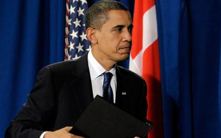
Obama Asks Americans To Declare They Won't Vote For Those Who Don't Act On Climate Change. Here's a clip from
The Washington Post: “...
If
you agree with me, I’ll need you to act,” Obama says, appealing to
Americans to spread the word to their family, friends and classmates.
“Remind everyone who represents you, at every level of government, that
there is no contradiction between a sound environment and a strong
economy — and that sheltering future generations against the ravages of
climate change is a prerequisite for your vote.” Obama’s remarks in
his weekly radio and Internet address, released Saturday but recorded
at the White House prior to the start of Obama’s weeklong trip to
Africa, marks the start of a new phase for Obama’s efforts on climate
change: convincing the public to sell it for him..." (Photo: AP).


No comments:
Post a Comment