86 F. high in the Twin Cities Sunday.
84 F. average high on July 14.
91 F. high on July 14, 2012.
7 days at or above 90F in the Twin Cities (as of today).
20 days at or above 90F as of July 15, 2012.
Best Kept Secret
In a recent CNBC poll (highlighted below) Minnesota
finished 3rd for "Quality of Life", behind Hawaii and Vermont. Hawaii I
get, but Vermont? No treat in January either, unless you're a skier or
lumberjack.
The old adage that "Minnesota is the toughest
state to get Fortune 500 executives to move to, and the hardest to get
them to leave" rings true.
When I moved here in '83 I couldn't understand
why people were driving 2-4 hours to their cabins, when there were lakes
in the metro. I get it now, and it's probably a back-handed blessing
most of America is clueless about what's up here.
I haven't seen lake levels this high in 20
years; part of my yard washed into the street during Saturday's tropical
torrent. As downpours increase in frequency we'll all be looking for
new ways to make our homes & yards more resilient and storm-proof.
No drama this week, God-willing.
Expect highs above 90F into Thursday, late week
storms - then a slight dip in dew point next weekend. A real cool front
is shaping up for next week.
It's all about perspective right? Last year we
saw 20 days above 90F by July 15. Today will be the 7th day at/above
90F. Atlanta ("Hot-lanta?") has only seen 4 days above 90F in 2013!
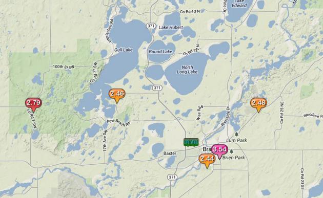
Flooding Rains In Brainerd Area Sunday Morning. The
same warm front that spawned 3-8" rains from the west metro into
southern Minnesota early Saturday sparked copious rains yesterday, 3.54"
at the airport in Brainerd, 2.45" on Gull Lake, most of that in less
than 2 hours.
One Of The Hotter Weeks of Summer. The hottest?
Possibly, although I can't predict that with a high degree of
confidence. Highs should nudge 90F today, and climb into the 90s Tuesday
and Wednesday. Metro highs may hit 90F again Sunday before a
significant cooling trend next week. Free A/C is about 1 week away,
based on ECMWF guidance.
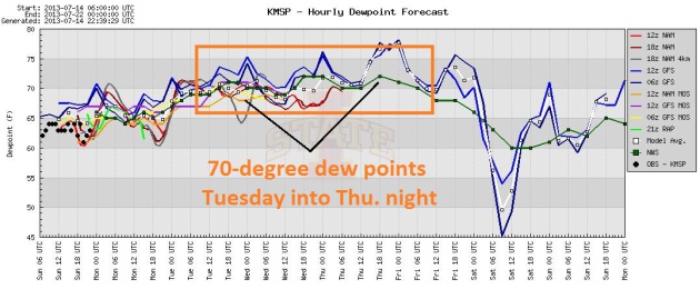
Dew Point Blues. Dew points are forecast to hit 70
by Tuesday, and hold fairly steady into Thursday before dropping off to
more tolerable levels by the weekend. Graphic: Iowa State.
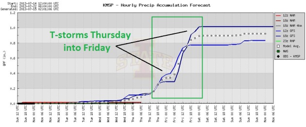
A Dry Stretch. Odds favor a dry sky into Thursday
morning; the approach of (slightly) cooler, drier air setting off a few
T-storms late Thursday into Friday, then drying out for next weekend. In
theory. We'll see.
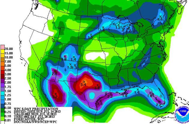
A Sloppy Week For Texas. Most of the rain predicted
the next 5 days for Minnesota comes today up north, another round of
T-storms by late week. The heaviest rains this week fall on Texas, some
3-5" amounts from near Dallas to Austin and Midland, while the west
coast remains tinder-dry. The tropics are quiet, for now.
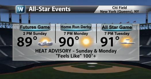 A Steamy All-Star Game
.
Temperatures Tuesday evening at Citi Field in New York City should
still be in the low 90s for the first pitch of this year's All Star
Game. Graphic: WeatherNation TV.
Prepare Your Home And Finances For A Natural Disaster. There's some very good advice in this article at
The Wall Street Journal; here's an excerpt: "
You
may not be as prepared as you think. When a storm is bearing down or a
wildfire or tornado is approaching, you don't want to be thinking about
all the things you should have done to protect your family, house and
finances. So with wildfires raging in parts of the West, and hurricane
season in full swing, taking some crucial steps in advance—especially
if you live in a region prone to natural disasters—can help you
minimize any damage. "It's imperative to make sure you are prepared,"
says Thomas Kirsch, a member of the American Red Cross Scientific
Advisory Council and co-director of the Center for Refugee and Disaster
Response at Johns Hopkins University. "Get things ready to go," he
says, with a disaster kit "and the appropriate financial stuff
available to you..."
How Many Bathtubs Worth of Rain? 4" of rain on an
acre of land translates into 108, 616 gallons of water. If anyone asks.
Which is doubtful. A few statistics to try and put Saturday morning's
record rains into perspective below.
Putting Excessive Rains Into Perspective. I
estimated a 30 by 30 mile area of the western and southwestern suburbs
picked up 4" or more of rain (it's a WAG, but I think it's in the
ballpark). Yes, you too can calculate how many bathtubs full of water
fell on the metro area, thanks to the
USGS.
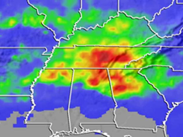
NASA Data Link Pollution To Rainy Summer Days in The Southeast.
Could smog/pollutants from vehicles and industry be seeding the
clouds, sparking more showers and T-storms during the work week, when
there's more traffic and activity in general? Here's a summary of a
2008 report from
NASA: "
The
link between rainfall and the day of the week is evident in data from
NASA's Tropical Rainfall Measuring Mission satellite, known as TRMM.
Midweek storms tend to be stronger, drop more rain and span a larger
area across the Southeast compared to calmer and drier weekends. The
findings are from a study led by Thomas Bell, an atmospheric scientist
at NASA’s Goddard Space Flight Center, Greenbelt, Md. Bell said the
trend could be attributed to atmospheric pollution from humans, which
also peaks midweek. "It's eerie to think that we're affecting the
weather," said Bell, lead author of the study published online this
week in the American Geophysical Union's Journal of Geophysical
Research. "It appears that we're making storms more violent." Rainfall
measurements collected from ground-based gauges can vary from one
gauge site to the next because of fickle weather patterns. So, to
identify any kind of significant weekly rainfall trend, Bell and
colleagues looked at the big picture from Earth's orbit. The team
collected data from instruments on the TRMM satellite, which they used
to estimate daily summertime rainfall averages from 1998 to 2005
across the entire Southeast..."
Image credit above: "
Torrential
rainfall from a 2003 storm in the Southeast resulted in massive
accumulations of rain (red). Similar data from NASA's TRMM satellite
has revealed that more rain falls midweek." Credit: NASA.
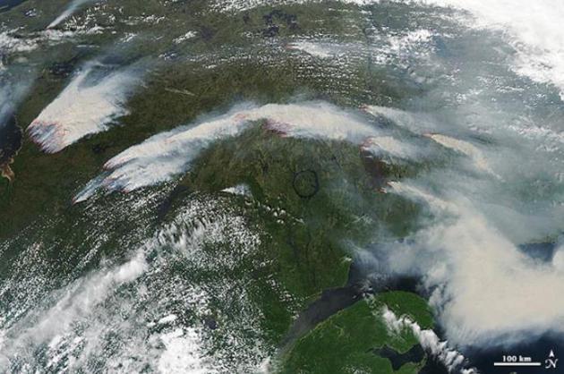
Canada's Second Largest Fire On Record Spreading Smoke To Europe.
Some of that smoke has been circulating back into the USA, making for
hazy (milky) skies and blood-red sunsets in recent weeks. Here's an
excerpt from Dr. Jeff Master's
WunderBlog: "
A
massive fire burning in northern Quebec is Canada's second largest
fire since fire records began in 1959, according to the Canadian Forest
Service. The fire was more than twice the size of Rhode Island on
Tuesday--1,621,000 acres. Called the Eastmain fire, the near-record
blaze was ignited by lightning on May 25, and was burning along a
100-km front near the east shore of James Bay by the village of Eastmain. At times, the fire spread at 19 mph (30 kph). The fire cut power to Montreal's subway system and to 10% of the population of Quebec (500,000 customers) on July 4, when smoke from the fire ionized the air by key hydroelectric power lines, causing a cascade failure..."
Image credit above: "On
July 4, 2013, the Moderate Resolution Imaging Spectroradiometer
(MODIS) on NASA’s Aqua satellite captured this image of wildfires
burning in western Quebec near James Bay. Red outlines indicate hot
spots where MODIS detected unusually warm surface temperatures
associated with fire. The Eastmain fire, which became the 2nd largest
fire since 1959 in Canada at 1.6 million acres, is at the upper left of
the image, just east of James Bay. Other fires near Nemiscau, Quebec
(about 150 - 200 km to the southeast of Eastmain) are also burning,
but these patches are "only" 120,000 - 200,000 acres. MODIS also
observed smoke from the fires moving across the Atlantic Ocean on July
5, July 6, and July 7. By July 8, smoke was drifting over Scandinavia." Image credit: NASA.
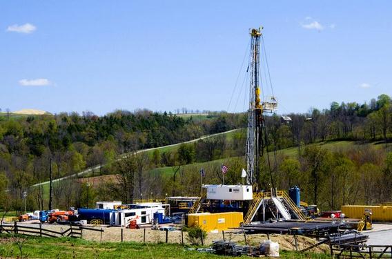
Pumping Water Underground Could Trigger Major Earthquake, Say Scientists. Huge injections of water for "fracking" have already sparked tremors; water apparently lubricating faults deep underground.
The Guardian has more: "
Pumping water underground at geothermal power plants can lead to dangerous earthquakes
even in regions not prone to tremors, according to scientists. They
say that quake risk should be factored into decisions about where to
site geothermal plants and other drilling rigs where water is pumped underground – for example in shale gas fracking.
Prof Emily Brodsky, who led a study of earthquakes at a geothermal
power plant in California, said: "For scientists to make themselves
useful in this field we need to be able to tell operators how many
gallons of water they can pump into the ground in a particular location
and how many earthquakes that will produce..." (File photo: Ralph Wilson, AP).
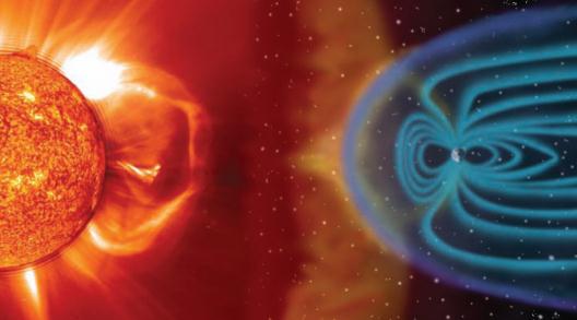
When Space Weather Attacks! Great headline, sobering reading, courtesy of
The Washington Post. Here's an excerp: "...
Today,
electric utilities and the insurance industry are grappling with a
scary possibility. A solar storm on the scale of that in 1859 would
wreak havoc on power grids, pipelines and satellites. In the worst
case, it could leave 20 million to 40 million people in the Northeast
without power — possibly for years — as utilities struggled to replace
thousands of fried transformers stretching from Washington to Boston.
Chaos and riots might ensue. That’s not a lurid sci-fi fantasy. It’s a sober new assessment
by Lloyd’s of London, the world’s oldest insurance market. The report
notes that even a much smaller solar-induced geomagnetic storm in
1989 left 6 million people in Quebec without power for nine hours..."
Image credit above: NASA.
Large Power Transformers And The U.S. Electric Grid.
Light reading this is not, but here is an important document focused
on the U.S. grid and vulnerabilities to space weather, as well as other
factors, courtesy of the
U.S. Department of Energy.
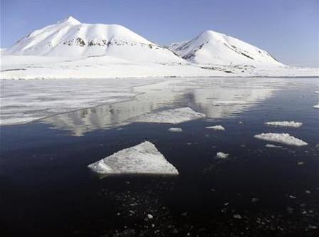
America's Top States For Quality Of Life. I love the photo
CNBC
used for Minnesota, taken sometime in January? Good grief. In spite of
our well publicized winters we still came in at #3 overall, just
behind Vermont and Hawaii. I get Hawaii, but Vermont....really? Here's
an excerpt: "
The North Star State has something to offer almost
everyone. Enjoy the natural beauty of the North Woods or the
cosmopolitan sophistication of the Twin Cities. And everyone, it seems,
is "Minnesota Nice" - so much so that the crime rate is among the
nation's lowest. The home of the famed Mayo Clinic is one of America's
healthiest states, and the environment is among the cleanest. But if
you're not a fan of winter, beware. With an average annual temperature
of just 41.2 degrees F, Minnesota is one of America's coldest states.
But they'll tell you - nicely - that they know how to adapt...."
2013 Quality of Life Rank (Points): #3
2013 Overall Rank: #15
2012 Quality of Life Rank: #5
TODAY: Hot sun. Winds: South 10. Dew point: 68. High: 90
MONDAY NIGHT: Clear and warm. Low: 74
TUESDAY: Sunny, even hotter. Dew point: 71. High: 93
WEDNESDAY: Sticky sun, a 2 shower day. DP: 71. Wake-up: 76. High: 94
THURSDAY: Muggy, few T-storms bubble up. Dew point: 72. Wake-up: 75. High: 91
FRIDAY: Early storm, turning less humid. Dew point: 67. Wake-up: 72. High: 85
SATURDAY: Metro sun, few PM storms up north. Dew point: 68. Wake-up: 70. High: 87
SUNDAY: Good day for the lake. Plenty of sunshine. Dew point: 68. Wake-up: 68. High: 89
Climate Stories...
Seas May Rise 2.3 Meters Per Degree (C) Of Global Warming: Report. Here's the intro to a story from
World Bulletin: "
Sea
levels could rise by 2.3 metres for each degree Celsius that global
temperatures increase and they will remain high for centuries to come,
according to a new study by the leading climate research institute,
released on Monday. Anders Levermann said his study for the Potsdam
Institute for Climate Impact Research was the first to examine evidence
from climate history and combine it with computer simulations of
contributing factors to long-term sea-level increases: thermal
expansion of oceans, the melting of mountain glaciers and the melting
of the Greenland and Antarctic ice sheets..."
Climate Change Will Cause More Energy Breakdowns, U.S. Warns.
The New York Times has the story - here's an excerpt: "...
The blackouts and other energy disruptions
of Hurricane Sandy were just a foretaste, the report says. Every
corner of the country’s energy infrastructure — oil wells,
hydroelectric dams, nuclear power plants — will be stressed in coming
years by more intense storms, rising seas, higher temperatures and
more frequent droughts. The effects are already being felt, the report
says. Power plants are shutting down or reducing output because of a
shortage of cooling water. Barges carrying coal and oil are being
delayed by low water levels in major waterways. Floods and storm surges
are inundating ports, refineries, pipelines and rail yards. Powerful
windstorms and raging wildfires are felling transformers and
transmission lines..."
Climate Change Will Plague Energy Industry: DOE. Following up on the story above, here's a slightly different perspective from
CBS Marketwatch: "
Climate
change has created problems for the U.S. energy industry, and the
stress it brings on an aging energy infrastructure could cancel out the
coping mechanisms the industry has adopted, a Department of Energy
report released Thursday said. The report
highlighted the implications of climate change — droughts, fiercer
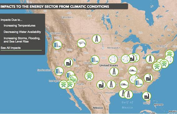
storms, flooding, and higher temperatures, to name a few — on energy. An interactive map,
showing where impact has already occurred, accompanied the report.
Droughts have raised the risk of shutdowns at power plants powered by
coal, natural gas, and nuclear energy by reducing the volume of water
available for cooling the plants..."





No comments:
Post a Comment