90 F. high in the Twin Cities Tuesday.
80 F. average high on August 20.
79 F. high on August 20, 2012.
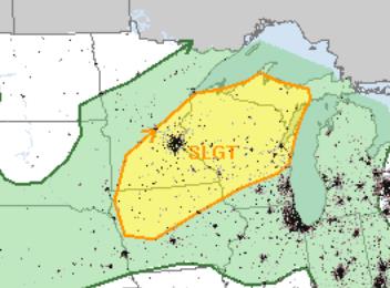
Slight severe storm risk today.
4-6 more days above 90F between today and September 4?
Super-Sized Summer
It all makes sense, in a baffling,
passive-aggressive way. There was grumbling over snow in early May,
muttering about an "abbreviated summer", one notable heat spike in early
July, then 4 weeks of September-like chill into August, a rare
mid-summer frost up in Embarrass.
Many people had mentally turned the page,
convinced we were sliding inexorably into autumn. "The antithesis of
2012" a friend sighed.
Now that neon-yellow school buses are showing up
on Doppler and mom's shopping for winter clothing bargains, now it
decides to heat up. Now we get the weather we should have seen in July.
More evidence that a manic Mother Nature needs to be medicated - we just keep flailing from one crazy extreme to the next.
The bloated heat bubble that has left much of
the western USA drought-stricken and combustible will expand east,
pulses of extreme heat lapping into Minnesota over the next 2 weeks, in
fact some models show 90s spilling over into the first week of
September.
100F next week? We can't rule it out, mainly over southwest Minnesota.
A brief surge of comfortable air may set off a
few strong/severe storms by evening but today's weather mantra is easy
to remember.
Stinking.
Hot.
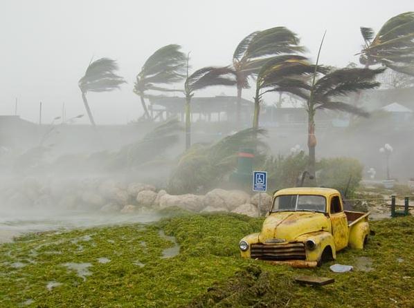
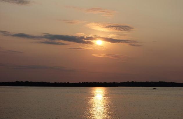
* photo above from yesterday's sunset, a
hazy/milky sky and cherry-red sign tip-offs of smoke from Canadian
forest fires sweeping south into Minnesota.
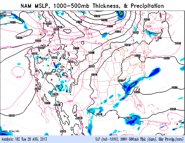
Slight Severe Storm Risk. The approach of cooler,
much less humid air may destabilize the atmosphere enough for a squall
line to form by afternoon, an outside chance of a few severe storms,
especially south/east of MSP after 2 PM. Map: NOAA SPC.
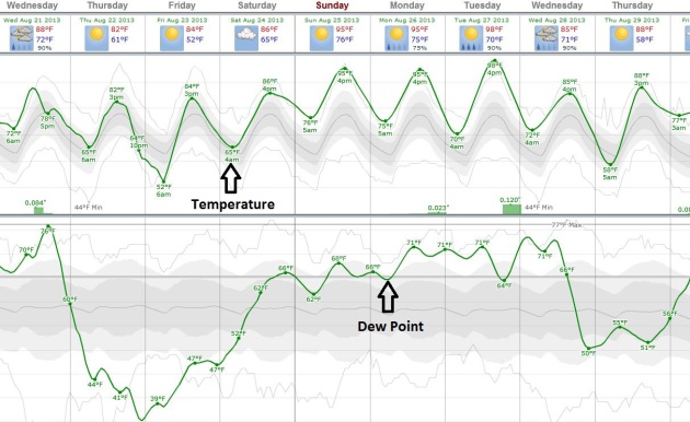
One Wild Meteorological Ride. Dew points are
forecast (by ECMWF guidance) to drop into the 40s Thursday, less than
half as much water in the air as this morning. And then dew points
return to near 70 by early next week as another pulse of heat surges
north. Guidance shows mid-90s Sunday and Monday, a high of 98F on
Tuesday? We'll see, but the model trends are pretty apparent at this
point. Graph: Weatherspark.com.
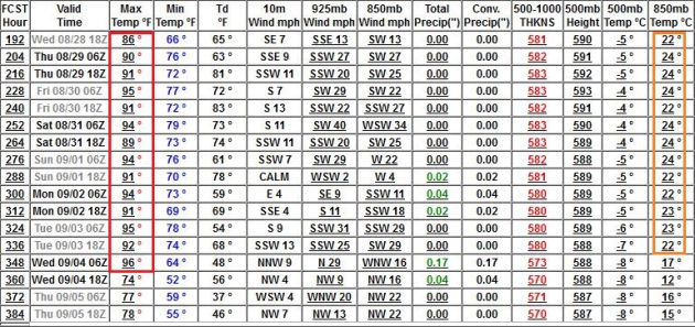
Dog Days of Early September. GFS guidance shows more
90-degree days from late next week into the first few days of
September. Yes, it may be a sizzling Labor Day holiday weekend.
Temporary Relief Northern USA - Hurricane Potential For Cabo? The
NAM model shows a line of strong/severe storms popping over Wisconsin
and southeast Minnesota later today, cooler air pushing into New England
by Thursday. The tropics remain quiet, except for coastal Mexico - a
potential for a tropical storm or hurricane approaching Cabo San Lucas
by Friday.
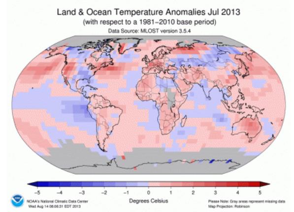
July: 6th Warmest On Record Worldwide. Here's an excerpt from a full report on July 2013 from
NOAA NCDC: "
According
to NOAA scientists, the globally averaged temperature for July 2013
was the sixth highest July since record keeping began in 1880. It also
marked the 37th consecutive July and 341st consecutive month (more than
28 years) with a globally averaged temperature above the 20th century
average. The last below-average July temperature was July 1976 and the
last below-average temperature for any month was February 1985. Many
areas of the world experienced much warmer-than-average monthly
temperatures, including northern South America, the western and
northeastern United States, much of Africa, western and central Europe,
parts of southern Asia, and most of Australia. Parts of the central and
southeastern United States, small regions across northern Canada,
eastern Greenland, and parts of Mongolia and eastern Siberia were cooler
than average. Far northwestern Canada and part of the eastern United
States were much cooler than their long-term averages..."
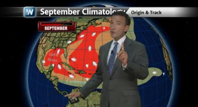
Quiet In The Atlantic, But For How Long? We've had 5
puny, fizzling tropical storms. The knee-jerk reaction might be to
dismiss the rest of hurricane season, to lower your guard, but that
would probably be premature. The peak of hurricane season is September
10, the date when a hurricane landfall is most likely on the U.S. coast,
coinciding with peak water temperatures in the Atlantic and Caribbean.
In today's edition of
Climate Matters we examine why we have yet to see a hurricane in the Atlantic, and what may be in store the rest of 2013: "
We
have already had 5 named storms in the Atlantic, but zero hurricanes.
How does this compare to years past? And could predictions for a busy
tropical season still pan out? WeatherNation Chief Meteorologist Paul
Douglas looks at the factors that have contributed to a quiet season so
far and what could be in store as we approach the typical season peak."
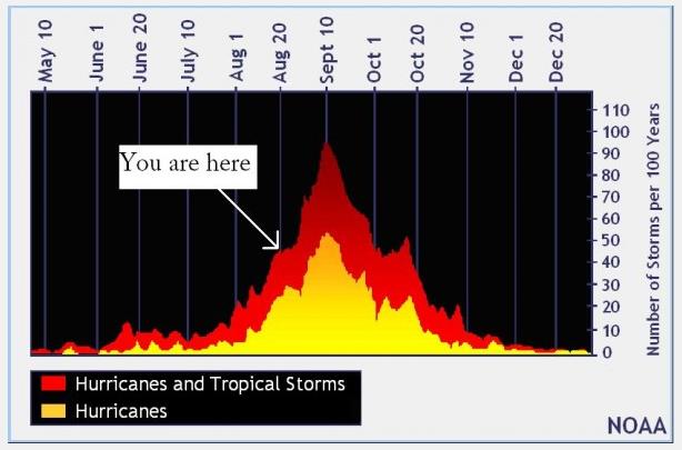
Uh Oh. Is The Hurricane Season Forecast A Bust? Here are some good points from Eric Berger at
The Houston Chronicle: "
As you may recall, back in June,
nearly every seasonal hurricane forecaster under the sun predicted a
busy season. NOAA even predicted a possibly “hyper-active” season. Since
we’re now approaching the peak of the Atlantic hurricane season, and
such hyperactivity has yet to materialize, a number of readers have
asked whether such seasonal forecasts might be considered a bust. My
answer: Not yet. Herein I explain why.
ACTIVITY TO DATE
So far there have been five named storms in the Atlantic basin
this season, which is in fact ahead of what we normally would expect.
During a typical Atlantic season the fifth named storm doesn’t form until Aug. 31. This would suggest prognostications of a busy season have come to pass...."
Graphic credit above: "
The traditional peak of hurricane season is still three weeks away." (NOAA)
NOAA: "70% Chance Of Above-Normal Hurricane Season". Here's an excerpt from a post at
NOAA's Climate Prediction Center: "
NOAA's
updated 2013 Atlantic Hurricane Season Outlook continues to call for an
above-normal season, with the possibility that the season could be very
active. The outlook indicates a 70% chance of an above-normal season, a
25% chance of a near-normal season, and only a 5% chance for a
below-normal season....Based on the current and expected conditions,
combined with model forecasts, we estimate a 70% probability for each of
the following ranges of activity for the entire 2013 Atlantic hurricane
season:
* 13-19 Named Storms.
* 6-9 Hurricanes
* 3-5 Major Hurricanes (Category 3 or stronger)
* Accumulated Cyclone Energy (ACE) range of 120% - 190% of the median...."
File Photo above: Mike Theiss, National Geographic.
Hurricane Season: Forecasters Predict Rise In Activity. Here's a clip from
delmarvanow.com: "
With
the peak of the mid-Atlantic hurricane season underway, forecasters at
the National Climate Prediction Center said we can expect an active
hurricane season over the next few months, although slightly less
intense than initially expected. The revised estimate calls for 13 to 19
named storms, which is down from the 13 to 20 storms forecast in May by
the center. The bad news for the Mid-Atlantic: two of four named
storms that have formed this season did so in the warm, open waters of
the Atlantic Ocean off the coast of Africa – the region that produces
some of the worst August and September storms for our region..."
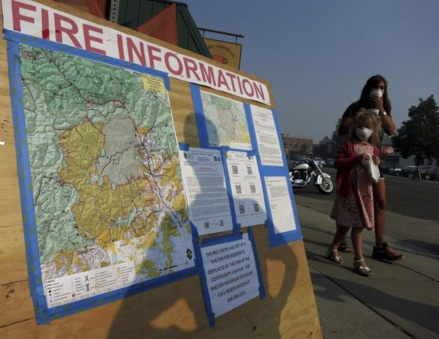
Wildfire Clears Sun Valley Resort Region During Peak Tourist Season. Here's an update on the massive blaze in Idaho from
Skift: "
A
wildfire that has forced the evacuation of more than 2,000 homes in
central Idaho roared largely unchecked into a 12th day on Monday near
the ski resort of Sun Valley,
even though fire crews launched a big offensive against the blaze at
the weekend. Firefighters took advantage of calmer winds and higher
humidity levels on Sunday to attack the flames aggressively, but still
ended the day with containment lines carved around less than 10 percent
of the blaze’s perimeter, fire officials said. The lightning-sparked
fire has been raging since August 7 near Sun Valley and the adjacent
tourist towns of Ketchum and Hailey. It has charred some 101,000 acres
of parched sagebrush, grasslands and pine forests in the Sawtooth
National Forest..."
Photo credit above: "
A map of the fire outside Hailey, Idaho." Jim Urquhart / Reuters.
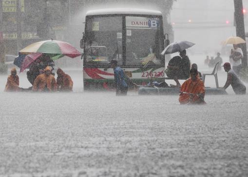
Floods Recede In Philippine Capital As Thousands Evacuate.
Ironically Typhoon "Trami" passed well to the north of the island of
Luzon, yet it moved slowly, fueling heavy rain squalls and T-storms that
stalled out over Manila, dropping nearly a month's worth of rain on
Sunday (23"). The result: widespread flooding and chaos, as reported by
CBC News: "
Flooding
caused by some of the Philippines' heaviest rains that submerged more
than half the capital began receding Tuesday even as authorities
evacuated thousands of residents along Manila's overflowing rivers and
braced for more chaos in outlying provinces. At least eight people have
died, including four who drowned north of Manila. The dead included a
five-year-old boy whose house was hit by a concrete wall that
collapsed, and a three-year-old boy who fell into a swollen river in
Mariveles town in Bataan province. Four people are missing. Throughout
the sprawling, low-lying capital region of 12 million people, offices,
banks and schools were closed and most roads were impassable. People
stumbled through waist- or neck-deep waters, holding on to ropes strung
from flooded houses..."
Photo credit above: "
Office workers cross a flooded street
using makeshift floats during heavy rain at the financial district of
Makati, south of Manila, Philippines on Tuesday, Aug. 20, 2013.
Flooding caused by some of the Philippines' heaviest rains on record
submerged more than half the capital Tuesday, turning roads into rivers
and trapping tens of thousands of people in homes and shelters. The
government suspended all work except rescues and disaster response for a
second day." (AP Photo/Aaron Favila)
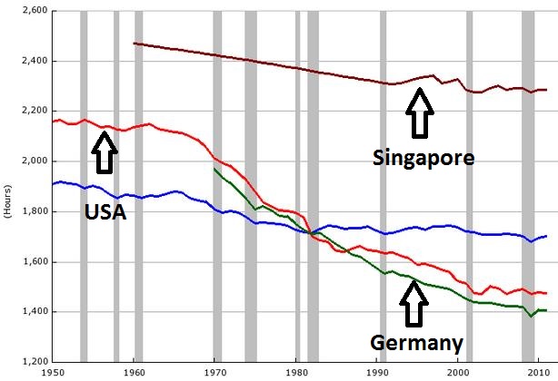
Think You Work Too Much? Be Glad You Don't Live In Singapore. Here's a clip from a fascinating article at
Business Insider. I'm starting to feel better about the number of hours I clock in every week: "
How much work does the average American do each year compared to workers elsewhere in the world? The economics website FRED just added a bunch of new economic data
which makes this question very easy to examine. As you can see, the
average full-time American employee works right around 1,700 hours per
year..."
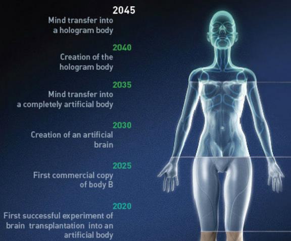
The Immortality Financiers: The Billionaires Who Want To Live Forever.
If you could live indefinitely, would you? I'd consider it if it
included free cable TV (and no bills after the age of 150). Here's a
clip from a fascinating story at
The Daily Beast: "
Of
all the things money can’t buy—love, happiness, time
machines—immortality is one we sure pay a lot for. According to the
market-research firm Global Industry Analysts, the anti-aging industry
generates more than $80 billion per year. All this despite the fact that
there are no proven ways of extending human lifespan. In the past
decade, longevity research has become a legitimate academic pursuit for
molecular biologists. Scientists are trying to untangle the basic
mechanisms that underlie aging, and the idea is catching on that
growing old isn’t just a fact of life but rather a disease that can be
cured through medical interventions. Some of the biggest proponents of
radical life extension also happen to be billionaires. There’s something
about amassing more money than you can ever possibly use that
naturally makes you hunger for ways to stay alive longer—if not forever..." (image above:
discovery.com).
CBS, Time Warner Cable, And The Disruption Of TV.
With online access and multiple new sources of content, television is
going through a disruptive phase - it's anyone's guess what comes out
the other end. Here's a clip from a very good Ken Auletta article at
The New Yorker: "...
What
we’re witnessing are not the deliberate, calculated moves of two
skilled chess players but, rather, two aging players who fear that
their game is being disrupted. Thirty years ago, the traditional TV
world was blindsided by cable; today, cable operators and traditional TV
are both being blindsided by a new crop of technologies. The list of
these technologies is long. You can subscribe to one of two
direct-broadcast satellite systems, DirecTV or Dish Network. You can
get TV along with a speedy Internet connection through Verizon’s FiOS.
A.T. & T. also buys some programming. You can download or stream
many television programs and movies via Netflix, YouTube, Hulu, Apple,
or Amazon. You can stream shows onto a video-game console. You can hook
up to Google’s Chromecast, a small device that lets you beam content to
your TV screen from other devices..."
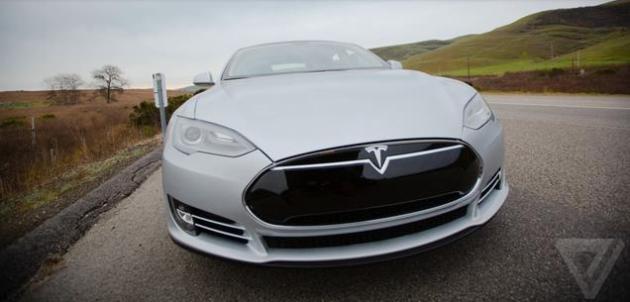
Tesla's Model S Electric Car Nabs Top U.S. Safety Rating. More from
The Verge: "
Tesla is announcing that its Model S
scored top marks for safety according to the National Highway Traffic
Safety Administration (NHTSA), not only scoring a perfect five stars in
every category, but setting a new record for the combined Vehicle
Safety Score (VSS) — a total that can be higher than the five-star
scores for top, side, and rear impact. The Model S scored 5.4, beating
out previous record holders and for the first time making an electric
vehicle the safest car on the road..."
Beers Implicated In Emergency Room Visits. Want to stay out of the ER? Cut down on your beer intake. Here's a clip from an eye-opening article at
The New York Times: "
Nationwide,
roughly a third of all visits to emergency rooms for injuries are
alcohol related. Now a new study suggests that certain beverages may be
more likely to be involved than others. The study, carried out over the
course of a year at the Johns Hopkins Hospital in Baltimore, found
that five beer brands were consumed most often by people who ended up
in the emergency room. They were Budweiser, Steel Reserve, Colt 45, Bud
Ice and Bud Light...."
Photo credit:
Tony Cenicola/The New York Times.
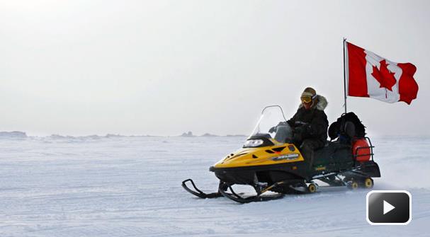
A $620,000 "Stealth" Snowmobile? All electric - able to silently evade the bad guys? The Canadian government is looking into just such a sled, as reported by
CBC: "
The
Canadian military has been secretly test-driving a $620,000 stealth
snowmobile in its quest to quietly whisk troops on clandestine
operations in the Arctic. The Canadian Press has learned that soldiers
have taken the new hybrid-electric snowmobile prototype on trial runs
to evaluate features such as speed, noise level, battery endurance and
acceleration. The Department of National Defence even has a nickname for
its cutting-edge, covert tool: "Loki," after the "mythological Norse
shape-shifting god."
TODAY: Hot sun AM hours, PM storms, a few may be strong to severe? Dew point: 70. High: 92
WEDNESDAY NIGHT: Breezy, turning less humid. Low: 64
THURSDAY: Blue sky, much less humid. Dew point: 45. High: 82
FRIDAY: Sunny, still pleasant. DP: 52. Wake-up: 61. High: 84
SATURDAY: AM storms (best chance central and north). Sticky PM sun. Wake-up: 68. High: 88
SUNDAY: Steamy sun. Late-day T-storms. Wake-up: 72. High: 94
MONDAY: Some sun, still steamy. Dew point: 70. Wake-up: 71. High: 92
TUESDAY: Hot and sweaty. More like mid-July. Wake-up: 73. High: 94
Climate Stories....
Climate Leaks Are "Misleading" Says IPCC Ahead Of Major Report. Here's an excerpt from a story at the
BBC: "
This
massive tome will be published in four stages over the next year - the
first part, the physical science behind climate change, will be
presented in Stockholm on 26 September. The process of compiling this
report, with several hundred scientists, 195 governments and over 100
non-governmental organisations involved has been particularly leaky,
with at least three confidential drafts being made public in the last year. We've had 1,800 comments on that 15 page document” Jonathan Lynn IPCC.
According to the latest scoop, the scientists are set to say they are
more convinced than ever that global warming is caused by humans. They
will say they are 95% certain that our use of fossil fuels is the main
reason behind the global rise in temperatures since the 1950s..."
Scientists Turn To Melted Ice To Make Climate Change Case.
Bloomberg has an update on the forthcoming IPCC report - here's a snippet: "
A
report from an international scientific team due next month will
probably focus on a range of evidence that the Earth is warming rather
than just changes in air temperature, according to a climate scientist
who has seen drafts of parts of the study. The rate of polar ice
melting, warming of oceans and the steady rise of sea levels all point
to a planet heating up, said Kevin Trenberth, a senior scientist in the
climate analysis section at the National Center for Atmospheric
Research. He’s a reviewer for the forthcoming United Nations climate
report. Some skeptics of man’s contribution to global warming have
pointed to lapses in the rise of average temperatures as proof that the
phenomenon isn’t taking place. Previous studies focused on changes in
air temperature, according to Trenberth, who was the lead author of the
2001 and 2007 UN assessments..." (File photo: World Bulletin).
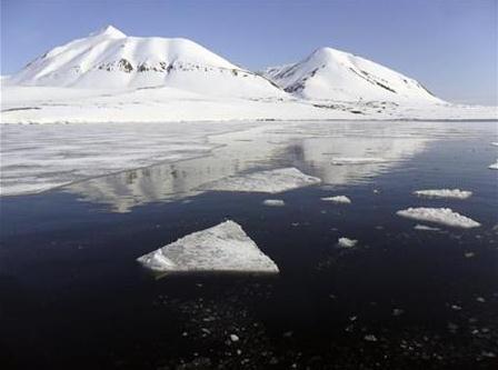
Update On Arctic Sea Ice. Although not as severe as
2012 (which set an all-time record), the decline in Arctic sea ice in
2013 is still significant. Here's an update from NSIDC, the
National Snow and Ice Data Center: "
The
sea ice retreat rate averaged from August 1 to 18 was near average at
approximately 75,000 square kilometers (29,000 square miles) per day.
However, satellite data show extensive low-concentration areas within
the ice cover, which appear to have developed in response to the
frequent passage of storm systems. These weather patterns also result in
lower-than-average air temperatures over the Arctic. Temperatures in
the central Arctic at the 925 hPa level have been 2 to 4 degrees Celsius
(4 to 7 degrees Fahrenheit) below average since late July."
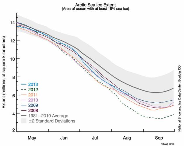
Graphic credit above: "
The graph above shows Arctic sea
ice extent as of August 18, 2013, along with daily ice extent data for
five previous years. 2013 is shown in blue, 2012 in green, 2011 in
orange, 2010 in pink, 2009 in navy, and 2008 in purple. The 1981 to
2010 average is in dark gray. Sea Ice Index data." Credit: National Snow and Ice Data Center
5 Terrifying Statements In The Leaked Climate Report. Here's a clip from a story at
Mother Jones: "...
In particular, here are five "holy crap" statements from the new draft report:
We're on course to change the planet in a way "unprecedented in hundreds to thousands of years." This
is a general statement in the draft report about the consequences of
continued greenhouse gas emissions "at or above current rates."
Unprecedented changes will sweep across planetary systems, ranging from
sea level to the acidification of the ocean.
Ocean acidification is "virtually certain" to increase. Under
all report scenarios, the acidification of the world's oceans will
increase—the draft report calls this outcome "virtually certain." As we
have previously reported,
more acidity "threatens the survival of entire ecosystems from
phytoplankton to coral reefs, and from Antarctic systems reliant on sea
urchins to many human food webs dependent on everything from oysters to
salmon..."
Photo credit above: "
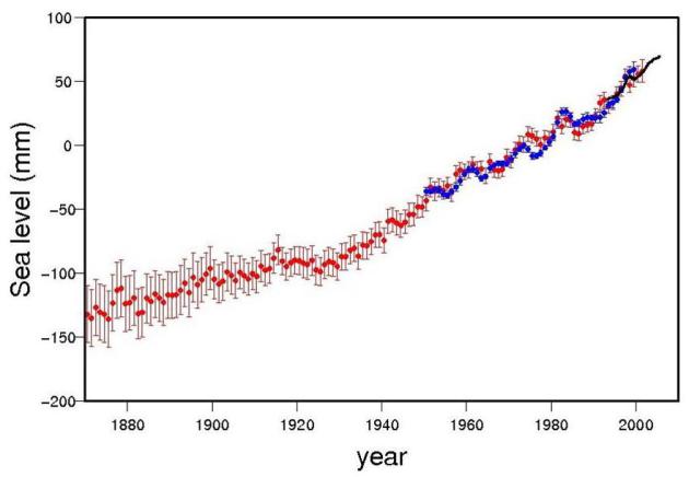
In the long run, global sea level rise could easily exceed 5 meters." Brendan Howard/Shutterstock
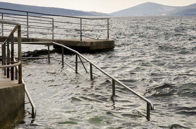
Population Plus Climate: Why Coastal Cities Will Face Increased Risks From Floods. When it comes to the rate of sea level increase we are (literally) in uncharted waters, as pointed out in this article at
Time. Here's a clip: "...
For
coastal cities like New York, Hurricane Sandy was a coming attraction
for what is likely to be a very wet and destructive future. According
to leaked drafts of the forthcoming new report from the Intergovernmental Panel on Climate Change
(IPCC), scientists believe that sea level could rise by more than
three feet by the end of the century is carbon emissions keep growing
at a runaway pace. And a new study
published in the journal Nature Climate Change laid out the enormous
flood losses that major coastal cities could face in the future.
Average global flood losses could rise from approximately $6 billion
per year in 2005 to $60 to $63 billion per year by 2050, thanks to
population and economic growth along the coasts and the multiplying
effect of climate change-driven sea level rise. As Robert Nicholls, a
professor of coastal engineering at the University of Southampton in
Britain and a co-author of the study, put it in a statement: “There is a pressing need to start planning how to manage flood risk now....”
Gorgeous Glimpses Of Calamity. Here's a snippet from
a well-written story about Earth observations from space - we can now
track, in real-time, the impacts we're having on our planet. Details at
The New York Times: "...
President
Obama should invite world leaders to an emergency conclave in
Washington as early as possible and challenge China, India, Brazil,
Indonesia and other major greenhouse-gas emitters to equal or exceed the
percentage reductions he seeks for the United States. He should also
try to rally the nation and globe in support of an international
Manhattan Project, in which the best scientific minds would devise
carbon-sequestration technologies that could clean the air of the
heating elements we’ve put there — rather than simply seeking to limit
the damage. Having constructed a civilization capable of observing our
still paradisiacal world from objectivity-inducing distances, we need
to set aside our squabbles, recognize that we face a species-wide
threat, and use our scientific-technical genius to protect the only
known home of life in the universe."
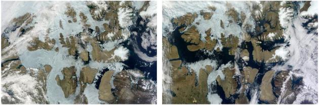
Photo credit above:
July 17 and Aug. 3, 2012: "
Ice
and snow melted with extraordinary speed in the Northwest Passage in
Canada’s Parry Channel, a link in the long-sought northern route for
ship traffic between the Atlantic and Pacific Oceans. Twice in the last
decade, the entire route has become clear of ice. These images were
taken with NASA’s Terra satellite."
Jesse Allen, Lance system/NASA Earth Observatory.
Arctic Warming And Our Extreme Weather: No Clear Link New Study Finds.
Most of the changes we've witnessed (in extremes) have been in the last
3-5 years - it's largely anecdotal and far from conclusive, but I still
suspect rapid warming in the Arctic is having a domino effect at mid
latitudes. Time will tell if science can prove this possible link.
Here's an update on a new research paper from The Washington Post's
Capital Weather Gang: "
Is the dramatic decline of Arctic sea ice,
spurred by manmade global warming, making the weather where we live
more extreme? Several recent studies have made this claim. But a new study
finds little evidence to support the idea that the plummeting Arctic
sea ice has meaningfully changed our weather patterns. The research,
published today in Geophysical Research Letters,
says links between declining Arctic sea ice and extreme weather are “an
artifact of the methodology” and not real. Earlier work, suggesting a
connection between the disintegrating Arctic ice and weather mania in
the mid-latitudes, is intriguing. It is based on the idea that the jet
stream – the river of high altitude winds that steers our storms and
positions cold snaps and heat waves – is slowing down and weakening due
to a pronounced warming in the Arctic compared to other places, a
phenomenon known as Arctic amplification. Rather than zipping right
along a straight path, a more listless jet stream is now prone to
straying so the theory goes..."
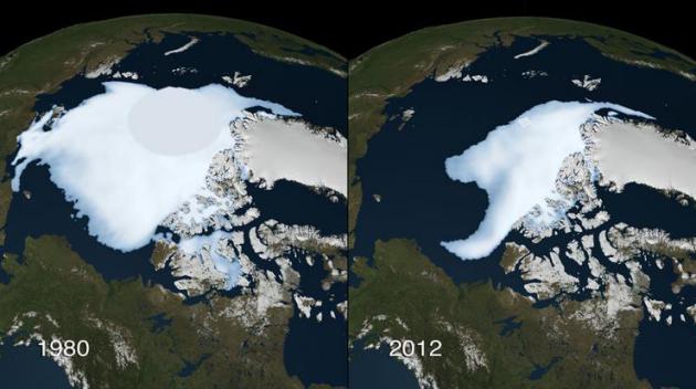
Graphic credit above: "
Arctic sea ice minimum 1980 vs. 2012." (NASA).


No comments:
Post a Comment