2013: 6th warmest year on record, globally, to date.Source: NOAA.
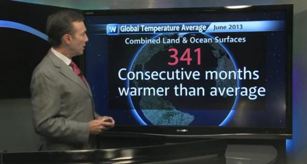
341 July was the 341st consecutive month with global temperatures warmer than the 20th century average.
88 F. high in the Twin Cities Wednesday.
80 F. average high on August 21.
80 F. high on August 21, 2012.
Trace of rain fell at MSP International yesterday.
Late August Heat Wave
Earth continues to run a low-grade fever: July
the 341st month in a row of global temperatures warmer than the 20th
century average. NOAA says it was the 6th warmest July, worldwide, since
1880.
The warming has been anything but uniform. I'm
seeing more random heat "spikes", surges of intense heat and humidity
that come on suddenly.
One such hot front is brewing for next week, and
if ECMWF (European) model guidance can be believed, next week could
wind up being the hottest of the year for much of Minnesota. Yes, very
unusual for late August, considering the sun is now as high in the sky
as it was in late April.
Then again "unusual" is the new normal.
Today will be a breath of fresh (Canadian) air,
dew points dropping into the 40s behind a welcome cool front.
Comfortable weather lingers Friday, but a sticky wave of overheated air
returns Saturday, sparking a few T-storms. By Sunday we may be sizzling
in the mid-90s. Low to mid 90s are predicted for much of next week.
Our on-again, off-again summer will be in high gear; bad news for
schools with no A/C.
For 4 weeks we were stuck under a cool, northwest flow. Next week a heat bubble stalls out directly over Minnesota.
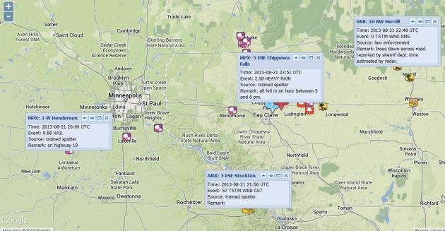
Wednesday Severe Storms. The leading edge of cooler
air set off a squall line over the south metro yesterday afternoon,
reports of 1"+ hail from Henderson to Lakeville to Hastings. Over 2.5"
of rain fell at Chippewa Falls, Wisconsin, with a few reports of funnel
clouds east of Eau Claire. A complete damage report from NOAA
here.
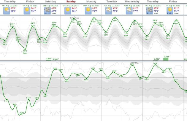
Next Week: Mostly 90s? I'm looking for continuity
from model run to run, but the ECMWF is consistent, showing highs in the
low to mid 90s much of next week. After a 36 hour break in the dew
point department (comfortable 40s today!) expect a dew point near 70 F.
from Saturday afternoon into most of next week. Something to look
forward to. Graph: Weatherspark.com.
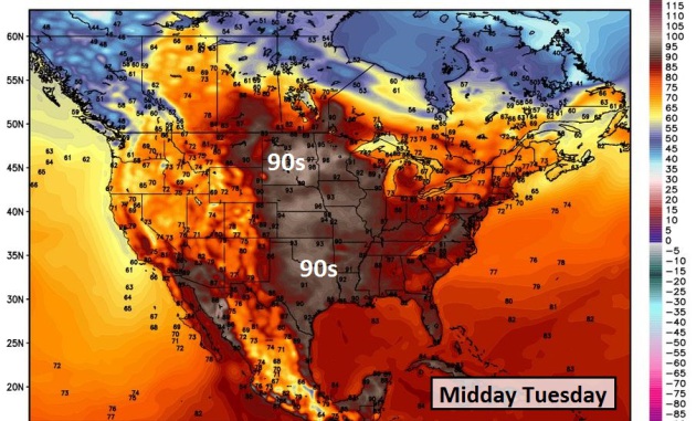
Summer's Coming Late This Year. Yes, we had a spell
of real summer in early July, then a surge of September that lasted the
better part of 4 weeks. Now it's time for Summer, Part 2, starting
Saturday afternoon, extending into next week, with 90s possibly spilling
over into Labor Day. The map above shows predicted highs next Tuesday,
courtesy of WeatherBELL. 100F heat isn't out of the question over the
Dakotas, even far southwest Minnesota.
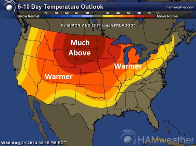
Dog Days of Late August. Here is the latest 6-10 day
temperature outlook from NOAA's Climate Prediction Center, showing a
sizzling bulls-eye over the Northern Plains and Upper Midwest;
temperatures as much as 15-20 F. warmer than average for late August.
Map: Ham Weather.
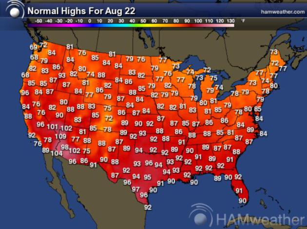
In Search Of Normal. Here is a
Ham Weather map
showing normal highs for August 22. Temperatures over the Upper
Midwest may run as much as 15-20 F. warmer than average from this
weekend into much of next week.
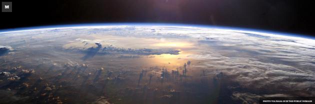
Flashback To February 1985. That's the last time the planet had a cooler than average month. In today's
Climate Matters I take a look at #341, put July (and the year to date) into context: "
Just
how long has it been since the world had a below average month? You
have to go back to February 1985! WeatherNationTV Chief Meteorologist
Paul Douglas goes over the data that made July the 341st consecutive
month above the 20th century average."
Atlantic Basin Primed For An Above-Normal Hurricane Season.
Yes, it's very quiet out there - and we have yet to see our first
hurricane of the season in the Atlantic. Based on a variety of factors
(less Saharan dust, warmer water temperatures, low wind shear) I suspect
September will be a lot busier than August has been. More details from
NOAA's
Climate.gov: "
Andrea, Barry, Chantal, Dorian, Erin*... who’s next? Probably plenty more, according to NOAA’s updated Atlantic hurricane season outlook.
With five named storms already in the books this summer, the 2013
hurricane season is shaping up to be above normal, and there is a
possibility that it could be very active during the peak of the season
from mid-August through October. An additional 9-15 named storms are
likely, of which 6-9 are predicted to become hurricanes, with 3-5
reaching major hurricane status. Among the climate factors behind the
heightened activity? Heat. These maps show the tropical cyclone heat
potential of the tropical Atlantic Ocean ramping up between May 24
(bottom) and August 4 (top). This “hurricane heat potential” depends
not just on the surface temperature, but on the depth of the warm water..."
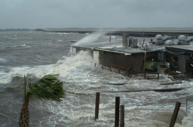
National Hurricane Center Gives Storm Surge Modeling A Major Boost. Here's a clip from an interesting story at The Washington Post's
Capital Weather Gang: "
The
National Hurricane Center (NHC) is running an improved version of its
old, reliable storm surge model on faster computers to help emergency
managers update hurricane evacuation plans. When a storm threatens any
place in the U.S. NHC forecasters will use the improved,
faster-running model to predict its surge. Hurricane forecasters know
those who might be in a hurricane’s path tend to focus on the storm’s
wind speed, which define its one-to-five category. “The categories
put a focus on wind; people are absorbed by wind,” says Jamie Rhome,
the NHC’s storm surge lead, but “water is what kills the vast majority
of people. Evacuations are done for surge...”
Photo credit above: "
Storm surge from Hurricane Dennis in 2005." (USGS)
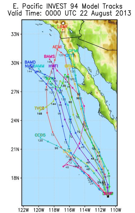
More Active Pattern Eastern Pacific. The map above
shows predicted model tracks for a developing tropical storm off the
coast of Mexico. It should pass west of Cabo San Lucas, and there's a
small, outside chance that some of the moisture from this system could
push into far southern California. Model tracks: University of
Wisconsin.
July: 341st Month/Row Of Warmer Than Average Global Temperatures. Meteorologist Andrew Freedman has the story at
Climate Central; here's a clip: "
The
year-to-date has been the sixth warmest on record globally, and July
was also the sixth warmest such month since global surface temperature
records first began in 1880, according to new data released on Tuesday
by the National Oceanic and Atmospheric Administration (NOAA). The
figures show that July 2013 was the 37th straight July, and the 341st
straight month, with warmer-than-average global temperatures — a more
than 28-year timespan that reflects the significant warming observed
worldwide since the 1970s. That means that no one under the age of 28
has ever experienced a month in which global average surface
temperatures were cooler than average (based on the 20th century
average)..."
Can We Trust Google With The Stratosphere? A
planetwide constellation of nearly stationary, high-altitude balloons
sharing the Internet (and Google!) with the entire world? It sounds like
science fiction, but now I'm not so sure, after reading this article
at
The Atlantic; here's an excerpt: "
The
challenge is simple. Simple enough for a child to explain. In fact
it's a child's voice, over a rolling piano and elegant animation that
introduced Google's bold new step into the future: Project Loon. "For
each person that can get online, there are two that can't... What if
there was a way to light up the entire world? And make all of the
world's information accessible to all of the world's people?"
It's a challenge that Google aims to answer -- with a soaring,
international balloon armada, beaming Internet to the parts of the world
that don't have it....The proposed delivery system has thus far
escaped similar scrutiny, which is too bad, because the very mechanics
of Project Loon highlight serious legal, diplomatic, and
government tensions, which Google is either ignoring, unaware of, or
operating in spite of. And yet, that said, it's not Google's job to
enforce regulatory oversight; breaking ground means new rules have to
be invented, too..." (Photo credit: Google).
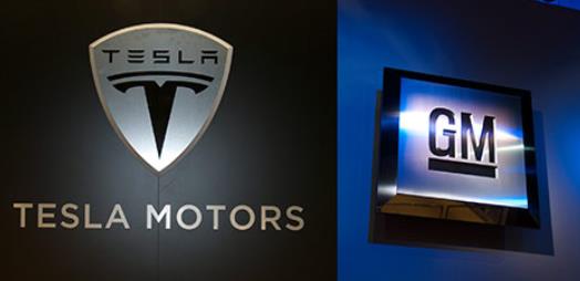
Tesla's A Threat To The Auto Industry, But Detroit's Reacting All Wrong.
LinkedIn has the story - here's a clip: "
A recent flurry of articles, such as this one on Forbes,
reported Steve Girsky’s disclosure of GM’s new secret team, tasked
with studying EV maker Tesla and its CEO Elon Musk. There is probably
no one better than Girsky, GM’s current vice chairman and a former
leading automotive analyst on Wall Street, to study and understand the
threat and opportunity that Tesla represents for the car industry.
Tesla’s $15B+ market cap demonstrates that the stock market is betting
on Tesla’s potential to take a significant share of the broader car
market, not just luxury cars. If those analysts are right, GM shouldn’t
be the only company worried about Tesla’s future plans. The entire
car industry should probably study Tesla, to understand if and how it
plans to take such market share from all current incumbents. Assuming
they will all learn the same underlying secret, what car will they
make after they finished their collective hypothetical study?..."
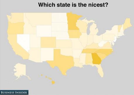
Confirming What We Already Knew. Hey, tied with Georgia? I want to
check the voting records for hanging chads. If you're interested in
seeing which states are smartest, dumbest, have the strangest accents
(we rank high in that one too) and which states respondents would most
like to kick out of the union, click on this link from Business Insider
and
imgur.com.
TODAY: Sunny & comfortable. Dew point: 47. North 10. High: 82
THURSDAY NIGHT: Clear and pleasant. Low: 61
FRIDAY: Plenty of warm sun. Dew point: 55. High: 84
SATURDAY: Few T-storms. Sticky again. Dew point: 67. Wake-up: 65. High: 87
SUNDAY: Sizzling sunshine. Feels like 100F by late afternoon. Wake-up: 72. High: 93
MONDAY: Blazing saddles. Too hot. Hazy sunshine. Wake-up: 74. High: 94
TUESDAY: Near-record heat possible. Sunny. Wake-up: 75. High: 95
WEDNESDAY: Still sunny. Still hot. Dew point: 70. Wake-up: 75. High: 93
Climate Stories...
Editor: Awaiting A Climate Change Tipping Point. Here's the intro to an Op-Ed at
The Concord Monitor: "
One
of these days, the tipping point will be reached. No, not the tipping
point that leads to a continued warming of the globe. That one,
unfortunately, is probably behind us. The even more elusive tipping
point is the action, event or increased collective concern that finally
prompts Americans to make combatting climate change a national goal
akin to winning a world war. Hurricane Katrina didn’t do it, and
neither have Hurricanes Sandy and Irene. So the notion that a slim book
and a barnstorming state senator from Iowa will spur the nation to
action seems far-fetched. But Sen. Rob Hogg’s book, America’s Climate
Century, and his talks across the state this week should move the needle
in the right direction. Hogg, who met with Monitor editors
yesterday, makes the convincing case that for the next half-century or
more “every aspect of our lives will be affected by human-caused
global warming and its resulting climate changes, and by the actions
necessary to stop climate change before it devastates the world...”
How Extreme Will Future Heatwaves Be? Choose Your Own Adventure.
The Guardian has the story - here's an excerpt: "...
Coumou
& Robinson looked at the frequency of rare and extreme (3-sigma,
meaning 3 standard deviations hotter than the average) and very rare
and extreme (5-sigma) temperature events. 3-sigma represents a
1-in-370 event, and 5-sigma is a 1-in-1.7 million event. As shown in
the video below from NASA, summer temperatures have already begun to
shift significantly towards more frequent hot extremes over the past 50
years. What used to be a rare 3-sigma event has already become more
commonplace..."
Graphic credit above: "
Summer temperatures shifting to hotter averages and extremes between the 1950s and 2000s." Source: NASA/Goddard Space Flight Center GISS and Scientific Visualization Studio.
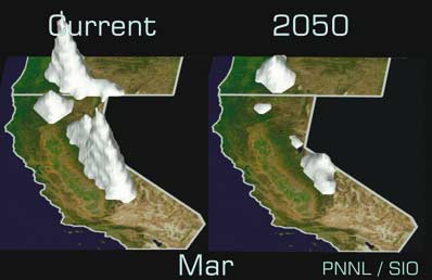
Climate Change Has Arrived In California (Op-Ed). Here's a snippet of a story at Yahoo News: "The
report concludes that climate change is occurring throughout
California, from the Pacific Coast to the Central Valley to the Sierra
Nevada Mountains.
Among other findings, the report concluded that:
- Warming temperatures have accelerated since the 1970s, with nighttime temperatures increasing much faster than daytime;
- Changes in precipitation patterns have had the effect of
decreasing water supplies, even when overall rainfall remains the
same;
- Carbon dioxide levels in coastal waters are harming species and having effects throughout the marine food chain;
- Over the past century, water levels have risen along the
California coast by an average of 7 inches (18 centimeters), and
levels have risen by 8 inches (20 centimeters) at the Golden Gate; and
- Annual acreage burned by wildfires since 2000 is double
the rate of the previous 50 years, from less than 300,000 acres to
almost 600,000..."


No comments:
Post a Comment