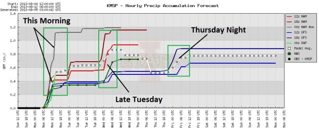
.92" rain predicted for the Twin Cities by late Tuesday night (NAM model).
76 F. high in the Twin Cities Sunday.
82 F. average high for August 4.
48 F. record low at KMSP, 1978
102 F. record high for the Twin Cities, 1947
78 F. high on August 4, 2012.
To Know The Future
“But who wants to be foretold the weather? It is
bad enough when it comes, without our having the misery of knowing
about it beforehand" wrote Jerome K. Jerome, author of Three Men in a
Boat.
News anchors and sportscasters tell you what
already happened. Meteorologists are the only ones foolish enough to
predict what tomorrow may bring.
But technology and experience only go so far.
Roughly 13 percent of 24-hour forecasts are "busts", and that number
hasn't improved, in spite of Doppler, amazing satellites & better
weather models. Yet we keep tuning in.
In a chaotic world, where little is predictable,
having any insight on expected weather gives us a hint of reassurance.
The 7-Day? Let's not go there.
The approach of tropical air ignites a spirited
round of T-storms; a few downpours are expected this morning with drippy
dew points approaching 70F - skies brightening this afternoon. Another
vigorous cool front approaches midweek, sparking more T-storms late
Tuesday and a cooler breeze by Wednesday.
We're stuck in a stubbornly persistent blocking
pattern, with northwest winds aloft keeping us cooler than average the
next 2 weeks.
A Year Without A (real) August? I think so.
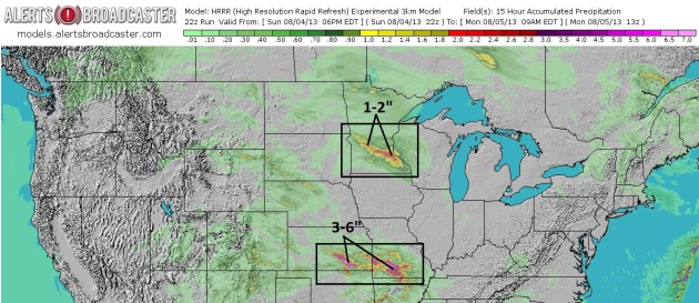
Short-Range Heavy Rain Potential. Our internal
models at Alerts Broadcaster show a heightened risk of heavy rain from
near St. Cloud and Willmar into the Twin Cities this morning, where some
1-2" rains may fall. The greatest potential for flash flooding: central
Kansas into southern Missouri, with some 3-6" rainfall amounts.
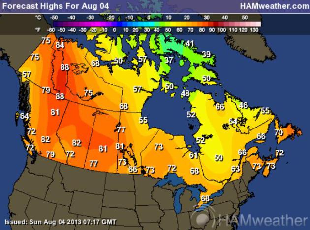
Canadian Temperature Polarization. Normally weather
moves from west to east. But a persistent blocking pattern has caused
the jet stream to take far greater north-south swings, more evidence of
"polar amplification", pulling record-setting heat into western Canada
and Alaska, while Canadians in Quebec shiver in the 50s. Graphic:
Ham Weather.
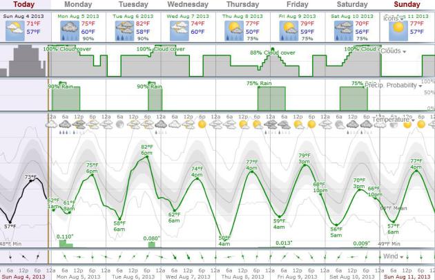
This Week's Weather Trends. I'm a fan of
Weatherspark.com
- great for climate information and, at a glance, you can get a pretty
good idea of not only temperature trends, but cloud cover and the best
times for rainfall. The data above is from the Norwegian Meteorological
Institute, which tends to do a better job than our GFS data (at least
today).
Whispers of September. We should see 80s Tuesday
afternoon, but that will be the exception to the rule, otherwise highs
in the 70s most of the week, maybe some 60s up north by Saturday.
Guidance above: ECMWF model.
Windows For Rain. The best chance of showers and
T-storms comes this morning (warm frontal passage), again late Tuesday
and Tuesday night (cool frontal passage) and again Thursday night
(another push of slightly cooler air). Many towns may pick up .50 to 1"
of rain this week, as an atmospheric tug-of-war plays out right over
Minnesota.
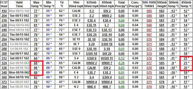
Summer Heat Third Week of August? GFS data shows
highs in the upper 80s with 850 mb temperatures above 20C by August
17-19. Yes, you may even be able to work up a sweat.
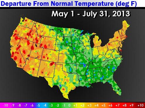
Warm Bookends. Since May 1 temperatures are running
well above average across New England and the western third of the USA;
cooler than normal from the Dakotas and Minnesota thru the Mississippi
River Valley and much of the Southeast. Source: NOAA ESRL.
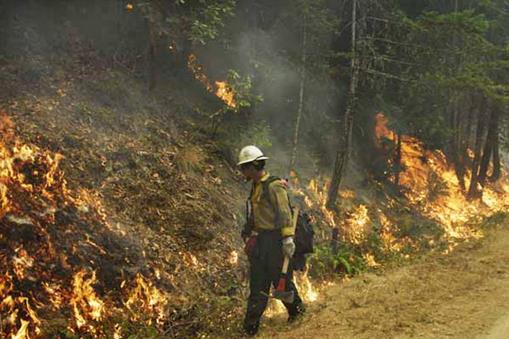
* The worst fire-season in a decade for Oregon? So says the Governor of Oregon, as reported by
seattlepi.com.
Photo credit: "A photo released by
the Oregon Department of Forestry shows a Redmond Hotshots crew on the
Douglas Complex conducting a burnout operation in the last week of
July to create a barrier to the wildfire’s advance by removing fuel in
its path.. While southern Oregon was hardest hit by thunderstorm-caused
fires last week, central Oregon picked up numerous lightning starts as
well." (AP Photo/Oregon Department of Forestry).
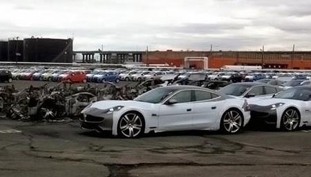
Carfax Warns Of Flood-Damaged Hybrids. If you're
shopping for a hybrid, you might want to ask a lot of questions and make
sure you're not getting a "Sandy survivor".
EV World.com has the story; here's the introduction: "
Carfax
research shows that more than 212,000 flood damaged cars, including
sker Karma and Toyota Priuses, are on the road, primarily in ten states
East Coast states. Last fall Hurricane Sandy made landfall in the New
York City area, flooding the coastline in parts of Connecticut, New
York, and New Jersey, and leaving us with indelible images of a flooded
Manhattan. One of the flooded areas was an automobile processing
facility in New Jersey that was flooded, destroying thousands of cars in
the process of being imported, including several Fisker Karma's that
caught fire. Floods occur nearly everywhere, however, and ideally flood
damaged cars are never driven on the road again, but today Carfax
issued a warning that scam artists are selling flood-damaged cars in
other states..."
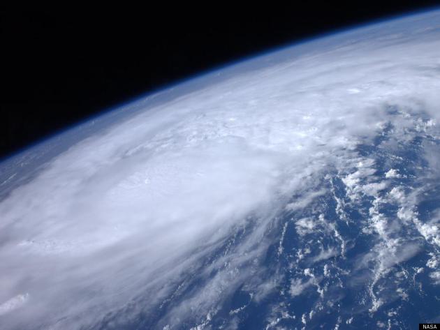
Colorado State Researchers Trim Atlantic Hurricane Outlook. I have little faith in these long-range hurricane forecasts, but in the spirit of full disclosure here's a clip from
The Capital Weather Gang: "
Expect
an above average Atlantic hurricane season say leading hurricane
researchers, but slightly less active than once thought. Phil Klotzbach
and William Gray of Colorado State University cut back their
prediction for the total number of hurricanes and major hurricanes
(category 3 or higher) by one, compared to forecasts made in April and
June. They are now forecasting 18 total named storms (including the
four which have already formed), 8 hurricanes and 3 major hurricanes
(category 3 or higher), compared to 18, 9 and 4, respectively in earlier
outlooks..." (File photo of Hurricane Irene from NASA).
Hurricane Hunters: Flying Two Storms Difficult, Three Storms Impossible.
The "Hurricane Hunters" flying out of Biloxi are watching not only
storms in the Atlantic, but their bottom line, as reported by
wlox.com; here's an excerpt: "
Hurricane
Hunters are tracking Tropical Storm Dorian while also keeping a
watchful eye on the bottom line. Military officials said with
sequestration and furloughs, the 53rd Weather Reconnaissance Squadron is
facing some tough choices as to which storms they fly into and how
often. They said that means the forecast models we depend on to tell
people to evacuate may not be as accurate. The mission of the Hurricane
Hunters is to fly into the eye of the storm and gather information to
help predict where that storm is likely to head next. However, the
403rd Wing Commander is wondering with sequestration and furloughs, how
much hunting Hurricane Hunters will be able to do. "I'll be honest
with you, it's a very significant cut in capability. It's a 20 percent
cut," said Col Craig LaFave..."
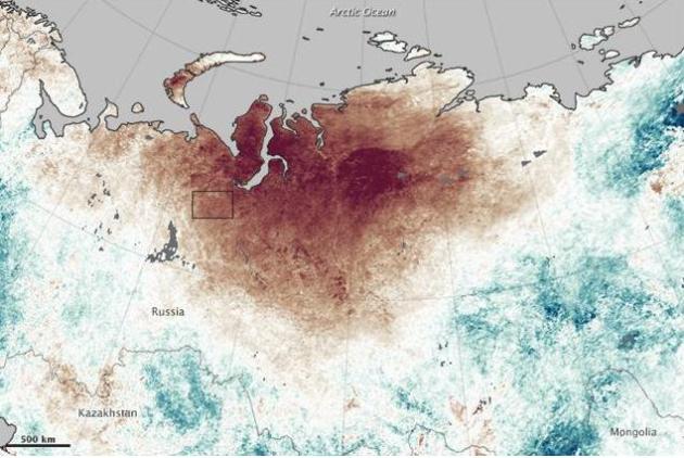
Sunburned In Siberia: Heat Wave Leads To Wildfires.
It's a strange weather map over the Northern Hemisphere - far northern
latitudes are setting record highs, while mid latitudes are trending
cooler than average, at least from the Upper Midwest to New England.
Parts of Russia are overheating, as reported by
Climate Central: "
An intense heat wave in Siberia has contributed to an unusual flare up of wildfires
across the fragile and carbon-rich landscape. Smoke from the fires is
lofting high into the atmosphere, and is drifting toward the Arctic,
where soot can hasten the melting of snow and sea ice. The Siberian
city of Norilsk, the most northerly city in the world with a
population greater than 100,000, recorded temperatures above 83°F over
eight consecutive days starting on July 18, according to blogger Chris Burt of Weather Underground.
During that timespan, Burt reported, the mercury hit 90°F, breaking
the record for the hottest temperature recorded for the city. For
comparison the average July high temperature in Norilsk is a
comparatively chilly 61°F..."
Image credit above: "
The map above shows land surface temperature anomalies for July 20–27, 2013, collected by the MODIS imager on NASA's Terra satellite." Credit: NASA Earth Observatory.
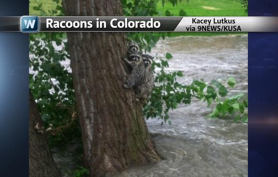
Seeking Shelter. Even a family of racoons knows what
to do when flood-waters swirl nearby. Image courtesy of KUSA-TV in
Denver and WeatherNation TV.
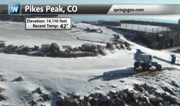
An Early Snow. I thought you'd get a kick (ugh) out
of this, a light snowfall on the summit of Pikes Peak, Colorado
Saturday, enough snow to excite die-hard skiers and snowboarders (but
nobody else). Credit: WNTV.
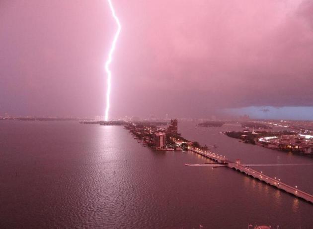
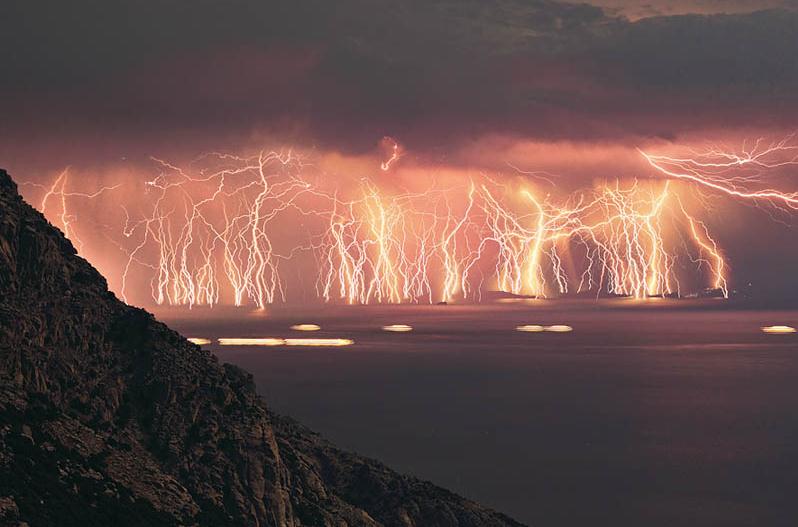
Electrifying. Photo credit: "
In case you missed it... Best strike ever over Miami Beach via Oliver Jay "
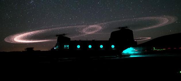
Mysterious Dancing Lights In Afghanistan. This amazing (as well as sad and poignant) story caught my eye, one of Krulwich's Wonders at
NPR: "
This
isn't a painting. It's not from a movie. It's not a strange
astronomical event. This is real — what you can see when certain
helicopters in Afghanistan touch down on sandy ground, raising dust,
causing mysterious arcs of light to loop and dance through the air. This
doesn't always happen. "The halos usually disappear as the rotors
change pitch," war photographer Michael Yon. "On some nights, on this very same landing zone, no halos form." How come?..."
Photo credit: Sgt. Mike MacLeod/U.S. Army.
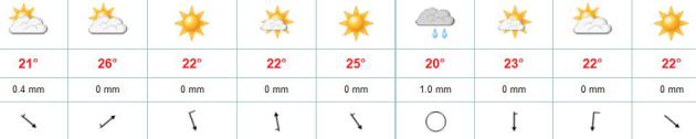
TODAY: AM T-storms, brighter PM hours. Dew point: 67. High: near 80
MONDAY NIGHT: Mild and humid. Low: 65
TUESDAY: Sticky sun, T-storms late. Dew point: 68. High: 83
WEDNESDAY: Sunny, less humid. Dew point: 53. Wake-up: 62. High: 75
THURSDAY: Partly sunny, milder. Wake-up: 58. High: 77
FRIDAY: Some sun, isolated shower. Wake-up: 59. High: 79
SATURDAY: Patchy clouds, few showers - cool for mid-August. Wake-up: 57. High: 71
SUNDAY: More sun statewide, nicer day of the weekend. Wake-up: 58. High: 76
Climate Stories...
Global Warming Will Impact The Power Grid. Here's a clip from a story at
sanluisobispo.com: "
The
power distribution grid is a remarkable machine that regulates and
transports vast amounts of electrical energy that we use in our homes
and businesses. It’s there out in the open for all of us to see; in
fact, it’s so wide open, most of us don’t even notice the lines and
poles any longer. It's only during a power outage when you actually
think about it. Unfortunately, a new report released by the Department
of Energy in July, says that our electrical grid will be impacted due
to the effects of global warming. Over the last century, air and ocean
temperatures have continued to increase and droughts have become more
prolonged. Both of these conditions have produced a seemingly
never-ending fire season across the Western United States. July 2012
was the hottest month ever recorded in the United States and 2012 was
the warmest year overall..."
Photo credit above: "Transmission lines along Highway 41 near Morro Bay." JOHN LINDSEY.
"...
Did you know air conditioner use in the U.S. results in an average of about 100 million tons of CO2 emissions from power plants every year ?..." - from an Op-Ed at
Huffington Post.
Permafrost Melting Faster Than Expected In Antarctica.
StateImpact Texas from NPR has the story - here's the introduction: "
New
research shows melting at rates comparalbe to the Arctic. Unlike the
Arctic Circle up north, where once-permanent sea ice began melting
and miles of permafrost began thawing decades ago, the ground ice in
Antarctica’s Garwood Valley was generally considered stable. In this
remote polar region near the iceberg-encrusted Ross Sea, temperatures
actually became colder from 1986 to 2000, then stabilized, while the
climate in much of the rest of the world warmed during that same
period. But now, the ice in Antarctica is melting as rapidly as in the
Arctic..."
Photo credit above: Dr. Joseph Levy / The University of Texas Institute for Geophysics. "
Research team member Jim O'Connor of the USGS inspects a block of ice calved off the Garwood Valley ice cliff."
Small Businesses Face "Major Extreme Weather Challenges".
Environmental Leader has the article; here's an excerpt: "
US
small businesses — which employ 60 million Americans, or about half
of the workforce — are particularly at risk from extreme weather and climate change
and must take steps to adapt, according to a report from Small
Business Majority (SBM) and the American Sustainable Business Council
(ASBC). Climate Change Preparedness and the Small Business Sector
says the retail, tourism, landscape architecture, agriculture,
roofing, and small-scale manufacturing sectors are more vulnerable to
the financial implications of climate change than their larger
corporate counterpart.
The report finds:
- Lacking access to the capital and resources of large
corporations, small businesses can suffer lasting economic damage as a
result of a single extreme weather event. For example, of the 60,000
to 100,000 small businesses negatively affected by Hurricane Sandy, up
to 30 percent are estimated to have failed as a direct result of the
storm..."


No comments:
Post a Comment