81 F. high in the Twin Cities Monday.
82 F. average high on August 5.
76 F. high on August 5, 2012.
.65" rain fell Monday morning at MSP International.
Slight severe storm risk today.
Relative Risk
The older I get the more grudging respect I have
for Mother Nature. My old scouting motto "Be Prepared" comes to mind;
there are always steps you can take to lower your odds of becoming a
hapless weather statistic.
But some perspective is in order. According to
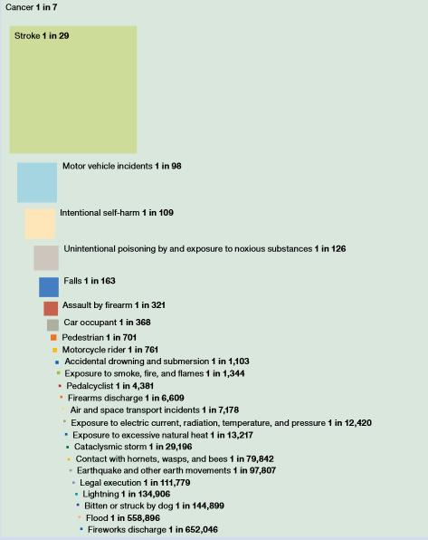
The National Safety Council the risk of dying from heart disease is 1 in
6. Stroke: 1 in 29. In stark contrast the odds of perishing in a heat
wave is 1 in 13,217. Lightning? 1 in 134,906.
My theory: weather-related deaths are often
deemed newsworthy; they tend to pop up on the front page of newspapers
and lead local TV news. So the perception of risk is a highly inflated
version of reality. I still won't golf in a T-storm or drive thru a
flooded street. Hey, I want to enjoy future grandkids!
Speaking of weather risk, a few storms may turn severe later today with (isolated) hail & high winds.
Dew points sink into the 40s Wednesday under
blue sky - another spectacular taste of September. It doesn't look as
cool for late week: expect 70s next weekend, a few T-showers far south.
PS: Want to lower your weather risk? Have a few radar/alerting apps on your smart phone. And buy a NOAA Weather Radio.
Cheap life insurance.
Lifetime Odds Of Death For Select Causes. The graphic above from
The National Safety Council quickly puts weather risk into stark perspective, compared with all the other medical and socioeconomic threats.
Excessive heat: 1 in 13, 217
Cataclysmic storm: 1 in 29,196
Lightning: 1 in 134, 906
Flood: 1 in 652,046
Perspective. According to an article at
The Deseret News,
the odds of dating a supermodel are 1 in 88,000. Those are your odds.
My odds? Considerably less than that, as my wife of 29 years just
reminded me.
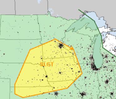
Tuesday Severe Threat. The combination of moderate
instability, surface dew points in the mid-60s and an approaching
trigger (a stronger-than-average cool frontal passage) may spark a late
afternoon/evening squall line capable of hail and straight-line winds.
SPC has the southern half of Minnesota in a slight risk - expect a few
watch boxes later today.
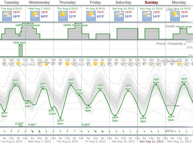
Weather Trends. Check out the latest
WeatherSpark
outlook, breaking out temperature trends (still running cooler than
average), along with predicted cloud cover and wind direction/speed into
next Monday. The run above uses European data - you can call up U.S.
data as well to power the 7-Day.
A Fine Spell Of Weather. With the exception of
today's strong/severe storm risk, the rest of the week and weekend looks
fairly quiet, temperatures a few degrees cooler than average. A shower
may pop up late Thursday ahead of a reinforcing push of cooler, drier
air in time for the weekend. Models keep most of the showers and
T-storms south and west of Minnesota Saturday and Sunday. ECMWF forecast
highs above in Celsius.
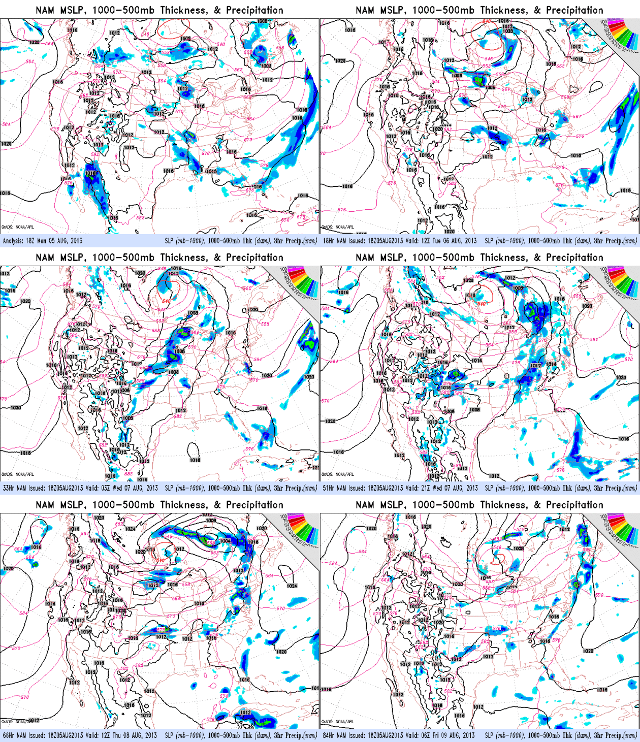
Time Warp. The maps still look like something out of
the first or second week of September; the core of the jet stream
200-400 miles farther south than usual for early August. Yes, it should
be cooling down (slightly), but sweatshirts, light jackets and a handful
of record lows over the northern USA...in August? Unusual. The next
surge of Canadian air sparks a few severe storms over the Upper Midwest
today, pushing across the Great Lakes and Ohio Valley Wednesday,
reaching New England and the Mid Atlantic region Thursday. The tropics
are still quiet.
Long Odds. Compared to various diseases, traffic
accidents, etc - the risk posed by extreme weather is relatively small.
Unless, of course, you're at the wrong place at the wrong time - or not
paying attention. In today's edition of
Climate Matters
we celebrate the long odds of Powerball Mania, try to put statistics
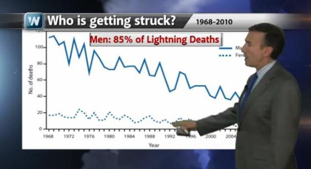
into perspective, and wonder (out loud) why men are a LOT more likely to
be struck by lightning than women.
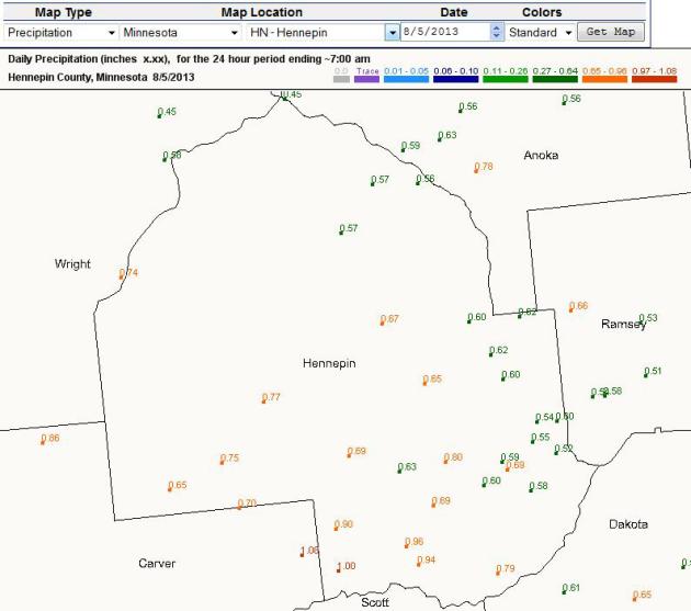
High Resolution Rainfall Maps. Interested to see how much rain just fell in your county. Check out the powerul
CoCoRaHS Network,
which is updated in real-time. It shows some 1" amounts over southwest
Hennepin County Monday morning, while closer to .5 to .6" fell in
downtown Minneapolis, about .50" in St. Paul.
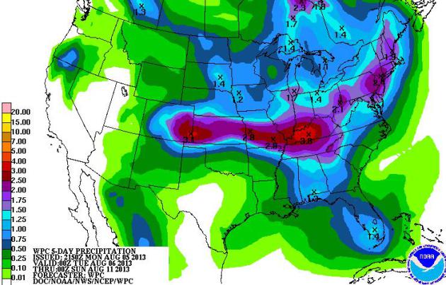
5-Day Rainfall. NOAA HPC shows the heaviest rain
bands this week setting up from near Denver to Kansas City and
Louisville, more heavy showers and storms from Pittsburgh to New York
City (some 2"+ amounts expected). These storms, and subsequent flash
flooding, will develop along the boundary between relatively cool,
Canadian air over the northern USA and baking heat over the Deep South.
Falling Prices Cloud Outlook For Minnesota Corn Farms. Prices have eased right along with the drought, as reported by
The Star Tribune; here's an excerpt: "
Minnesota
cropland values surged again the past year as farmers reeled in big
paychecks. This year’s crops are looking decent, overcoming a sodden
spring and late planting. The weather has been good. In fact,
everything is so good it may be too good, or so goes the logic of
farming economics. With big grain crops expected through much of the
nation, the price of corn has dropped to levels not seen since 2010.
That means farmers who’ve sunk more money into land and equipment
during boom times — thus increasing their costs — are looking at
thinning margins this year if corn prices stay where they are..."
Photo credit above: "
Cropland values surged 20 percent in Minnesota from last year after farmers posted their best year in decades." Photo: Brian Peterson, Star Tribune
The 2013 Perseid Meteor Shower: An Observer's Guide.
There's some very good information on one of the major celestial events
of the year, peaking in the near future. With this flurry of
September-like fronts, less haze and better visibility you stand a
better chance of seeing a lucky shooting star or two, especially if you
can get away from the light pollution of the Twin Cities.
Universe Today has more details: "
Get
set for the meteoritic grand finale of summer. Northern hemisphere
summer that is. As we head into August, our gaze turns towards that “Old
Faithful” of meteor showers, the Perseids.
Though summer is mostly behind us now, “meteor shower season” is about
to get underway in earnest. Pronounced “Pur-SEE-ids,” this shower falls
around the second week of August, just before school goes back in for
most folks. This time of year also finds many the residents of the
northern hemisphere out camping and away from light-polluted suburban
skies. This year also offers a special treat, as the Moon will be safely
out of the sky during key observation times..."
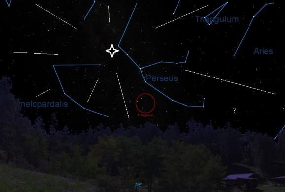
Image credit above: "
The radiant for the Perseids, looking to the NE from latitude ~30N at around 2AM local." Created by the Author in
Starry Night).
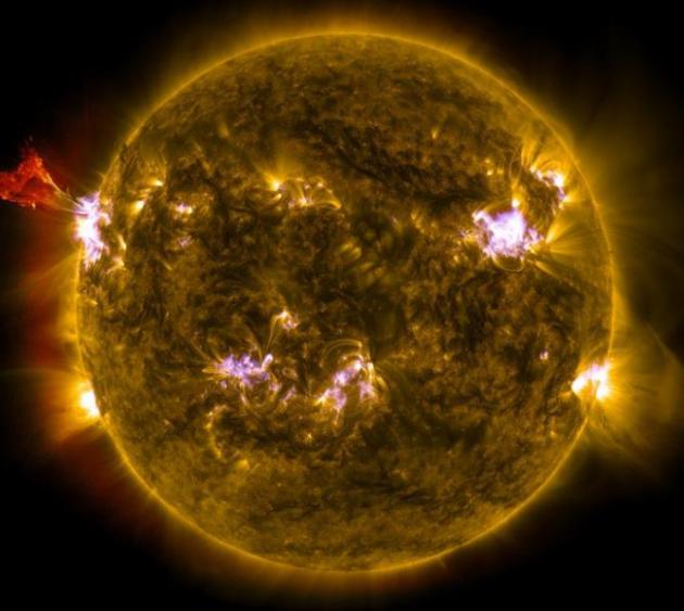
NASA Launches VERIS Rocket To Study Sun's Explosive Behavior. Here's a clip from a story at
Science World Report: "...
On
the sun, these large scale energy releases are driven by small scale
physical processes," said Clarence Korendyke, one of the researchers, in a news release. "So
we need to look at and understand the tiny details of those processes."
VERIS's flight will only last six minutes, but it will yield a bounty
of information. It will gather a kind of data known as spectra of this
region of the sun at an extremely high resolution. Spectra will provide
information on how much of any given wavelength of light is present.
This, in turn, can allow researchers to see the different temperatures
of plasma present on the sun. In addition VERIS will collect density and
velocity information about the active region. This will allow
scientists to determine which theory is correct when it comes to how the
sun is heated..."
Image credit above: "
Want to learn more about the sun?
NASA certainly does. The space agency is planning on launching a
sounding rocket, called VERIS, on August 8 in order to learn a bit more
about our closest star. This image combines three images from NASA's
Solar Dynamics Observatory captured on May 3, 2013, at 1:45 pm EDT,
just as an M-class solar flare from the same region was subsiding." (Photo : NASA/SDO/AIA).
This Breathtaking Panorama Of Tokyo Is The Second Largest Photo In The World. I'm feeling even more inadequate than usual with my (minimal) megapixels. Check out this excerpt from
gizmag.com: "
Photography
group 360Cities seems determined to capture every major city in the
world in as much detail as possible. Shortly after putting together a 360-degree panorama of London
and breaking the record for world's largest photo in the process, the
group's founder Jeffrey Martin set his sights on Tokyo for his next
project. This latest panorama may not trump his old record, but at 180
gigapixels, it's still the second largest photo ever taken..."
Photo credit above: "
Photographer Jeffrey Martin of
360Cities recently unveiled a 360-degree panorama of Tokyo measuring
180 gigapixels, making it the second largest photo in the world."
* a four-year old mayor is reelected in northern Minnesota? Say what? Details
here.
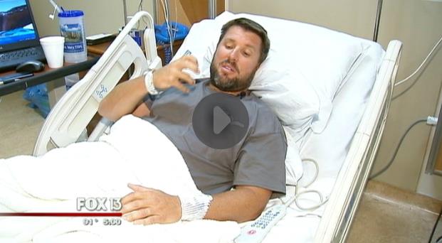
The Opposite Of Lucky. You might want to keep your
distance from this poor guy, who has endured a spell of unbelievably bad
luck, including a recent shark bite. But wait, there's more.
My Fox Tampa Bay has the head-shaking details; here's an excerpt: "...
The
family said their prayers got them through the worst part of this
ordeal and they are certain their strong faith will take them to
whatever the next challenge ahead is. By the way,
Norrie has also been struck by lightning, and his right leg has been
bitten by a rattlesnake. He's also been punched by monkeys twice, and
now can claim that he's survived a major shark bite..."
* is it just me, but "punched by monkeys twice" made me a little
weak in the knees. That may be the most remarkable sentence I've ever
seen in print. After the first monkey mugging I think I'd get the
message....
TODAY: Warm and muggy, PM storms, some strong to severe. Dew point: 65. Winds: SW 10-15+ High: 82
TUESDAY NIGHT: Evening T-storms, some heavy - clearing and cooler late. Low: 63
WEDNESDAY: Sunny and cooler; big dip in humidity. Dew point: 49. High: 75
THURSDAY: Partly sunny, thunder risk late in the day and at night. Wake-up: 59. High: 76
FRIDAY: Mix of clouds & sun, lukewarm. Wake-up: 60. High: 77
SATURDAY: Sunny intervals, not bad. DP: 57. Wake-up: 58. High: 76
SUNDAY: Breezy and comfortable. Wake-up: 59. High: 77
MONDAY: Plenty of sun, hints of September. Wake-up: 57. High: 75
Climate Stories...
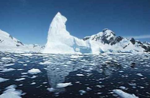
Climate Change Pushing Marine Life Towards The Poles, Says Study.
The Guardian has the story - here is the introduction: "
Rising
ocean temperatures are rearranging the biological make-up of our
oceans, pushing species towards the poles by 7kms every year, as they
chase the climates they can survive in, according to new research. The
study, conducted by a working group of scientists from 17 different institutions,
gathered data from seven different countries and found the warming
oceans are causing marine species to alter their breeding, feeding and
migration patterns. Surprisingly, land species are shifting at a rate of
less than 1km a year in comparison, even though land surface
temperatures are rising at a much faster rate than those in the ocean..." (Image: National Science Foundation).
Electric Car Sales Up 520% Over 2012.
Gas2.org has the details: "
The numbers are in for “mass-market” 100% electric vehicle (EV), plug-in hybrid electric vehicle (PHEV), and conventional hybrid electric vehicle
sales. Well, the numbers are in from everyone but Tesla and Fiat. (The
Tesla Model S total in the colorful spreadsheet below is an estimate
based on quarterly sales updates, since the rockstar EV company doesn’t
report monthly sales.) As you can see in the embedded spreadsheet, I
use green highlighting to show when year-over-year change is positive
and I use red highlighting to show when it is negative. Paying
attention to that very complicated system, you can see that everything
is green in the sales totals for 100% EVs, PHEVs, and conventional
hybrids — for both July 2013 and YTD 2013..."
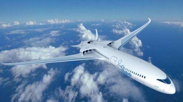
Hybrid Planes Trying To Charge Into Action. No-guilt
flying, all on electrical power, no greenhouse gases emitted? It may
become a reality sooner than you suspect, according to
The BBC. Here's an excerpt: "
How
would you feel about flying on an electric airliner? Current planes
may be noisy, rattly, and relatively inefficient, but there’s something
reassuring about being able to hear the constant roar of the engines,
or glance out of the window and see them. So the airliner of the future
may feel very alien to anyone comfortable with our current mode of
flying – at least if an ambitious model called the eConcept is anything
to go by. Designed by European aviation powerhouse, EADS (which
announced it will be renamed Airbus Group
next year), together with Rolls Royce, the eConcept shows how
cutting-edge technology and materials could combine to make more
efficient and quiet aircraft that take their cues from the hybrid-car
model..."
Image credit above: "
Silent revolution. Ambitious ideas on
the table for hybrid-like planes could mean the airliner of the future
may look, feel and sound very different to today’s models." (Copyright: EADS)
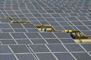
Future Of Solar Power: How About Transparent Solar Cells That Can Be Put On Windows? Sounds like a great idea to me. Here's a clip from a story at
The Economic Times: "...
The other breakthroughs are a transparent solar cell from the University of California
in Los Angeles, a simple solar cell from Germany that can split water
and produce hydrogen, and a photovoltaic-thermal system from Canada.
Transparent solar cells are an exciting development as they can be put
on windows, gadgets and in other places to generate electricity on the
sly. Producing hydrogen from water using sunlight is a dream of the
solar energy world, as it lets us store the energy — in the form of
hydrogen gas or in a fuel cell — that can be used at night or on cloudy
days. Combining photovoltaics with thermal uses both light and heat
from the sun. There is a long way from a technology demonstrator in the
lab to a commercially successful device. In the field of solar energy,
this is important, as the cost of commercialisation can at times be
very high..."
Photo credit above: "
Scientists use a plasmonic solar cell that uses the bizarre laws of quantum mechanics to achieve high efficiency at low cost."
Global Warming Denial Is Science-Proof.
Slate has the story - here's the introduction: "
Every
time I see an opinion piece written by a global warming denier I think
to myself, “Well, this’ll be painful, but at least it can’t get any
worse than the one’s I’ve already read.” And then I read it. And I find
out I was wrong. So here I am again, shaking my head after reading yet
another in a long line of global-warming denial articles making bizarre
claims. This one was written by Rich Trzupek and is entitled “Michael Mann Redefines Science”. The title alone told me I was in trouble—Mann is actually a respected climate scientist
(except in the antireality-o-sphere, that is)—and then I saw where
this gem was posted: on the Heartland Institute’s blog. You remember the Heartland Institute, right? They’re the ones who put up billboards comparing climate scientists to mass murderers and dictators, which caused such a foofooraw that they hemorrhaged sponsors. They had to take the billboards down, but then declared the campaign a success..."
Seven Facts You Need To Know About The Arctic Methane Timebomb. Alarmist hype, or cause for genuine alarm?
The Guardian has the article; here's a clip: "
Debate over the plausibility of a catastrophic release of methane in coming decades due to thawing Arctic permafrost has escalated after a new Nature paper
warned that exactly this scenario could trigger costs equivalent to the
annual GDP of the global economy. Scientists of different persuasions
remain fundamentally divided over whether such a scenario is even
plausible. Carolyn Rupple of the US Geological Survey (USGS) Gas
Hydrates Project told NBC News
the scenario is "nearly impossible." Ed Dlugokencky, a research
scientist at the National Oceanic and Atmospheric Administration's
(NOAA) said there has been "no detectable change in Arctic methane
emissions over the past two decades." NASA's Gavin Schmidt said that ice
core records from previously warm Arctic periods show no indication of
such a scenario having ever occurred..."
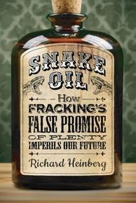
The False Promise Of Fracking. I'm keeping an open
mind, realizing that we're going to need a lower-carbon fuel source to
get us from coal and oil to renewables. It's been well documented that
natural gas releases roughly half as much CO2 into the atmosphere as
coal - assuming methane leakage around the wells are kept to a minimum, a
potentially huge assumption. We have a pretty good handle on the
(considerable) benefits, I'm just not sure we have a handle on all the
costs related to hydraulic fracture. I'm just glad there's no shale oil
under Minnesota -
Triple Pundit has the story; here's an excerpt: "...
Heinberg
says his research shows that “rather than offering the nation a
century of cheap energy and economic prosperity, fracking may well
present us with a short-term bubble that comes with exceedingly high
economic and environmental costs.” Heinberg continues, “Horizontal
drilling and hydrofracturing (“fracking”) for oil and gas pose a danger
not just to local water and air quality, but also to sound energy
policy, and therefore to our collective ability to avert the greatest
human-made economic and environmental catastrophe in history.”
In his analysis of shale production to date, Heinberg says:
- Industry claims of a long-term economic bonanza and energy
security as a result of domestic drilling for shale gas and shale
(tight) oil.
- The perception that shale gas and tight oil drilling will
provide long-term, low cost supplies. The oil industry “has overstated
world oil reserves by about a third and is working harder and harder
just to stand still...”
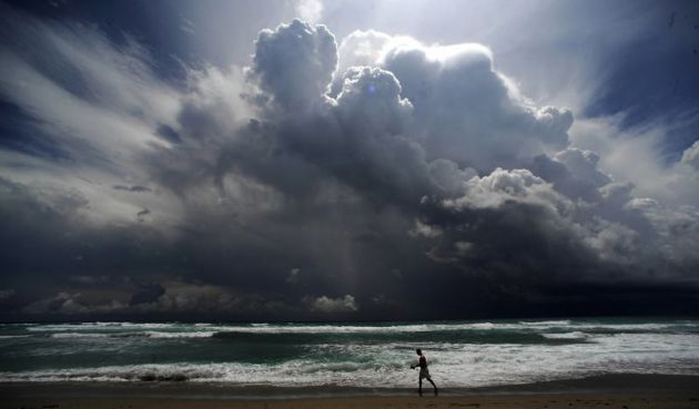
It Never Rains But It Pours. Here's an excerpt of a story at
The Hindu Business Line in India: "...
Models
project substantial warming in temperature extremes by the end of the
21st century. It is virtually certain that increases in the frequency
and magnitude of daily temperature extremes and decreases in cold
extremes will occur on a global scale. It is very likely that the
length, frequency, and/or intensity of warm spells or heat waves will
increase over most land areas. Based on certain emissions scenarios, a
one-in-twenty-years hottest day is likely to become a one-in-two-years
event by the end of the 21st century in most regions, except in the
high latitudes of the Northern Hemisphere, where it is likely to become
a one-in-five-years event. Further, it is likely that the frequency of
heavy precipitation or the proportion of total rainfall from heavy
falls will increase in the 21st century over many areas of the globe..."








No comments:
Post a Comment