67 F. high in the Twin Cities Monday, after a morning low of 44 F.
72 F. average high on September 16.
80 F. high on September 16, 2012.
+1.6 F Meteorological summer (June thru August) was 1.6 F. warmer than average at MSP.
+3.5 F. Temperature anomaly during meteorological summer, 2012.
 Hot Tea Alert
"Man plans, God laughs".
That's especially true when traveling by air, but I have a solution: only fly on sunny days.
Last
week my flight to Baltimore was delayed 3 hours when lightning struck
the control tower at BWI. Flying home yesterday I was dozing contently
when clear air turbulence dumped hot tea into my crotch. Pain, then an
oddly refreshing sensation.
Sorry for the visual.
My point:
in spite of all our computers, gizmos & redundancies you can't push
the weather. Summer T-storms trigger more airline delays than winter
snow & ice, especially over southern and eastern states. The only
thing you can do to lower the risk of getting delayed or cancelled is
fly in the morning, before instability T-storms have a chance to pop up
and wreak havoc.
Fall is in the air, but summer isn't through with
us yet. Highs may hit 80F tomorrow, again early next week. Midweek dew
points reach the sticky upper 60s before a cleansing breath of cooler,
drier, Canadian air arrives by Friday & Saturday.
And yes, it's perfectly acceptable to wear a light jacket over your shorts. Expect more wardrobe confusion ahead.
The best chance of rain comes Thursday, followed by a dry, lukewarm weekend. Models show a few more 80s into early October.
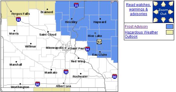
A Little Close For Comfort.
Morning temperatures dipped into the upper 20s over much of northern
Minnesota and Wisconsin Monday morning - another frost is possible early
today. If you missed a frost the past couple of nights odds are you'll
stay frost-free thru the end of the week. Map above from the
Twin Cities National Weather Service.
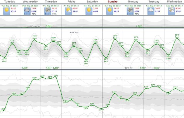
Above Average.
ECMWF guidance shows 70s the next 3 days, followed by a brief late week
cooling trend - Friday the coolest day in sight. Highs may approach 80F
again by Sunday, a mild bias into much of next week as well. Showery
rains, even some thunder, is possible Thursday, but no soakings are in
sight yet. Graph: weatherspark.com.
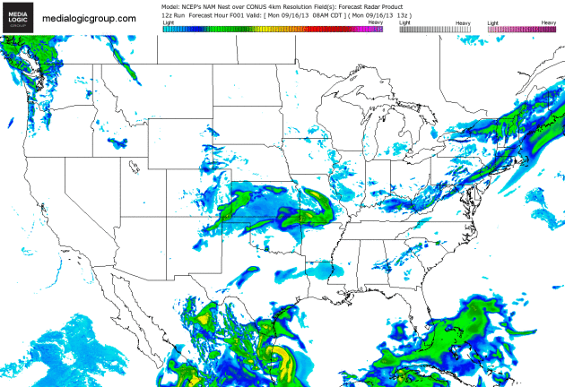
Tracking Ingrid - And A Showery Swirl Into The Midwest.
The 4 km. NAM shows showers and possible T-showers sprouting along the
leading edge of warmer air pushing north across the Plains into the
Midwest. Colorado (finally) dries out a bit, while the soggy remains of
Hurricane Ingrid push into Mexico, a few heavy rain bands brushing far
southern Texas. Animation: NOAA and Ham Weather.
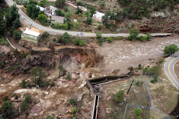
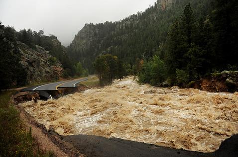
Historic Flooding Across Colorado. You only get so much from the written word, statistics and numbers. After seeing some of the photos in this piece from
The Atlantic you get a much better sense of the scope of this flooding disaster: "
Over
the past few days, a 4,500-square-mile area across Colorado's Front
Range has been hit by devastating floods, leaving at least six dead,
forcing thousands to evacuate, and destroying thousands of homes and
farms. Record amounts of rainfall generated flash floods that tore up
roads and lines of communication, leaving many stranded, and hundreds
still listed as missing. Evacuations are still underway as weather
conditions have improved slightly. Forecasters predict drier weather by
mid-week. Gathered here are recent images of the devastation in Colorado."
Photo credit above: "
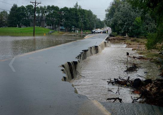
A
raging waterfall destroys a bridge along Highway 34 toward Estes Park,
Colorado, as flooding devastates the Front Range and thousands were
forced to evacuate, on September 13, 2013."
(AP Photo/Colorado Heli-Ops, Dennis Pierce).
* In Longmont, Colorado they're already calling this a
1 in 500 year flood.
Flood Transforms Colorado's "Gore-Tex Vortex". Here's a clip from The AP and
KUSA-TV in Denver: "
The
cars that normally clog Main Street in Lyons on the way to Rocky
Mountain National Park have been replaced by military supply trucks.
Shop owners in Estes Park hurriedly cleared their wares in fear that the
Big Thompson River will rise again. A plywood sign encouraged residents
mucking out their homes to "Hang in there."Days of rain and floods have
transformed the outdoorsy mountain communities in Colorado's Rocky
Mountain foothills affectionately known "The Gore-Tex Vortex" from a
paradise into a disaster area with little in the way of supplies or
services - and more rain falling Sunday. The string of communities from
Boulder to Estes Park, the gateway to Rocky Mountain National Park, is a
base for backpackers and nature lovers where blue-collar and yuppie
sensibilities exist side by side. Now, roadways have crumbled, scenic
bridges are destroyed, the site of the bluegrass festival is washed out
and most shops are closed..."
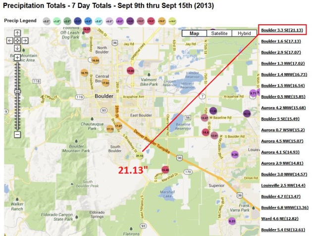
* Map above, courtesy of
NOAA, shows 21.13" of rain in the last 7 days in falling on South Boulder.
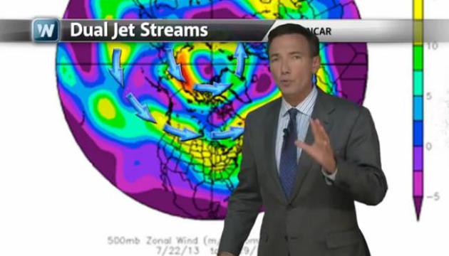
Historic Flooding Continues To Ravage Colorado.
It was the Perfect Storm for the Front Range. Stalled synoptic-scale
storm near Salt Lake City, turning on an extended 5-6 day "fetch" of
tropical moisture originating from the eastern Pacific with record
precipitable water values - combined with a stubborn upslope flow that
created wave after wave of heavy rain. "Atmospheric Rivers" are thought
to pose the greatest risk to California, but there's no reason why a
river of excessive moisture can't set up from southwest to northeast, as
it did late last week. Today's
Climate Matters segment
looks at the Colorado Flood; natural weather enhanced by strange twists
and turns in the jet stream (and more water vapor) that may be a direct
result of a slowly warming climate.
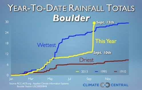
Flood-Ravaged Boulder, Colorado Sets Annual Rainfall Record. This takes weather whiplash to a whole new extreme. Here's a clip of
Climate Central story from meteorologist Andrew Freedman, with some remarkable rainfall statistics: "...
With
30.12 inches of rain and counting, more than half of which fell since
Sept. 9, the city has already eclipsed its previous mark of 29.93
inches, set in 1995. Boulder's average yearly precipitation (rain and
melted frozen precipitation) is 20.68 inches. The record is especially
noteworthy since before Sept. 9, Boulder, along with much of eastern
Colorado, was still mired in long-term drought conditions..."
Graphic credit above: "
So much rain fell since Sept. 9 that Boulder, Colo., went from having one of its driest years on record to its wettest." Credit: Dennis Adams-Smith/Climate Central.
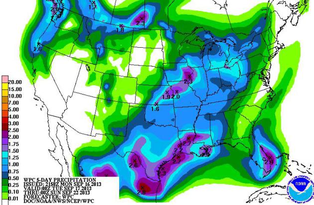
5-Day Rainfall.
NOAA HPC prints out heavy rains for coastal Texas, a 1-2"+ smear of
rain from near Kansas City to Davenport, more heavy showers and T-storms
for south Florida. The Pacific Northwest sees a healthy soaking, while
much of the Southwest stays dry.
Colorado Floods: Death Toll Climbs As Hundreds Still Stuck.
The Denver Post
has a town by town update on historic flooding still underway - it will
take months, if not years for some of these communities to return to
some sense of normalcy. Here's an excerpt: "
As
many as 1,000 Larimer County residents remain trapped by washed-out
roads in mountain canyons after helicopters set to rescue them were
grounded by rain and fog Sunday.
"Mother Nature is not cooperating," said Shane DelGrosso, one of two
Type II incident commanders who are assisting the county with
coordination of local, state and federal rescue efforts.
Saturday, 475 people were evacuated by air and taken to shelters in the
county. Two 80-person urban search and rescue teams will arrive Monday
and begin house-to-house searches around Estes Park, where the only
passable route in and out of town is Colorado 7..."
Photo credit above: "
The
eastbound lane of 9th Ave collapsed near Fordham St in Longmont, CO
September 15, 2013. Evacuations are underway Sunday morning in some
Longmont neighborhoods because the St. Vrain River is rising quickly." (Photo By Craig F. Walker / The Denver Post).
*
Only 22,000 homes and businesses in Colorado have flood insurance,
roughly 10-25% of people living in high risk flood zones have coverage.
This will compound the disaster for survivors according to USA Today.
NWS Says Flooding "Historically Significant". No kidding. Here are more details from
The Boulder County Business Report: "
Is
this week's flooding in Boulder County a 100-year event? Five hundred?
One thousand? Jim Keeney, weather program manager for the National
Weather Service's Central Region, said the NWS hasn't made a
determination because flooding is still rampant along Colorado's Front
Range. But he did offer one comparison to lend some perspective on
Friday. The Big Thompson River flood of 1976 has long been a sort of
benchmark for flooding in the region. That flood crested at 9.31 feet in
the town of Drake. The flooding that slammed the foothills and Front
Range this year crested at 10.55' Friday morning..."
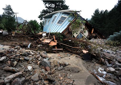
Photo credit above: "
A
house lays completely demolished in what was the path of the recent
floods that have destroyed the town of Jamestown, Colo., on Sunday Sept.
14, 2013. No one has been able to access the town until late Sunday
afternoon when crews finalized repairs of the upper portion of the road
for emergency traffic only. The town has no infrastructure or running
water. Some parts of town amazingly enough have electricity. A dozen or
so residents stayed as most of the town was evacuated by helicopters." (AP Photo/ The Denver Post, Helen H. Richardson)
What We Learned From Vermont's Epic Flood.
CNN has the story - here's a snippet: "...
From that emergency response, we learned a few critical lessons that I offer for our counterparts in Colorado:
Sleep and eat. This
flood emergency response will continue for many weeks. It is a
marathon, not a sprint, and you and your staff can only be helpful if
you take care of your own basic needs.
Ask for help.
Many folks want to help, including experts who are prepared to pitch in
at a moment's notice. Take some time to think carefully about where you
could use the extra boots on the ground and ask for assistance.
Communicate. The
first casualty of a crisis is information. Make sure you have the facts
before you act. Talk to the folks in the field. Share relevant
information with the emergency response directors. Let the public know
what you know through updates and guidance from your experts. You cannot
communicate too much..."
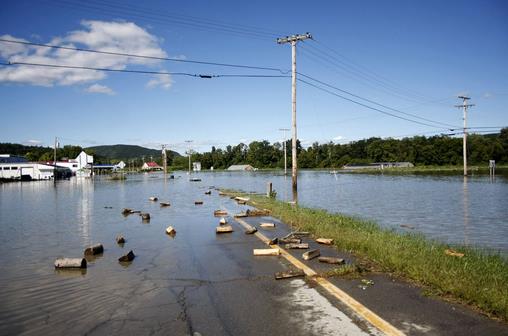
File photo credit above: "Water
from the Connecticut River floods Route 5 in Westminster, Vt. Tuesday,
Aug. 30, 2011, after Tropical Storm Irene moved through the area over
the weekend." (AP Photo/The Brattleboro Reformer, Zachary P. Stephens).
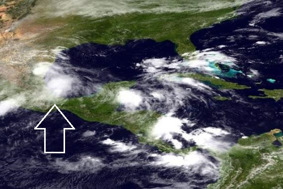
Ingrid Fizzles.
Once-hurricane Ingrid should weaken rapidly today as it pushes into
Mexico; some of the outer bands brushing far southern Texas (Brownsville
area) with heavy rain and 30 mph wind gusts. More details from NOAA: "
Monday
morning (9/16/2013), the NOAA NWS National Hurricane Center indicated
that Tropical Storm Ingrid continues to move farther inland from the
eastern coast of Mexico, centered at midday about 25 miles west of La
Pesco. A Tropical Storm Warning continues along the coast of Mexico from
La Cruz northward to Rio San Fernando. Maximum sustained winds are 60
mph. Ingrid is forecast to weaken to a depression later today and
dissipate on Tuesday. These rains are likely to produce life-threatening
flash floods and mud slides."
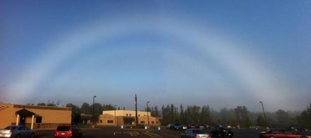
Fogbow. When it's time to graduate from just-another-rainbow. Details from
WeatherNation TV: "
Here's
a cool weather phenomenon! This photo was taken in Cloquet, MN. Fog
bows are similar to rainbows, except due to a smaller droplet size,
white is the color reflected to the eye instead of the normal ROYGBIV.
Photo from Jason Hollinday via NWS Duluth, MN."
From Crankstarting To Charging: Why Tesla's Model S Is The Model T Of Our Time. Here's a clip from a long and excellent article about Tesla, redefining the meaning of disruptive innovation, courtesy of
Digital Trends: "
What
is the future of the automobile? One hundred years ago, America was in
the midst of a mobility revolution as the Ford Model T put the nation on
wheels for the first time. Today, we’re seeing the next era of mobility
begin to unfold, and much of the credit goes to that EV icon, the Tesla Model S. After more than a century of driving gasoline and diesel-powered cars,
hybrids and fully electric vehicles are finally beginning to chip away
at the market share of their fossil-fueled forefathers. So what has a
century of progress wrought? I recently had the chance to get two
revolutionary cars – a 1913 Ford Model T and a 2013 Tesla Model S –
together at the same time to see where we’ve been and where we’re
headed. While electric vehicles today seem like something from a science
fiction future, the truth is they’re as old as cars themselves..."
The iPhone's Secret Flights From China To Your Local Apple Store.
Apple flies chartered 777's from China, each one loaded with 400,000+
iPhones. Who knew? Here's an excerpt of a fascinating tale from
Bloomberg: "
As Apple CEO Tim Cook unveiled new iPhones
yesterday, a complex operation had already kicked into gear behind the
scenes to send millions of the handsets to store shelves worldwide. The
process starts in China, where pallets of iPhones are moved from
factories in unmarked containers accompanied by a security detail. The
containers are then loaded onto trucks and shipped via pre-bought
airfreight space, including on old Russian military transports. The
journey ends in stores where the world's biggest technology company
makes constant adjustments based on demand, said people who have worked
on Apple's logistics and asked not to be identified because the process
is secret..."
Photo credit above: Simon Dawson/Bloomberg. "
Boxes of Apple Inc. iPhones are stacked in a London store."
Texas A&M - Alabama: Inside College Football's Supercharged Economy. If you had any doubt that college football is BIG business, check out this story at
TIME Magazine's Keeping Score Blog; here's an excerpt: "...
Still,
no scene captured the perks of college football quite like College
Station on Saturday. Games like Bama-A&M deliver psychic benefits to
guys like Robinson, publicity benefits to Texas A&M, economic
benefits to everyone from sponsors to shirt-sellers to the port-o-potty
operators. Thanks to Manziel, a polarizing figure who was accused of
accepting money for signing autographs — Texas A&M and the NCAA
cleared him — this was one of the most highly anticipated regular season
games in years. According to one study, a season’s worth of Texas
A&M home games delivers $86 million in sales to Brazos County, where
College Station sits. The people who deliver the actual product
everyone is all excited about — the players — deserve the right to earn more.
An athletic scholarship, no doubt, is sweet. But College Station on
Saturday resembled any insane NFL game, rock concert or NASCAR event in
size and scope. It’s a commercialized carnival. In a fairer world, the
college entertainers — just like the NFL players, the rock stars, and
the NASCAR drivers — get a fairer cut..."
Photo credit above: Todd Spoth for TIME. "
Texas
A&M quarterback Johnny Manziel walks with his teammates onto the
field for warm ups prior to an NCAA football game between the Texas
A&M Aggies and the University of Alabama Crimson Tide."
TODAY: Partly sunny, high and mid level clouds increase during the afternoon. Winds: S 15. High: 71
TUESDAY NIGHT: Mostly cloudy and milder - chance of a shower or T-shower. Low: 60
WEDNESDAY: Warmer, stray shower or T-shower possible. Dew point: 64. High: 79
THURSDAY: Sticky, few T-storms. Dew point: 68. Wake-up: 67. High: 77
FRIDAY: Partly sunny, breezy and less humid. Dew point: 43. Wake-up: 55. High: 69
SATURDAY: Cool start. Sunny and pleasant.. Wake-up: 47. High: 73
SUNDAY: Sunny and warmer. Hit the lake? Wake-up: 58. High: near 80
MONDAY: Fading sun, late T-showers possible. Wake-up: 60. High: 79
Climate Stories...
Why Did Colorado See Historic Flooding?
Natural weather patterns, turbocharged by an unusual jet stream feature
that caused a storm to stall for the better part of 5-6 days + record
amounts of tropical moisture flowing from the eastern Pacific across
Mexico into Colorado. Did climate change make the floods worse?
Probably. Here's a clip from Peter Sinclair at
Climate Denial Crock Of The Week: "...
A blocking pattern has set up over the western United States, drawing a conveyor belt of tropical moisture north
from coastal Mexico. Blocking patterns form when the jet stream slows
to a crawl, and weather patterns get stuck in place. When all that warm,
wet air hit the Rocky Mountains, it had nowhere to go but up, pushed
further skyward by the mountains themselves. By some measurements, the atmosphere at the time of the heaviest rains was the among most soaked it has ever been in Colorado. Gauge measurements show floodwaters in Colorado have now exceeded the legendary Big Thompson Canyon Flood of 1976, the flood of record for the region. In downtown Boulder, a meandering creek expanded 40-fold in just a few hours..."
Photo credit above: occuworld.org.
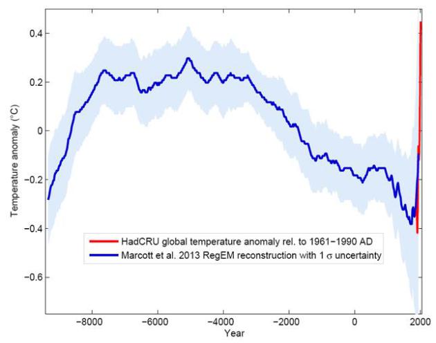
Temperature Chart For The Last 11,000 Years. Here's an excerpt from a post at
kottke.org: "
For the first time, researchers have put together all the climate data they have (from ice cores, coral, sediment drilling) into one chart
that shows the "global temperature reconstruction for the last 11,000
years" The climate curve looks like a "hump". At the beginning of the
Holocene - after the end of the last Ice Age - global temperature
increased, and subsequently it decreased again by 0.7 ° C over the past
5000 years. The well-known transition from the relatively warm Medieval
into the "little ice age" turns out to be part of a much longer-term
cooling, which ended abruptly with the rapid warming of the 20th
Century. Within a hundred years, the cooling of the previous 5000 years
was undone..."
Environmental Consequences Of Fracking.
If you're interested in learning more about fracking and the impact on
the environment I encourage you to attend this evening's meeting of the
Minnehaha Chapter of the Izaak Walton League
at 7 PM this evening. The presenter is Matt Norton, Campaign Director
at the Minnesota Environmental Partnership (MEP). The location:
Linden Hills Recreation Center, 3100 West 43rd Street, Minneapolis, Minnesota 55408.
Encouraging Results Seen In First Nationwide Look At Gas Leaks From Drilling Boom.
There are still many unanswered questions about the long-term
environmental safety of hydraulic fracture, or "fracking", including
possible negative impacts on groundwater and a potential link between
injecting water and chemicals deep underground, as well as a rash of
recent (small) earth tremors near drilling sites. But recent papers
suggest methane leakage from fracking may not be as bad as previously
thought. The jury is still out, but the process is still considerably
cleaner than coal. Here's an excerpt of an Andrew Revkin post at
The New York Time's Dot Earth: "...
The
analysis, led by David T. Allen and other energy and environment
researchers at the University of Texas, finds that estimates of methane
escaping from gas drilling made by the Environmental Protection Agency
are fairly accurate, over all, while those from industry critics and
some indirect studies of leakage (from aerial measurements, for example) appear far too high. A comprehensive package of background on the research has been posted by the university. While the researchers found that emissions from a critical stage of well construction — “completions”
— are far lower than regulators had estimated, they pinpointed an
important under-appreciated source of escaping gas — pneumatic devices
powered by the pressure of the extracted natural gas..."
The 5 Stages Of Climate Denial Are On Display Ahead Of The IPCC Report.
The Guardian has the story - here's a clip: "...
Just in the past week we've seen:
Interestingly, these pieces spanned nearly the full spectrum of the 5 stages of global warming denial.
Stage 1: Deny the Problem Exists
Often
when people are first faced with an inconvenient problem, the immediate
reaction involves denying its existence. For a long time climate
contrarians denied that the planet was warming. Usually this involves
disputing the accuracy of the surface temperature record, given that the
data clearly indicate rapid warming..."


No comments:
Post a Comment