94 F. high Saturday in the Twin Cities.
75 F. average high on September 7.
72 F. high on September 7, 2012.
18 days at or above 90 F. this year in the Twin Cities. Average is 14.
31 days at/above 90 F. in 2012
44 days at/above 90 F. in 1988 (most on record for MSP).
A Baffling Pattern
My official winter prediction is out: "colder with some snow." 100% confidence - take it to the bank.
Note to self: when in doubt be vague.
We're in an ENSO-neutral state in the Pacific,
but I'm seeing a slight trend toward a mild El Nino warming phase, which
may favor a (slightly) warmer winter for the Upper Midwest. The 6-month
outlook is a curiosity - just tell me it's going to rain, Paul.
T-storms may brush much of Minnesota Monday as
overheated air pushes north, but it won't be the sustained soaking we
need. If the sun is out for a few hours we may see mid-90s tomorrow,
with a dew point near 70F. Another "heat day" for area schools?
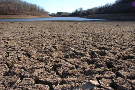
Extreme heat in recent weeks has accelerated
evaporation of water from lakes & fields, accelerating drought. The
3rd week of September brings a better chance of rain. Fingers crossed.
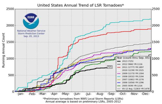
Only 725 tornadoes have touched down on the USA
in 2013; 9 in Minnesota (all EF-0). Only 17 years since 1953 have seen
fewer tornadoes thru August. We may set a new record for the latest
(first) hurricane on record in the Atlantic.
It's too early for complacency. In 2001 the first hurricane formed on Sept. 10. There were 9 hurricanes later that season.
* 500 mb forecast winds aloft, valid 12z this morning, courtesy of
UCAR.
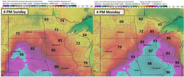
Cooler Sunday - Monday Heat Spike. NAM guidance
shows temperatures at least 10F cooler today than Saturday, in fact
highs hold in the 70s up north. By Monday a storm tracking over northern
Minnesota will yank super-heated air north - a possibility of mid-90s
by late Monday afternoon, even some upper 90s south/west of MSP. Model
data above: Ham Weather.
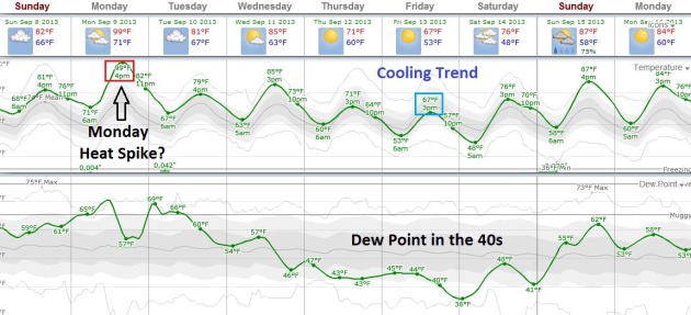
Tropical Monday, Then A Taste Of September. ECMWF
forecast highs (top trend line) and dew points (bottom trend line)
above, courtesy of Weatherspark, shows a high of 99F Monday. I doubt it
will get that hot, but mid-90s seem likely if there's any sun Monday
afternoon. The best chance of a Monday shower or T-shower? Morning
hours, with the best chance of convection over northern MInnesota. We
cool off into the low 70s by Thursday, with cool temperatures and
40-degree dew points spilling over into Saturday.
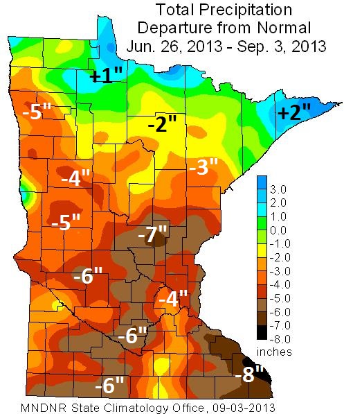
Rainfall Departure From Normal: June 26 - September 3.
The greatest rainfall deficit is showing up over far southeastern
Minnesota, over 8" below normal from near Lake City to Winona. Much of
southwest and central Minnesota is running a 6-7" rainfall shortage
since late June, only far northern counties above average in the
rainfall department. Source: MN DNR and the
Minnesota Climatology Working Group.
Summer Hangs Tough. Dry, desert air is pushing
across the Plains into the Upper Midwest by Monday, sparking a few
showers and T-storms from the Dakotas into the Great Lakes. Monsoon
T-storms flare up over the southwestern USA, while another cool front
pushes into New England - fairly dry weather over much of the South.
84-hour NAM: NOAA.
September Starts Cool And Dry. Here's an excerpt from Dr. Mark Seeley's latest edition of
WeatherTalk: "...
Rainfall
deficits continue to mount in many parts of the state. The U.S.
Drought Monitor now shows that over 53 percent of the state landscape
is in moderate to severe drought. Severe drought is now designated for
parts of Stearns, Sherburne, Benton, Wright, Meeker, and Kandiyohi
Counties in central Minnesota. These counties and others had been
drought-free since mid-May. Volume flow on many Minnesota watersheds is
down as well, in some cases well below average for this time of year.
Unfortunately the outlook favors warm and dry weather through the
third week of September for most of the state...."
Warm Weather Keeps Pools Open Longer, But Hits Farms With Extreme Drought. Here's a clip from a story at
The Star Tribune: ...“
It’s
a bit disconcerting,” said University of Minnesota Extension
climatologist Mark Seeley. “That’s pushing them right back into the
predicament they were in last year." In fact, last year’s drought that
hit Minnesota from midsummer into early winter was among the worst in
state history. In April 2012, nearly 98 percent of the state was in
some kind of drought condition A wet later part of winter and spring
alleviated that, but now drought has returned after a streak of little
rainfall and lingering heat. Since July, Seeley said, rainfall for
central Minnesota is 5 to 7 inches short of average, stressing crops.
“They’ve been sucking the water out of soil,” he said..."
"Ask Paul". Weather-related questions, comments (and threats):
Hi Paul,
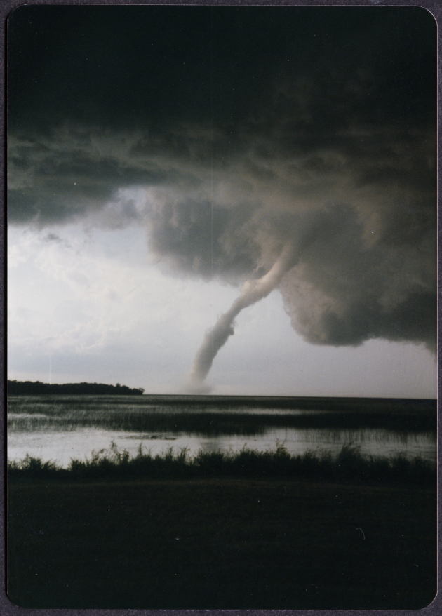
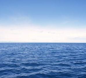
"Is it a fact or a myth that a tornado will skip over a body of
water? Someone told me that they were out in a boat and weren't worried
about a tornado warning because they'd be safe on water. I'm not sure
that's a good idea! Thank you!"
Nancy Hartman, Burnsville
Nancy - your gut is correct. A lake, river (or valley) won't deter a
tornado, especially a large tornado. A tornado is a process, not an
object; the larger dynamics and wind inflow into a severe thunderstorm
drive the intensification or weakening of a funnel, not the surface the
vortex passes over. I've seen numerous instances of a tornado passing
over water, transitioning to a waterspout, then back to tornado as it
passes over land again. Another important point: severe thunderstorms
capable of tornadoes usually produce intense lightning; another reason
you don't want to be on a lake (or beach). Thanks for a great
question/observation.
"Is there a weather club/group in the Twin Cities? I did a Google
search and couldn't find one. This would allow my friend and family a
reprieve as well as enabling me to chat with other weather geeks. Thanks
so much!
Kae Evensen
Kae- A good place to start is the
Twin Cities Chapter of the American Meteorological Society,
which has frequent meetings with interesting topics/guest speakers and a
chance to network with local weather enthusiasts and meteorologists.
Good luck!
Extreme Weather Snoozer: No Hurricanes, And Low Tornado Numbers In 2013. Here's an excerpt of a good overview of the (miraculously quiet) tornado and hurricane season of 2013 from
Capital Weather Gang meteorologist Jason Samenow: "...
Going
back further, a small group of years have been quieter. “There have
been 17 years since 1953 with fewer tornadoes through August than what
we’ve seen reported in 2013,” SPC’s warning coordination meteorologist
Greg Carbin says. “I think it is fair to say that 2013 is in the least
active 25% of all years in the last 62 years.” Of course, the year is
far from over..."
Image credit above: "
Black line is 2013 tornado report tally year to date. Other lines represent other years and 2005-2012 average." (NOAA SPC)
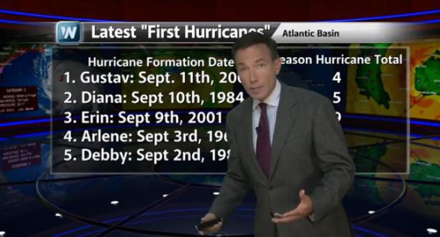
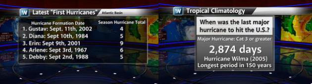
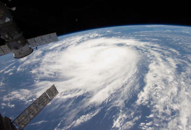
Nearing Record For Latest (First) Hurricane In The Atlantic. Yes, this season may wind up being a dud for hurricanes, but I'm not sure I'd take that bet, not yet. In today's
Climate Matters we look at previous quiet starts to a handful of hurricane seasons that wound up being VERY active: "
Since
record keeping began, the latest the first hurricane has formed in
the Atlantic is September 11th. We're only a few days away from
breaking that record. But just because we haven't seen a hurricane
yet, doesn't mean you should let your guard down. WeatherNation Chief
Meteorologist Paul Douglas shows us how the seasons with late
hurricane starts panned out."
Long Overdue For A (Major) Hurricane. It's been 8
years since America has been struck by a Category 3 or stronger
hurricane (Wilma in 2005). If we go 4 more days without a hurricane
we'll set a new record (for latest-first hurricane in the Atlantic
basin). But it's still early to call the hurricane season a bust. Gustav
formed on September 11, 2002, followed by 3 more hurricanes. Erin
didn't form until September 9, 2001. It was one of 9 hurricanes that
year, 4 of them major Category 3 storms. Graphics: WeatherNation TV.
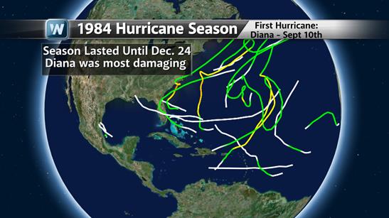
1984. Diana
didn't become a hurricane (first of the season) until September 10th.
That season tropical storms were observed in the Atlantic basin as late
as Christmas Eve. Source: NHC and WeatherNation TV.
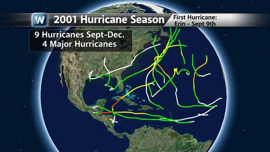
2001.
Hurricane Erin didn't form until September 9, 2001. That season went on
to produce 9 hurricanes in the Atlantic, including 4 Category 3+ storms.
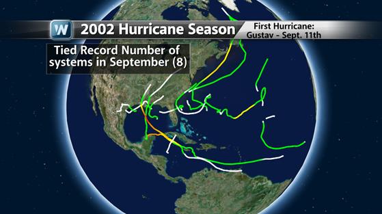
2002. The
first hurricane of the season in 2002 was "Gustav" on September 11. A
total of 8 tropical storms and hurricanes formed between September 11 -
30, 2002. Like flipping on a switch. My point? It's still a bit early to
let our guard down - premature for complacency in Hurricane Alley.
Lackluster Hurricane Season Could Still Rev Up. Yes,
it's amazingly quiet in the tropics, but history teaches us that it
would probably be premature to let our guard down just yet. Here's a
clip from a story at
Live Science: "...
The
lack of hurricanes can be blamed on westerly winds, Weber said. So
far this summer, there have been strong winds blowing from west to east
across the Atlantic, which have systematically destroyed developing
storms and prevented them from strengthening and growing into
well-organized hurricanes,
Weber said. Hurricanes are fueled by the transfer of heat from the
ocean to the upper atmosphere, but they depend on a relatively
symmetrical, rotating system to get going. They form best in calm
conditions, with warm surface temperatures, Weber added. A second,
lesser factor: Dry air and dust have also been blowing westward from
North Africa's Sahel region, hampering development of early season
hurricanes that often form near the Cape Verde Islands in the eastern
Atlantic, Weber said..." (File photo of "Katia" courtesy of NASA).
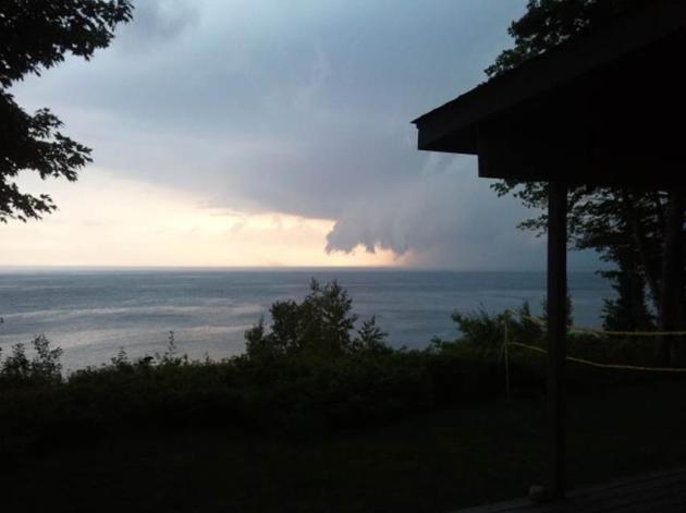
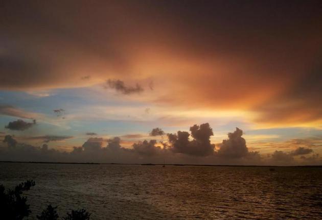
Shelf Cloud. Thanks to Dixie Imholt for passing this one along: "
This
was taken from the South Shore of Madeline Island overlooking Long
Island, where we have a summer home. I grew up in southern Florida and
so have seen lots of spectacular cloud formations, but this was very
unique. It was like a giant claw that just moved across the lake. The
storm approaching us was not nearly as bad on our side of the island (as
foreboding as it looked) but we are on the lee side of the island. The
north side of theisland folks said it was like a hurricane."
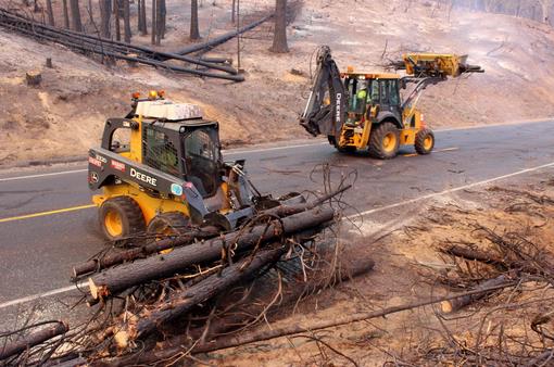
Yosemite Fire, Now California's 3rd Largest, To Intensify - Officials. Here's an update on the Yosemite Rim Fire from
Reuters: "
A
wildfire that has consumed parts of Yosemite National Park and charred
an area greater than the city of Dallas, Texas, is expected to
intensify on Friday and is now California's third largest wildfire on
record, fire managers said. The 20-day Rim Fire, named for the popular
Rim of the World looking, is expected to burn another two weeks, they
added. The blaze has blackened about 246,350 acres (99,694 hectares),
or 385 square miles, of timber and chaparral in the rugged northern
California forests since it broke out on Aug. 17. Fanned by wind in
hot and dry weather, the fire has grown by almost 10,000 acres since
Thursday, although it has stayed mostly within containment lines that
firefighters have drawn around 80 percent of the blaze's permimeter..."
Photo credit above: "
In this photo provided by the U.S.
Forest Service, Crews clear California Highway 120 of debris, as crews
continue to fight the Rim Fire near Yosemite National Park in
California Wednesday, Sept. 4, 2013. The massive wildfire is now 80
percent contained according to a state fire spokesman. The Rim Fire’s
southeast flank in Yosemite National Park is expected to remain active
where unburned fuels remain between containment lines and the fire." (AP Photo/U.S. Forest Service, Mike McMillan).
Cardiovascular Risk Factors Predominant During Cold Winter Months.
Maybe I should have saved this for January, but maybe there's still
time for you to shack up with your good buddy down in Scottsdale or
Sarasota for a few well-timed months. Here's an excerpt from
redOrbit: "
A
new multinational study has linked cardiovascular risk factors to cold
weather. Based on cross-sectional data from 10 studies over seven
countries, researchers found such risk factors occur more in the winter
than in the summer. “Deaths from cardiovascular disease
are higher in winter and lower in summer. We decided to conduct a
large scale study to see whether cardiovascular risk factors have a
seasonal pattern which could explain the seasonality in deaths,” said
Dr. Pedro Marques-Vidal of Institute of Social and Preventive Medicine,
University of Lausanne (IUMSP)..."
9 Questions About Syria You Were Too Embarrassed To Ask.
A bleak topic? Absolutely, but I think I have a better understanding of
just how hopeless the situation really is after reading this Max Fisher
article at
The Washington Post.
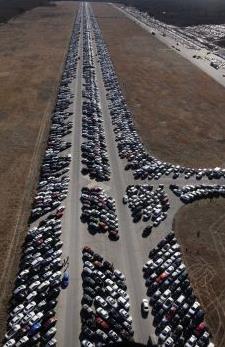
USAA Admits That Some "Totaled" Cars Were Sold. So
that's why I got such a deal on my newest purchase! I was told the car
was "extra-clean", but little did I know... Here's more from
mysanantonio.com: "
USAA
officials now admit that some vehicles it branded as total losses
after being damaged by Hurricane Sandy's floodwaters later were resold
and put back on the road. The San Antonio-based insurer totaled some
4,000 customer vehicles damaged during last year's storm in the
Northeast. USAA earmarked 174 of those vehicles to be sold for parts
only because they had no titles. But USAA later found some buyers who
bought them at auto auctions fraudulently obtained clean titles with
the intention of putting them on the road again...."
Photo credit above: AP. "
This file photo shows thousands
of cars that were damaged in Superstorm Sandy and stored on the runways
at Calverton Executive Airpark in Calverton, N.Y. USAA totaled some
4,000 customer vehicles that had been damaged, but officials for the
San Antonio-based insurer now admit that some vehicles that had been
totaled instead were resold and put back on the road. USAA had
earmarked 174 vehicles to be sold for parts only, but has found that
some were fraudulently given clean titles."
The 147 Companies That Control Everything. Here's an excerpt from a story at
Forbes: "
Three systems theorists at the Swiss Federal Institute of Technology in Zurich
have taken a database listing 37 million companies and investors
worldwide and analyzed all 43,060 transnational corporations and share
ownerships linking them. They built a model of who owns what
and what their revenues are and mapped the whole edifice of economic
power. They discovered that global corporate control has a distinct
bow-tie shape, with a dominant core of 147 firms radiating out from the
middle. Each of these 147 own interlocking stakes of one another and
together they control 40% of the wealth in the network..."
Graphic credit above: "
Visualizing the "super entity." Courtesy: New Scientist.
Visual Mental Health Break. Check out this remarkable video from
Gizmodo: "
When
was the last time you spent your afternoon in a field watching the
clouds pass? Your answer is about to be, "why just now, thank you" after
viewing Suishu Ikeda's mesmerizing time-lapses of Japan's summer skies."
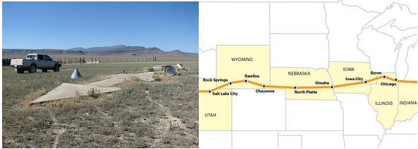
These Really Exist: Giant Concrete Arrows That Point Your Way Across America. My father forwarded this to me, a fascinating tale from Conde Nast Travelers; here's a snippet: "...
On
August 20, 1920, the United States opened its first coast-to-coast
airmail delivery route, just 60 years after the Pony Express closed up
shop. There were no good aviation charts in those days, so pilots had
to eyeball their way across the country using landmarks. This meant
that flying in bad weather was difficult, and night flying was just
about impossible. The Postal Service solved the problem with the world’s
first ground-based civilian navigation system: a series of lit beacons
that would extend from New York to San Francisco. Every ten miles,
pilots would pass a bright yellow concrete arrow..."
Why Do Our Best Ideas Come To Us In The Shower? Hmmm. Bathroom shower? Rain shower? Bridal shower? I'm so confused, but
Mental Floss takes us the heart of the matter: "...
Research shows
you’re more likely to have a creative epiphany when you’re doing
something monotonous, like fishing, exercising, or showering. Since
these routines don’t require much thought, you flip to autopilot. This
frees up your unconscious to work on something else. Your mind goes
wandering, leaving your brain to quietly play a no-holds-barred game of
free association. This kind of daydreaming
relaxes the prefrontal cortex—the brain’s command center for
decisions, goals, and behavior. It also switches on the rest of your
brain’s “default mode network” (DMN) clearing the pathways that connect
different regions of your noggin. With your cortex loosened up and
your DMN switched on, you can make new, creative connections that your
conscious mind would have dismissed...
Betty White, "Breaking Bad" Earn Guiness World Records Titles. Here's an excerpt from NBC's
The Today Show: "
Betty
White has had a career for the record books, and finally, it’s
getting officially acknowledged: The 2014 edition of the "Guinness
World Records" book will now list the 91-year-old comedian and actress
as the record-holder for Longest TV Career for an Entertainer
(Female)....White was in good company among other record holders from
the world of pop culture this year; AMC's "Breaking Bad" will be listed
in the new "Guinness" as the Highest-Rated TV Series, thanks to a metascore of 99 out of 100 on MetaCritic.com..."
TODAY: Comfortable sunshine. Dew point: 57 Winds: E 10-15. High: 81
SUNDAY NIGHT: Clouds increase, very slight thunder chance late. Low: 65
MONDAY: Heat spike. AM shower or T-storm possible. Hazy sun, very hot winds. Dew point: 68. High: 96
TUESDAY: Early shower, then partial clearing. Wake-up: 68. High: 83
WEDNESDAY: Warm sun, less humidity. Dew point: 55. Wake-up: 63. High: 84
THURSDAY: Sunny & pleasant. Dew point: 43. Wake-up: 58. High: 77
FRIDAY: Blue sky, feels like September. Wake-up: 50. High: 73
SATURDAY: Showers developing, possible thunder. Wake-up: 48. High: 77
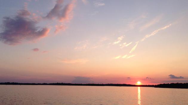
* Photo above courtesy of Gary Teske.
Climate Stories...
"I fear that technology will surpass our human interaction. The world will have a generation of idiots." - Albert Einstein
Most Island Nations Have Yet To Come To Grips With The Possibilities Of Relocation. Greenwire has the story at
eenews.net; here's an excerpt: "....
Climate
change and the response to climate change is not something that you do
this and not the other," Tong said this week. "We in Kiribati are
acknowledging the reality that our land area will be reduced. ... The
question is, then, what do we do? Do we hang onto it? It is our
national strategy to consider both." Grappling with the possibility that
rising sea levels might force island dwellers off their land is one of
the biggest and most existential threats Pacific countries face from
climate change. Yet leaders meeting here for the 44th Pacific Island
Forum say the topic remains so uncomfortable that finding a common
message about climate-induced migration is nearly impossible..."
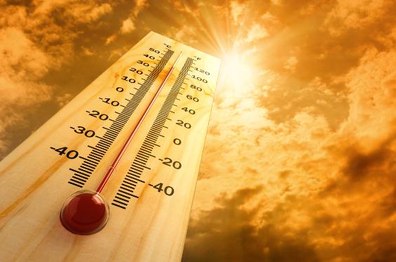
Global Warming Has Increased Risk Of Record Heat, Scientists Say. Phys.org
has the story - here's a clip: "...In the north central and
northeastern United States, extreme weather is more than 4 times as
likely to occur than it was in the pre-industrial era, according to a
new study by Noah Diffenbaugh, a Stanford associate professor of
Environmental Earth System Science, and Martin Scherer, a research
assistant in the department....
*
USA Today takes a look at how frequency of extreme heat and coastal flooding have changed in recent decades.
Global Warming Update: Record Heat Is 4 Times More Likely Now Than In Pre-Industrial Times. A slightly different angle on the same story from
Popular Science: "
Here's
your latest global warming update: It's still happening. Intense heat
is now four times more likely to strike in the U.S. than it was in
pre-industrial times, according to a new study
from Stanford University researchers. July 2012 was the hottest month
on record in the lower 48 states, and the summer brought the "most
severe and extensive drought in at least 25 years," according to the USDA.
And it seems summers like last year's are going to become more
commonplace, with 2012-esque temps becoming more likely, specifically in
the north-central and northeastern United States. This study follows
on the heels of a recently leaked draft of an Intergovernmental Panel
of Climate Change report, which noted that scientists believe we are
experiencing more heat waves because of climate change--which yes, we're still sure humans are causing...." (File photo: NOAA).
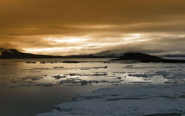
Ice Melting Faster In Greenland, Antarctica In U.N. Leak. The IPCC is about to release another climate update;
Bloomberg Businessweek is running a story with an alleged leak from this upcoming report; here's a clip: "
Ice
in Antarctica and Greenland is disappearing faster and may drive sea
levels higher than predicted this century, according to leaked United
Nations documents. Greenland’s ice added six times more to sea levels
in the decade through 2011 than in the previous 10 years, according to
a draft of the UN’s most comprehensive study on climate change.
Antarctica had a fivefold increase, and the UN is raising its forecast
for how much the two ice sheets will add to Earth’s oceans by 2100.
The changes in the planet’s coldest areas are a “very good indicator”
of a warming planet, according to Walt Meier, a research scientist
with the U.S. National Aeronautics and Space Administration..."


No comments:
Post a Comment