77 F. high in the Twin Cities Sunday.
75 F. average high on September 8.
79 F. high on September 8, 2012.
Trace of rain fell yesterday at MSP International.
Heat Advisory today; combination of mid-90s and a 70-degree dew point will make it feel like 100-104 F. this afternoon.
40s for nighttime lows by late week.
98 F. hottest day of the year so far, on May 14. If it doesn't rain this morning we may come close.
Another "Heat Spike"
Who has endured more 90-degree days this year,
residents of Atlanta or the Twin Cities? If you guessed MSP you are
correct. We've seen 18 days at or above 90F compared with 17 at ATL.
Odd. The heat usually builds gradually, but every now and then we see a
sudden hot spike, a fast-forward northward surge of soul-sapping heat.
We went from a high of 72F May 13 to 98F May 14
(hottest day of the year so far). We'll go from mid-70s yesterday to
mid-90s today; a 1 in 3 shot at 100F from the far south metro to the
Iowa border. Heat Advisories are posted - it may feel like 100-104F by
late afternoon. I'm tempted to cool off in "Hot-lanta". A few T-storms
can't be ruled out, especially over central and northern counties, but
it probably won't be the sustained soaking we need to put a serious dent
in the drought.
And yes, Sunday's forecast was a bust. A dud. A real stinker.
A stormy swirl held together as it pushed out of
the Dakotas, producing significant rain up north; just enough sprinkles
to settle the dust in the metro. With most of Minnesota in moderate to
severe drought it's hard to get indignant about any rain, even on a
Sunday.
Good news: we cool off into the 70s, even some
60-degree highs by late week. Enjoy, because I suspect today won't be
the last 90-degree day of 2013.
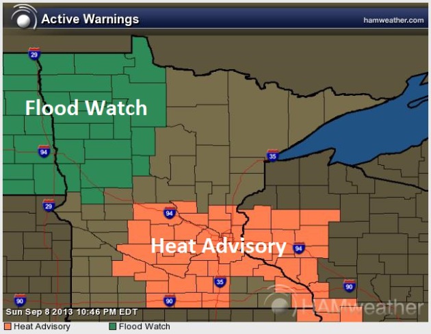
Tropical. Forget September and even August. Today
will feel like something out of mid-July, with highs in the mid to upper
90s over much of southern Minnesota, prompting a Heat Advisory. A swarm
of strong T-storms may drop enough rain in a short period of time for
flash flooding in the Red River Valley. Map: NOAA and Ham Weather.
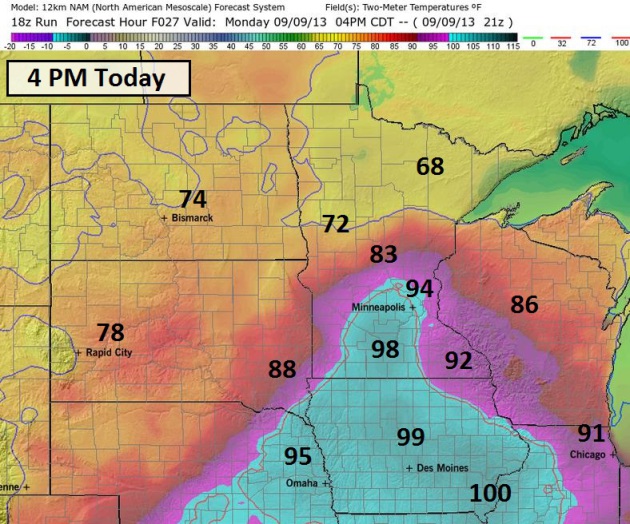
Beastly-Hot.
Models are consistent bring a surge of desert-heat (and tropical dew
points) into southern and central Minnesota later today. The only
complication: morning convection. If T-storms do push across the state
during the morning or midday it will delay the "hot prod", which would
mean low to mid 90s, keeping us a few degrees cooler than we would be
otherwise. But even if that happens dew points will be higher, so the
heat index may be nearly as high (topping 100 by mid-afternoon). 4 pm
NAM forecast above courtesy of Ham Weather.
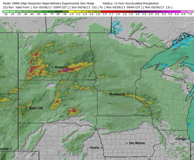
Atmospheric Wild Card.
Today's surge of super-heated air may set off scattered T-storms, with a
chance of an MCS system, a swarm of strong to severe storms capable of
frequent lightning and very heavy rain - something you'd expect to see
in June, not the 9th day of September. HRRR model data shows a potential
for some 1" rains close to the metro, with a few inches over the
Dakotas. I hope this 3 km, 15 hour accumulated rainfall prediction pans
out. Map above: Ham Weather.
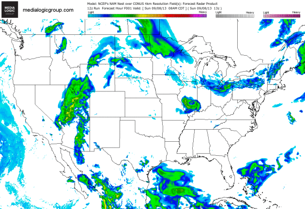
Welcome Rain?
12 km. NAM guidance shows a potential for T-storms today, especially
central and northern Minnesota, but storms may brush the MSP metro area.
The sun should be out by afternoon as temperatures soar into the 90s.
The arrival of slightly cooler air may prolong our shower and thunder
(opportunity) into a portion of Tuesday. Animation sequence: NOAA and
Ham Weather.
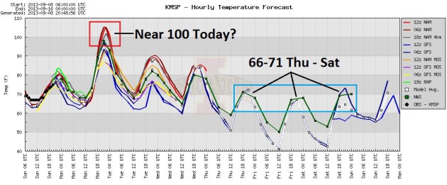
Big Swings. A
few models are predicting 100-degree heat today, which may still happen
IF T-storms fail to develop and the sun is out most of the day, with
southwest winds at 15-25. Relief is brewing; highs in the upper 60s to
near 70 from Thursday into Sunday. Keep shorts and sweatshirts in your
closet until further notice. Graph: Iowa State.
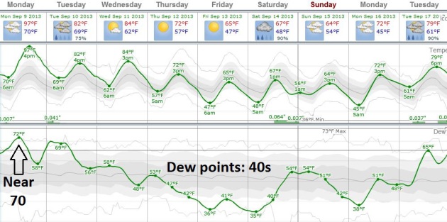
Not For The Faint-Of-Heart.
With a dew point surging above 70F today (especially if rain moistens
the lowest few thousand feet of the atmosphere) the afternoon heat index
should top 100F. Within 72 hours temperatures may be 45-50 F cooler
across much of Minnesota; morning lows dipping into the 40s by late
week, with a welcome drop in dew point. Graph above: weatherspark.com.
Last Hot Front? Don't Bet On It.
The way our expanded summer is going I'm not sure this is our last
outbreak of stuffy air. GFS guidance shows 80s returning between
September 19 and September 22, with a better chance of more significant
rain the last week of September.
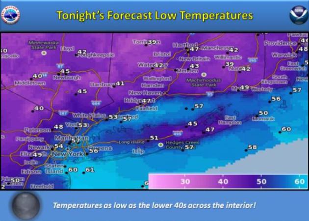
A Chilled Big Apple. Residents of New England are
digging out their jackets and sweatshirts, buzzing about "an early
autumn". Right. A far cry from the central USA.
The New York office of the NWS is predicting wake-up temperatures in the low and mid 40s away from the city and coast.
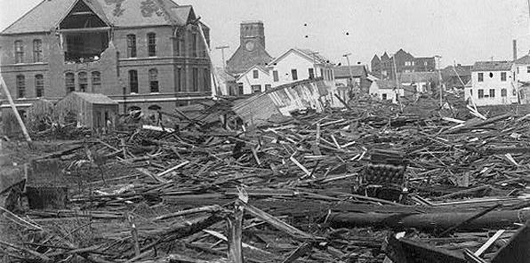
The Galveston Hurricane Of 1900. The anniversary was
yesterday - as much as I want to believe that satellites, Doppler and
supercomputers have lessened the risk of a catastrophe of this scale,
there's no reason for complacency when it comes to major hurricanes
approaching heavily populated areas. Here's a clip from
NOAA's National Ocean Service: "
In
the summer of 1900, Galveston, Texas, was a thriving commercial city
perched on a low-lying barrier island between the Gulf of Mexico and the
Texas mainland. It was an economic boom-town, a major port with over
40,000 inhabitants. End-of-summer tourists flocked to the wide beaches
with sweeping vistas of the Gulf of Mexico. But on September 8, 1900, a horrific hurricane slammed into the city. Wind speeds surpassed 135 miles per hour, making it a category 4 on the Saffir-Simpson Hurricane Wind Scale.
Storm surges rose 15 feet and, within hours, estimates of 6,000 to
12,000 unwary people were killed and over 3,600 buildings were
destroyed. The Galveston Hurricane remains the deadliest natural
disaster in United States history. Although Galveston was rebuilt, it
never reestablished itself as the major port of call it once was. The
city was soon overshadowed by Houston, some miles inland and connected
to the Gulf of Mexico by a canal..."
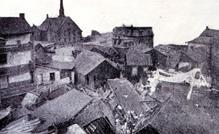
Photo credit above: "
A view of the devastation caused by
the Great Galveston Hurricane of 1900. The destruction wrought by the
hurricane brought forth a new focus on the study of hurricane
prediction." (Library of Congress)
The Great Galveston Hurricane Of 1900. This is still the greatest loss of U.S. lives from a single storm.
NOAA Magazine has a slightly different perspective recapping this amazing display of hubris and nature at its worst; here's a clip: "...
By
the turn of the century, Galveston’s population approached 40,000
and it seemed destined to become one of the biggest and most important
cities along the Gulf Coast. Destiny, however, can be a capricious
mistress, a fact that would become painfully clear on September 8,
1900. On that fateful day, the Great Galveston Hurricane roared
ashore, devastating the island city with winds of 130 to 140 miles per
hour and a storm surge in excess of 15 feet. When its fury finally
abated, at least 8,000 people were dead, 3,600 buildings were
destroyed, and damage estimates exceeded $20 million ($700 million in
today’s dollars). To this day, the 1900 Galveston hurricane remains
the deadliest natural disaster in the nation’s history..."
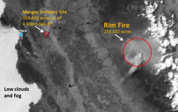
Rim Fire From Space. Tracking two fires from space,
one fairly modest just east of the Bay Area, the plume from the Rim Fire
at Yosemite still massive. Here's a tweet from The San Francisco Bay
Area National Weather Service and
ow.ly.
Scientists Assess Damage From Yosemite-Area Fire. Here's the latest from
usnews.com: "
Scientists
are assessing the damage from a massive wildfire burning around
Yosemite National Park, laying plans to protect habitat and waterways
as the fall rainy season approaches. Members of the federal Burned Area
Emergency Response team were hiking the rugged Sierra Nevada terrain
Saturday even as thousands of firefighters still were battling the
four-week-old blaze, now the third-largest wildfire in modern
California history. Federal officials have amassed a team of 50
scientists, more than twice what is usually deployed to assess wildfire
damage. With so many people assigned to the job, they hope to have a
preliminary report ready in two weeks so remediation can start before
the first storms, Alex Janicki, the Stanislaus National Forest BAER
response coordinator, said..."
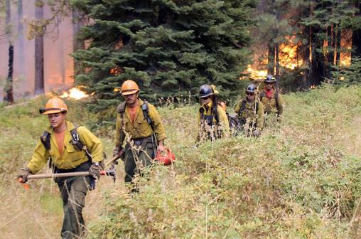
Photo credit above: "
In this photo provided by the U.S.
Forest Service, members of the Horseshoe Meadow Interagency Hotshot
Crew, from Miramonte, Calif., walk near a controlled burn operation as
they fight the Rim Fire near Yosemite National Park in California
Sunday, Sept. 1, 2013. The massive wildfire is now 75 percent contained
according to a state fire spokesman." (AP Photo/U.S. Forest Service, Mike McMillan).
Rim Fire Plume. Here's a high-resolution of the
smoke plume from the Yosemite Rim Fire, the 3rd largest in California
history, from YumaNet.com and
Twitter.
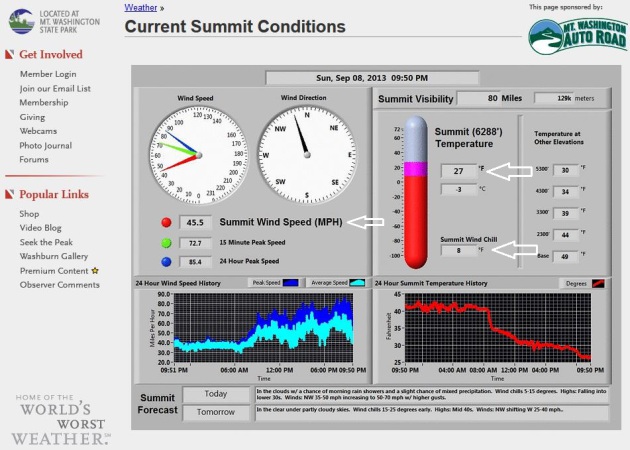
The World's Worst Weather! Yes, the summit of Mt.
Washington, New Hampshire is certainly in the running for that great
honor. It makes Minnesota look like Club Med. I grabbed this image
Sunday evening, when the air temperature at the
Weather Observatory was a crisp 27F with sustained winds of 45.5 mph, creating a chill factor of +8F. Lovely.
Chronic Exposure To Air Pollution Linked With Heart Disease, Lung Cancer. Here's an excerpt from a story at
Nature World News: "
Researchers
have found that long-time exposure to ozone, a greenhouse gas
prevalent in urban areas, can raise the risk of cardiovascular disease.
The study was conducted by researchers at the University of
California, Berkeley and colleagues who also found a strong association
between nitrogen dioxide and an increased risk of death from lung
cancer. This isn't the first study to link health complications
withrising levels of air pollution; a related study had found that
annually two million people die due to air pollution.
Previous research by scientists at MIT also found that more people in
the U.K. die from air pollution than road accidents. This study
appeared in the journal Environment Science and Technology..."
Photo credit above: REUTERS/Lucy Nicholson.
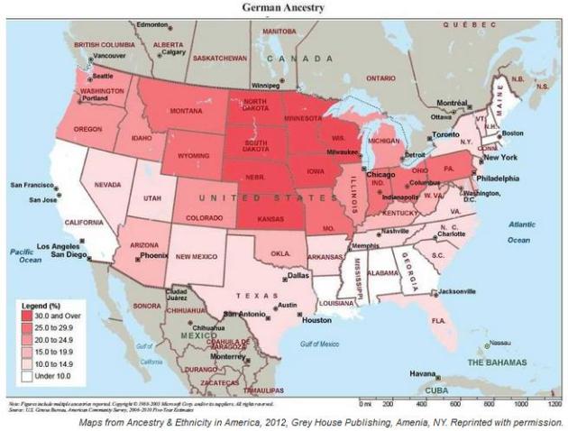
26 Maps That Show How Ethnic Groups Are Divided Across America. This was interesting - a clip from a story at
Business Insider: "
The United States may be a melting pot, but many ancestry groups
still stick together. Take German-Americans, the country's largest
ancestry group with 49 million members. While they make up more than
30% of the population in the Midwest, they account
for less than 10% of the population in the Deep South and
California....Maps of the largest ancestry and racial groups in America
based on the American Community Survey can be found in a book called "Ancestry & Ethnicity in America." With permission from Grey House Publishing, we're posting them here..."
Our Cultural Addiction To Phones, In One Disconcerting Video.
Yes, this hits close to home. From concerts to birthday parties to a
simple sunset - it's hard for some of us to just experience something
(nice). We feel like we have to capture it on our "smartphones",
memorialize it - immortalize it. So much for living in the moment.
Here's a great video from
NPR: "
The
cultural shift is complete. We're all just alone with our smartphones,
even when we're surrounded by other humans. The extent of our obsession
with capturing every moment instead of merely just experiencing them
is highlighted in the viral short film, . It's now at nearly 20 million
views and if you haven't seen it, you must have gone without your phone
too long. — who wrote and stars in the film — shows scenes that can hit
too close to home, saying something about how we often use technology
at the expense of forging real, human connections..."
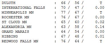
Busted Forecast.
"Where was the sun, Paul?" Great question. It was still there, we just
couldn't see it with all the thick clouds and spotty showers. What
happened? Showers and T-storms fired up over the Dakotas, and instead of
weakening (like the models were suggesting) they pushed all the way
across Minnesota, with heaviest rains up north. Brainerd got soaked with
.67" rain yesterday, but only .02" fell at St. Cloud, .14" for
Alexandria. Clouds and showers kep temperatuers in the 60s over much of
central and northern Minnesota.
TODAY: Heat Advisory. Chance of AM T-storms. Hot PM sunshine likely. Dew point: 70. Feels like 100+. Winds: S/SW 15-25. High: 96
MONDAY NIGHT: Warm and sultry. Low: 69
TUESDAY: Stray shower or T-shower. Not as hot. High: 82
WEDNESDAY: Sunny, less humidity. Dew point: 55. Wake-up: 67. High: 83
THURSDAY: Blue sky, comfortable again. Dew point: 47. Wake-up: 58. High: 74
FRIDAY: Light jackets at the bus stop? Sunny, feels like late September. Wake-up: 48. High: 69
SATURDAY: Cloudy, chance of rain. Wake-up: 49. High: 68
SUNDAY: Damp start, then slow clearing. Wake-up: 54. High: 67
Climate Stories...
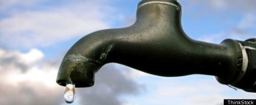
In California, Silent Water War Fought Underground As Farms And Cities Compete For Groundwater. One
of the big environmental themes of the 21st century will be access to
clear, reliable water supplies, especially over the western half of the
USA. Here's an excerpt from a story at
The Washington Post: "...
Fresno
is just one player in a water war that’s quietly being fought
underground. Throughout the Central Valley — one of the world’s most
productive agricultural regions — farmers, residents and cities have
seen their wells go dry. Those who can afford it have drilled deeper
wells that can cost hundreds of thousands of dollars. Experts say water
supplies have been strained by growing city populations and massive
tracts of newly planted orchards and vineyards. “Water levels are
dropping dramatically in some areas. It’s never been this bad,” said
Steve Arthur, vice president of Arthur and Orum Well Drilling..."
Image credit: ThinkStock.
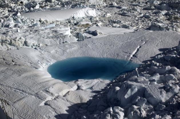
Climate Change Will Turn Greenland Green. Talk about
the first original case of false advertising: "Green Land"? Right.
Here's an excerpt from a story at Smithsonian and
Salon: "...
According to the Icelandic Sagas,
Eric the Red–exiled from Iceland for the crime of murder–stumbled upon
Greenland’s glacial shores in the late 10th century. Though “Coldland”
or “Snowyland” would have been more apt, he dubbed the place
“Grœnland” in the hopes of luring settlers to the remote outpost with
the promise of bountiful forests and fields. Eric the Red’s false
advertising, however, may become more appropriate in the not-too-distant
future, an international team of researchers report in
the journal Philosophical Transactions of the Royal Society B. Climate
change is quickly converting once-frozen tracts into potentially
hospitable places for trees and shrubs. In some parts of the country,
pieces of land have already opened up and only await a few chance seeds
to blow in and begin the process of converting the rugged landscape
into lush forest...."
Photo credit:
AP/Brennan Linsley.
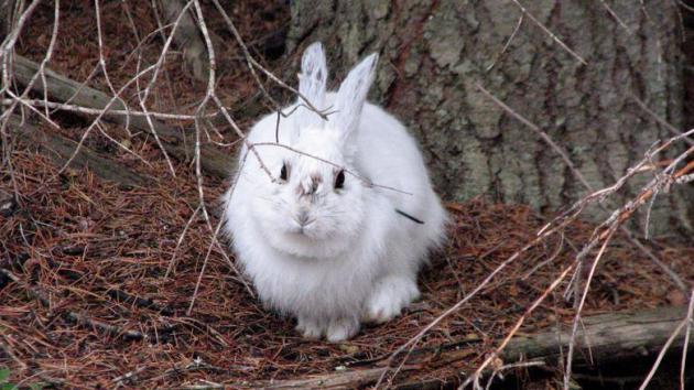
Climate Change Leaves Hare Wearing The Wrong Colors. Snow is on the ground for less of the year in the Rockies, and that has implications, as explained in this
NPR story - here's a clip: "
The
effects of climate change often happen on a large scale, like drought
or a rise in sea level. In the hills outside Missoula, Mont., wildlife
biologists are looking at a change to something very small: the
snowshoe hare. Life as snowshoe hare is pretty stressful. For one,
almost everything in the forest wants to eat you. Alex Kumar, a graduate
student at the University of Montana, lists the animals that are hungry
for hares. "Lynx, foxes, coyotes, raptors, birds of prey.
Interestingly enough, young hares, their main predator is actually red
squirrels..."
Photo credit above: "
A white snowshoe hare against a brown background makes the animal easy prey.
" L.S. Mills Research Photo.


No comments:
Post a Comment