68 F. high in the Twin Cities Monday. Clouds lingered longer, keeping us a few degrees cooler than predicted.
77 F. average high on September 2.
88 F. high on September 2, 2012.
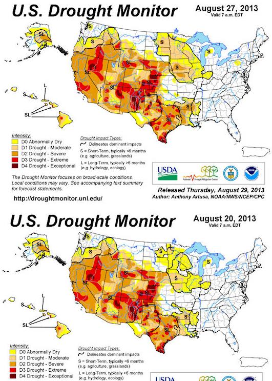
55% of Minnesota now in moderate drought - includes Twin Cities metro.
90+ F heat returns by Friday and Saturday
No rain until next Sunday/Monday at the earliest.
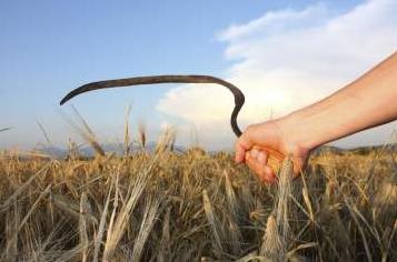
"Flash Drought"
New phrases are popping up in our weather
lexicon to describe weather-on-steroids: polar amplification, a "lazy
jet", heat spikes, 3-sigma flash floods, and now, "flash droughts".
That's how the sudden onset of drought is being described from Minnesota to Missouri.
We went from a late planting season to heavy
June rains (crops put down shallow roots) to unusual chill mid-summer,
to precious little rain in August. Instant drought.
In one week Minnesota went from 10 percent to 55 percent drought. I've never seen that before.
Why? Great question. Data is still inconclusive,
but I suspect it has something to do with rapid warming at high
latitudes and record melting of Arctic ice in 2012.
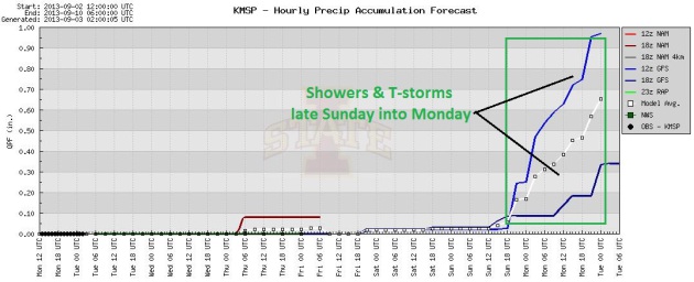
Enjoy the free A/C because models are still
hinting at low 90s by the end of the week; showers and T-storms helping
to settle the dust late Sunday into Monday night.
August rain came in one 2 inch, two-day deluge
on the 5th & 6th. Since then we've seen nearly a month of little or
no rain, with soaking storms tracking over northern Minnesota.
Which makes one wonder: is our pattern of
extra-wet late springs & extra-dry late summers a fluke - or a
trend? I guess we'll find out. Stay tuned.
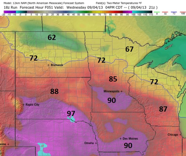
Rerun Of Summer By Wednesday. 4
km. NAM data suggests a high in the mid-80s Wednesday, maybe upper 80s
to near 90 from Mankato to Windom. Hotter air surges north by Friday and
Saturday with a shot at 90 F. both days. Map above: Ham Weather.
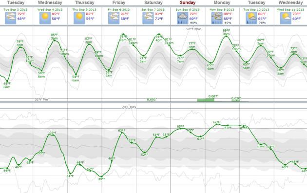
Premature To Retire The Shorts.
I don't see any true cold fronts right around the corner, in fact
temperatures will probably trend well above average the next 2 weeks.
After a reprieve from the hot & stickies, dew points rise to near
60F Wedneday, maybe upper 60s to near 70F from Friday into Tuesday
morning. Temperature (top) and dew point (bottom) predictions using
ECMWF data, courtesy of Weatherspark.
When In A Drought - Don't Forecast Rain.
Once again most of Minnesota is in a moderate drought, including the
Twin Cities metro area. I don't see any rain until late Sunday into
Monday, when (fickle) T-storms may once again push across the state.
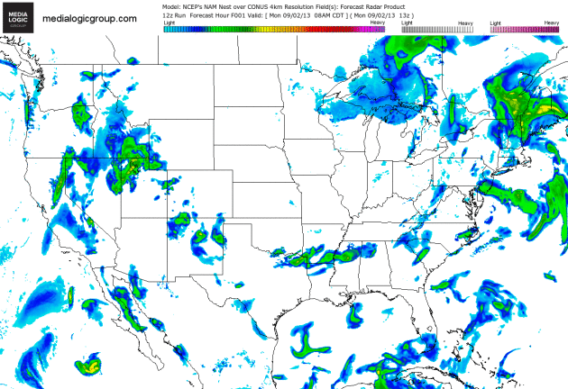
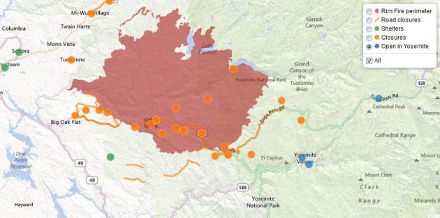
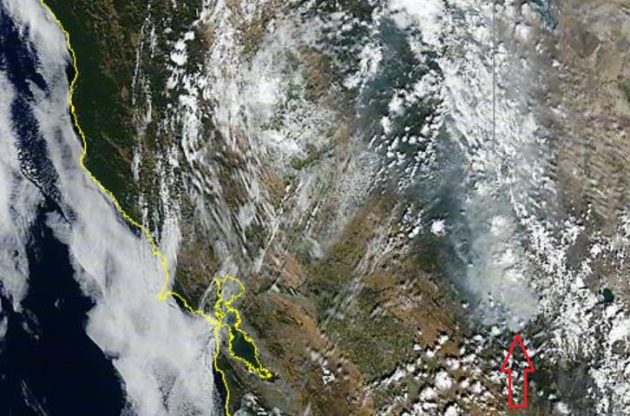
60-Hour Future Radar. Here are
predicted rainfall patterns looking out into Wednesday night, more
instability showers and T-storms for New England, a surge of rain
pushing northward up the Sierra Nevada, helping firefighters battling
the Rim Fire at Yosemite. 4 km. NAM Forecast Radar courtesy of Ham
Weather.
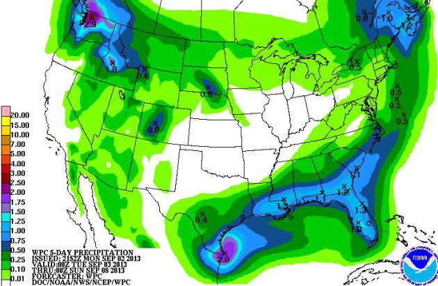
Spotty 5-Day Rainfall Amounts.
NOAA HPC is predicting some 1-2" rainfall amounts along the Gulf Coast,
and from Boise to Seattle (where nearly 3" of rain may fall). The
nation's midsection remains dry, New England drying out by midweek.
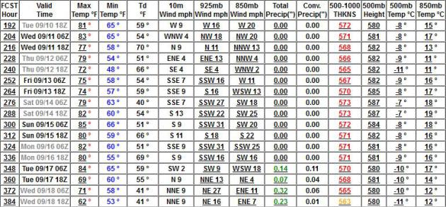
Warmer Than Average Into Third Week of September? GFS
numbers are out, and they show a warm bias thru at least September 17,
with highs mostly in the 80s through the period. It also looks very dry
from September 10 - 16, with a better chance of more significant
rain/storms after September 17.
Flash Drought: New Term Coined To Describe Summer's Strange Weather. I thought this article from
LaCrosseTribune.com
captured the moisture (and temperature) whiplash we've experienced
this summer: too much moisture early in the planting season, far too
little by August, with huge swings in temperature accompanying these
meteorological flip-flops. Here's an excerpt: "
The region’s mood
swing from cool, soggy spring to parched yet sweltering late summer has
coined a new weather term: flash drought. The label reflects how
quickly conditions have deteriorated in the region under the withering
combination of weeks without rain coupled with extreme heat at a
crucial time for maturing crops, said Todd Shea, a meteorologist with
the National Weather Service in La Crosse....This quick-onset drought
also comes in a year in which crops that otherwise might have endured
the dry spell already were delayed by, ironically, too much rain that
pushed planting in some fields until mid- to late June. “It’s been a
year that’s not been like any in recent memory,” Steve Huntzicker, in
his eighth year as La Crosse County UW-Extension agricultural agent,
said of the conditions...."
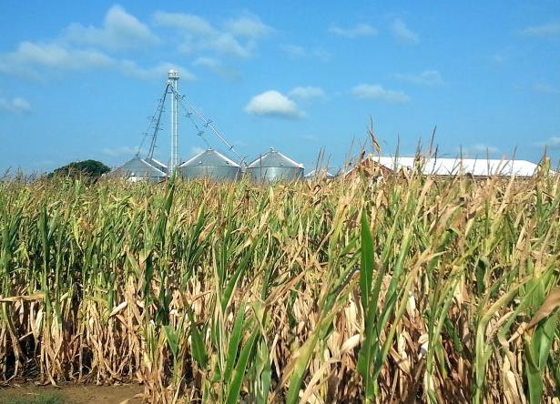
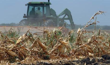
Photo credit: Chris Hardie. "
A cornfield near Ettrick show signs of stress from the recent drought."
Midwest Dryness Intensifies; Plains Drought Sustained.
Farm Futures has more on the sudden onset of moderate drought across much of the state: "
Higher
than normal temperatures coupled with minimal rainfall has kept the
Midwest in a "flash drought" late in the summer season, the latest U.S. Drought Monitor
reports, while rain the Plains continues to be minimal. Rapid onset of
heat and diminishing soil moisture is taking a toll on Midwestern
crops, however, regional waterways are not yet showing much impact.
According to the USGS, approximately three-quarters of Midwestern
stream flows are close to normal for this time of year, with most of
the remainder registering as below-normal, the Drought Monitor reports.
The dryness is in stark contrast to the wet spring many areas of the
Midwest experienced; for example, Burlington, Iowa, this year had its
wettest spring on record since 1898, with 19.23 inches of
precipitation. Burlington is now on track to experience its driest
summer on record since 1898, with only 3.86 inches of precipitation so
far..."
Much Of Northern Missouri Experiencing Flash Drought. The phrase is popping up more and more in recent days; here's a clip from
kspr.com in Springfield, MO: "
Parts
of southern Missouri experienced flash flooding this past month. Now
parts of northern Missouri are in a flash drought. That's the phrase
being used to describe the sudden onset of drought conditions due to a
spike in hot, dry, sunny days with low humidity..."
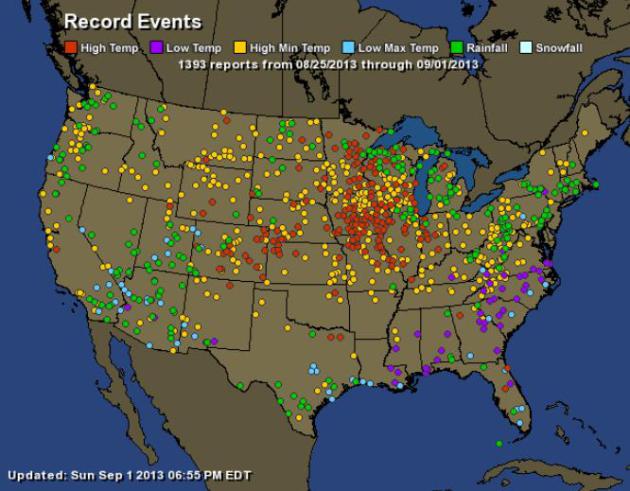
Big Extremes For Late August. NOAA data shows the
focus on record heat last week over the Midwest, with (fewer) record
lows over the southern USA. Green dots are 24 hour rainfall records over
the last 7 days. More details from
Ham Weather:
| Total Records: |
1393 |
| Rainfall: |
245 |
| High Temp: |
244 |
| Low Temp: |
63 |
| Low Max Temp: |
84 |
| High Min Temp: |
757 |
Yosemite Fire. What Are California's Largest Fires? The Los Angeles Times has a run-down on the biggest blazes. The Rim/Yosemite Fire is the fourth largest on record for California: "
The
Rim fire has burned its way into the history books, becoming the
fourth-largest wildfire in California history, according to the
California Department of Forestry and Fire Protection. Crews are
continuing to make progress on the two-week-old wildfire that has
scorched 222,777 acres in and around Yosemite National Park. More
than 5,000 firefighters are battling the blaze, which has so far cost
$60 million in state and federal funds, said U.S. Forest Service
spokesman Trevor Augustino..."
Map credit above: "
This map is based on official fire
mapping sources that show rough footprints of actively burning
wildfires. Perimeter updates take at least several hours to produce and
may be based on satellite heat detection, which is approximate.
Zooming into specific locations may produce misleading information. The
Times map requires manual updates, which may be intermittent, so
people in need of urgent information about road closures and
evacuations are advised to keep abreast of communications from fire
officials." Sources: U.S. Forest Service, Inciweb, Geomac, Yosemite National Park. Raoul Ranoa/Los Angeles Times.
Sierra Wildfire Now California's Fourth-Largest. Here's an update from
UTSanDiego.com: "
The
wildfire burning in and around Yosemite National Park has become the
fourth-largest conflagration in modern California history, fire
officials said Sunday as clouds and higher humidity helped crews further
contain the biggest blaze in the United States this year. The
2-week-old Rim Fire moved up a spot on the state's list of large
wildfires dating back to 1932 when it grew to 348 square miles - an area
larger than the cities of San Francisco, Oakland and San Jose
combined - on Saturday, California Department of Forestry and Fire
Protection spokesman Daniel Berlant said. Although the fire still is
growing, it was 40 percent contained as of Sunday, up from 35 percent a
day earlier..."
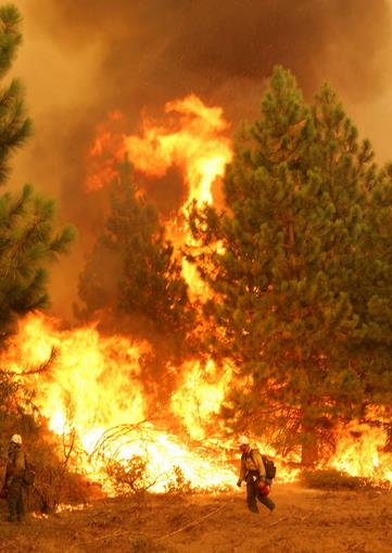
Photo credit above: "
In this Friday, Aug. 30, 2013 photo
provided by the U.S. Forest Service, a member of the Bureau of Land
Management Silver State Hotshot crew from Elko, Nevada, stands by a
burn operation on the southern flank of the Rim Fire near Yosemite
National Park in California. The wildfire burning in and around Yosemite
National Park has become the fourth-largest conflagration in
California history." (AP Photo/U.S. Forest Service, Mike McMillan)
Possible Marijuana Link To Massive California Wildfire. Here's a new potential angle on how the fire got started that I hadn't seen before, an excerpt of a story at
theSundaily.com: "
Investigators
probing the massive wildfire in Yosemite National Park are looking
into whether an illegal marijuana farm may have triggered the blaze, US
media reports said Saturday. As the vast wildfire continued to rage in
the iconic Californian tourist destination, several reports quoted a
local fire chief who suggested marijuana growers may be to blame. Todd
McNeal, a fire chief in Twain Harte, one of the towns affected by the
219,000-acre (88,630 hectare) inferno, said investigators had not
pinpointed the cause of the blaze. "We don't know the exact cause,"
McNeal was quoted as telling a community meeting. However, he added it
was "highly suspect that there might have been some sort of illicit
grove, a marijuana-grow-type thing." "We know it's human caused. There
was no lightning in the area," he said..."
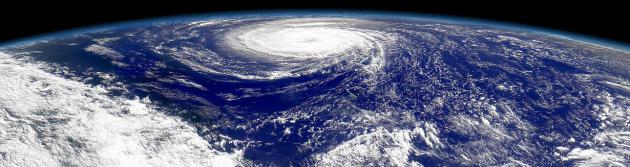
Will Quiet Hurricane Season Stay That Way? I'd be
surprised, but then again I'm continually surprised, pleasantly and
otherwise. Here's some speculation and some good information from
WWL.com in New Orleans: "...
So
far this year we have had six tropical storms, but no hurricanes. Keim
warns, however, that a prevailing weather system that's been deterring
formation over the central Atlantic Ocean may not stick around much
longer. He notes we've seen slow starts and then a barrage of activity
before. "A couple of years ago at this point in the season we had six
named storms and ended up with 19," according to Keim. He says we are
just now entering the "teeth" of the season..."
No Atlantic Hurricane By August In First Time In 11 Years.
The probability of an average or above-average hurricane season in the
Atlantic is dwindling with each passing day. Details from
bloomberg.com: "
August
is about to end without an Atlantic hurricane for the first time since
2002, calling into question predictions of a more active storm season
than normal. Six tropical systems have formed in the Atlantic since the
season began June 1 and none of them has grown to hurricane strength
with winds of at least 74 miles (120 kilometers) per hour. Accumulated
cyclone energy in the Atlantic, a measure of tropical power, is about 30
percent of where it normally would be, said Phil Klotzbach, lead author of Colorado State University’s seasonal hurricane forecasts. “At this point, I doubt that a super-active hurricane season will happen,” Klotzbach said in an e-mail yesterday..."
Spray-On Solar Cells: New, Inexpensive Nanoparticles Lower Solar Cell Manufacturing Costs.
This is the kind of innovation that catches my eye - at some point many
of us will consider supplementing our electricity (from the grid) with
home and business-based solar panels. Costs have dropped nearly 80%
since 2006. Here's an excerpt from
CleanTechnica: "
Relatively
inexpensive, easy-to-manufacture, nanoparticle-based solar cells can
be created with materials that are abundantly common throughout the
Earth’s crust, according to new work from researchers at the University
of Alberta. The new nanoparticle-based solar cells — which could be
mass-manufactured using simple methods, such as roll-to-roll printing
or spray-coating — are possible thanks to a new type of nanoparticle
designed by the researchers. The researchers think that the new
design/discovery — which according to them has been several years in
the making — “is an important step forward in making solar power more
accessible to parts of the world that are off the traditional
electricity grid or face high power costs, such as the Canadian North...”
Photo credit above: "
UAlberta researcher Jillian Buriak
(center) worked with post-doctoral fellows Erik Luber (right) and
Hosnay Mobarok to create nanoparticles that could lead to printable or
spray-on solar cells." Image Credit: University of Alberta
"Walking" Shark Discovered In Indonesia. Chalk
Indonesia off the bucket list. Suddenly the "Land Shark" skits from
SNL don't seem quite so funny - good grief. Here's a clip from
Yahoo News: "
A
new species of shark that "walks" along the seabed using its fins as
tiny legs has been discovered in eastern Indonesia, an environmental
group said Friday. The brown and white bamboo shark pushes itself along
the ocean floor as it forages for small fish and crustaceans at night,
said Conservation International, whose scientists were involved in
its discovery. The shark, which grows to a maximum length of just 80
centimetres (30 inches) and is harmless to humans, was discovered off
Halmahera, one of the Maluku Islands that lie west of New Guinea...."
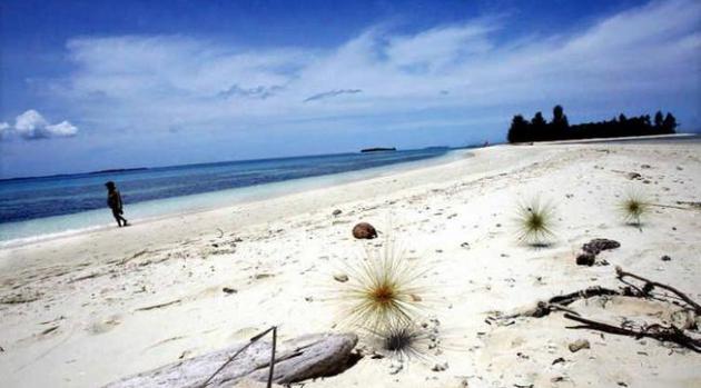
Photo credit above: "
A tourist walks along a white sand
beach in Doloda Island, North Maluku, Indonesia, on August 25, 2006. A
new species of shark that "walks" along the seabed using its fins as
tiny legs has been discovered in eastern Indonesia, an environmental
group said Friday." (AFP Photo/Adek Berry).

TODAY: Sunny & mild. Dew point: 47. Winds: SW 5-10. High: near 80
TUESDAY NIGHT: Clear and comfortable. Low: 59
WEDNESDAY: Warm sun, pleasant (but too dry out there). Dew point: 60. High: 85
THURSDAY: Plenty of sun, a couple degrees cooler. Wake-up: 56. High: 83
FRIDAY: Sunny, heating up again. Dew point: 61. Wake-up: 59. High: near 90
SATURDAY: Hot sun, feels like summer. Dew point: 60. Wake-up: 70. High: 91
SUNDAY: Sticky sun, T-storms late. Dew point: 63. Wake-up: 71. High: 82
MONDAY: Humid, better chance of thunderstorms. Wake-up: 67. High: near 90
Climate Stories...
Kerry Says Climate Change "Irrefutable", "Alarming".
Business Standard has the story - here's the introduction: "
US Secretary of State John Kerry said on Monday the evidence for climate change
was beyond dispute but it was not too late for international action to
prevent its worst impacts. "The science is clear. It is irrefutable and
it is alarming," Kerry told a climate conference in Majuro in the
Marshall Islands in a video address from Washington. "If we continue
down our current path, the impacts of climate change will only get
worse." Kerry said without strong, immediate action, the world would
experience threats to critical infrastructure, regional stability,
public health, economic vitality, and the long-term viability of some
states..."
A Warmer World Will Mean More Pests And Pathogens For Crops.
At first blush a warmer world may have a nice ring, especially in
Minnesota in January, but farmers may not be so pleased over the long
haul. Here's a clip from a story at
Time Science: "...
Pests
and pathogens are weather-dependent, and many thrive in hotter, wetter
climates — which is exactly the sort of change that global warming is
predicted to create over the coming decades. In a new meta-analysis
published in the journal Nature Climate Change, researchers from the
University of Exeter and the University of Oxford looked at how plant
pests and diseases will respond to a warming world, and found that
their range has been steadily shifting toward both poles, as climate
change warms higher latitudes. They found that crop pests have been
spreading north and south a little less than 2 miles (3.2 km) a year
since 1960, though there’s a lot of variety within individual species..."
Photo credit above: AydAn Mutlu.
Climate Change Deniers At War With Military Over Green Energy. Here's an excerpt of a story at
billmoyers.com: "
When Congress returns from vacation in a week and a half, the Senate will take up the National Defense Authorization Act
(NDAA), the bill that sets the Department of Defense (DoD) budget —
and defense-related budgets for other departments — and mandates how
America’s military leaders use that funding. Last year, the fight over
the NDAA got stuck on the Pentagon’s plans to make the military’s
operations greener and more sustainable. Republicans in particular went
after Navy Secretary Ray Mabus’ plan for a “great green fleet”
powered on alternative energy — a play on Theodore Roosevelt’s vision
of a “great white fleet” that would circumnavigate the world and
define the U.S. as a key international player. Mabus’ goal is for his
forces to draw 50 percent of their energy from alternative sources by
2020..."
Photo credit above: "
U.S. Navy officers and sailors stand
at attention as U.S. Navy ship USS Freedom (LCS 1) berths at the
Changi Naval Base on Thursday April 18, 2013 in Singapore." (AP Photo/Wong Maye-E).
Spread Of Global Crop Pests Threatens Global Food Security As World Warms.
EurekAlert has the story - here's an excerpt : "
A
new study has revealed that global warming is resulting in the spread
of crop pests towards the North and South Poles at a rate of nearly 3
km a year. The study, published in the journal Nature Climate Change
and carried out by researchers at the University of Exeter and the
University of Oxford, shows a strong relationship between increased
global temperatures over the past 50 years and expansion in the range of
crop pests. Currently 10-16% of global crop production is lost to
pests. Crop pests include fungi, bacteria, viruses, insects, nematodes,
viroids and oomycetes. The diversity of crop pests continues to
expand and new strains are continually evolving. Losses of major crops
to fungi, and fungi-like microorganisms, amount to enough to feed
nearly nine percent of today's global population. The study suggests
that these figures will increase further if global temperatures
continue to rise as predicted..." (File photo: Star Tribune).
Winding Up The Global Spring Of Planetary Catastrophe.
In a nutshell, we don't know what we don't know. And nature rarely
moves in a perfectly straight line. Tipping points? Unintended
consequences that climate models can't possibly see in advance? We're in
uncharted waters with Earth's climate system, odds are pretty good
things will pop up that we hadn't expected. Here's a clip from
Huffington Post: "
I
was always taught that if you don't know how something works, you
shouldn't mess with it. The Earth's climate represents a wonderfully
complex dynamical system that we do not fully understand. Some
components are in a delicate balance. As we continue to shift that
balance by disrupting our atmosphere's cooling capacity, there is no
telling what will happen...One of the most ominous aspects of global
warming is the apparent "plateau" in global mean surface temperature.
We know from basic physics and from observations that more energy is
entering the earth's atmosphere than is escaping to space. All that
heat is being stored. We don't know exactly where, or what effects it
will have. It's as if we are winding up a giant spring that us
pushing back and giving the appearance of stability that cannot be
real. There is some evidence that the gigantic spring is the Pacific Ocean. Eventually, something is going to give..."


No comments:
Post a Comment