78 F. high in the Twin Cities Tuesday.
77 F. average high on September 3.
92 F. high on September 3, 2012.
90 F. heat possible Friday, Saturday, again Tuesday of next week.
Dry bias continues next 1-2 weeks. Showers and T-storms possible late Sunday into Monday.
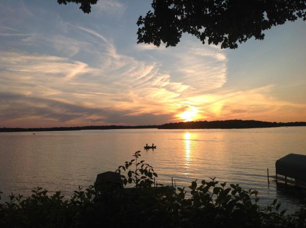
The Mississippi Creek
How dry is it out there? At a Rotary talk
yesterday in St. Cloud SC Times Newspaper Editor John Bodette pulled me
aside. "Have you seen how low the Mississippi is now? People are seeing
rocks and boulders that haven't been visible for decades!" The impact on
river-cooled power plants? We'll see.
No more "threat of storms" or "risk of rain". Now, as it was much of spring, we speculate on the OPPORTUNITY for showers.
State Climate data shows this year's Minnesota
State Fair was the warmest since 1931. Six days above 90F; the third
warmest on record.
My unscientific poll of friends, family members
& complete strangers at Target leads me to believe that 88% of
Minnesotans are just fine with the most recent cool front.
Soak it up, because more heat is building: 90F
highs return by Friday & Saturday. Another 90F high or two is
possible again next week. It's been a strange, chopped-up summer - I'm
not surprised the heat is spilling over into September.
I don't see a drop of rain before Saturday, when
"ridge-rider" T-storms track across northern Minnesota. Monday appears
to have the best likelihood for welcome rain - but I'm seeing a warm,
dry bias into most of September.
* photo credit above: Dave Schwarz, Editor of Photography, St. Cloud Times. "Photo shot on the Mississippi between Becker and Clearwater on Friday, August 23."
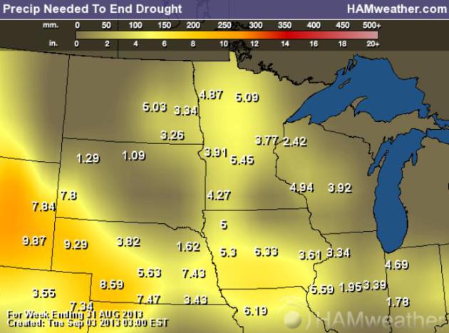
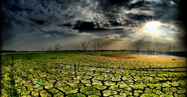
Precipitation Needed To End Drought.
It's deja vu, all over again. Although not as severe as late spring,
moderate drought is now impacting most of Minnesota. NOAA data suggests
3-6" of rain is required to end the drouught across much of Minnesota.
Map above:
Ham Weather.
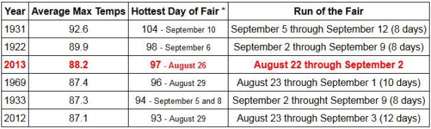
Third Warmest Minnesota State Fair On Record. It was
the warmest state fair since 1931, the most 90-degree days, but third
warmest overall. Accurate data goes back to 1885; here's an excerpt from
the
Minnesota Climatology Working Group: "
The
2013 Minnesota State Fair saw the most 90 degree high temperatures on
record with six as of August 29. There have also been four Minnesota
State Fairs where the temperature was greater than or equal to 90
degrees on five days: 1922, 1931, 1960 and 1991. State Fair dates along
with with Minneapolis/St. Paul Area weather data for those dates can
be found in this table."
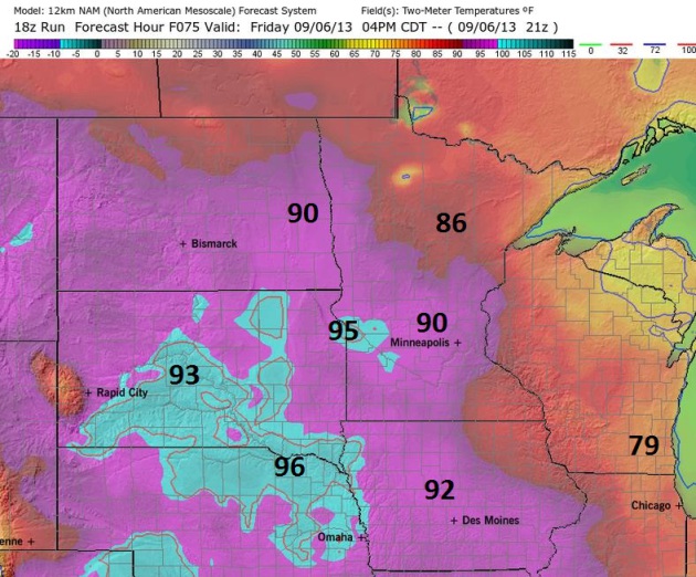 Friday Heat.
 No, not a new action-thriller debuting this fall on TNT, but a prediction, based on (all) model guidance. The 4 km. NAM
model
shows highs near 90F in the metro at 4 pm Friday afternoon, even some
low to mid 90s over west central Minnesota. Don't write summer off just
yet.
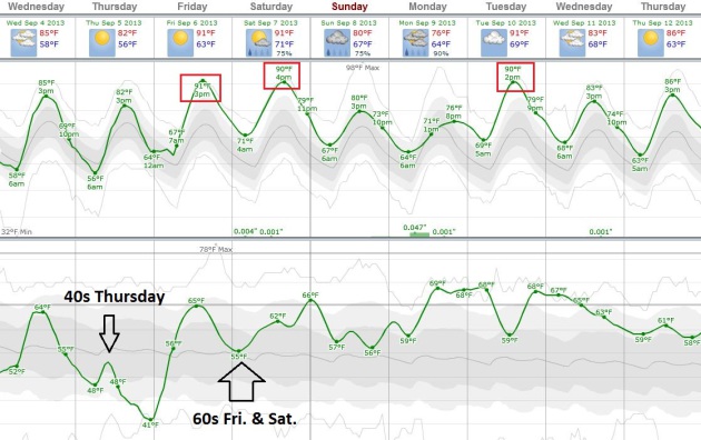
More August Than September. Temperatures and dew
points won't be as high as last week, but the next 7-10 days will be a
poignant reminder that summer warmth isn't done with us just yet. The
best chance of 90F heat: Friday, Saturday, again Tuesday of next week,
but temperatures should average 10-15F. above average into most of next
week. Dew points drop to comfortable levels behind a very weak cool
frontal passage Thursday before returning to the 60s this weekend.
Chart: Weatherspark.

Kayak Fishing Increasingly Popular On Minnesota Waters.
Rapidly falling waters on the Mississippi and other rivers have made
handling a motorboat increasingly treacherous - kayaks are catching on
as a way to navigate the shallow waters, and get closer to the best
fishing. Here's an excerpt from
The St. Cloud Times: "
As
the summer wears on and water levels drop, smallmouth bass anglers see
possibility in every rock and riffle. But those same rocks and
riffles make river fishing difficult, if not impossible, from a
motorboat. Shallow boats and canoes have been used for years in mid to
late summer when the water level drops. Manufacturers now produce
specialized kayaks for fishing shallow waters. Kayak fishing is
catching on in Minnesota, and the shallow, rocky stretch of
Mississippi River from St. Cloud to Monticello is proving to be a
popular spot to try it out..."
Shadow Of A Drought. Some troubling projections focused on the Ogallala Aquifer from this story at
Esquire; here's a clip: "
Our
old friend, the Ogallala Aquifer, which is pretty much what keeps
everything between the Cubs and the Dodgers from being a desert, is
still in trouble. Usually, we stop by to see how they're trying to
finagle our other old friend, the Keystone XL pipeline, through one
slice of it or another. Even without the death-funnel, however, the
aquifer continues to have problems of its own.
"A vast underground lake beneath western Kansas and parts of seven
other states could be mostly depleted by 2060, turning productive
farmland back to semi-arid ground, a new study says.The
life of the Ogallala Aquifer could be extended several decades, but
only if water usage is reduced, a four-year study by researchers from
Kansas State University found. "There is going to be agriculture
production in Kansas and corn production and cattle production really
for the foreseeable future," David Steward, lead author of the study,
said in an interview last week. But without conservation, he said, "the
future is bleak..."
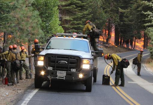
Big Gains On California Wildfire. As of late
afternoon the relative humidity at Yosemite National Park had risen to
65%, winds blowing at only 5 mph. More water in the air and less wind
(spreading fiery embers) has given firefighters a little more breathing
room - in fact they've made significant gains in recent days, as
reported by
Voice of America:
"U.S. firefighters have made gains in battling a massive wildfire in California that is threatening a famous national park. The U.S. Forest Service said Tuesday firefighters have contained 75
percent of the so-called Rim Fire, up from less than 50 percent
contained 36 hours earlier. Cooler temperatures and higher humidity
have helped the nearly 4,400 firefighters battling the blaze on the
edge of Yosemite National Park. The so-called Rim Fire has engulfed
more than 95,000 hectares and covers 953 square kilometers. It has
destroyed more than 100 structures since it started about two weeks
ago. The massive blaze is still some distance from Yosemite National
Park's major attractions, including granite rock formations and
waterfalls. But the wildfire has affected tourism at the park..."
Photo credit above: "
In this photo provided by the U.S.
Forest Service, members of the Roosevelt Interagency Hotshot crew, from
Fort Collins, Colo., gear up for a controlled burn operation as they
fight the Rim Fire near Yosemite National Park in California Sunday,
Sept. 1, 2013. The massive wildfire is now 75 percent contained
according to a state fire spokesman." (AP Photo/U.S. Forest Service, Mike McMillan)
* California using prison inmates to help fight the Rim Fire? Details from
examiner.com.
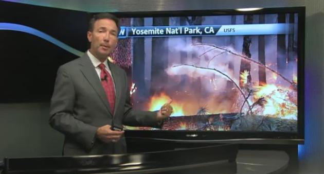
Struck By Extremes: From Flash Flood To Flash Drought.
While 4,000+ firefighters make gains in the Rim Fire, meteorologists
are tracking more moisture extremes east of the Rockies: serious
flooding across portions of New England, while the sudden return of
drought over the Midwest has been called a "flash drought". It's the
speed at which things are happening that is unusual, as described in
today's
Climate Matters: "
WeatherNationTV
Chief Meteorologist Paul Douglas looks at some of the extremes across
the country. Heavy rains have brought flash flooding to the Northeast,
while the drought has expanded into the Midwest."
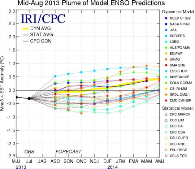
ENSO-Neutral Or Limping Into A Mild El Nino? here
are some of the model forecasts of SST, sea surface temperatures,
showing a bias toward ENSO-neutral in the eastern equatorial Pacific,
possibly even a mild El Nino warming event by spring of 2014. Data:
NOAA NCEP.
Detecting Lightning Is Harder Than It Sounds.
Triangulation is key, multiple antennas picking up the distant crackle
of a cloud to ground strike. But is it possible to build a small (cheap)
device that does the triangulation from one location? Easier said than
done. Here's an excerpt of an interesting story at
The Nashua Telegraph: "...
What’s
so hard about detecting one of the most powerful forces in nature?
Nothing, of course – unless you need to do it accurately, quickly,
cheaply and from far away because you’re, say, fighting forest fires or
alerting boaters on Lake Winnipesaukee. Then it’s pretty difficult,
especially the “cheaply” part. “You can get that sort of information
now from national lightning networks, but they’re all subscription
services,” said James Koermer, a professor emeritus in meteorology who
is working on the sensor at his new home in Florida, the lightning
capital of the U.S. by a long shot..."
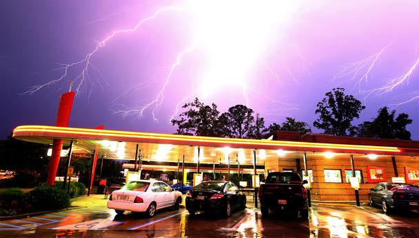
Image credit above: "
Lightning rolls through the sky over
Sonic restaurant in the Denbigh section of Newport News, Virginia,
Saturday, June 30, 2012, as severe thunderstorms moved through the area." (Rob Ostermaier/Newport News Daily Press/MCT)
$20,000 A Year For Flood Insurance? Sandy Survivors Face Tough Rebuilding Choices. U.S. News and
NBC News document the escalating costs of living on or near the ocean, in the wake of Sandy. Here's the intro: "
Thousands
of homeowners in New York and New Jersey impacted by Hurricane Sandy
are facing a tough choice that may thwart their efforts to rebuild:
Comply with costly new federal construction guidelines or prepare to
pay annual flood insurance rates that could top $20,000.New federal
flood maps revealed in June added 68,000 structures in New York City
and thousands more in New Jersey to flood zones. Now, affected
homeowners are being forced to make drastic changes to their residences,
such as elevating them on pilings, or incur punishing new insurance
premiums that will take effect by mid-2015. Given the new rules, many
Sandy survivors are grappling with whether they should alter their
properties – or leave..."
Photo credit above: John Makely / NBC News. "Kevin
Faller and Karen Spanover, of Toms River, N.J., learned that they
would have to invest tens of thousands of dollars to elevate their home
or else pay drastically higher flood insurance premiums."
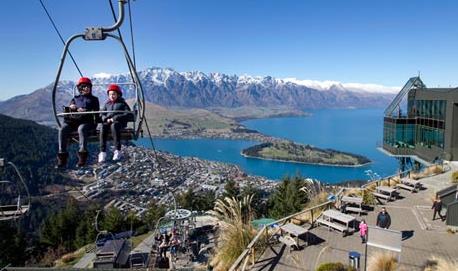
New Zealand Has Warmest Winter On Record.
The Guardian has the story - here's the intro: "
Winter lacked an Antarctic chill this year in New Zealand,
to record effect. Scientists said on Tuesday that the South Pacific
nation had its warmest winter since record-keeping began more than a
century ago. The average nationwide temperature was 9.5C (49.1F) for
June, July and August, about 1.2C above average and 0.3C above the
previous record set in 1984, the National Institute of Water and
Atmospheric Research said. Record-keeping began in 1909..."
Photo credit above: "
A bright sunny winter day at Queenstown, Lake Wakatipu and the Remarkables, in the South Island of New Zealand." Photograph: Mark Mitchell/AP.
Help Save Lily. I love dogs, and this urgent plea
caught my eye yesterday - sent to me by a friend. If you can make a
donation please consider helping this adorable puppy. Details via
gofundme.com: "
Lily
was only out of the hospital for 4 days and she is now back in again.
She was acting very tired and had no energy to bounce around and play
with her ball and wouldn't eat. She was very traumatized from her
first stay in the hospital and would not let her owner out of her sight
without whimpering. Now she has to endure more tests and x-rays and
they think her pneumonia was never fully cured. Of course there are now
several hundred dollars of more vet bills. We really want her to get
better for good but she is so small and weak. I feel really bad for my
sis who is over moon with this pup but was not prepared for these
enormous bills. Please help if you can..."
TODAY: Plenty of sun, still pleasant. DP: 60. Winds: NE 5-10. High: 83
WEDNESDAY NIGHT: Mostly clear and comfortably cool. Low: 56
THURSDAY: Sunny, less humid. Dew point: 51. High: 82
FRIDAY: Hazy sun, getting hotter. Dew point: 64. Wake-up: 64. High: near 90
SATURDAY: Sticky sun, T-storms up north. Wake-up: 70. High: 90
SUNDAY: Sunny start, PM clouds. Dew point: 62. Wake-up: 68. High: 83
MONDAY: Showers and T-storms. Wake-up: 64. High: 78
TUESDAY: Steamy sun. Storms north. DP: 67. Wake-up: 68. High: 89
Climate Stories....
Scientists: Climate Change May Offer Hurricane Help. Not sure about this one, but in the spirit of keeping an open mind, here's an excerpt from a story at
National Geographic: "
Many scientists have blamed global warming for more intense recent hurricane seasons and for the more destructive storms that are predicted in years to come,
but a new study says climate change could eventually help safeguard the
U.S. Atlantic Coast from hurricanes. Climate change might alter
atmospheric conditions so that future hurricanes may be pushed away
from the East Coast, according to a study published Monday by the
Proceedings of the National Academy of Science. The warming caused by
greenhouse gases—thought to be the result of human activities such as
burning fossil fuels—could redirect atmospheric winds that steer
hurricanes. By the next century, the study's authors report,
atmospheric winds over the Atlantic could blow more directly from west
to east during hurricane season, pushing storms away from the United
States..."
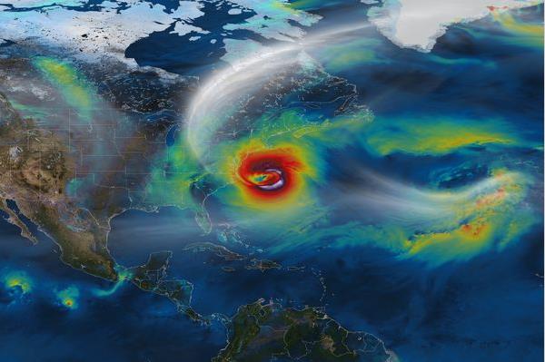
Image credit above: "
A NASA computer model of Hurricane
Sandy. A new study says climate change could make such storms less
likely along the Atlantic Coast." Photograph by NASA/ National Geographic Stock.
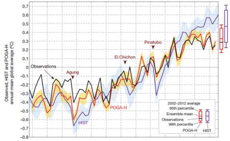
The Pacific Ocean Fills In Another Piece Of The Global Warming Puzzle. Here's a clip from a story at
The Guardian: "
A new study published in the journal Nature incorporates temperature changes in the tropical Pacific Ocean
into an advanced climate model, and finds that the model can reproduce
observed global surface temperature changes remarkably well.
Importantly, as authors Yu Kosaka and Shang-Ping Xie from the Scripps
Institution of Oceanography explain, accounting for the changes in the
Pacific Ocean allows the model to reproduce the slowed global surface
warming over the past 15 years. It also accurately reproduces the
regional and seasonal changes in surface temperatures, which adds
confidence that their results are meaningful..."
Graphic credit above: "
This
graph shows the good match between temperatures in the Nature paper
model (in red) and measured temperatures (in black). Just accounting for
human and solar climate influences doesn't reproduce the recent
surface warming slowdown (in purple)."
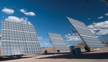
U.S. Study: Wind And Solar To Be Cost-Competetive By 2025. Business Green launches into the economics of renewables in this article; here's an excerpt: "Wind
and solar power generation will be cost competitive with fossil fuels
without recourse to federal subsidies by 2025, according to a new study
from the US National Renewable Energy Laboratory. The study, released last month and titled Beyond
Renewable Portfolio Standards: An Assessment of Regional Supply and
Demand Conditions Affecting the Future of Renewable Energy in the West,
argues that locating renewable energy assets in the most productive
regions of the country could serve to slash the cost of clean
electricity..."
U.N. Researchers: Global Warming Clock Is At "Five Minutes To Midnight". Here's an excerpt from an article at rawstory.com: "Humanity
has pushed the world’s climate system to the brink, leaving itself
only scant time to act, the head of the UN’s group of climate
scientists said on Monday. “We have five minutes before midnight,”
warned Rajendra Pachauri, whose organisation will this month release
the first volume of a new assessment of global warming and its impacts.
“We may utilise the gifts of nature just as we choose, but in our
books the debits are always equal to the credits,” Pachauri told a
conference marking the 20th anniversary of the environmental
organisation Green Cross International, quoting fellow Indian Mahatma
Gandhi. “May I submit that humanity has completely ignored, disregarded
and been totally indifferent to the debits?..."


No comments:
Post a Comment