By Paul Douglas
My favorite scenes from the movie "Gravity" included Sandra Bullock thumbing through instruction manuals for U.S., Russian and Chinese spacecraft. We can all feel her pain. That, and incredible images of the Earth - hurricanes, storms and city lights rotating into view far below. Truly breathtaking.
I was reminded of the fact that our atmosphere is roughly 12 miles thick, thinner than the skin on an apple.
Like a crazy old uncle who shows up, unexpectedly, at your front door - Old Man Winter is about to slink back into town. No accumulating snow (yet) but the atmosphere will be cold enough for flakes by next weekend. The first frost of the winter season is possible Thursday, likely by Saturday. Kiss your begonias goodbye.
This surge of chilly weather spins up a storm Monday; a period of heavier, steadier rain from this afternoon into much of Tuesday. Another long, cool drink for fields, lawns & gardens; helping to ease our drought a bit.
It's time to retire the shorts and drag a variety of jackets out of cold storage, but we'll see more hints of warmth. The GFS model is showing 50s, even a few 60s around Halloween. That said, it's time for a cold weather reality check.
________________________________________________________
MONDAY: Clouds thicken. Steadier rain develops late/overnight. High: 58.
MONDAY NIGHT: Steady rain likely. Low: 47
TUESDAY: Wet. Feels like November. High: 51
WEDNESDAY: Clouds giving way to sunny breaks. Wake-up: 39. High: 53.
THURSDAY: Another cold front. Patcy clouds. Wake-up: 34. High: 56.
FRIDAY: Mostly cloudy. Jacket-worthy. Wake-up: 37. High: 48.
SATURDAY: Frost risk. More clouds than sun. Wake-up: 31. High: 44.
SUNDAY: Sunny start, clouds increase by PM. Wake-up: 34. High: 48
_________________________________________________________
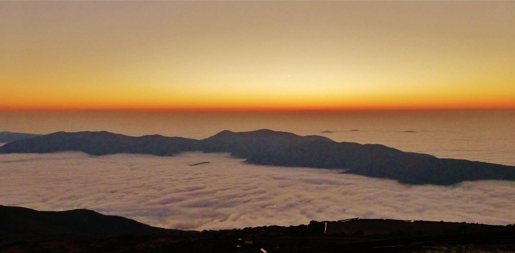
Sunday Sunrise
What a view atop Mount Washington Observatory on Sunday morning. The picture below was posted on
Mount Washington Observatory Facebook Page.
Sunrise Sunday morning over a sea of clouds as Weather Observer Rebecca Scholand took the first Day Shift observation.
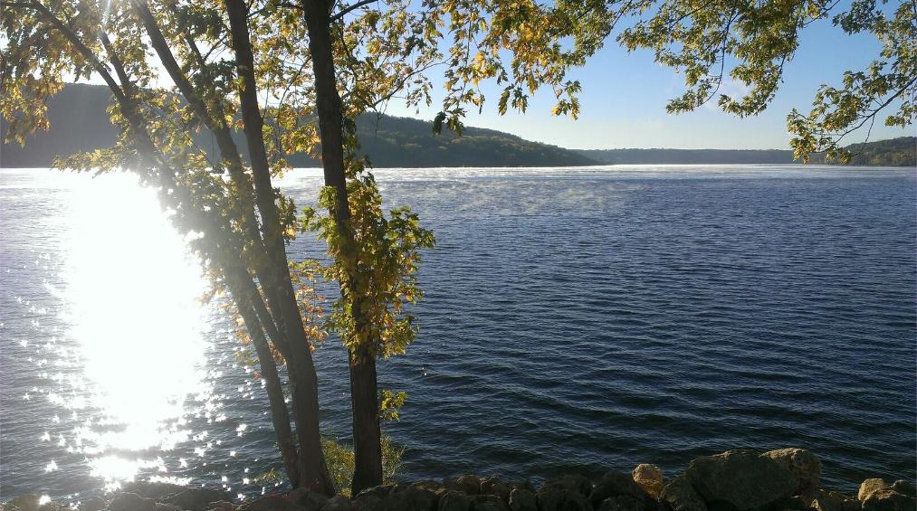
Here's another nice Sunday sunrise photo from my good friend, Matt Dux, out of Kansas City, MO.
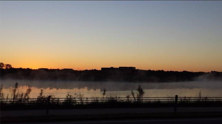
It was clear and chilly across the Upper Midwest as well. Here's another picture from Diana Opitz on Sunday morning from Minnesota. Note the steam rising off of the lake. Air temps colder than the water temp create the steam.
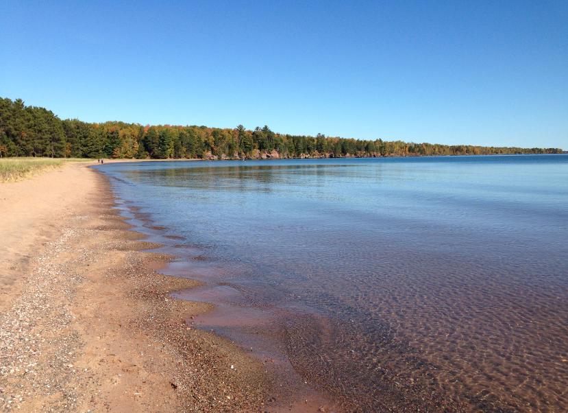
Madeline Island, WI
Thanks to Wade Weidner for for the picture below for the picture below from Madeline Island, WI. It was a beautiful day in northern Wisconsin too.
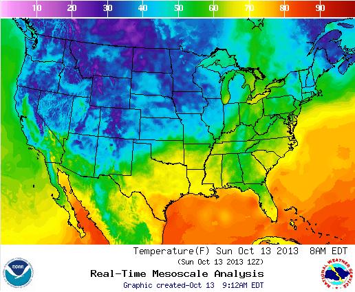
Autumn-Like Low Temps
Take a look at the low temperature map from AM Sunday. Widespread 30s and cooler were found across the northwestern half of the nation.
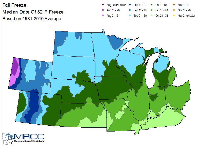
Average First Frost/Freeze Dates
According to the Midwestern Regional Climate Center, here are the average first frost/freeze dates across the Midwest. Interestingly, it seems as if we are a bit behind average for those first frost/freeze dates.
Average First 32 Temps
Average First 28 Temps

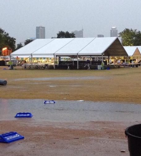
Heavy Texas Rainfall
Here's a Facebook post from WeatherNation on Sunday about the heavy rain in Austin, TX
"More than 10 inches of rain has fallen in parts of Austin, TX since yesterday, leading to flooding in spots. @ColinBurden shared this photo of flooding on the grounds of the Austin City Limits Music Festival, where today's festivities have been cancelled."
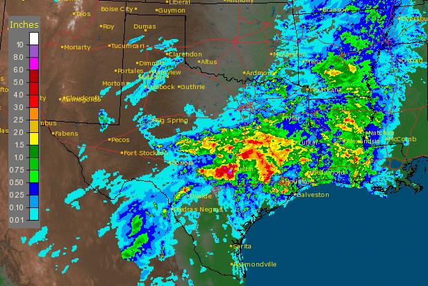
Significant TX Rainfall
According to the NWS radar rain estimates, nearly 10" of rain fell near the Austin, TX city limits.
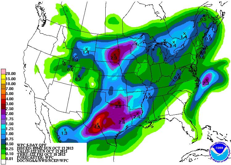
More Heavy Rain Potential
According NOAA's HPC 5 day precipitation forecast. There could be 1" to 3"+ rainfall for parts of the middle part of the country as this next storm system develops. Texas looks like it could be the golden rain gauge award winners from this next system. Good news as drought denting rains continue there.
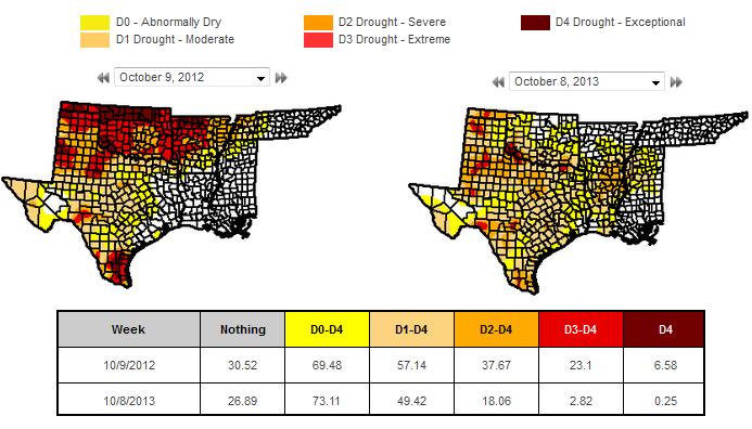
Drought Denting Rains
Despite the some of the flooding rains across parts of Texas lately, the rain is nice to see. The drought has improved quite a bit since last year. Take a look at the drought improvement below.
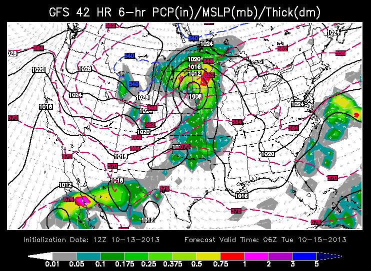
Storm Number 2
Another fairly large storm system will develop across the middle part of the country through the early part of the week. Here's a snapshot of the GFS (American model) solution for PM Monday/early AM Tuesday as the storm moves into the Midwest.
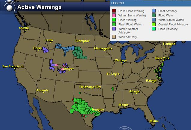
Flood & Snow Threat
This next storm system will be responsible for a flood and snow threat across parts of the nation. Here are the latest watches/warnings from the National Weather Service.
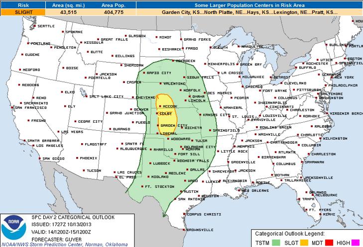
Severe Threat Monday
The Storm Prediction Center has issued a SLIGHT Risk of severe weather for Monday.
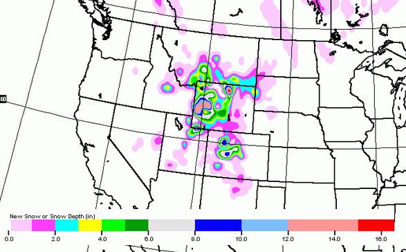
Cold Enough For Snow
Another blast of cooler air will slide in on the backside of this next storm. It'll be cold enough for snow across parts of the Rockies and High Plains. Here's a look at the snowfall potential over the next 5 days.
Cooler Weather Ahead
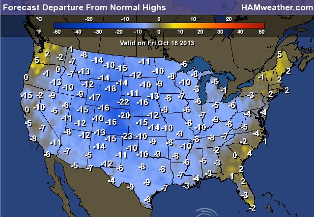
This next storm system will help to drag another blob of cooler air south of the border. The week ahead looks much cooler than what we had last week. Here's a look at how cool it could be across the nation this Friday.
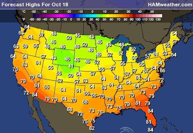
Friday's high temperatures across the nation look to be quite a bit cooler than normal for much of the nation. Some across the Front Range of the Rockies could be nearly 20F to 25F cooler than normal.
Thanks for checking in, have a great week ahead.
Don't forget to follow me on Twitter @TNelsonWNTV

No comments:
Post a Comment