Too Close For Comfort
Now THIS is scary! I remember fishing on a boat when I was a young kid when a storm surprised us, luckyly we made it to shelter safely. This is WAY too close for comfort!
"This might be the best reason we’ve ever seen to not fish during lightning. This is as close as you hopefully will ever see lightning on the water. This makes our skin crawl. How many of you have had close encounters from lightning, buzzing rods, floating line, or worse yet — struck? Watch this video. Crazy! Thanks to Tucker Owings for sharing on his facebook page."
See the video HERE:

Mount Washington Observatory
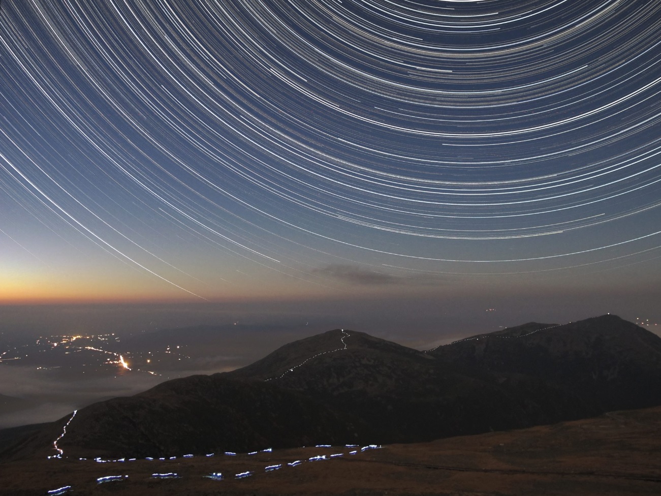
Too good not to share! This is an incredible picture from the Mount Washington Observatory - WOW!
"Star trails over Mt. Clay, Jefferson, and Adams (with Lancaster, NH in the valley to the NW). Image is made from over 1000 stacked images captured from 1900 EDT 10/12/13 through 0600 EDT 10/13/13. The white dots along the ridge are from a hiker going from north to south by headlamp."
See more HERE:
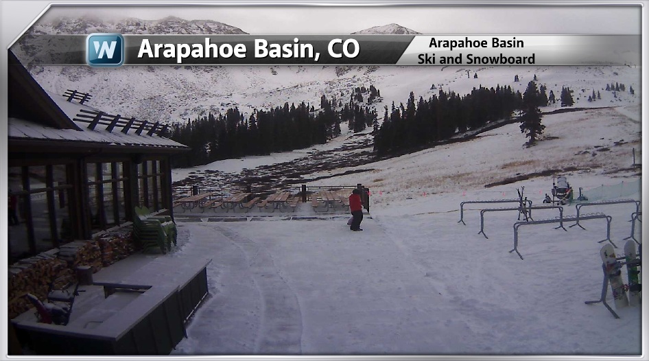
A-Basin Opens!!
WOW!! For all of you skiers and snowboarders out there, there's hope that the local resorts will be opening soon. Arapahoe Basin in Colorado opened this weekend, which was 4 days earlier than last year. The A-Basin webcam from earlier Monday, showed a little activity on the 2nd day of operation in 2013.
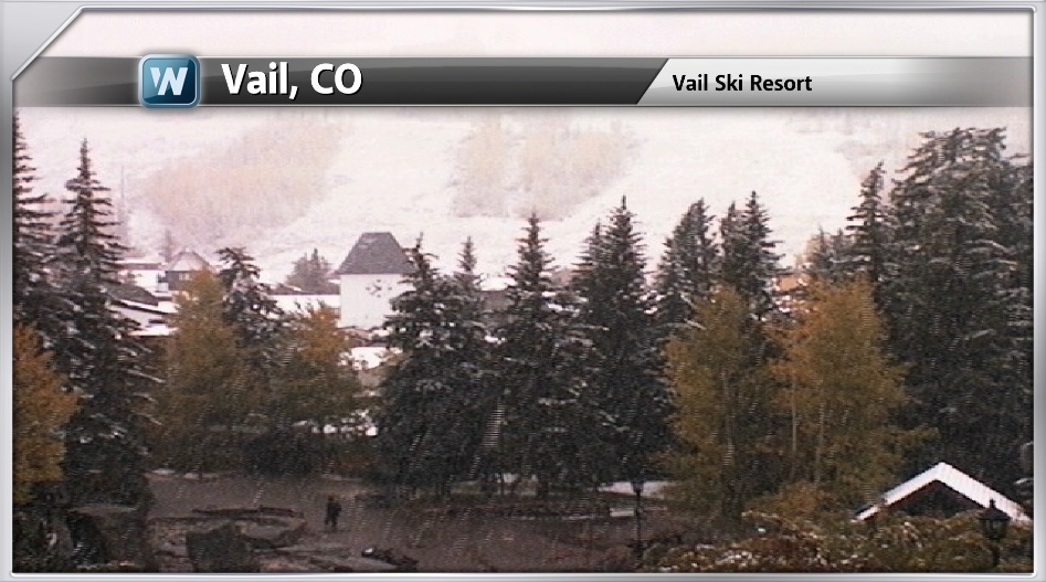
More Snowy Webcams
Here's another beautiful webcam from Vail, CO on Monday, which showed fresh snow falling at 8,150ft. in elevation.
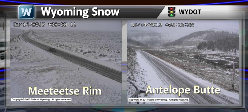
Snowy in Wyoming
Here are a couple of webcams from Wyoming that show a fairly snowy scenario too!
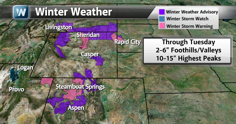
Winter Weather Headlines
The National Weather Service has issued a number of winter weather headlines through Tuesday. I believe this is the 4th consecutive week that we've had some type of winter weather headlines in the western part of the country. It seems as if we're turning a wintry corner, doesn't it?
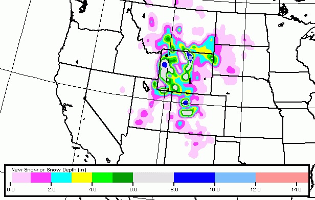
Snowfall Forecast
Here's the latest snowall forecast from the GFS (American model) which suggests a fairly decent amount across parts of the higher elevations, but note how some of this snow may be falling across the lower elevations in the High Plains.
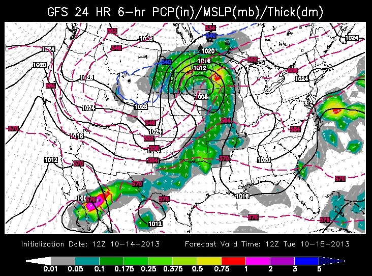
Storm #2
Weather maps sure have become more active in recent days/weeks. Here's our second storm system within a week's time now making it's way through the Upper Midwest. This fairly strong storm even looks more mature on the weather map below. Larger, more robust low pressure systems tend to look like commas.
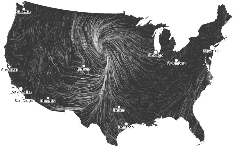
Find the Surface Low
The low pressure center by PM Monday was pretty easy to spot. Note the counterclockwise circulation over the Midwest.
See the latest wind map HERE:
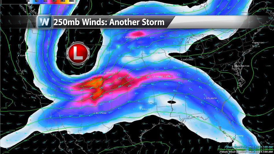
Upper Level Support
The image below shows the 250mb wind map from midday Monday, which shows a pretty stout area of low pressure in the west with a very strong upper level wind near the Four Corners Region. Strong winds located at the cruising altitude of a jetliner tends to help promote lift in the atmosphere.
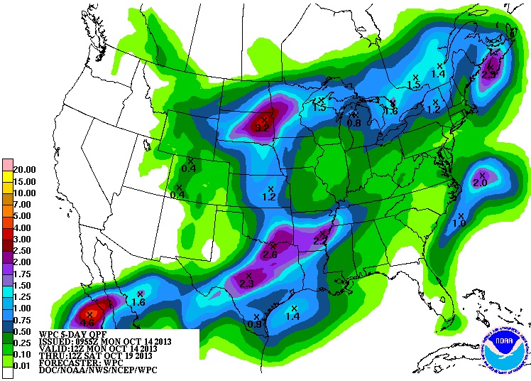
Expected Preciptation
According to NOAA's 5 day HPC precipitation forecast from AM Monday to AM Saturday, it appears the heaviest precipitation will be found in the central part of the country over the next couple of days. As the system slides east, it appears the moisture will begin to fizzle. Not as much precipitation is expected across the eastern part of the country later this week.
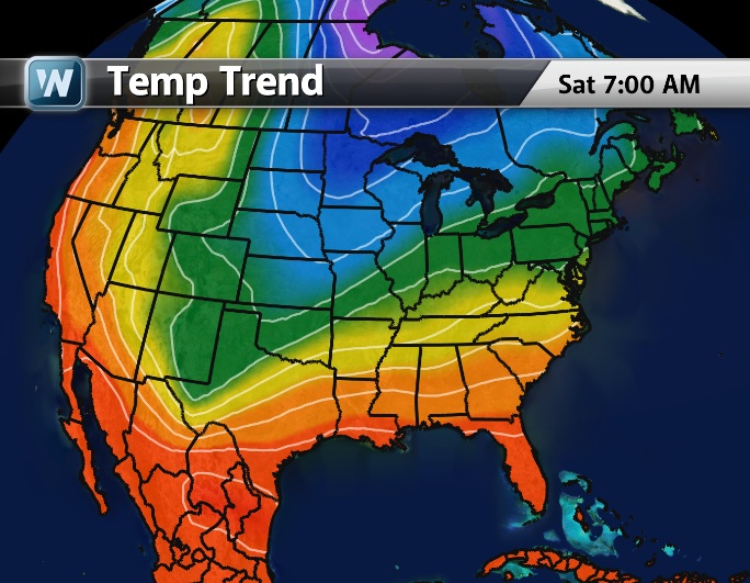
Colder Weather Ahead
Weather conditions this week will be quite a different this week, than what we had last week. A much colder air mass will be in place for the much of the nation. Another reinforcing shot of cold air will arrive later this week too and cool things down even more across the Upper Midwest/Great Lakes Region. I think we'll see our first widespread areas of frost by the weekend ahead across a large chunk of the Midwest/Great Lakes/Ohio valley by the weekend/early next week. The image below shows the jet stream buckling into the weekend with colder air from around the Hudson Bay moving into the Lower 48.
Temperature Trends
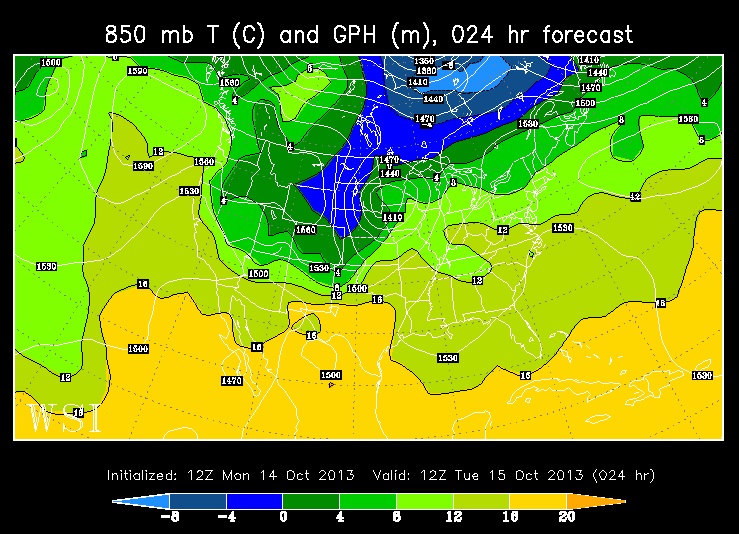
I don't seem much change in the active weather forecast for the eastern two-thirds of the nation through the end of the month. There appears to be several cold fronts/storm systems pushing across the nation over the next 2.5 weeks. The images below show the 850mb temperature trends... note the continued cooling through the week/weekend ahead.
850mb Temps AM Tuesday
Our current storm system is noted by the blue coloring (freezing temps and cooler) just a few thousand feet off the ground across the High Plains. This is the start of the cool down for much of the eastern two-thirds of the nation.
850mb Temps AM Saturday
Another cold front will push through the Upper Midwest later this week, with another reinforcing shot of cooler weather plunging into the Lower 48 into the weekend ahead. it'll be cold enough for flurries and areas of widespread frost across the far north this weekend... stay tuned for more!

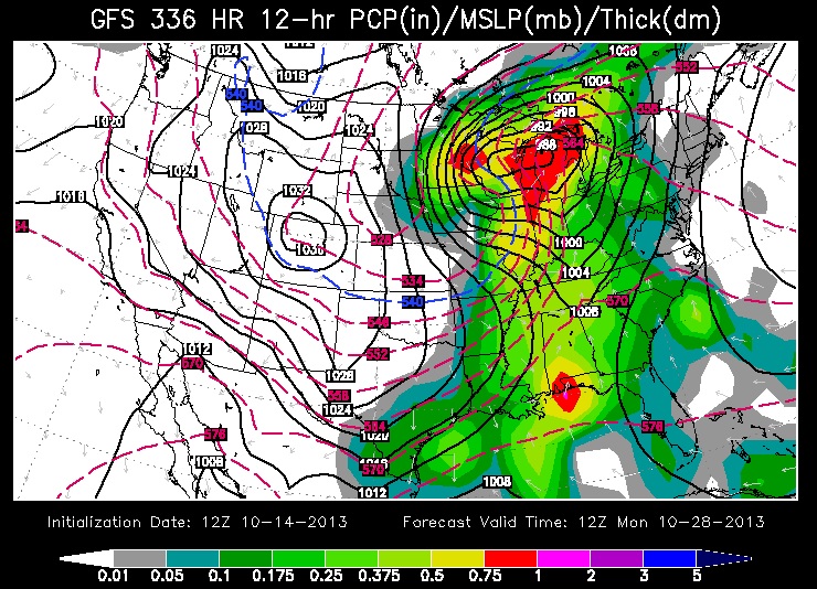
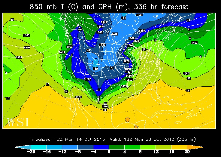
WISHCASTING
It's fun to see what the extended weather models cook up every now and then. Check out what the GFS (American model) develops by later this month. At this point, a storm of this magnitude is highly unlikely... More importantly, it appears that weather conditions will continue to stay active through the end of the month. Monitoring model trends, it'll be interesting to see if this wave even exists tomorrow; stay tuned!
Thanks for checking in, have a great week ahead!
Don't forget to follow me on Twitter @TNelsonWNTV

No comments:
Post a Comment