By Paul Douglas
My wife is right - I should have my head examined. Peering into an unknowable future and attempting to pinpoint weather at a given time & place is a daily lesson in humility.
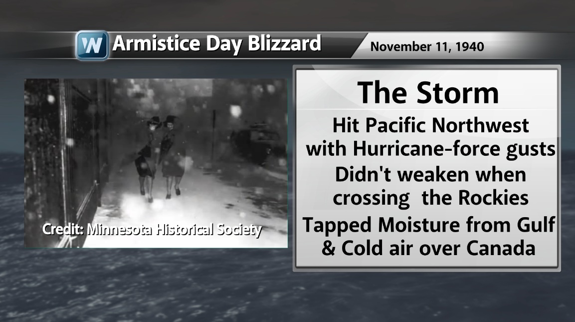
On this date in 1940 the Twin Cities were digging out from 16 inches of snow; 20 foot drifts out west. A paralyzing blizzard, one that wasn't predicted. 145 people died, 49 in Minnesota; mostly duck hunters stranded along the Mississippi. We went from 60s to blinding, horizontal snows in a matter of hours, catching everyone off guard.
In 1940 government forecasts were originating in Chicago. Since then local offices have opened up in the Twin Cities; we now have computer models, weather satellites and a constellation of Doppler radars. Could it happen again? The odds are less, but not zero. There will still be events where we shake our heads, where technology only goes so far.
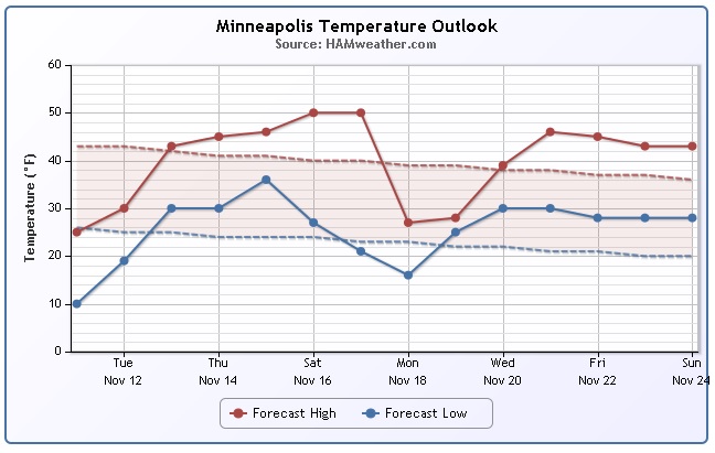
This is as cold as it gets this week, temperatures thawing to 50F over the weekend. Rain is likely late Saturday and Sunday AM.
Another surge of numbing, Canadian air sparks a colder storm next Monday. Accumulating snow is possible Monday night into Tuesday, followed by eye-watering windchill. Something to look forward to.
___________________________________________________________
TUESDAY: Cold, bright sun. Less wind. High: 31. Winds: NNW 5-10
TUESDAY NIGHT: Mostly clear, cold and quiet. Low: 22. Winds: W 5-10
WEDNESDAY: Plenty of sun, milder breeze. High: 43. Winds: W 5-10
THURSDAY: Clouds increase. Sprinkle/flurry possible? Wake-up: 33. High: 44
FRIDAY: Mix of clouds and sun. Chilly again. Wake-up: 32. High: 42
SATURDAY: Milder with increasing clouds. Rain at night. Wake-up: 33. High: 50
SUNDAY: Rain tapers early. Still mild. Wake-up: 44. High: 51.
MONDAY: Rain changes to snow. Wake-up: 42. High: 43.
_____________________________________________________
On This Day in Weather History: November 12
(Courtesy: NOAA)
2000: A winter storm system produced a narrow band of heavy snow across extreme western Minnesota. Winds toward the end of the event were clocked between 15 and 25 mph, throwing additional snow into the air resulting in reduced visibilities of 1 to 1.5 miles. Some snow totals included: Canby (Yellow Medicine County) with 6.5 inches, Madison (Lac Qui Parle County) with 6.0 inches.
1940: Record low highs were set in west central Minnesota. Alexandria had a high of 8 degrees Fahrenheit, Springfield and Willmar had highs of 10 degrees, and St. Cloud and Minneapolis had highs of 11 degrees.
1933: Duststorm hits Southwest Minnesota, while a blizzard rages in the Northwest.
Minneapolis Temperature Outlook
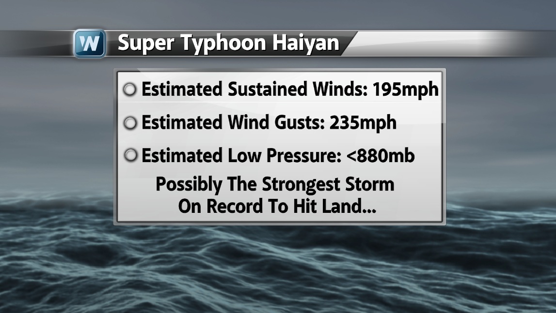
Super Typhoon Haiyan
It has been a few days since Super Typhoon Haiyan blew through the Philippines, but the damage is extensive. The concerns is that the death toll from Haiyan could top 10,000 over time.

Super Typhoon Haiyan Continued...
The estimated sustained winds associated with Haiyan were nearly 200mph with gusts up to 235mph. Satellite estimations are used in the West Pacific, while aircraft are used in the Atlantic basin and give a more accurate depiction of the storm. However, with that said, this could likely be the strongest hurricane/typhoon to ever make landfall.

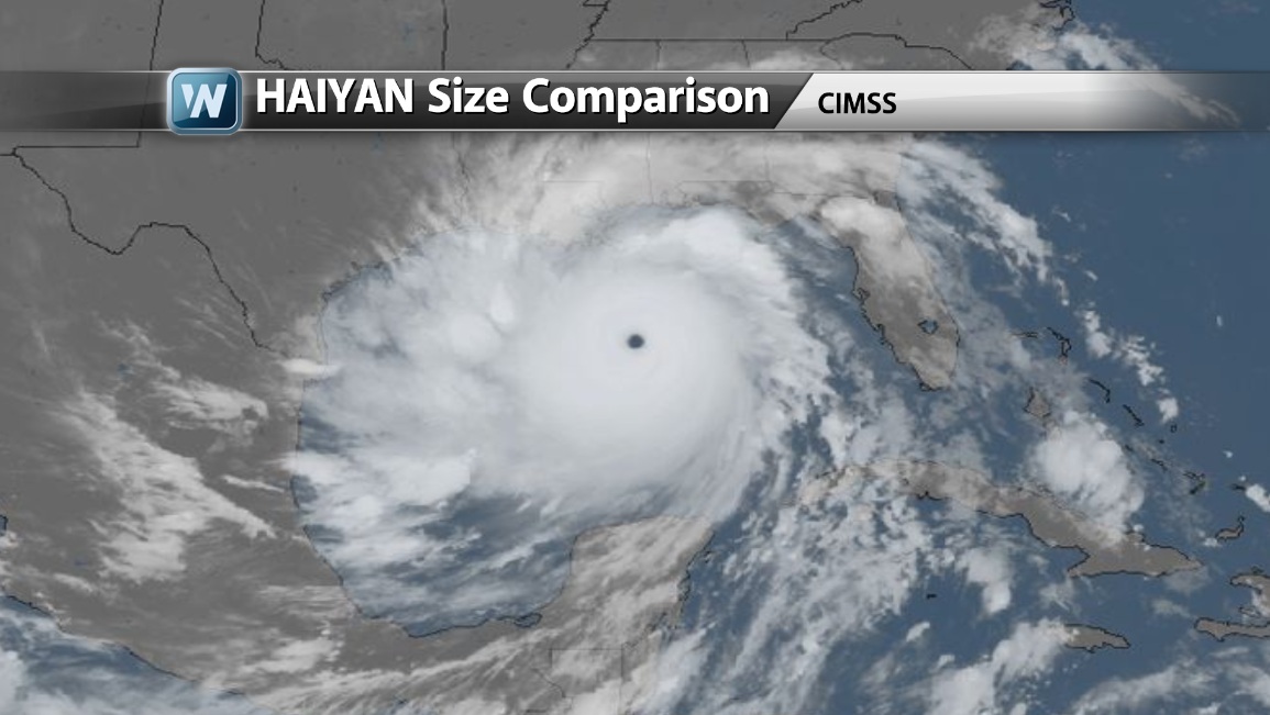
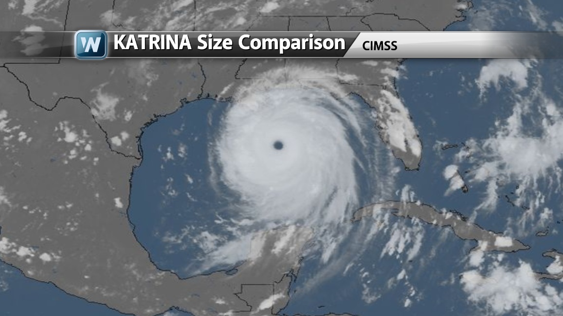
The Size of Haiyan
I thought this was interesting. The size of Haiyan compared to the Gulf of Mexico is shown below. Haiyan takes up nearly the entire area! Also note how big Katrina was in 2005 and how much bigger Haiyan really was!
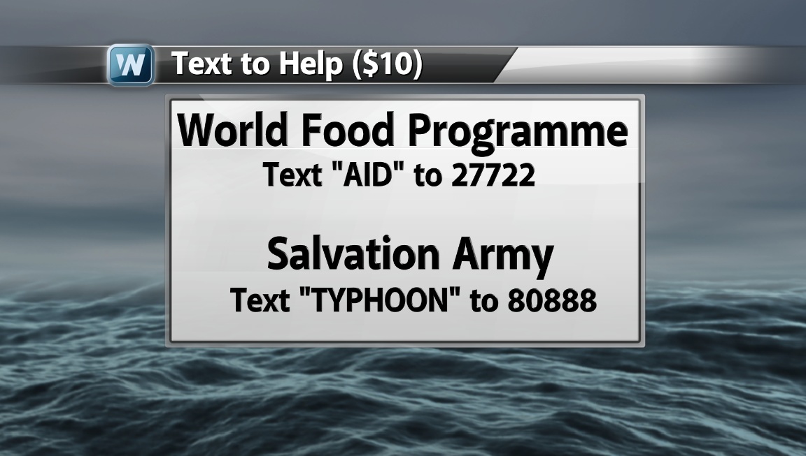
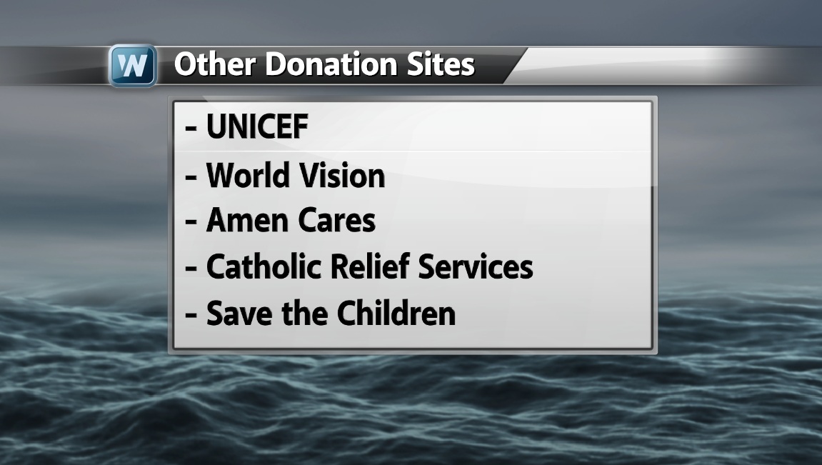
HELP!
There are a number of different ways you can help. A number of different organizations are excepting donations/etc.
Here's how you can help:
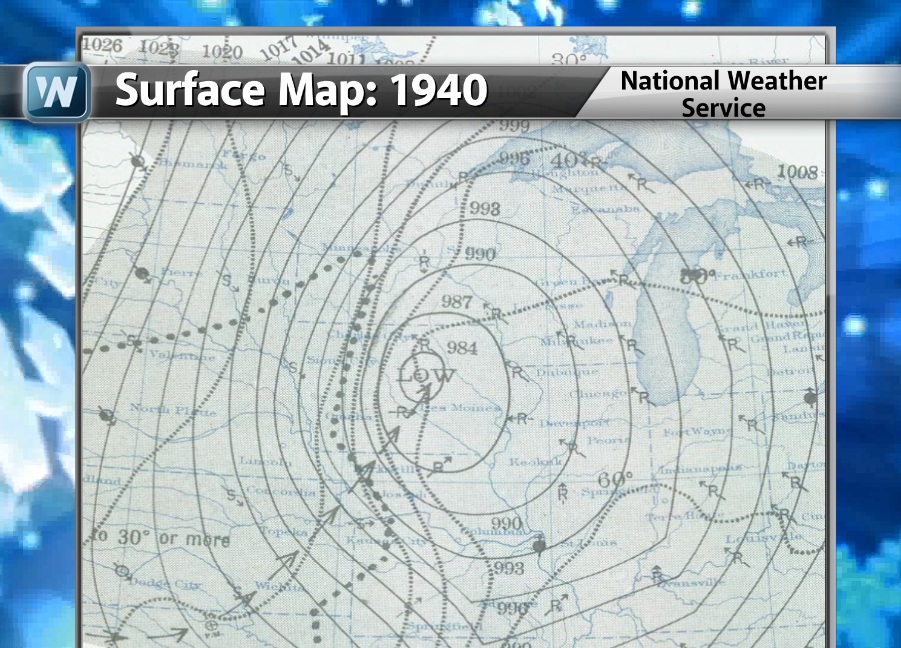
Armistice Day Blizzard of 1940
November is typically known as an active month weather-wise as big storm systems wrap up across the midsection of the nation. With increasingly longer nights and a growing snow pack, the cold air mass is building across the far north. This increase in temperature gradient from north to south tends to whip up "Gales of November" storms. Once such system developed on Armistice Day back in 1940!
Read more HERE:
Read more HERE Too:
Cold and Snowy
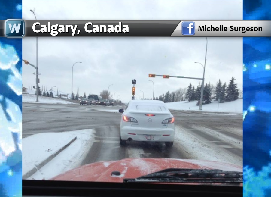
Our current Arctic front is nothing like the Armistice Day Blizzard of 1940, but it's getting a few peoples attention. We've seen snow from Calgary, Canada to the Midwest and Great Lakes Region. Here was a picture from a good friend of mine, Michelle Surgeson out of Calgary, Canada.
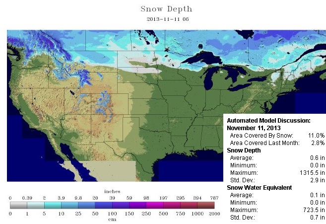
U.S. Snow Pack
According to NOAA's NOHRSC, 11% of the nation was covered in snow, but only those along the extreme northern fringe of the nation and those in the mountains in the west. Note how much of the southern tier of Canada appears to be snow covered, this is certainly helping to keep the air chilled up there.
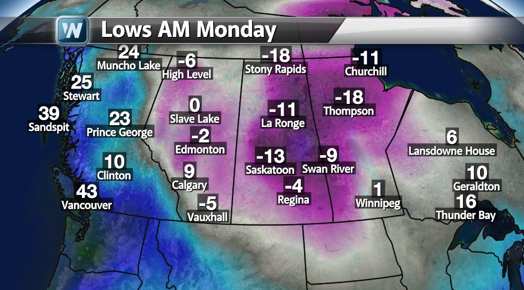
Cold Temps
Here were the actual low temps reported AM Monday across the prairie provinces of Canada. Note the near -20° low temps reported as this Arctic air mass oozed south into the lower 48.
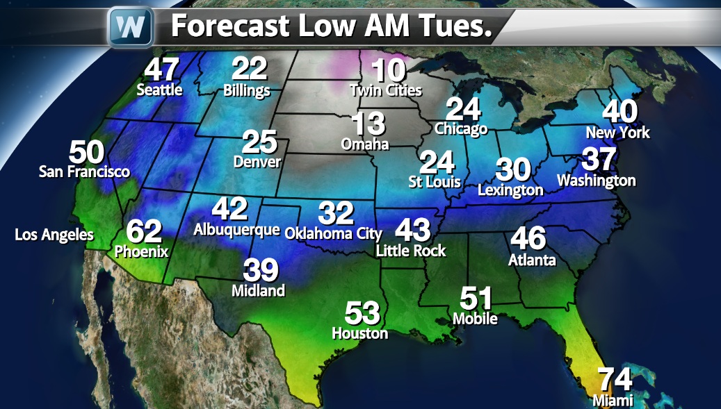
One thing to keep in mind is that there is very little snow on the ground across the Lower 48, so as the cold air sinks south, the air mass will moderate. Sure it'll be cold, but not as cold as what we've seen in Canada due to the lack of snow! Thanks goodness!! In the graphics below, note how the integrity of the cold begins to weaken over time. Again, it'll be some of the coldest air of the season for folks east of the Rockies, but it won't be as cold as what we had in Canada.
Forecast Lows AM Tuesday
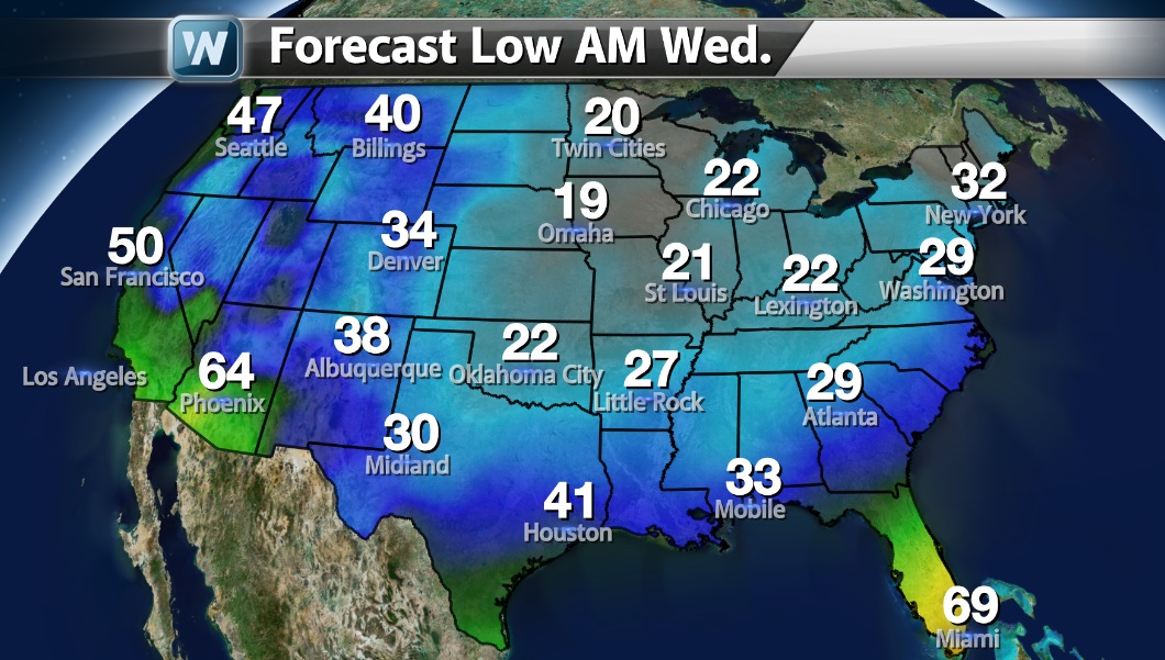
Forecast Lows AM Wednesday
Great Lakes Snow
The lake effect snow machines are kicking into gear again. Because of our current cold air mass, lake effect snows will continue through Tuesday and add up to 6"+ in a few spots downwind of the Great Lakes.
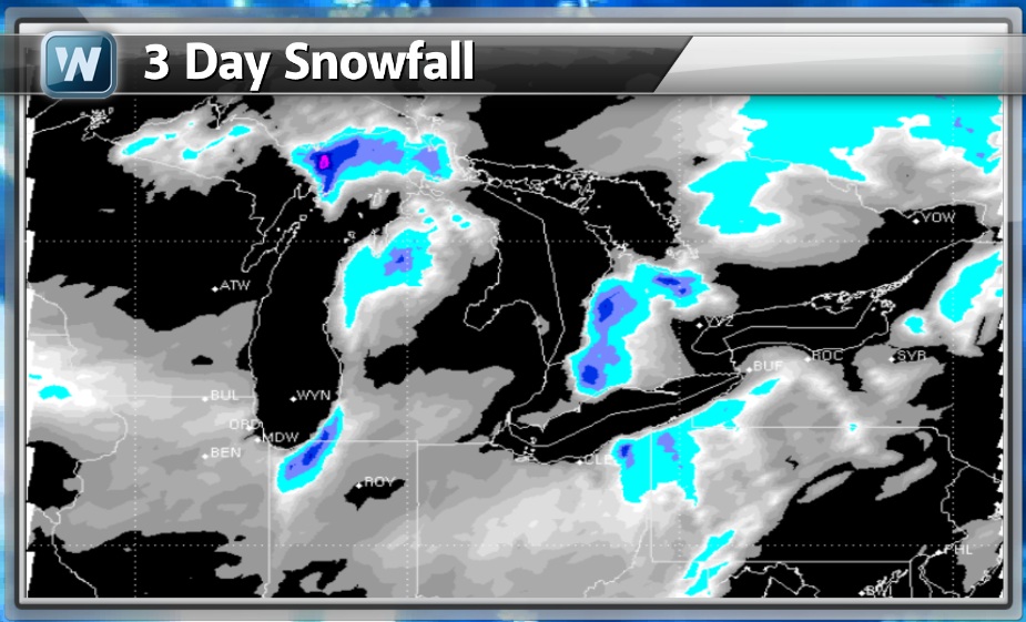
Snow Potential
The Arctic front will still squeeze out some snow in spots across the Ohio Valley and Appalachians through Tuesday. Other than that, it doesn't appear that there will be any SIGNIFICANT snowfalls across the nation within the next few days.
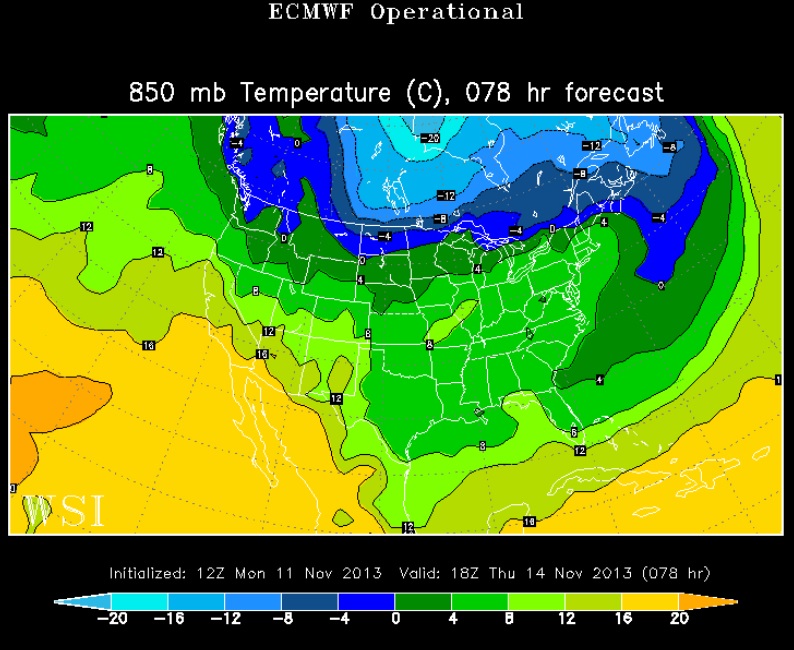
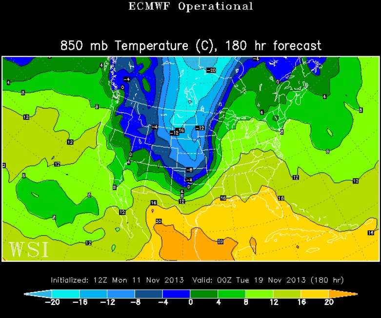
Looking Ahead/More Cold
Here's a look at the temperature trend from week to week. Our current Arctic air mass looks to plunge as far south as the Gulf Coast States by Tuesday with frost and freeze likely. However, we do get a little wedge of warmth to replace this chill by the end of the week. Looking ahead, weather models are hinting at another cold front by early next week... Keep those jackets handy, it is November after all
Temps Tuesday
Temps Thursday
Temps Next Monday, November 18th
Thanks for checking in, have a great week ahead!
Don't forget to follow me on Twitter @TNelsonWNTV

No comments:
Post a Comment