46 F. high in the Twin Cities Sunday.
40 F. average high on November 17.
54 F. high on November 17, 2012.
November 17 in Minnesota Weather History (Twin Cities National Weather Service):
1994:
58 to 69 mph wind gusts resulted in isolated damage to structures
across south central and southeastern Minnesota. Some of the counties
included were Blue Earth, Faribault, Freeborn, Goodhue, Le Sueur,
Nicollet, Rice, Steele, and Waseca.
1979: Heat wave continues in Southwest Minnesota. Temperature hits 70 degrees at Browns Valley.

"...
Measurable
snow fell on 27 of the past Thanksgivings back to 1884, about every
five years or so. The most snow that fell on Thanksgiving was five
inches in 1970. The last time there was measurable snow on Thanksgiving
was just last year with .1 (one tenth of an inch) of snow..." - from a Minnesota Climatology Working Group post on Thanksgiving Day weather from 1872-2012. Details below.
"...
But
herein lies the crux—we no longer live in a world without warming.
Given that 1985 was the last year with temperatures below the
20th century average, and 2000-2010 was the hottest decade on record, it
has become impossible to say for certain that any given storm is free
from the influence of our warmed world..." - excerpt from a post at EcoWatch.com; details below.
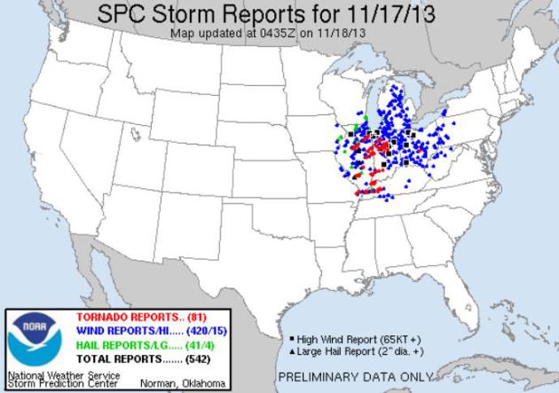
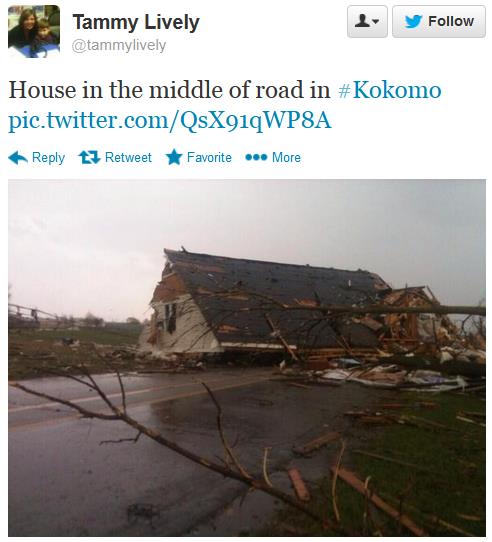
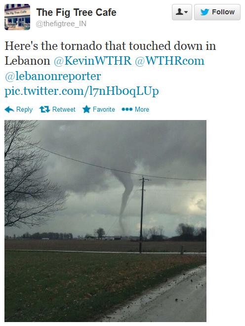
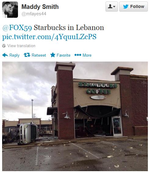
Head-shaking Outbreak
In
Meteorology 1 you learn the atmosphere is most unstable in spring;
that's when destructive tornadoes are most likely to touch down on the
USA. Yesterday's outbreak was historic; the maps looking like May, not
November. Around 80 tornadoes, some large and violent, on the 17th day
of November? Surreal.
Weather patterns are shifting north as we
continue to warm; more moisture & energy in the system. Yesterday
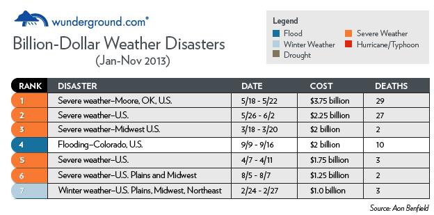
may have been the 8th billion-dollar weather disaster of 2013. According
to Aon Benfield 5 of the 7 U.S. billion-dollar disasters in 2013 were
related to severe storms & tornadoes; the 3rd highest on record.
Only 2011 & 2012 saw more severe storm damage.
A trend? We'll see.
Jeff
Masters reports yesterday's "High Risk" was the farthest north an
extreme tornado outlook was issued by SPC so late in the season.
Winds
ease today; temperatures nudging 50F again Tuesday. A little rain
streaks into town Wednesday - a colder front capable of sparking some
light snow Thursday night. Nothing "plowable" though.
The next
swipe of arctic air arrives Friday; highs hold in the 20s Saturday
before recovering next week. GFS data shows 30s to near 40F around
Thanksgiving with no big storms.
Feeling lucky?
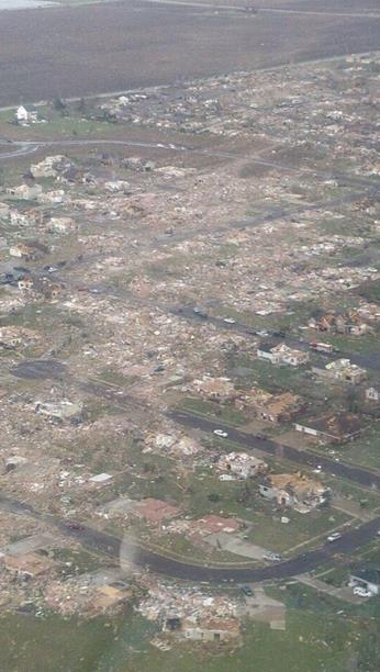
Path Of Destruction.
Here is why NOAA SPC issued a "High" Risk yesterday, evidence of large,
long-lasting, long-track tornadoes in Washington, Illinois, on the 17th
day of November. Details from Severe Studios: "Confirmed aerial photo
of tornado damage in Washington, IL (originally tweeted by ) .
An Awe-Inspiring Day.
The death toll and injury count could have much higher yesterday. NOAA
did a good job getting the word out; a "High Risk" coupled with multiple
PDS (Particularly Dangerous Situation) Tornado Watches issued by late
morning, reflecting the gravity of the situation. You don't expect EF-2
and EF-3 tornadoes on the 17th day of November, but the dynamics aloft
were strong enough yesterday. More detail on where the 81 tornadoes (as
of 11 PM) touched down via
NOAA SPC.
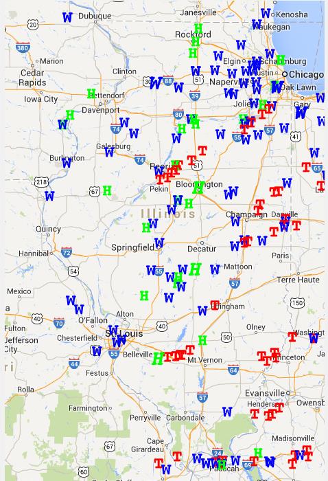
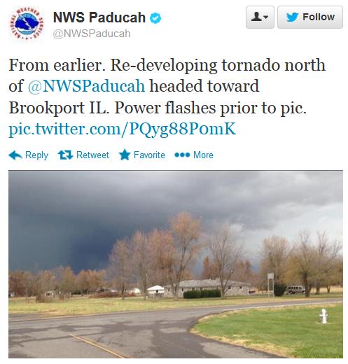
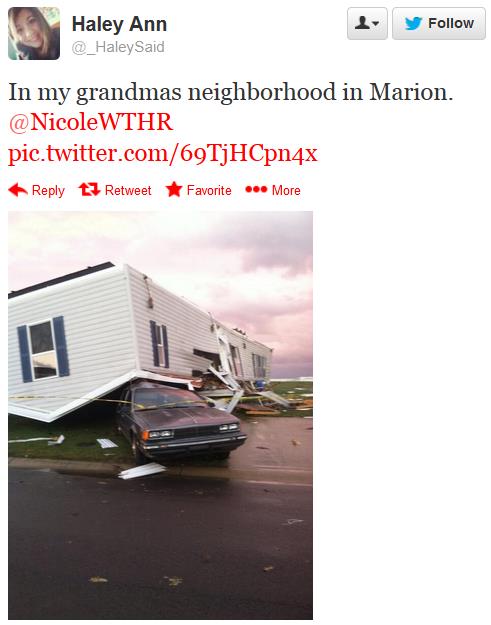
Illinois Supercell Tracks.
Here is more detail on the tornadoes and straight-line winds that swept
across Illinois on Sunday, an historic late-season outbreak unlike
anything I can ever remember: Details from the
Illinois Climate Office: "The Midwest was hit with a major tornado outbreak on Sunday, November 17, 2013. The preliminary reports can be found on the
NOAA Storm Prediction Center reports page.
Below is a map showing the preliminary reports. Click on the map to go
to the Storm Prediction Center Google map server to zoom in and out,
etc. Additional NWS reports can be found from the
Chicago office and
Lincoln office.
At this time, the communities hardest hit in Illinois were Pekin, Washington, and Gifford."
Midweek Thaw - Weekend Chill.
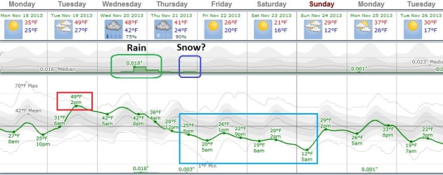
ECMWF data courtesy of Weatherspark shows highs near 50F by early
afternoon Tuesday, a period of rain showers Wednesday - possibly a few
hours of light snow Thursday night as much colder air arrives. The
"Euro" has been overestimating the extent of Canadian chill in recent
weeks; not sure we'll see highs in the 20s by Friday and Saturday, but
there's little doubt we'll down well below average by the weekend.
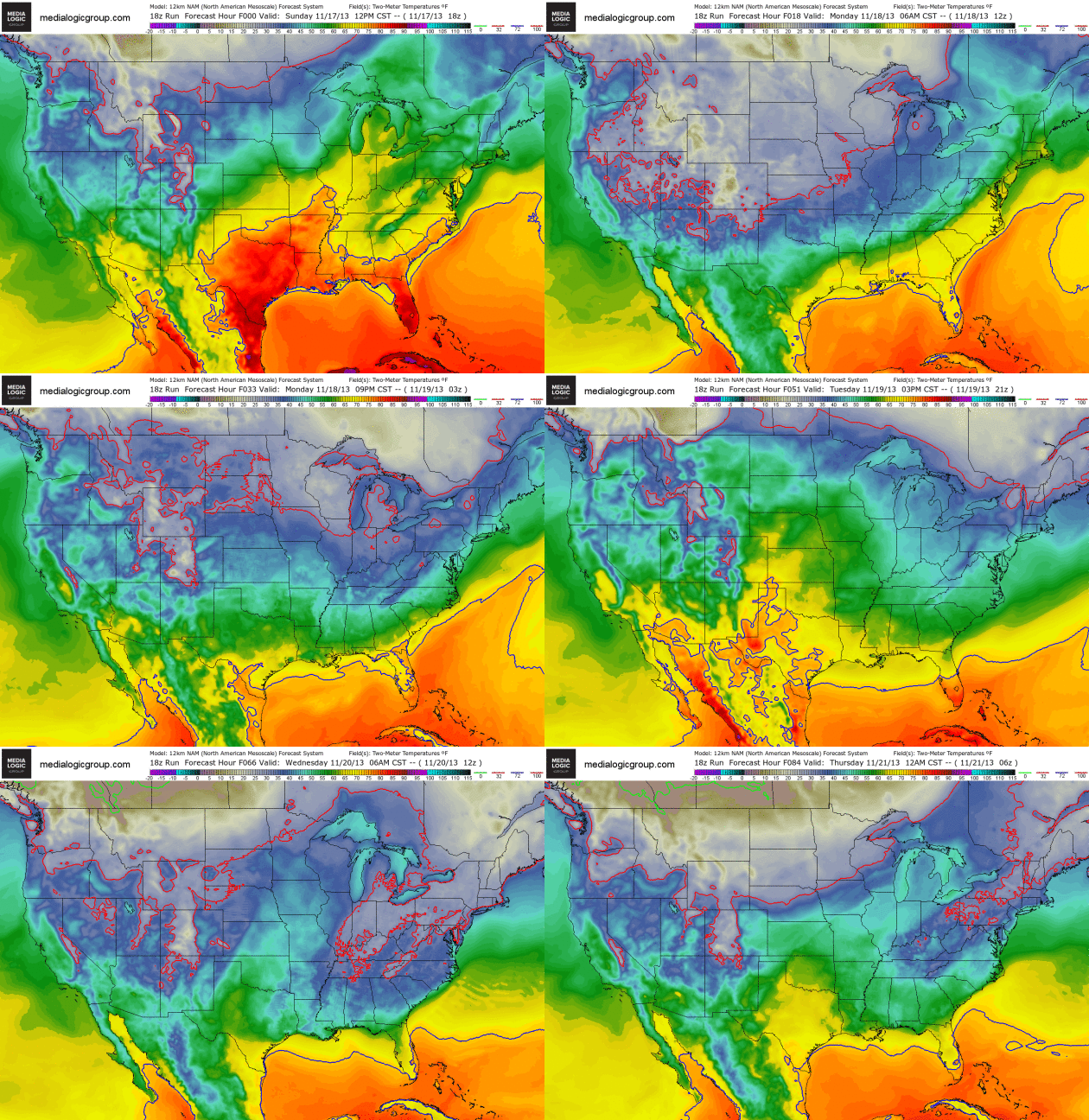 84 Hour Temperature Trends.
NOAA's NAM model of 2 meter temperatures shows plenty of chilly air
over the northern USA, a brief warming trend over the central USA
Tuesday and Wednesday before much colder air approaches - the subzero
isotherm showing up just north of the USA/Canada border by Thursday
morning. Loop: Ham Weather.
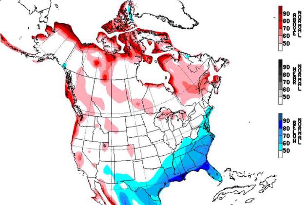
Temperature Biases Next Week. The map above shows predicted temperature anomalies from November 23-27, courtesy of NOAA and the NAEFS model.
8-14 Day Temperature Trends.
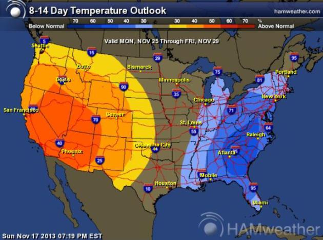
NOAA CPC also shows a cold bias for much of the eastern USA
Thanksgiving Week, a warm bias west of the Rockies as high pressure
builds. The central USA will see rapid temperature swings in the coming
weeks. Map:
Ham Weather.
Prevailing Winds Next week.
A persistent trough of low pressure forming over eastern Canada and the
eastern USA will mean a cold bias east of the Mississippi River,
temperatures staying milder than average for much of the west. The NOAA
map above shows average 500 mb (18,000 foot) winds between November
23-27.
Thanksgiving Day Climatology.
60F or knee-deep in snow? Somewhere in-between this year, in all
probability. Here are a couple of clips from a comprehensive look back
at Thanksgiving Weather for MSP since 1872, courtesy of the
Minnesota Climatology Working Group: "
Because
Thanksgiving Day occurs at the transition period between autumn and
winter, Thanksgiving weather can be balmy to brutal. A typical
Thanksgiving Day in the Twin Cities has high temperatures in the 30's
and at least a bit of filtered sunshine. Having a mild day in the 50's
on Thanksgiving Day is relatively rare, looking at the historical record
back to 1872. A maximum of 50 or more has happened only eleven times in
141 years, or about once every 14 years or so. The warmest Thanksgiving
Day is a tie of 62 degrees set in 1914 and 1922. The mildest recent
Thanksgiving Day is 60 degrees just last year on November 22, 2012. This
tied 1939 as the third warmest Thanksgiving back to 1872 for the Twin
Cities...Last Thanksgiving was even rarer than most, producing a balmy
60 degree high during the day and a chilly accumulation of 0.1 inches of
snow that night. Thanksgiving weather like this has not been seen in
141 years..."
December: A Wintry Correction?
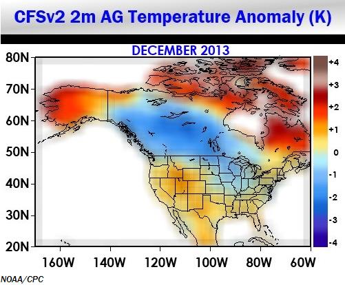
Larry Cosgrove at WeatherAMERICA shared this graphic, showing NOAA's
CFS (Climate Forecast System) outlook for December: colder for the Upper
Midwest and Great Lakes, but trending milder for much of the east,
south and western USA.
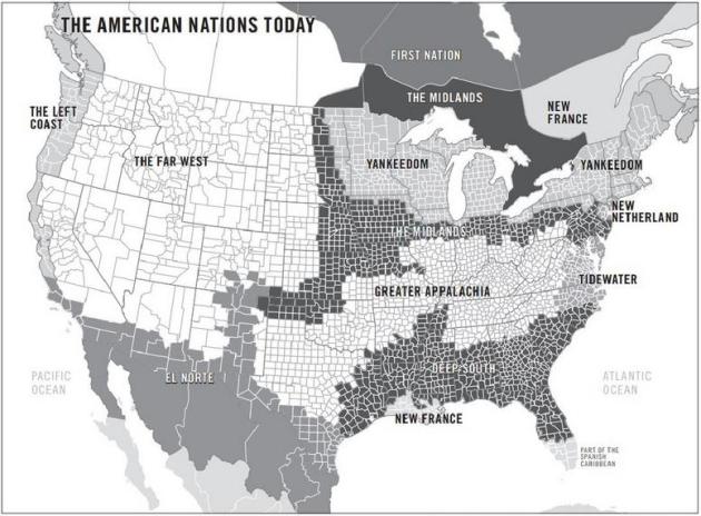
Forget The 50 States; The U.S. Is Really 11 Nations, Author Says. I found this fascinating and vaguely horrifying - here's an excerpt from
NPR: "
For
hundreds of years, this nation has been known as the United States of
America. But according to author and journalist Colin Woodard, the
country is neither united, nor made up of 50 states. Woodward has
studied American voting patterns, demographics and public opinion polls
going back to the days of the first settlers, and says that his research
shows America is really made up of 11 different nations. "Yankeedom" in
the Northeast and industrial Midwest was founded by Puritans and
residents there have always been comfortable with a government that
regulates and moderates..."
Map above: Colin Woodard's map of the "11 nations."
If This Doesn't Terrify You: Google's Computers OUTWIT Their Humans.
In 20 years will we all be working for computers? Who knows - but
here's another unsettling glimpse into the future; an excerpt from a
story at
The Register: "
Google
no longer understands how its "deep learning" decision-making computer
systems have made themselves so good at recognizing things in photos.
This means the internet giant may need fewer experts in future as it can
instead rely on its semi-autonomous, semi-smart machines to solve
problems all on their own. The claims were made at the Machine Learning
Conference in San Francisco on Friday by Google software engineer Quoc
V. Le in a talk in which he outlined some of the ways the
content-slurper is putting "deep learning" systems to work. (You find
out more about machine learning, a computer science research topic, here [PDF].)..."
The
claims were made at the Machine Learning Conference in San Francisco on
Friday by Google software engineer Quoc V. Le in a talk in which he
outlined some of the ways the content-slurper is putting "deep learning"
systems to work. (You find out more about machine learning, a computer
science research topic,
here [PDF].)TODAY: Bright sun, less wind. Winds: NW 10. High: 36
MONDAY: Bright sun, less wind. Winds: NW 10+ High: 36
MONDAY NIGHT: Clear and chilly. Low: 27
TUESDAY: Partly sunny, turning milder. High: near 50
WEDNESDAY: Growing chance of rain showers. Wake-up: 42. High: 49
THURSDAY: Cold wind, light snow at night? Wake-up: 36. High: 37 (falling)
FRIDAY: Partly sunny, "cold enough". Wake-up: 21. High: 29 (single digit wind chills)
SATURDAY: Blue sky, dig out the coats. Wake-up: 17. High: 26
SUNDAY: Dim sun, not as cold. Wake-up: 16. High: 35
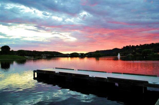
* photo above: Renee Schneider.
Climate Stories...
Study Shows Most Think Global Warming Is Real. The Daily News Journal has the story - here's the introduction: "
The
vast majority of Americans in each of 40-plus states surveyed say
global warming is real, serious and man-made, and the concerns tend to
be slightly higher in coastal or drought-stricken areas, says an
analysis out this week.At least 75 percent of U.S. adults say global
warming has been happening, but the Stanford University research found
that 84 percent or more took that view in states recently hit by drought
— Arizona, New Mexico, Oklahoma and Texas — or vulnerable to sea-level
rise: Delaware, Maine, Massachusetts, New Jersey, New York and Rhode
Island..."
Super Typhoon Haiyan: Realities Of A Warmed World And Need For Immediate Climate Action. Dr. Michael Mann has the Op-Ed at
EcoWatch; here's an excerpt: "...
For now, super storms are still rare. However, models suggest more frequent and intense storms in a warmed world.
A number of scientists suspect that certain recent storms like Sandy
and Haiyan exhibited characteristics outside the range of natural
variation. Although exact measurements are hard to come by (there were
no flights in the Western Pacific to provide direct measurements)
satellite images along with readings of ocean heat
seem to suggest that Haiyan was an unnaturally powerful storm. The
science is hinting that this storm may not have been so catastrophic in a
world without warming. The unusually deep, unusually warm pool of water
that provided the initial fuel is unlikely to have existed in a world
without warming..."
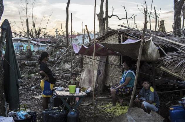
Photo credit above: "
A family
outside their makeshift home in Guiuan, Philippines, Nov. 17, 2013.
Typhoon Haiyan barreled through the Philippines over a week ago, killing
thousands." (Bryan Denton/The New York Times).
Typhoon Reminds Us Climate Change Is About People. Here's an excerpt of a post at
SFGate: "...
Presenters,
including me, often share findings from scientific research, show
intricate charts and offer better ways forward while pointing to the
risks of doing nothing - rising sea levels, deforestation, land
degradation. What is often missing - and what has become so painfully
clear in these past few days since Typhoon Haiyan tore through the
central Philippines - is that what we're really talking about is people.
Climate change is about people. It's about livelihoods that are
affected and sometimes destroyed when severe weather ravages the land
they depend on for income. It's about displacement when they are then
forced to leave home in search of a better life in communities that do
not have the capacity to absorb them. And it's about survival in areas
that do not have the infrastructure in place to withstand
extreme weather..."
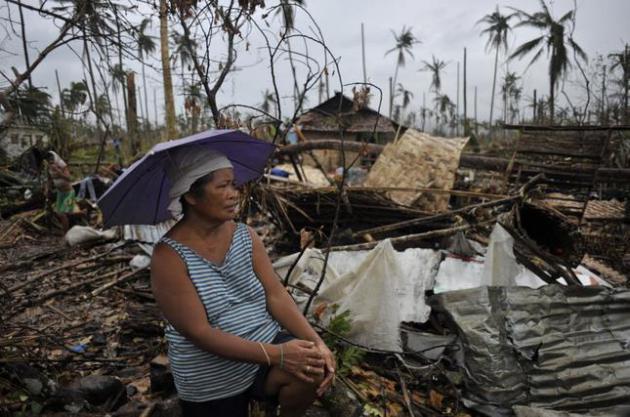
Photo credit above: "
Editha
Ladera, a farmer, surveys the damage to her property in Jaro, Leyte
province, Philippines, Nov. 17, 2013. Typhoon Haiyan barreled through
the Philippines over a week ago killing thousands." (Jes Aznar/The New York Times).
 "...Measurable
snow fell on 27 of the past Thanksgivings back to 1884, about every
five years or so. The most snow that fell on Thanksgiving was five
inches in 1970. The last time there was measurable snow on Thanksgiving
was just last year with .1 (one tenth of an inch) of snow..." - from a Minnesota Climatology Working Group post on Thanksgiving Day weather from 1872-2012. Details below.





No comments:
Post a Comment