By Paul Douglas
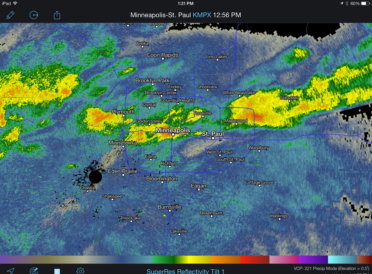
The Symphony of Seasons is playing out of tune again. The latest atmospheric disconnect came yesterday: reports of T-storms, even small hail over the southeastern suburbs. Odd for mid-November, but not unprecedented. NOAA data from 1971-2000 shows an average of .6 "thunderstorm-days" at MSP in November, if anyone asks. Which is doubtful.
Another head-shaking moment in the weather center: after one of the quietest tornado seasons in 40 years Mother Nature decides to act up, on November 17. A squall line capable of damaging straight-line winds and tornadoes will plow across the Ohio Valley by afternoon.
Showers brush Minnesota, but the heaviest rain passes well south & east of town today. And by the time it's cold enough for snow moisture will be well to our east tonight.
The models are more unreliable than usual, even the ECMWF. It keeps printing out eye-popping cold waves, but as the event approaches the cold air fades with time.
We cool off Monday, but not nearly as cold as we were expecting a few days ago. Highs brush 50F Tuesday & Wednesday, cooling off late week with a chance of light snow Friday.
The GFS is hinting at 30s & 40s for Thanksgiving Weekend. Stay tuned.
________________________________________________________________________
SUNDAY: Peeks of sun with a slight chance of light rain. Heavier/steadier rain (and thunder) stays east from southeastern Minnesota into central and eastern Wisconsin. Turning windy and cooler. High: 48. Winds: SSW turning WNW 15-25.
SUNDAY NIGHT: Stray sprinkle or flurry. Still breezy, turning colder. Low: 27. Winds: WNW 10-20
MONDAY: Chilly sun, winds dying down. High: 36. Winds: W 10-15
TUESDAY: Bright sun, not as chilly. Winds increasing in the afternoon. Wake-up: 25. High: 43. SSE 10-20
WEDNESDAY: Another cold front. A brief rain shower possible. Wake-up: 33. High: 45. Winds: Turning N 10-20 later
THURSDAY: Lingering clouds. A stray flurry possible. Wake-up: 28. High: 37
FRIDAY: Mostly cloudy. Chance of snow. Wake-up: 25. High: 36
SATURDAY: Feels like late November. Wake-up: 24. High: 36
___________________________________________________________________
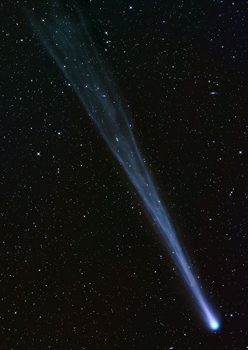
Comet ISON
Did you hear about the comet visible to the naked eye? It's comet ISON, which will make a close encounter with the sun on Thanksgiving Day!
"The tail is so long, he couldn't fit the whole thing in the field of view. How long is it? Comet ISON's tail extends more than 8 million kilometers behind the comet's nucleus. For comparison, that's 21 times the distance between Earth and the Moon."
Read more from Spaceweather.com HERE:
(Image courtesy: Waldemar Skorupa from Kahler Asten, Germany via Spaceweather.com)
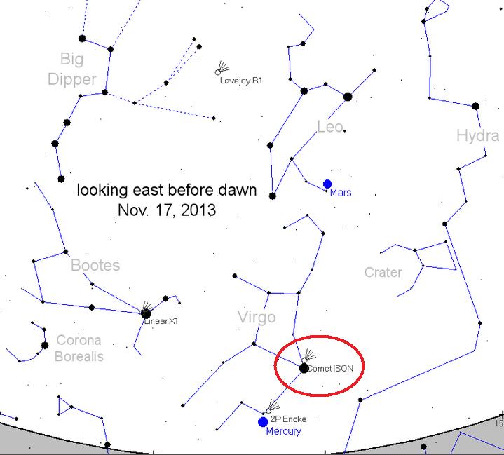
Viewing Map
Here's the viewing map for Comet ISON if you're intersted. Look east just before dawn just off the horizon and you might get lucky!
Deer Camouflage?
Thanks to my good friend Donna Maxie for this picture taken in Hibbing, MN, who says: "You'd only see this on Da Range". HA!

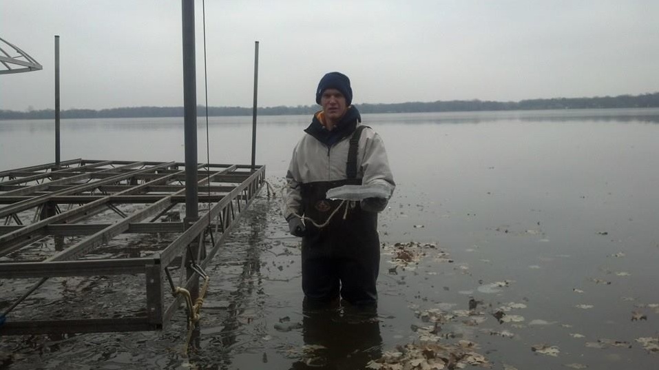
Procrastination Much?
Well, it's about time... At least Saturday was a decently mild day to 'try' to get the dock out. Thanks to my good friend John Ganfield for the picture on Big Elk Lake in Clear Lake, MN. And Yes, that's ice! Minnesota ice is definitly not safe to be walking around on yet, so don't even try it!
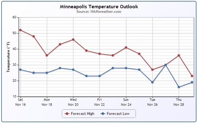
Frequent Fronts
The temperature trend for Minneapolis looks sharply cooler by Monday post front with highs only in the 30s. The good news is that it won't last long as temperatures rebound nicely back into the mid/upper 40s midweek. Cold fronts become the norm through the end of the month as each storm system warms us up (briefly) and cools us down as the storm passes.
Rare November Thunder?
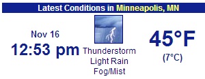
Did see lightning or hear Thunder on Saturday? You're weren't imagining it! A brief line of storms rolled through the Twin Cities around midday with some loud cracks and even a little bit of small hail!
Rare November Thunder Continued...
Even the Twin Cities Airport reported thunder! According to the (1971-2000) Minneapolis averages, the Twin Cities sees less than 1 thunderstorm day in November (0.6 days to be exact).
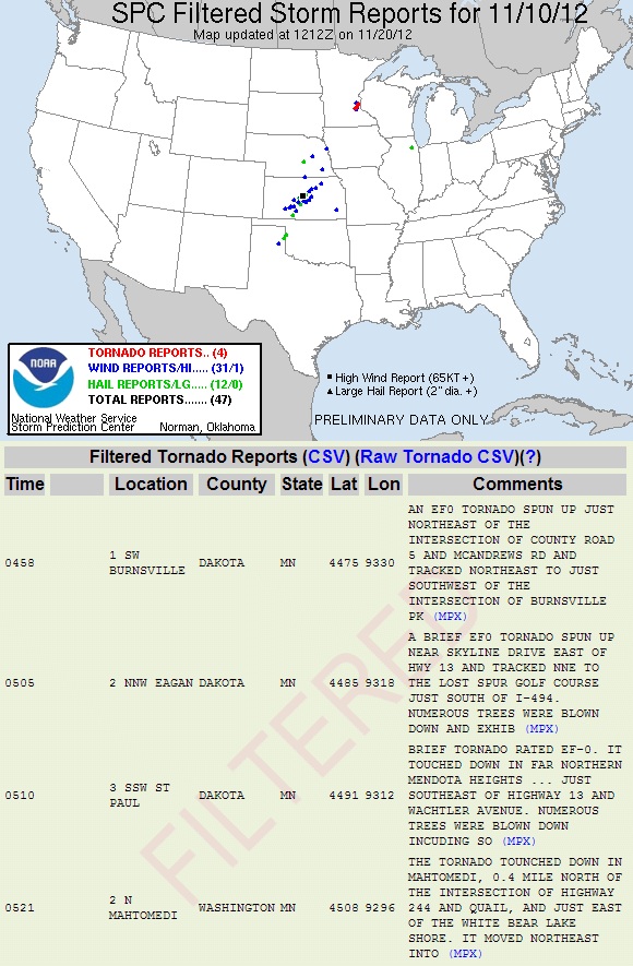
November 10th, 2012
On November 10, 2012, the Twin Cities saw 4 rare tornadoes! The next day it snowed!
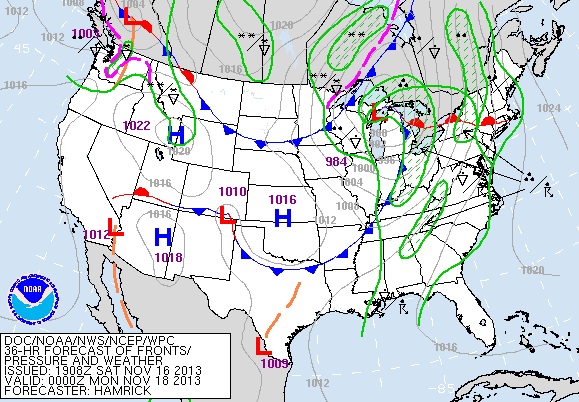
More Rare November Tornadoes?
Sunday could be an interesting day for folks along and just east of the Mississippi River Valley from the Tennessee Valley to the Great Lakes as a potent cold front sweeps east. Damaging Winds looks to be the primary threat, but isolated tornadoes can't be ruled out!
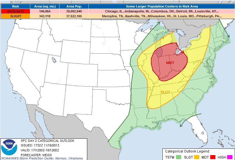
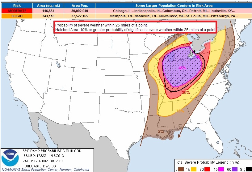
Sunday Severe Probability
Interestingly, there is a fairly high chance (45%) that severe weather will occur within 25 miles of any point in the pink/purple circle below. The hatched area suggests a 10% or greater probability that some of this severe weather could be significant. Stay alert if you are in these areas on Sunday!
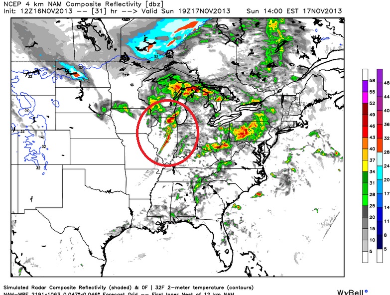
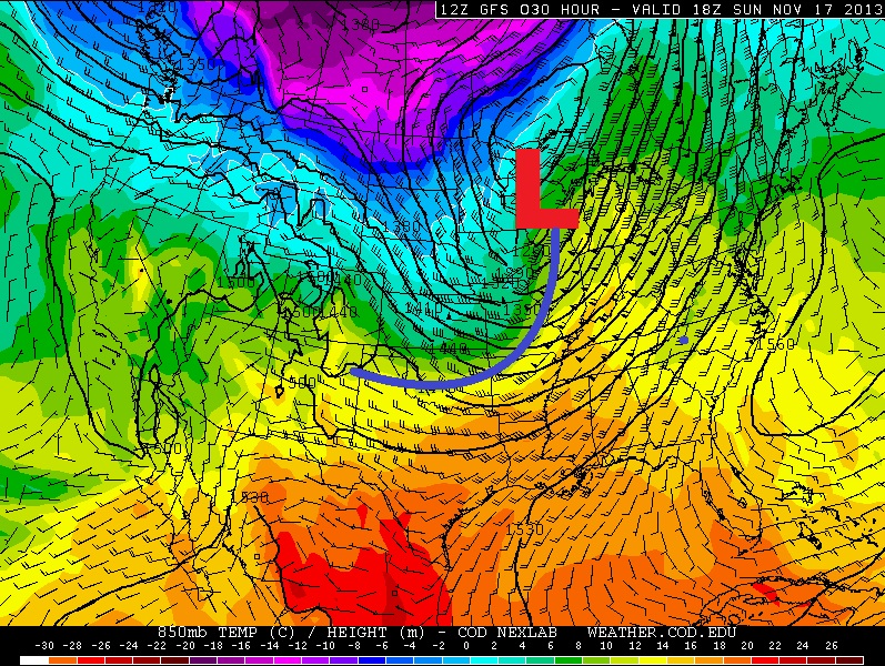
Storm Timeline
The higher resolution 4km WRF shows strong to severe storms breaking out around midday over Illinois. Keep in mind that damaging winds look to be the primary threat, but an isolated tornado can't be ruled out either!
Sunday @1pm
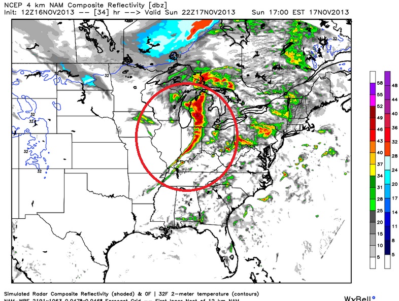
Sunday @4pm
The line looks to intensify quickly as it pushes east through the Great Lakes and Ohio Valley.
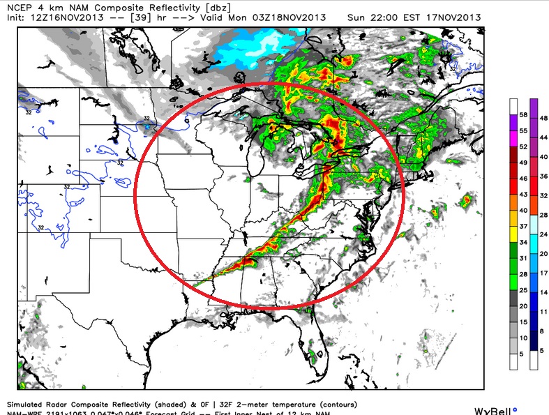
Sunday @7pm
The entire cold front should be kicking out some type of thunderstorm activity by the time the evening rolls around. High winds again will be the primary threat from the eastern Great Lakes down to the Lower Mississippi Valley.
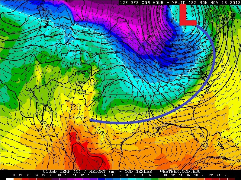
Strong Cold Front
This will be a rather strong cold front with tumbling temperatures post front. In some cases east of the Mississippi Valley, temperatures could drop as much as 20°F from Sunday into Monday!
Strong Cold Front Continued...
Take a look at temperatures across the front from Sunday into Monday. This front will likely have folks grabbing for the coat again!
Midday Sunday Temps
Midday Monday Temps
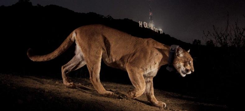
Incredible Shot!
An intrepid photographer spends 14 months trying to get this shot of a mountain lion with the Hollywood backdrop!
"The famous Griffith Park mountain lion will make his debut in National Geographic Magazine any day now. It took photographer Steve Winter 14 months to get this amazing shot with the Hollywood sign as the backdrop (I've heard will be on a two-page spread in the magazine). Learn more about how he made it happen: http://bit.ly/1acsDjb -Ranger Kate K."
See more from the Santa Monica National Mountains Recreational Area Facebook Page HERE:
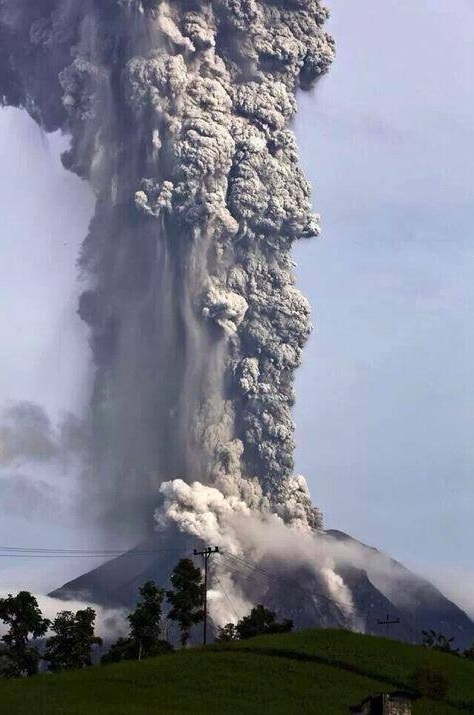
Mt. Sinaburg Eruption
WOW! Take a look at the picture below from a recent eruption from Mt. Sinaburg in Indonesia. This follows an eruption in October, which was the first in 3 years. Interestingly, there was an eruption in 2010, which was the first eruption there in nearly 4 centuries!
"Indonesian officials have warned of a dangerous new eruption of the country's Mount Sinabung volcano, LiveScience reports on Friday. Officials fear that superheated ash and gas coming out of the mountain may indicate that the force of the volcano's eruptions are increasing.
Incredible photos of a massive eruption of the volcano made the rounds on Twitter"
Read more from HuffingtonPost.com HERE:
Thanks for checking in, have a great rest of your weekend
Don't forget to check me out on Twitter @TNelsonWNTV

No comments:
Post a Comment