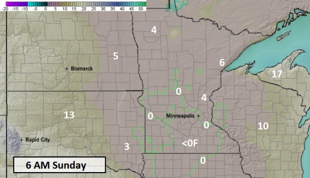
33 F. high in the Twin Cities Friday.
37 F. average high on November 22.
60 F. record high recorded on November 22, 2012.
1.1" snow so far in November.
6" average November snowfall from November 1-22.
 Fresh Air
I
was in Las Vegas last weekend, celebrating the imminent 60th birthday
of a dear friend. No, I didn't gamble. I gamble with the weather and
business on a daily basis - I have no desire to do it "for fun".
We
did stop at The Minus5 Ice Bar, where drinks are served in glasses made
of ice, and everyone huddles around in heavy coats and boots,
complaining about how cold it is. Wait... I could just fly home for the
very same experience, which costs nothing to attend. It dawned on me
that the temperature inside was -5 C, or about 23F.
Really?
By
late January we call that a 'warm front'. If I want to enjoy 23F I can
just go out and have a beer in my garage. There's no cover charge there.
As
I tell new recruits ad nauseum: our coldest days are often sunny, which
helps to remove some of the sting. Nothing worse that really cold AND
really gray.
Under a blue sky the mercury fights its way into the
teens today; outlying suburbs may flirt with 0F late tonight. A lack of
snow on the ground will limit just how low the mercury can tumble.
This
is as cold as it's going to get into early December; 30s return next
week - close to average for Thanksgiving week, with no major storms
close to home. Travelers catch a big break.
An ice storm is
brewing for Dallas and a soaking rain storm sloshes up the east coast
next Wednesday, complicating travel plans from Boston to D.C. to
Atlanta. Travel weather updates on the weather blog.
Flirting With Zero?
NOAA's NAM model shows lows dipping just below zero over the western
and southern suburbs of the Twin Cities, as well as much of central and
southwestern Minnesota. Note that temperatures are forecast to be a
little milder near Lake Superior, the result of relatively warm lake
water being blown downwind over Wisconsin and the U.P. of Michigan. Map:
Ham Weather.
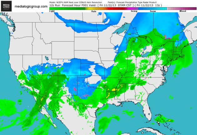
An Active Southern Branch.
The jet stream is increasingly exhibiting a split personality, a cold,
relatively dry northern branch, and a very wet and stormy southern
branch. NOAA's 4km NAM shows a slow-moving storm capable of flooding
rains in Phoenix, 6-10" of snow from Albuquerque to Amarillo and
Lubbock, to glaze ice in Dallas. Note the 200-400 mile long plumes of
lake effect snow extending from the U.P. of Michigan into West Virginia.
Loop: Ham Weather.
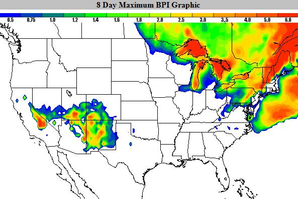
Blizzard Potential Index.
Our modeling expert has come up with a new parameter to measure the
potential for blizzard conditions (35 mph+ winds and visibility under
1/4 mile with falling/blowing snow) over time. Lake effect snows will
create near-blizzard conditions from the U.P. of Michigan into northern
Indiana, the suburbs of Cleveland and Syracuse, while heavy,
wind-whipped snow snarls traffic over the southern Rockies. Map: Ham
Weather.
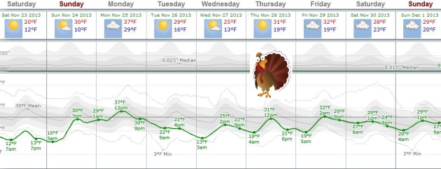
Seasonably Chilly - But Remarkably Quiet For A Major Holiday.
We caught a break this year. No major travel headaches close to home
thru next weekend, temperatures running a few degrees below average, but
today will be as cold as it's going to get looking out 10 days. I don't
see any accumulating snow, highs on Thanksgiving Day in the low 30s,
according to the ECMWF. Graph: Weatherspark.
Talking Travel Turkey.
Will Mother Nature cooperate next week, the biggest travel week of the
year across the USA? No. It's just too tempting a target. Quiet, dry
weather is likely over the Plains, Midwest and Great Lakes, but the same
storm capable of generating a serious ice storm for Dallas and some
6-8" snows for northern and western Texas will track right up the East
Coast, generating heavy, windswept rains, and possibly a period of
slushy snow at the tail end of the storm Wednesday and Wednesday night.
Details in today's edition of
Climate Matters.
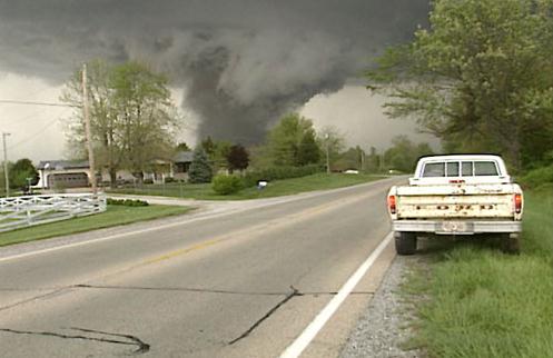
Fewest Minnesota Tornadoes Since 1990. We caught a break last summer, as reported by Dr. Mark Seeley in this week's installment of his
WeatherTalk Newsletter; here's an excerpt: "...
Todd
Krause, Warning Coordination Meteorologist with the NOAA-National
Weather Service in Chanhassen reported this week that Minnesota saw just
15 tornadoes this year, the fewest since 1990 when there were only 12.
The tornado reports by month were: 2 in May; 4 in June; 2 in July; 5 in
August; 1 in September; and 1 in October. The strongest tornado was
rated at EF-2 (winds 111-135 mph) and occurred from 1:50 am to 2:30 am
across Mahnomen and Clearwater Counties, near the town of Zerkel. It was
on the ground for over 21 miles and did some tree damage, but there
were no deaths or injuries. In fact on a statewide basis there were no
deaths or injuries reported due to tornadoes this year..."
Alerts Broadcaster Briefing: Issued midday Friday, November 22, 2013.
*
Coldest air of the season so far will spin up a major snow and ice
storm for the Southern Plains, capable of plowable snowfall amounts over
much of northern, western and central Texas, with a potential for
severe icing Sunday into Monday in the Dallas-Fort Worth area.
*
Major coastal storm brewing for east coast and New England next Wednesday:
mostly rain and high winds with minor coastal flooding possible at high
tide. This system may impact Thanksgiving travel plans and retail
operations.
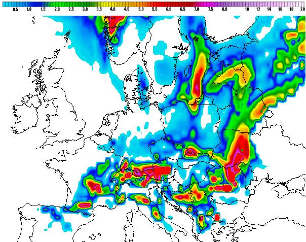
* Significant storm to dump heavy snow on southern France, Switzerland and much of the Alps next 72+ hours.
Converging Ingredients.
I get nervous when a major blast of arctic air is approaching the U.S.
In today's scenario the thrust of that Canadian air is pushing south,
across the Plains, where it will help to spin up a storm rich in
moisture from the Gulf of Mexico. The result, heavy, wet snow for much
of central Texas, including Lubbock, Midland, San Angelo and Wichita
Falls, extending into southern Oklahoma. Norman and Oklahoma City may
experience as much as 3-5" of snow this weekend, with hazardous travel
conditions extending into Monday.
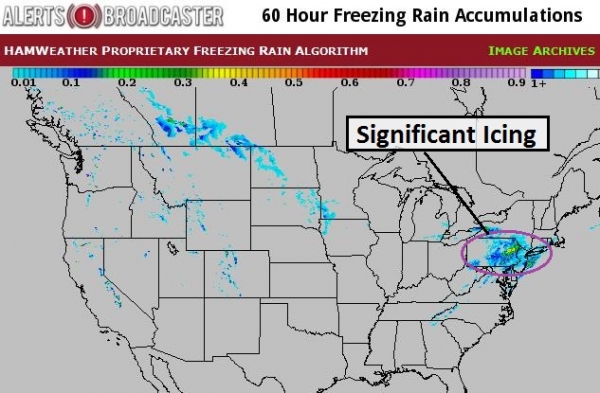
Ice Storm Potential.
Snow is one thing, but glaze is an altogether larger overall risk to
staff, customers and facilities. Our models print out over 1" of liquid
precipitation in the Dallas area by Monday. Although a thin layer of
warm air aloft may keep precipitation falling as rain, by Sunday that
rain may be freezing on contact with cold surfaces: roads, sidewalks and
powerlines, creating an icy coating capable of major impacts. Snow will
mix in, especially the Fort Worth suburbs, but
I'm more worried about extreme ice conditions capable of shutting down travel and impacting the local power grid. Map above: NOAA.
NAM Solution.
NOAA's NAM model shows more snow than ice for much of northern and
central Texas. I'm skeptical. Although the lowest mile of the atmosphere
should be cold enough for mostly snow from Wichita Falls to Abilene,
San Angelo and Lubbock, enough warm air may mix into the storm's
circulation aloft for an icy mix from near Waco into Dallas - Fort
Worth. A few spots in from the Texas Panhandle into northern Texas and
southern Oklahoma could pick up in excess of 6-8" of snow, mixed with
sleet (ice pellets) at times. For Dallas precipitation may fall as
mostly freezing rain - capable of a severe glaze icing event.
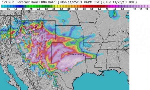
Predicted Amounts.
The same icy blast will spark lake effect snows from Green Bay to near
Gary and South Bend, Indiana, and the snow belts around Cleveland,
Syracuse and Rochester, New York may see enough snow to shovel and plow.
Check out some of the snowfall tallies for Texas, as much as 9" for
Amarillo, even 2-3" at El Paso, on the Mexican border. Pretty amazing
for late November.
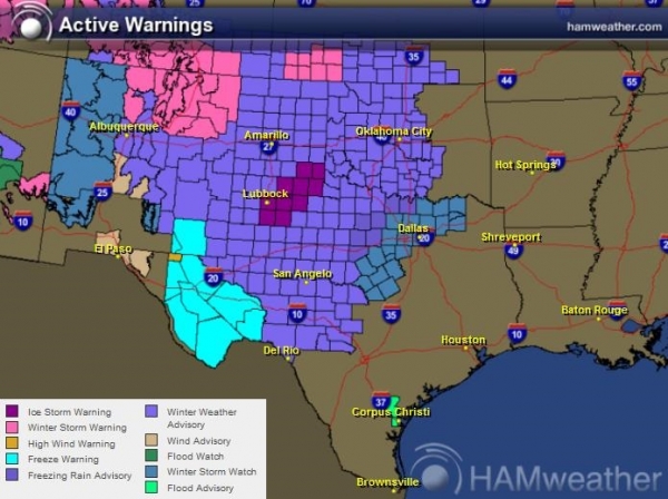
Current Watches and Warnings.
An Ice Storm Warning is already posted around Lubbock - my hunch is
that this may be extended east into the Dallas area as we head into the
weekend. Right now Dallas is under a Winter Storm Watch from Sunday
morning into midday Monday. Expect rain today and much of Saturday; the
real concern is Sunday night into Monday morning, as temperatures fall
below freezing and that rain begins to freeze on contact.
I could see
substantial power outages across north Texas and southern/western
Oklahoma late in the weekend into Monday as tree branches freeze and
topple, taking powerlines with them. Albuquerque, New Mexico may pick up as much as 4-7" of snow from this system as well. Map above: Ham Weather.
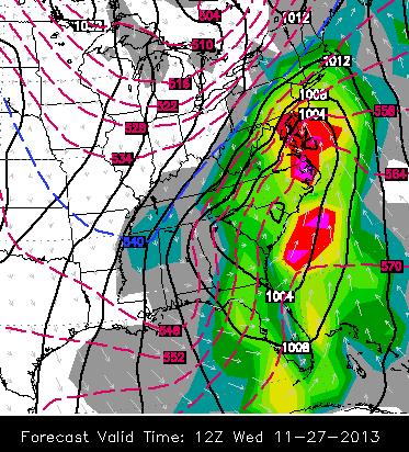
Thanksgiving Travel Grinch.
Short term the concern is the Southern Plains with heavy snow and ice.
Next week a fresh surge of Canadian air will whup up a major coastal
storm. Temperatures aloft should we warm enough for (heavy) rain from
Boston to New York, Philadelphia, D.C., Charlotte and Atlanta, with a
period of wet snow inland at the tail end of the storm Wednesday night.
The combination of heavy rain and embedded T-storms may hamper travel by
land and air next Wednesday along much of the eastern seaboard. You've
been warned. ECMWF map valid 6 AM EST Wednesday, November 27 via WSI.
On The Other Side Of The Pond.
Our Alerts Broadcaster models print out some 5-8" snowfall amounts near
Toulouse, France, with plowable amounts expected from Geneva to Zurich
and much of the Alps. We'll continue to monitor this storm for our
clients with operations across Europe.
Summary:
the greatest short-term concern is heavy snow from New Mexico and
northern/western Texas into western and southern Oklahoma. Traffic will
be impacted - so will facilities. I'm even more concerned about a
potential for a MAJOR ice storm impacting Dallas - Fort Worth and Waco,
with some half inch accumulations of glaze ice on some roads, trees and
powerlines. The greatest window of concern is Sunday afternoon into
midday Monday.
A major east coast storm will push heavy rain and a
few T-storms from the Carolinas into New England next Wednesday. This
looks like primarily a rain storm (with some coastal flooding and beach
erosion possible), a brief period of wet snow possible at the tail-end
of the system, but probably no major accumulation from Boston to New
York to Washington D.C. We'll be watching this system very carefull in
the coming days. Stay tuned for more updates.
Paul Douglas - Senior Meteorologist - Alerts Broadcaster
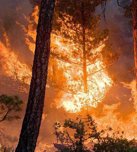
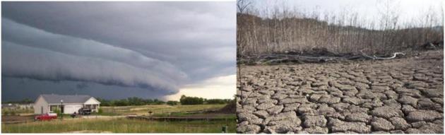
Wildfire Risk Seen As High or Extreme At 4.5 Million U.S. Homes. Bloomberg and
The Chicago Tribune have the article; here's the introduction: "
More
than 4.5 million U.S. homes are at high or extreme risk from wildfires,
led by properties in California, according to Verisk Analytics, the
supplier of actuarial data to insurers and banks. California has 2
million properties meeting those risk designations, followed by Texas
with 1.3 million and Colorado with almost 374,000, Verisk Insurance
Solutions said today in a report. Higher temperatures and increased
development near forested areas have increased costs from U.S.
wildfires. This year 19 firefighters known as the Granite Mountain
Hotshots died battling a blaze in Arizona. Colorado wildfires have cost
insurers more than $1 billion since 2010, including the Black Forest
fire this year, Verisk said..." (File image: U.S. Forestry Service).
Forget Concrete - The Way To Block Tsunamis Is These Spindly Trees.
Using (natural) buffers, like sand dunes or even trees can slow the
advance of not only earthquake-generated tsunamis, but typhoon-related
storm surges. Here's a clip and animation from
Quartz: "...
Some
of Haiyan’s destruction could have been prevented. But not with
seawalls or dykes—with mangrove trees. Areas near Tacloban where mangrove forests hadn’t been illegally cut
fared better, as a Philippines development consultant told Bloomberg.
That’s because mangroves provide a natural buffer that slows down inland
tidal surges, absorbing 70-90% of a normal wave’s impact. Here’s an animated version of how mangrove forests dampen a tsunami’s force..."
Why The Philippines Shouldn't Rebuild Storm-Ravaged Tacloban.
I fear we'll be having similar discussions for other coastal
communities in the years ahead, as rising sea levels combine with
increasingly severe typhoons, hurricanes and nor'easters. When do you
just throw up your hands and admit that it doesn't make dollars and
sense to keep rebuilding in the same vulnerable areas? Here's an excerpt
from
Quartz: "...
Rebuilding
“needs to be done urgently and differently for the Philippines,” Vinod
Thomas, director general for independent evaluation at the Asian
Development Bank, told Quartz. “There is clearly a big lesson to be
learned in not relocating in a highly vulnerable area,” he said.
“Tacloban is like a poster child. You can’t imagine a more vulnerable
area than Tacloban.” All of the Philippines is vulnerable to rising seas and intense storms caused by climate change, but Tacloban—situated at the mouth of a bay and with major portions of the city well below sea level—is in a uniquely precarious position..."
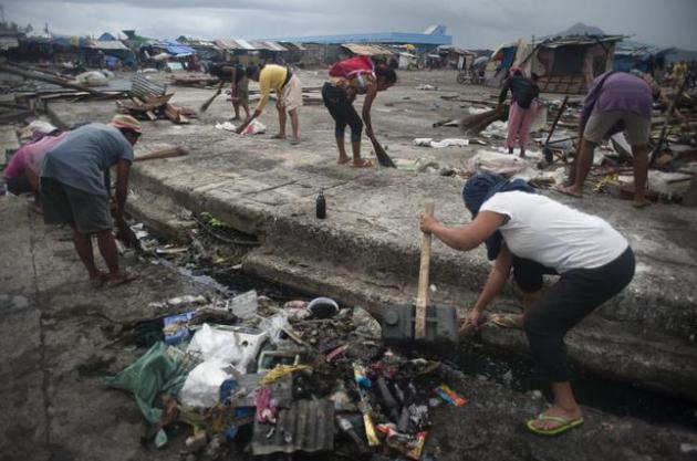
Photo credit above: "Locals
clean up debris on a street in Tacloban, Philippines, Nov. 22, 2013.
Typhoon Haiyan, which cut a destructive path across the Philippines, is
believed by some climatologists to be the strongest storm to make
landfall in recorded history, with some 13 million people affected by
the storm." (Jes Aznar/The New York Times).

Jimmy Breslin On JFK's Assassination: Two Classic Column.
I think it's hard for most of us to wrap our brains around how
traumatic it must have been in this nation 50 years ago. I was 5, and I
vaguely remember sitting in my kid-size rocking chair, crying, because
my parents were crying. But I couldn't really comprehend what had
happened. Here's an excerpt from a couple of must-read columns at
The Daily Beast: "
In
the days after President Kennedy’s assassination, the legendary
columnist Jimmy Breslin set the standard for literary journalism written
in the wake of tragedy. His columns for the New York Herald Tribune
became instant classics, precisely because he chose to cover the
unexpected human stories at the heart, but on the periphery, of the
breaking news. Published here with Breslin’s permission are two of his
iconic columns from those tumultuous days. “A Death in Emergency Room
One” chronicles Nov. 22, 1963, from the attending emergency-room surgeon
in Dallas. “It’s an Honor” has become a staple of journalism schools
because Breslin sidestepped the media circus and covered the president’s
burial from the perspective of the gravedigger at Arlington National
Cemetery. Taken together, these two columns are true short stories,
history written in the present tense..."
Photo credit above: "Members
of the U.S. Naval Academy Men's Glee Club sing at the "The 50th:
Honoring the Memory of President John F. Kennedy" event in Dallas on the
50th anniversary of the president's assassination, Friday, Nov. 22,
2013." (Rodger Mallison/Fort Worth Star-Telegram/MCT)
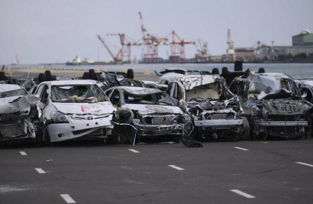
How The Japanese Tsunami Changed The U.S. Auto Industry. Here's an excerpt from an interesting story (and twist) via
CBS News MoneyWatch: "
As
we near the first anniversary of the tragic earthquake and tsunami that
hit Japan on March 11, its effects linger not only in that country but
also in the American auto industry. The disaster disrupted supplies of
made-in-Japan models like the Toyota Prius and Honda Fit, as well as the
flow of parts for some cars assembled in the U.S. As a result, shoppers
who might have bought a Toyota or Honda last year bought Chevrolets and
Fords, as General Motors and Ford gained market share..."
File Photo credit: AP Photo/Wally Santana
Michael Jordan's North Shore Mansion Goes Under The Auction.
The auction took place yesterday, but I thought some of you might want
to see the details of Air Jordan's pad, which is pretty amazing, in a
wretched-excess sort of way. Here's an excerpt from
The Chicago Tribune:
"Michael Jordan’s 56,000-square-foot mansion in Highland Park —
complete with an NBA regulation-size basketball court — will be put up
for sale during a live auction Friday. No minimum bid has been set for
the basketball superstar’s 7.4-acre estate at 2700 Point Lane, but
prospective buyers are required to put down a $250,000 deposit just to
participate in the bidding, said Laura Brady, president of New
York-based Concierge Auctions..."
Photo credit above: "The living room inside Michael Jordan's 56,000-square foot Highland Park estate." (John S. Eckert Photography, John S. Eckert).
TODAY: Chilled sunlight - coldest day yet. Feels like 0 at times. Winds: NW 15. High: 19
SATURDAY NIGHT: Clear and plenty cold. Low: 3
SUNDAY: Dim sun, breezy and not as nippy. Winds: S 10-15. High: near 30
MONDAY: Partly sunny, above average temperatures. Wake-up: 27. High: 36
TUESDAY: Blue sky, colder again. Wake-up: 18. High: 24
WEDNESDAY: Fading sun, good travel weather. Wake-up: 13. High: 26
THANKSGIVING DAY: Some sun. Risk of turkey. Wake-up: 19. High: 32
FRIDAY: Partly sunny and dry. Rabid Shopper Alert. Wake-up: 21. High: 33
Climate Stories....
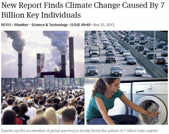
The Onion Nails It.
This is in response to the recent "90 companies blamed for 2/3rd's of
greenhouse gas emissions" story. These companies are just giving us what
we want and need, right? Graphic:
The Onion.
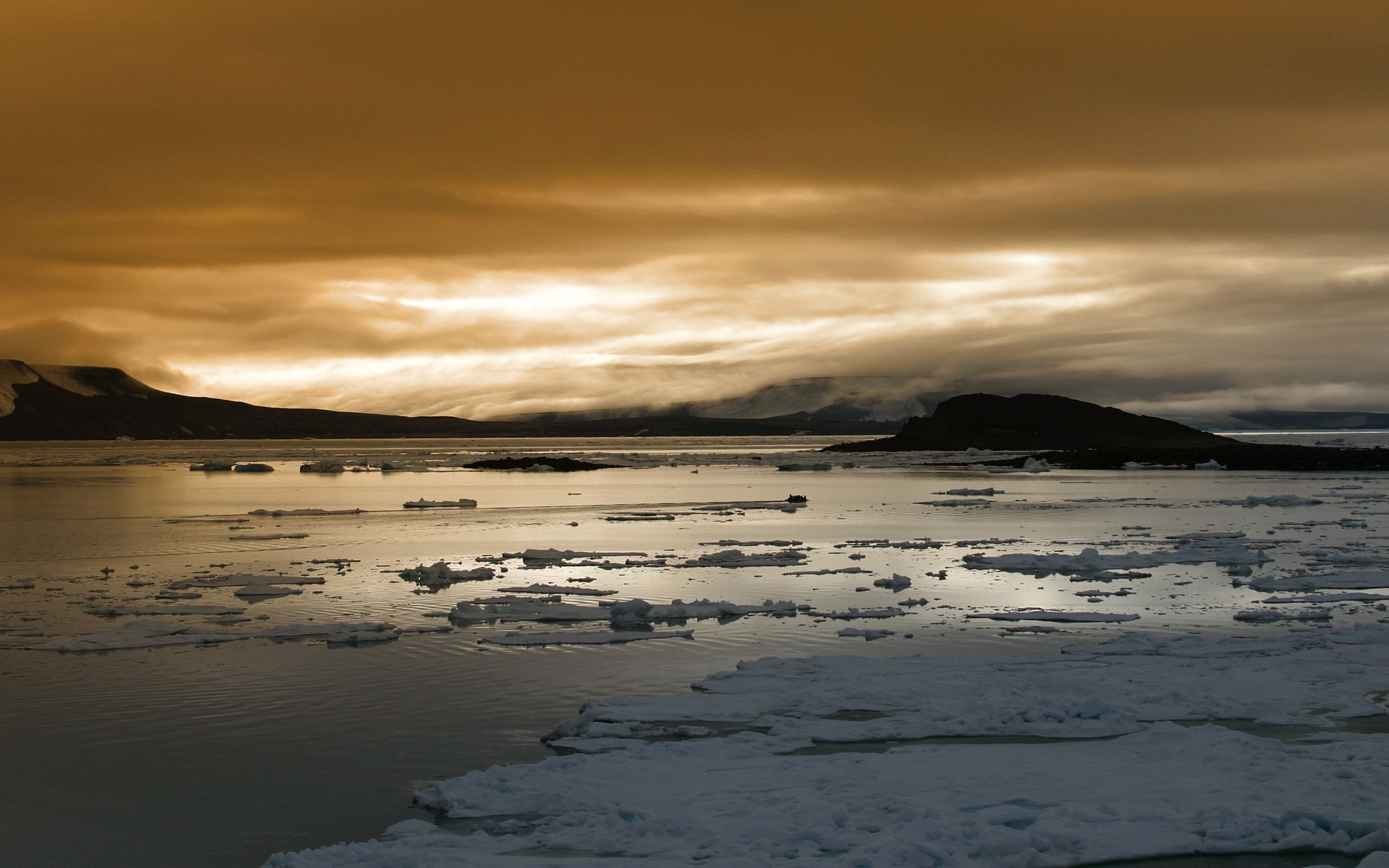
Pentagon Releases Strategy For Arctic.
A rapidly melting arctic ice cap is pretty hard to ignore (or deny),
yet many of the same professional climate deniers are happy to point out
the advantages of less ice and more water - more economical shipping,
and more exploration for oil and gas. Of course it's all that burning of
oil and gas that's melting the polar ice cap in the first place. Oh,
the irony. Here's a clip from
The New York Times: "...
While “climate change
does not directly cause conflict,” Mr. Hagel said, it may
“significantly add to the challenges of global instability, hunger,
poverty and conflict.” He cited “food and water shortages, pandemic
disease, disputes over refugees and resources, and more severe natural
disasters.” The Pentagon’s Arctic strategy places a priority on
preparations to detect, deter, prevent and defeat threats to the United
States even as the nation “will continue to exercise U.S. sovereignty in
and around Alaska,” Mr. Hagel said..."
Climate Change Forces New Pentagon Plan. Picking up on Secretary of Defense Hagel's comments, here's an excerpt of a slightly different perspective from
U.S. News and World Report: "
The
Arctic is covered with pure driven snow. The Department of Defense
hopes to keep it that way with a new policy that for the first time
addresses how the U.S. will respond to the effects of climate change,
which have opened up a veritable treasure trove around the North Pole
that until recently was inaccessible. Defense Secretary Chuck Hagel
unveiled the military's new Arctic Strategy Friday afternoon during his
trip to Canada. The plan seeks to head off potential tensions in the
crowded Arctic neighborhood among its residents -- most notably Russia,
but all eager for access to massive oil reserves and newly thawed
passages for shipping, fishing and tourism..." (Photo credit: NOAA).
U.N. Climate Talks Near End, With Money At Issue. Here's an excerpt from a summary at
The New York Times: "
The
United Nations climate conference ambled toward a conclusion on Friday,
with delegates saying that the meeting would produce no more than a
modest set of measures toward a new international agreement two years
from now. As usual, the biggest dispute was over money. The talks, the
19th annual meeting of parties to the United Nations Framework Convention on Climate Change,
opened nearly two weeks ago in the shadow of a devastating typhoon in
the Philippines. The disaster added momentum to a proposal by poorer
nations for the creation of a new mechanism to compensate developing
countries for damage from climate-related disasters..."
As U.N. Climate Change Talks Go Nowhere, Ontario Bans Coal. This made me do a double-take; here's a clip from a story at
The Atlantic: "
While
delegates to the United Nations Climate Change Conference in Warsaw
continued fiddling while Rome burns, the government of Ontario, Canada,
today moved to permanently ban coal-fired power plants.
“Our work on eliminating coal and investing in renewables is the
strongest action being taken in North America to fight climate change,”
Kathleen Wynne, the premier of Ontario, said in a statement. Wynne’s
government next week will introduce the Ending Coal for Cleaner Air Act
in Parliament. Unlike most such legislation, the Act will ratify what
the government has already done – close down the coal-fired power plants
that once supplied a quarter of the province’s electricity..." (Image credit: Reuters).
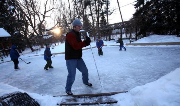
Why America's Major Sports Leagues Are Talking About Climate Change. Ice hockey is already being impacted (shorter seasons on America's ponds and lakes). Here's a clip from a story at
ThinkProgress: "...
But
those kids are starting to run into a major problem: the frozen ponds
they play on are less and less likely to form each winter, as a changing
climate makes winter warmer and open ice more scarce. That isn’t just
bad news for kids who want to play the game. It’s also worrisome for the
National Hockey League, a league already a distant fourth among
America’s top four professional sports that depends on those pickup
games and frozen ponds to help build new generations of fans and
players. And the NHL isn’t alone. The NFL, NBA, Major League Baseball,
and WNBA are all worried about the effects of environmental changes on
their sports and the people who play them, which is why representatives
from those five leagues plus the U.S. Olympic Committee joined Sen.
Sheldon Whitehouse (D-RI) and Rep. Henry Waxman (D-CA) on Capitol Hill
today to discuss their efforts to reduce energy usage and address
climate change — and the efforts the federal government could take to do
the same..." (File photo credit: Star Tribune).
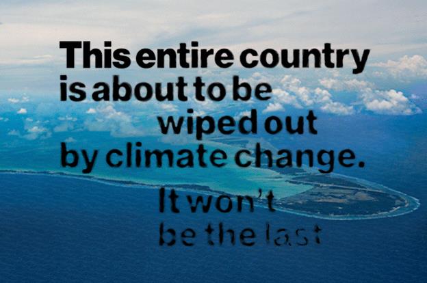
This Entire Country Is About To Be Wiped Out By Climate Change. It Won't Be The Last. Here's an excerpt from a sobering story at
Bloomberg BusinessWeek: "...
Kiribati
is a flyspeck of a United Nations member state, a collection of 33
islands necklaced across the central Pacific. Thirty-two of the islands
are low-lying atolls; the 33rd, called Banaba, is a raised coral island
that long ago was strip-mined for its seabird-guano-derived phosphates.
If scientists are correct, the ocean will swallow most of Kiribati
before the end of the century, and perhaps much sooner than that. Water
expands as it warms, and the oceans have lately received colossal
quantities of melted ice. A recent study found that the oceans are
absorbing heat 15 times faster than they have at any point during the
past 10,000 years. Before the rising Pacific drowns these atolls,
though, it will infiltrate, and irreversibly poison, their already
inadequate supply of fresh water..."
Photograph by Claire Martin for Bloomberg Businessweek.
Achbishop Urges Steps To Address "Ethical Challenge" Of Climate Change.
The Catholic Sentinel in Portland, Oregon has the story - here's the introduction: "
Climate
change represents an "ethical challenge to civilization," said the
Vatican's lead representative to an international conference discussing
the worldwide impact of climate change. Archbishop Celestino Migliore
told attendees at a church-run conference that the Vatican would help
"form consciences and ethical perspectives" on climate change in line
with Catholic social teaching and encourage "fairness, impartiality and
mutual responsibility" when it came to action to address the
environmental threat..."
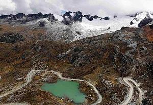
Photo credit above: Catholic News Service photo. "
A view of a glacial lake is seen in Juascaran National Park in Peru in late September."
Harvard Can Save Us From Global Warming Apocalypse.
Divestment (of fossil fuel holdings) is one way to plant a flag in the
ground and inspire other universities, companies and individuals, as
argued in this collaboration between TomDispatch.com and
Salon; here's a clip: "...
Set
against a landscape in which people have lost faith in the principle
sectors of power, however, universities still have a certain legitimacy
that grants them the potential for leverage. Divestment will make news
precisely because such movements are unusual: universities biting the
hands of the dogs that feed them, so to speak. We won’t know how much
influence that legitimacy can bring about until the attempts are made.
What we do know, from historical precedent, is that such efforts, even
when they start on a small scale, tend to inspire more of the same..."


No comments:
Post a Comment