By Paul Douglas
My nervous tick is back, and for good reason. Storms, given a choice, prefer to come on major holidays. Especially Thanksgiving.
As winters inexorably shrink the first snowy shrieks from Old Man Winter are often delayed until
late November. Not every year but many years. I get nervous when the weather is too quiet and too mild for too long.
The analogy I use is a balloon. Cold, Canadian air is filling up that balloon over time. If you let some air out of the balloon (cold frontal passages) all is well. Otherwise the balloon inflates & pops dramatically: a surge of bitter air capable of spinning up a major snowstorm.
I still don't see that scenario playing out the next 2 weeks, as prevailing steering winds aloft blow from Vancouver, instead of the Yukon - limiting just how cold and snowy it can get anytime soon.
Expect light rain today; showers tapering tomorrow behind a cold front - a slushy inch for the Red River Valley but no snowy roads for the Twin Cities.
After peaking near 50F midweek another cold front has us reaching for heavy jackets late next week. I don't see any weather-drama into Thanksgiving weekend.
Will the balloon finally burst in December? Probably.
___________________________________________________________________
SATURDAY: Periods of light rain and drizzle. Rumble of PM thunder in southeastern MN? Winds: SE 10-20. High: 50.
SATURDAY NIGHT: Lingering light rain possible. Low: 42.
SUNDAY: Heavier/steadier rain pushes east into Wisconsin. Turning windy and cooler. High: 48. Winds: W 15-30.
SUNDAY NIGHT: Changeover to a little light snow. Still windy, turning colder. Low: 29. Winds: W 15-30
MONDAY: Slow clearing, cold wind. High: 31 (windchill in the teens)
TUESDAY: Bright sun, not as breezy or as chilly. Wake-up: 26. High: 44
WEDNESDAY: Clouds thicken, slight chance of a light rain late? Wake-up: 39. High: 50
THURSDAY: Dim sun. Maybe a few sprinkles? Wake-up: 31. High: 45
FRIDAY: Mostly cloudy. Slight chance of light rain/snow late. Wake-up: 32. High: 41
____________________________________________________________________
This Day in Weather History
November 16
1933: Record lows were set in a few locations including Farmington with a low of 11 degrees below zero, Little Falls at 10 degrees below zero, Chaska at 9 below and Milaca at 8 degrees below zero.
1931: Tornado near Maple Plain in Hennepin County. Path of storm was five miles long.
____________________________________________________________________
Beavers At Work?
How much wood can a beaver chuck? I don't know, but I hope it's not a lot because these trees outside of our office are looking pretty rough. With the wrong wind gust, these babies could come tumbling down. Several cones have been placed in the parking lot already... I hope Paul Bunyan is on his way down from Bemidji to take care of these trees. I guess it makes sense, the full moon this Sunday is actually called the full beaver moon... no joke!

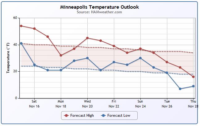
Minneapolis Temperature Outlook
Get your outdoor chores done when you can before it's too cold or before the snow flies. It's just a matter of time before we're up to our knees in snow and sub-zero wind chill values become the norm. Despite the rain chances this weekend, you might still be able to get a few things done; i.e. get the shovels out of the shed or make sure the snowblower works. According to some extended model runs, we'll see a gradual decrease in temperatures through the end of the month, which is no surprise. Note the sharp temp drop by Monday post cold front Sunday.
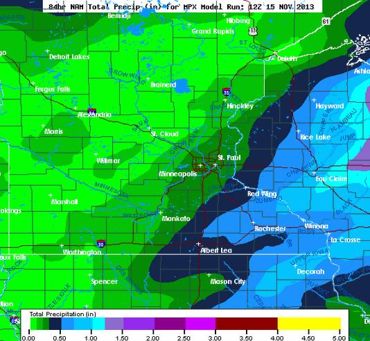
Minneapolis Precipitation
It appears that the heaviest precipitation this weekend will be shunted east into Wisconsin and the Great Lakes Region. Some of this moisture will be convective in nature, which means there could be a bit of thunder (mainly east/southeast of the Twin Cities).
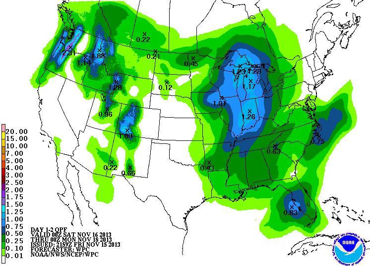
Weekend Precipitation
According to NOAA's HPC precipitation forecast for the weekend, there a better chance of heavier precipitation over the Ohio Valley and Great Lakes Region, just east of the Mississippi Valley. Keep in mind that most of this moisture will be in the form of liquid as temperatures are expected to be rather warm ahead of the potent cold front.
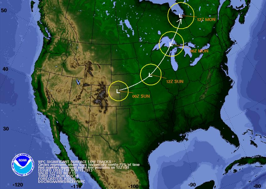
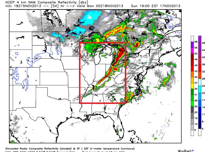
Tracking Our Next Storm
Here's our latest storm system that will be tracking through the Midwest over the weekend. Rain and somewhat stormy weather will be possible on the southeast side of the storm Saturday and Sunday (some storms may be severe). There is also the possibility of some snow on the colder, northwest side of the storm as it blows through. The temperature swing as the storm passes will be pretty dramatic, so get ready for a wild weekend!
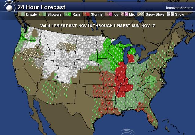
Weekend Weather
The forecast map below looks a little messy, but it shows the weather potential from 1pm Saturday to 1pm Sunday. Note the potential stormy outlook on the warmer southeast side of the low and the snow potential on the northwest side of the storm.
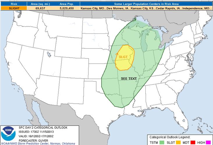
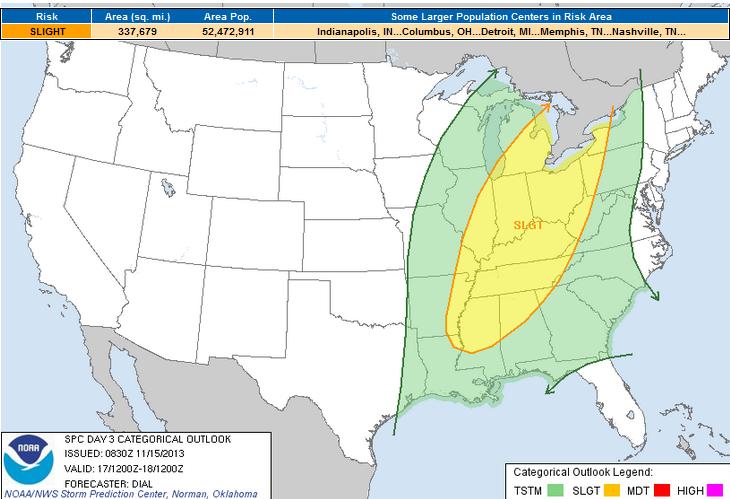
Severe Threat
This potent area of low pressure will likely draw up enough warmth and instability for some strong to possibly severe thunderstorms from the Midwest to the Ohio Valley Saturday into Sunday. The Storm Prediction Center has already issued a SLIGHT RISK of severe weather for both days this weekend. Keep an eye on weather conditions if you live in these areas.
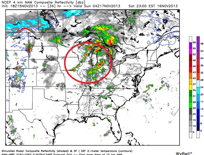
Saturday Threat
The higher resolution 4km WRF model suggests a somewhat stormy scenario unfolding by the later PM hours of Saturday across parts of the Midwest.
Sunday Threat
The higher resolution 4km wrf suggests a fairly robust line of storms developing during the PM hours of Sunday across the Mississippi Valley into the Ohio and Tennessee Valley. This will most likely be conducive of stronger straight line winds.
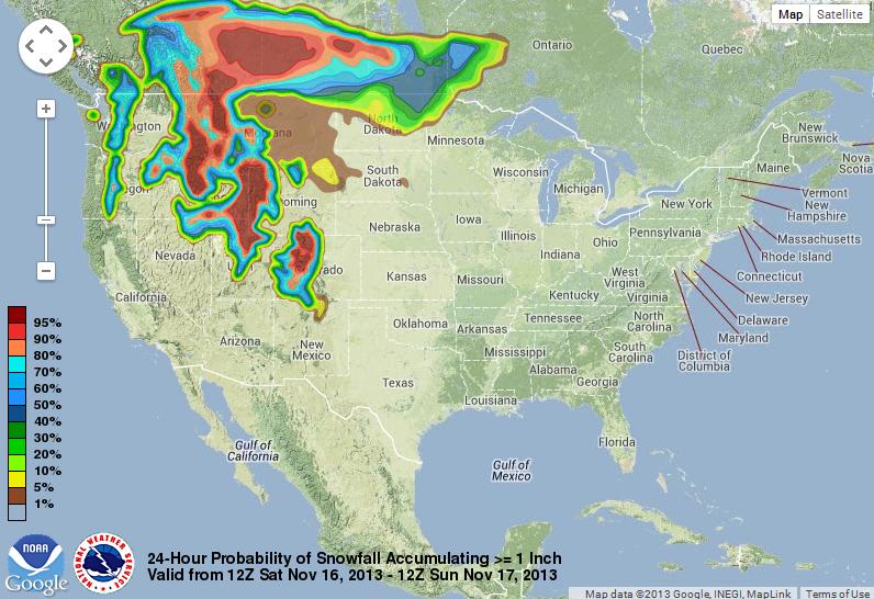
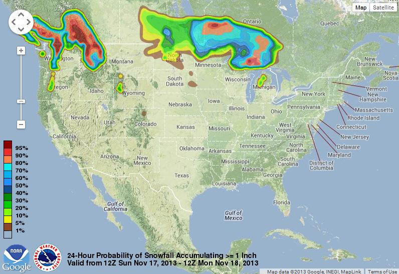
Snow Chances
Here are some interesting maps from NOAA. These are snow probability maps for snow amounts greater than or equal to 1". As you can see, other than those in the western mountain locations and those along the immediate international border with Canada, there isn't a great shot for widespread snow across the lower elevations of the U.S. due to temps being to warm as this storm moves east.
Saturday: Probability of Snow Greater Than or Equal 1"
Sunday: Probability of Snow Greater Than or Equal to 1"
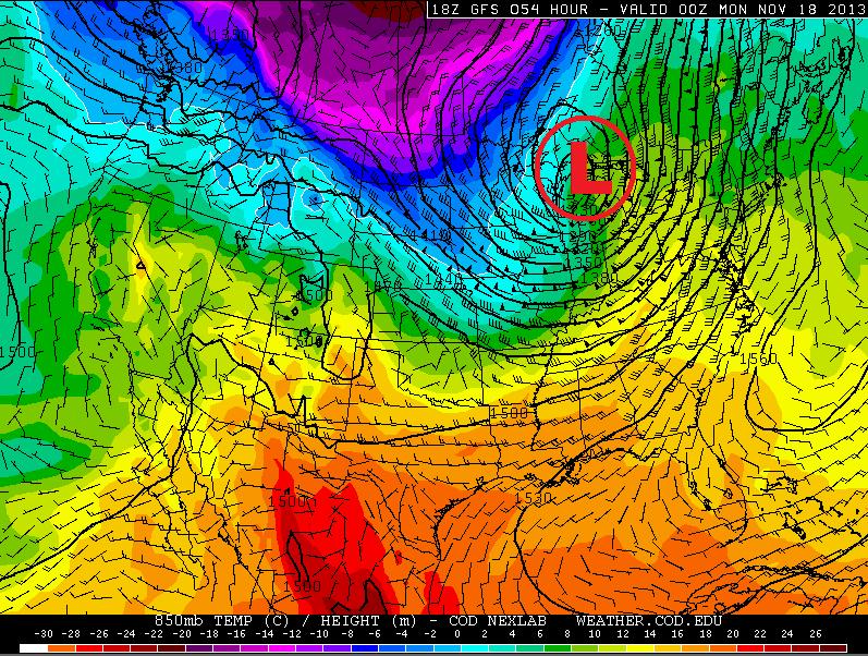
Turning Windy & Colder Sunday
That's quite a low wrapping up over the Great Lakes on Sunday, isn't it? The wind field surrounding it will be quite impressive as well, especially Sunday when the cold air stars wrapping in on the backside of the cold front.
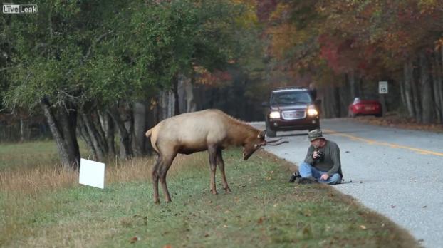
Elk vs. Photographer
Now I've seen just about everything! Glad this photographer was OK.
Source: While photographing elk at sunrise in the Cataloochee Valley of Great Smoky Mountains National Park I turned around to see what appeared to be just a curious young bull sniffing a photographer's camera. I snapped a few frames of the apparent harmless encounter
See the video from LiveLeak.com HERE:
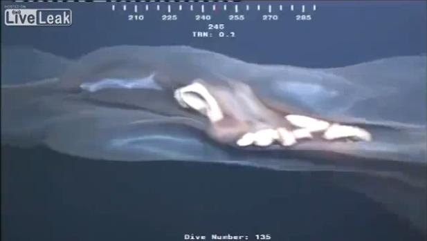
Unidentified Sea Monster?
Here's another one from LiveLeak.com - this was video taken from an oil rig cam. I have no clue what this could be, but it's further verification that the ocean FREAKS me out! There are so many wierd/potentially human eating things that are in the water... I dunno, maybe I watched Jaws one too many times as a young kid.
See the video HERE:
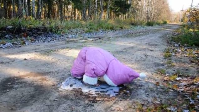
Cuteness Overload
After that creepy video above, you probably need a little something to warm your heart. How about this video of a little girl's first time walking on ice. Should be on Funniest Home Videos!
See the video from Gawker.com HERE:
Thanks for checking in and have a great weekend ahead.
Don't forget to follow me on Twitter @TNelsonWNTV

No comments:
Post a Comment