By Todd Nelson
If there was such a thing as an atmospheric dunk tank, an Arctic one, then this next multi-day event would be it! I hate to say it, but our next winter slap is going to hurt a little.
An Arctic front arrives late Saturday with a light wintry mix and gusty winds. Don't be surprised if your windows rattle a bit overnight as the colder air surges into the region. Daytime highs Sunday will likely fall much of the day with overnight lows Sunday rivaling that of the coldest low of the season so far (-13F on Christmas Eve).
It doesn't get much better as we say goodbye to 2013; bundle up if you have plans to watch the clock strike midnight. The good news is that we may actually climb above 0F by New Year's Day!
Between the cold and clippers this week, I'm sure there will be several folks searching travel websites for the next flight south. I'm starting to envy my parents for becoming recent snowbirds; wintering down in Arizona. They like to call and remind me that they don't have to shovel or put an exorbitant amount of clothing on just to get the mail.
It's not like we haven't been through this before, right? Just keep calm and weather the Arctic dunk tank.
_______________________________________________________________
SATURDAY: Still mild early, enjoy! Clouds increase with a light wintry mix late. High: 35. Wind: E 5-10.
SATURDAY NIGHT: Clouds, flurries and a harsh wind, turning much colder. Low: -3
SUNDAY: Another Canadian invasion. Brisk with some sun. High: -3
SUNDAY NIGHT: Coldest night of the season? Low: -16
MONDAY: Patchy clouds and flurries. Feels like -25F. High: 0
TUESDAY: New Year's Eve. Bright arctic sun, less wind. Wake-up: -14. High: -2
NEW YEAR'S EVE NIGHT: Chance of light snow, still very cold. -10. Feels like -20F
WEDNESDAY: Light snow continues early. Still mostly-frozen. High: 7
THURSDAY: Breezy and milder Much better. Wake-up: -4. High: 5
FRIDAY: Warmer with a chance of snow. Wake-up: -2. High: 12.
_________________________________________________________________
This Day in Weather History
December 28th
2000: Central and southeast Minnesota received 6 to 10 inches of snow. Some notable snow amounts include: Chanhassen NWS Forecast Office with 7.8 inches, St Cloud with 7.5 inches, and Hutchinson, Willmar, Albany, Red Wing, and Long Prairie with 7.0 inches.
1979: Balmy weather enables city park crew in Duluth to rake leaves.
1927: Cold snap across Minnesota. Temperature falls from 41 to -15 at Farmington.
_____________________________________________________________________
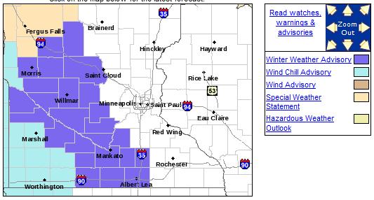
Arctic Front Arrives PM Saturday
The National Weather Service has issued a Winter Weather Advisory from 6 PM Saturday to 6 PM Sunday for blowing snow and bitterly cold wind chills that will have an impact on travel. Strong winds could actually create near blizzard conditions in rural areas during that time.
...DANGEROUS WIND CHILLS AND BLOWING SNOW DEVELOPING SATURDAY AFTERNOON AND EVENING...
AN ARCTIC COLD FRONT WILL MOVE QUICKLY SOUTHWARD ACROSS WEST CENTRAL MINNESOTA SATURDAY AFTERNOON THEN THROUGH ALL OF SOUTHERN MINNESOTA BY EARLY SATURDAY EVENING. BEHIND THIS FRONT TEMPERATURES WILL PLUMMET INTO THE SINGLE DIGITS BELOW ZERO BY SUNSET IN WEST CENTRAL MINNESOTA...AND ACROSS SOUTHERN MINNESOTA BY LATE SATURDAY EVENING. IN ADDITION...BLOWING AND DRIFTING SNOW WILL DEVELOP...CREATING LOCALIZED WHITE OUT CONDITIONS. WIND SPEEDS WILL AVERAGE 30 TO 35 MPH WITH GUSTS OVER 45 MPH IN WEST CENTRAL MINNESOTA DURING THE HEIGHT OF THE EVENT. WIND SPEEDS WILL AVERAGE 25 TO 30 MPH ACROSS THE REMAINDER OF CENTRAL AND SOUTHERN MINNESOTA WITH OCCASIONAL GUSTS OF 40 MPH. ALTHOUGH BLIZZARD CONDITIONS COULD BE MET IF ENOUGH OF THE SNOW BELOW A HARDENED SNOW PACK BEGINS TO BREAK UP...THERE REMAINS TOO MANY UNCERTAINTIES FOR THIS SCENARIO. IF CONDITIONS ARE MET WITH REDUCED VISIBILITIES IN BLOWING SNOW...A BLIZZARD WARNING MAY BE REQUIRED.
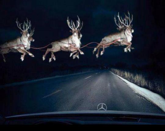
Deer Crossing of a Different Kind
Being one of the morning meteorologists at WeatherNation, I have always been a little worried about hitting deer a while driving into work . I've had several close calls, but thankfully I have a clean record and have stayed incident free. As I mentioned, I've seen my fair share of deer while night driving, but I can honestly say I've never seen anything like this!
Thanks to the NWS out of Alaska for this fun Facebook post from Christmas Day:
"Alaskans know Santa lives at North Pole, Alaska. But it's unusual for us to get pics of his training flights especially this close to the holiday."
See more HERE:
Severe Alaskan Cold
You think it's cold here, check out some of the low temps reported on December 26th across parts of central Alaska!
...COLDEST TEMPERATURES REPORTED IN THE INTERIOR DECEMBER 26TH
CHICKEN..........................................58 BELOW
TOK..............................................52 BELOW
DONNELLY.........................................50 BELOW
EAGLE............................................50 BELOW
DELTA JUNCTION...................................49 BELOW
FORT YUKON.......................................49 BELOW
NORTH POLE.......................................48 BELOW
CIRCLE HOT SPRINGS...............................42 BELOW
FAIRBANKS INTL AIRPORT...........................41 BELOW
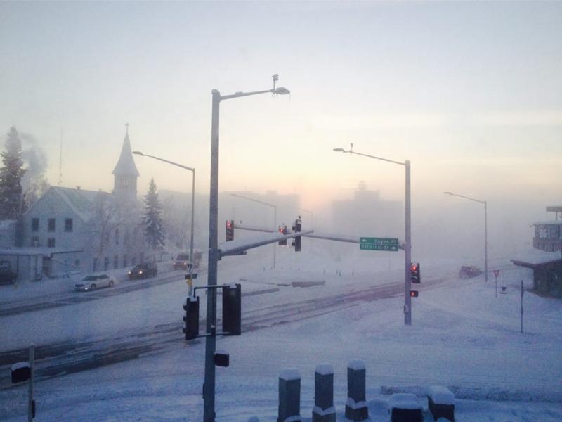
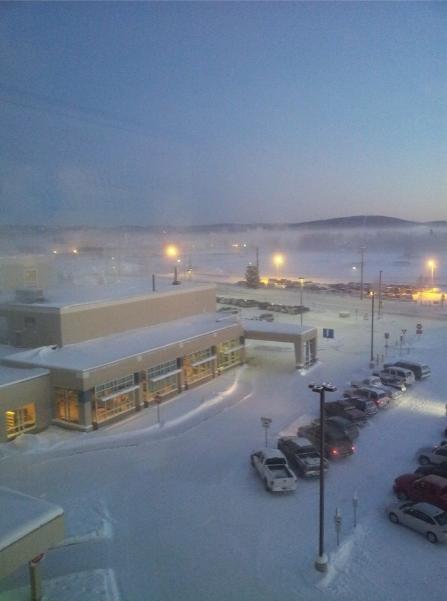
Alaskan Ice Fog
This was the icy view from downtown Fairbanks, Alaska on December 26th... Man, does that look cold!
(Image courtesy: Fairbanks Daily News-Miner)
See more HERE:
Here's another icy picture from Fairbanks, AK on the 27th. Thanks to Missey Wilt Kohler, who said it was -47F when she snapped the picture!
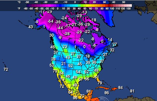
Coldest of the Cold
It's pretty apparent that from the map below, the coldest of the cold is still locked up in Alaska, but some of that cold is going to get dislodged over the next few days and make it's way into the Lower 48. The image below represents midday temperatures from Friday, December 27th.
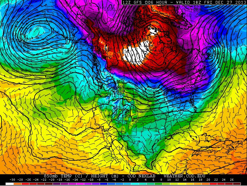
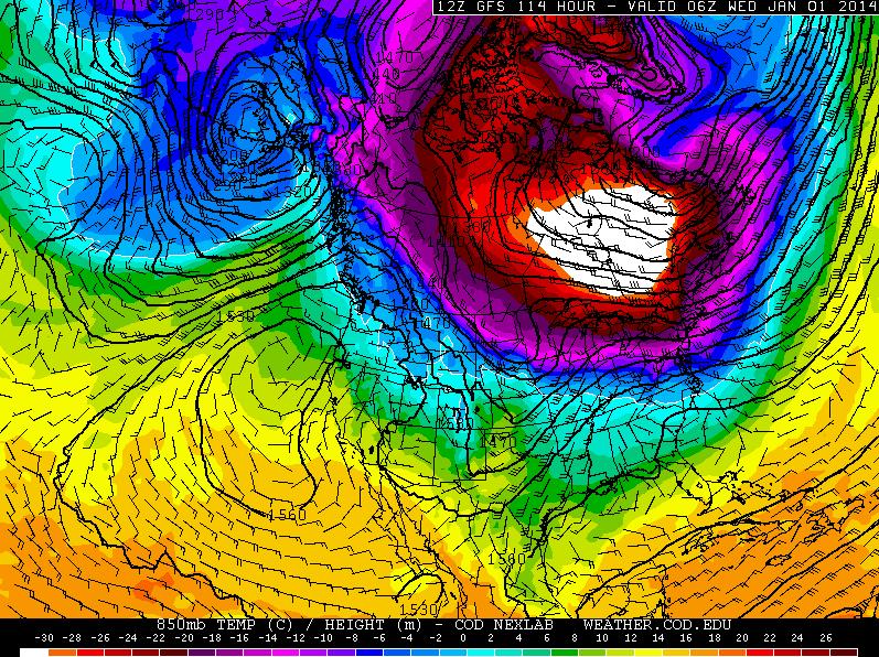
Tracking the Arctic Air
Here's how the cold air looks as it slams into the Lower 48 by late weekend/early next week.
Friday, December 27
Note that on Friday, the coldest of the cold was still locked up across the Arctic region, reflecting the coldest of the cold surface temperatures above.
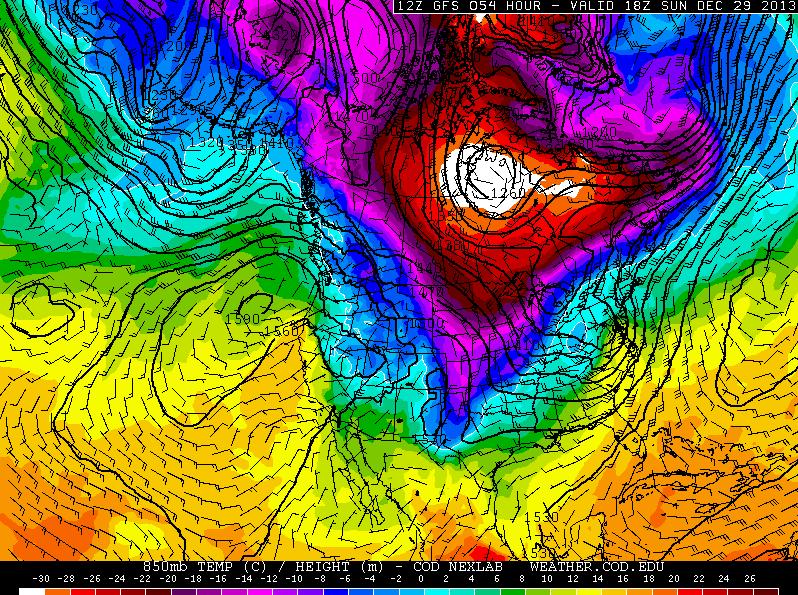
Sunday, December 29
By Sunday, the coldest temperatures still appear to be locked up well to our north, but note the finger of cold air poking down into the Lower 48 by midday Sunday!
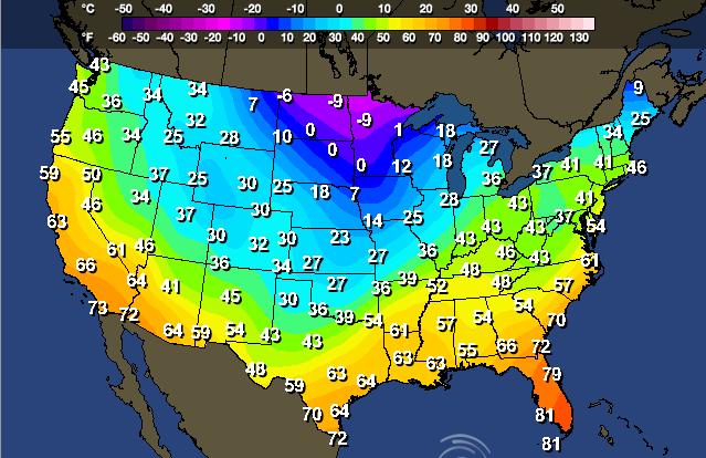
High Temperatures Sunday
Here are the forecast highs for Sunday, keep in mind that as the Arctic air settles southward, temperatures will likely fall through much of the day. Highs across parts of the Midwest will likely be reached early in the day.
Highs From Normal Sunday
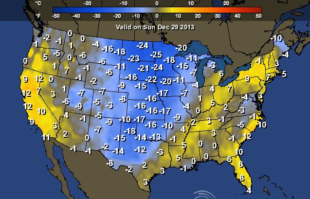
New Year's Eve Night
Here's a preview of what New Year's Eve night could harbor... It certainly doesn't look 'balmy' for folks in the northeastern quadrant of the nation does it?
Forecast Lows New Year's Eve Night
The good news is that the coldest of the cold still appears to be just north of the international border/Great Lakes region, but for folks heading out to watch the clock strike midnight in the northeastern quadrant of the nation, make sure to bundle up! Also keep in mind that these are just the temperatures, wind chill values will be quite a bit colder than what you see here!
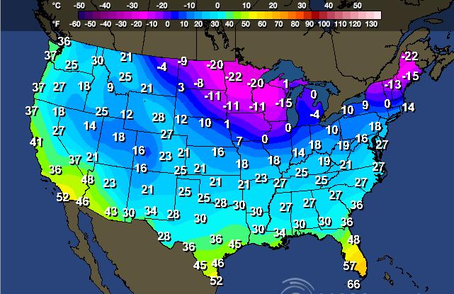
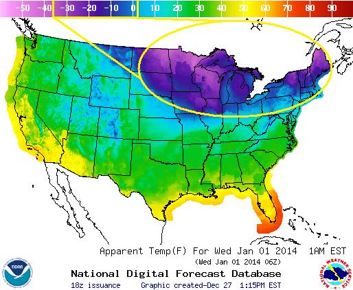
Feels Like Temp New Year's Eve Night
According to the NWS, here are what feels like temps could be on New Year's Eve Night! Note how large of an area could have sub-zero feels like temps then!
Enjoying Warmer Weather
While several folks will be bracing for colder weather over the coming days, there are still several warm spots across the nation. Here are a couple:
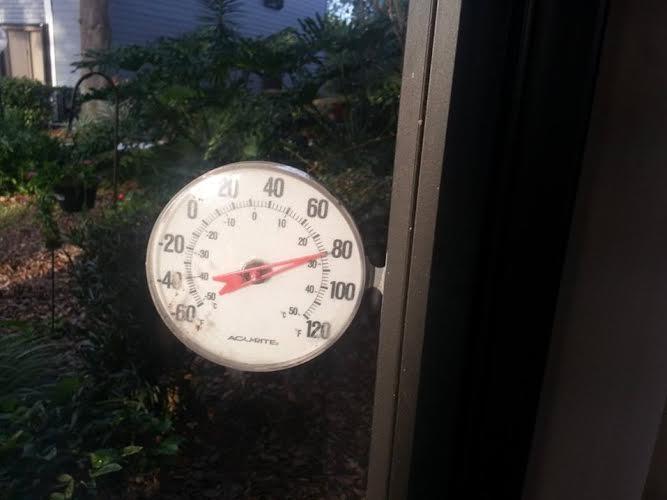
Thanks to my friend Sandra Westrum for this picture from near Wabasso, FL where the outdoor thermometer read near 80F earlier this week!
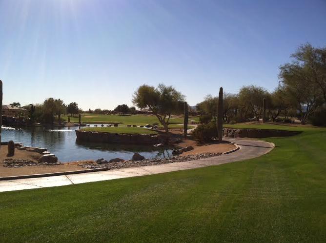
Golfing Weather
Thanks to my mom for her daily 'golf course' picture from Arizona... I'm starting to envy them now for deciding to become snowbirds this winter! Must be rough...
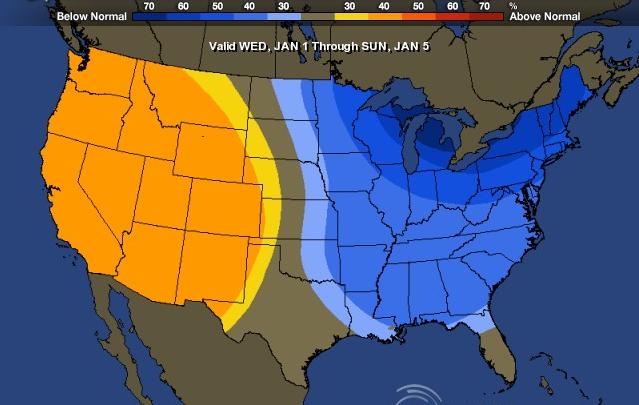
6 to 10 Day Temperature Outlook (Jan 1st - Jan 5th)
According to the NOAA, the 6 to 10 day temperature outlook shows a good chance that the western half of the nation will continue it's warmer than average ways into early January. On the other hand, it appears the eastern half of the nation has a pretty good chance to be MUCH cooler than average into early January.
California Stays Dry
Unfortunately, this warm weather means more 'mostly' dry weather for folks in the west. 2013 in California will likely wind up as one of the driest years/if not the driest on record!
Here's a good write-up from HuffingtonPost.com
"California precipitation has, on average, been declining, from an average of around 23 inches per year to around 21 inches per year -- a nearly 10 percent decline in the past 117 years."
Read more from HuffingtonPost.com HERE:
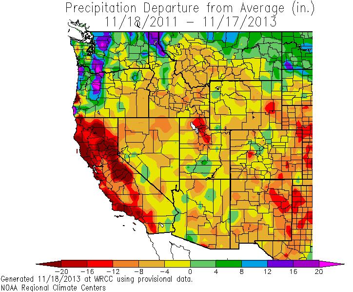
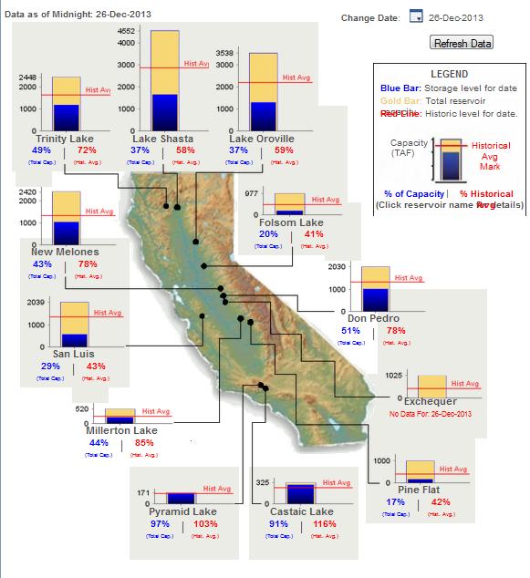
Here's another look at how dry it has been in California. These are reservoirs across the state, which show significantly low levels compared to the historical average to date.
See the current data from the California Data Exchange Center HERE:
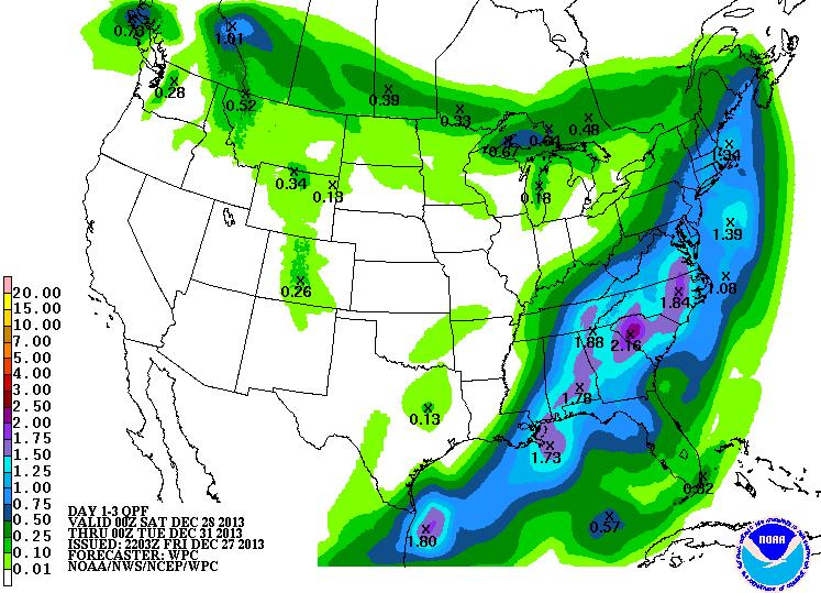
Eastern Rain
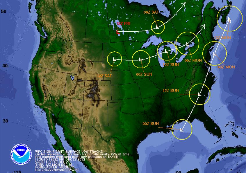
While folks in the west stay rather dry, folks in the eastern part of the country will be dealing with another waterlogged storm late this weekend/early next week. The bad news is that this low pressure from the Gulf of Mexico will likely impact travel on Sunday. The good news is that this will be mostly liquid as temperature profiles look warm
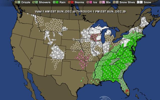
Sunday Forecast (1am - 1pm)
Here's the forecast for Sunday, note the big swath of rain from the Gulf Coast to the Northeast during that time. Another low pressure system will skid across the international border this weekend and bring some wintry precip to those areas...
3 Day Precipitation Forecast
NOAA's 3 day precipitation forecast suggests a widespread area of 1" to 2" rainfall amounts from the Gulf Coast to parts of the Northeast through early next week. This could certainly slow weekend travel down quite a bit...
Thanks for checking in and have a great weekend ahead!
Don't forget to check me out on Twitter @TNelsonWNTV

No comments:
Post a Comment