By Todd Nelson
Yup! It's Cold! The End!
If you weren't paying attention the weather forecast over the past few days, this Arctic blast may have come as more than a surprise. The plunge took us from daytime highs on Friday and Saturday (near 40F) that haven't been felt since late November to overnight lows Sunday thru early next week that could be the coldest of the season so far and haven't been reached in nearly 2yrs.
The coldest temperature so far this season (officially at the MSP Airport) was on Christmas Eve at -13F. Forecast lows at MSP could exceed that a couple of times and rival that of a -16F low temp set 2yrs. ago on January 21, 2011. If you're keeping track, according to NWS NOWData, the coldest temperature ever recorded in the Twin Cities was back in 1888, when the temperature dipped to -41 on January 21. More modern day records suggest that the coldest Minneapolis temperature was -34F set January 19, 1970. We will stay well above that extreme, but this cold will test your patience during the depths of a typical Minnesota winter.
The bitter cold sticks around for New Year's Eve and the start of 2014, but we begin to thaw out a bit by the end of next week -Todd Nelson
________________________________________________________________
SUNDAY: Another Canadian invasion. Harsh wind with blowing snow early. High: -1. Wind: NW 10-20. Wind Chill: -20F to -30F
SUNDAY NIGHT: Coldest night of the season? Low: -14. Wind: W 5-10. Wind Chill: Down to -30F
MONDAY: Frigid. Light snow possible. High: 2. Feels Like: -20F
TUESDAY: Patchy clouds, light snow possible in extreme southern MN. Wake-up: -13. High: -2
NEW YEAR'S EVE NIGHT: Chance of light snow southern MN, still very cold. -15. Feels like -20F
WEDNESDAY: Memorable cold start to 2014. High: 0.
THURSDAY: Peeks of sun, still Siberian Wake-up: -5. High: 4
FRIDAY: Feeling warmer, light PM snow. Wake-up: -3. High: 18.
SATURDAY: We're getting there, warmer yet! Wake-up: 12. High: 20.
__________________________________________________________________
This Day in Weather History
December 29th
1999: Minneapolis soars to a high temperature of 53 degrees.
_________________________________________________________________
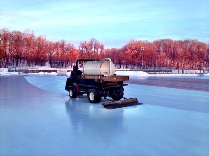
Nothing Better Than Fresh Ice
Ahh, there's at least one thing I like about Minnesota in winter and that's a good sheet of outdoor ice! I was up early enough to catch the outdoor Zamboni doing it's thing. This was prior to the record 47F high set at the MSP airport!
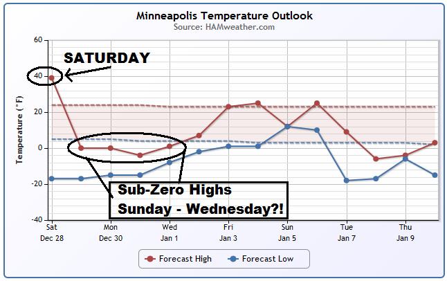
Typical Minnesota Winter Type Cold
I know we live in Minnesota and I know that this happens every year, but this one is going to sting a little. After a balmy Saturday (hope you enjoyed it), temperatures are going to be quite frigid until the end of the year. The start of 2014 doesn't look much better, but at least we may get above 0F for a daytime high by New Year's Day! Also note the blue line (minimum temperatures) and how they hover just above -20F for Minneapolis! We could certainly see our coldest night(s) of the season here!
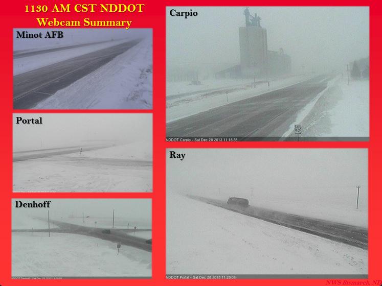
Blizzard Warnings...
Thanks to the National Weather Service out of Bismark, ND for the compilation of ND DOT cameras from midday Saturday. The images show the initial surge of Arctic air into the Lower 48 with near ground blizzard conditions as 30+mph wind gusts tore through the region.
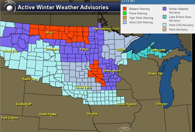
Here were all the blizzard warnings (in red) that were in place across the Upper Midwest through the weekend as the Arctic front plowed south.
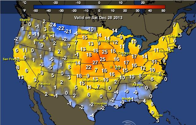
Cold Air Plunges South
WOW! What a front! Take a look at the high temperature from normal map across the nation from Saturday to Sunday. There's a 50F+ temperature swing there in just 1 day!
Highs From Normal Saturday
Look at how warm the central and eastern part of the country was from normal. Some even setting record highs!
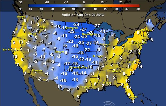
Highs From Normal Sunday
You know the cold front is powerful when it can drop temperatures as much as 50F+ in the other direction! Instead of being nearly 25F warmer than average, some spots will be nearly 25F colder than average on Sunday!
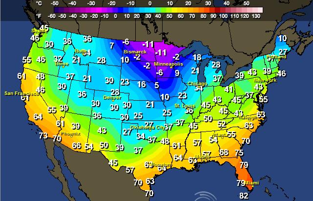
High Temperatures Sunday
Actual daytime high temperatures will have a tough time even reaching 0F across parts of the Upper Midwest!
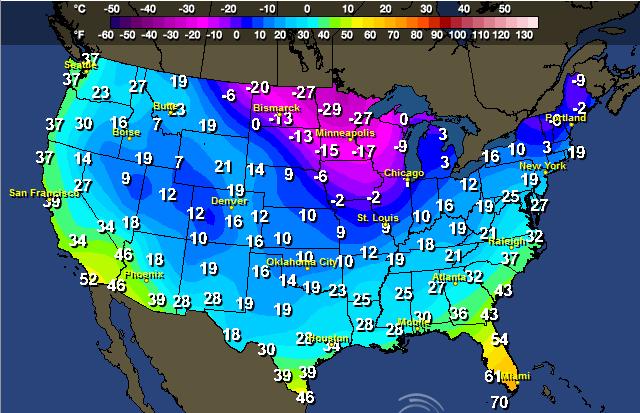
Forecast Lows Sunday Night
If you think that's cold, how about the forecast low temperatures for Sunday night! YIKES!
Waterlogged Eastern U.S.
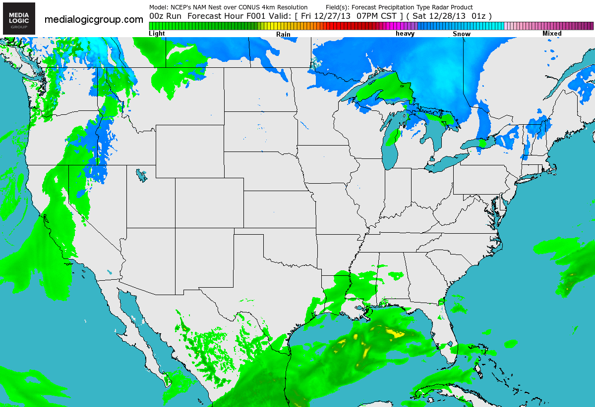
Take a look at the forecast radar below; note the big blob of moisture that pushed through the Southeast on Saturday and will wrap up over the Northeast on Sunday. The Arctic air mass from the Upper Mississippi Valley will help to bring a wintry mix from the Lower Mississippi Valley to parts of the Northeast on Sunday and Monday.
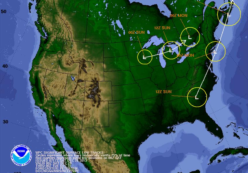
Tracking the Lows
These are the two storm systems that will be bringing inclement weather to the eastern half of the country through early next week. The southern Gulf low is the one that will bring the heaviest quantities of moisture to the eastern third of the country. Interestingly, it will be mixing with some colder air to the far north, so heavier snow is going to be an issue across parts of the Northern New England States through early next week as well! The northern low skipping across the Great Lakes Region is the low responsible for the Arctic invasion that will be permeating through the eastern part of the country through the New Year!
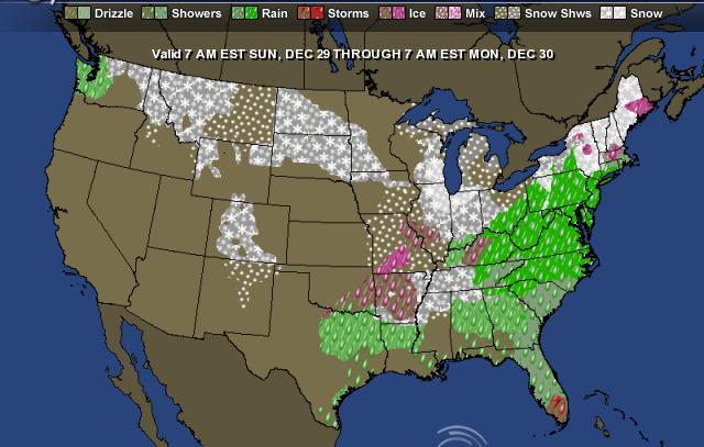
7am Sunday to 7am Monday
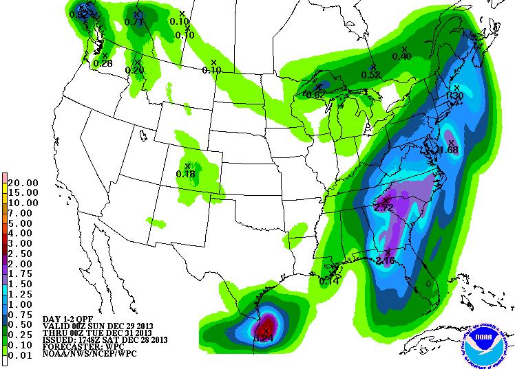
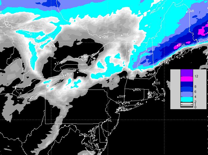
Precipitation Potential
According to NOAA's HPC 2 day precipitation forecast, from 7pm Saturday to 7pm Monday there will be a heavy swath of moisture from parts of the Mid-Atlantic to the Northeast. Some 1" to 2"+ amount can't be ruled out. This could certainly bring a few flooding concerns to the table where heavier rain accumulates. Keep in mind that some of this moisture will also be in the form of snow where colder temperatures exist across the far north.
Winter Storm Watch
The National Weather Service has issued a Winter Storm Watch for parts of the northern New England States for heavy snow potential of 6" to 10" from PM Sunday - AM Monday.
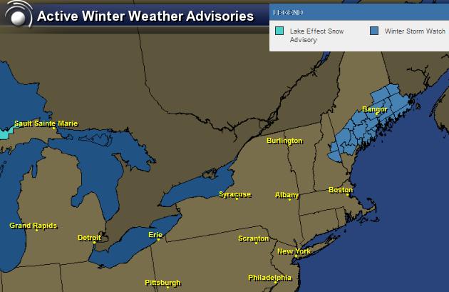
Snow accumulations through early next week look particularly interesting across parts of Maine. However, nuisance to shovelable snow may be possible from parts of the Great Lakes to the New England States during thru early next week.
Space Odyssey
It's not much, but it's kind of cool. It's a picture of the International Space Station as it flew over the National Weather Service office in Charleston, West Virginia

If you're interested in seeing the International Space Station or any other satellite with you're own eye, check out this cool website from SpaceWeather.com - All you have to do it put in your zipcode and it spits out the satellite that may be visible (weather permitting) in your area!
See more HERE:

Speaking of Space...
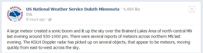
There were several reports of flashes in the sky and louds rumbles coming from the Upper Midwest on the night of December 27th. The National Weather Service out of Duluth, MN has a nice thread on what some encountered as an apparent meteorite dashed through the sky.
See More HERE:
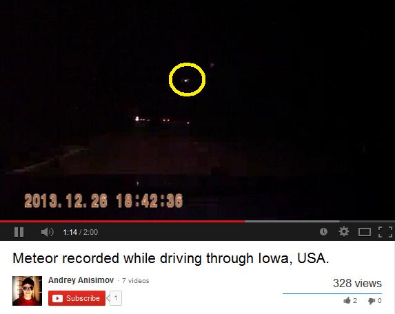
Meteorite From Iowa
Here's video of a meteorite from Iowa on the 26th of December
Video courtesy Andrey Anisimov - See HERE:
Purchase of the Day?
Not sure why some of us feel the need to have the biggest TV there is, but check this one out! It's an 85" and you can have it for only $40,000 !!
Check out the listing on Amazon HERE:

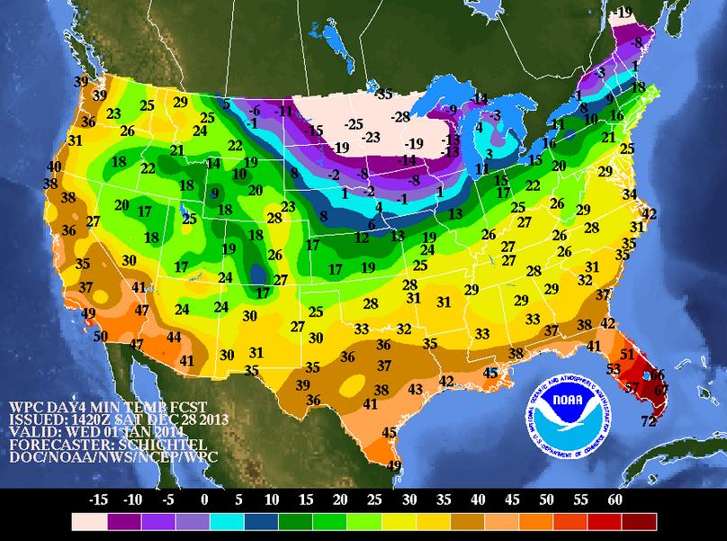
New Year's Eve Night Temperature Outlook
Here's the temperature outlook for New Year's Eve Night/AM New Year's Day. Note how cold it looks across parts of the Upper Midwest and the Northeast... YIKES!
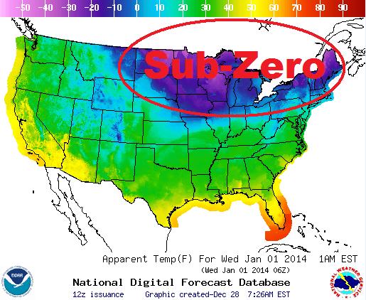
Here's the apparent temperature forecast for New Year's Eve Night near the time the clock strikes midnight... It looks pretty cold!
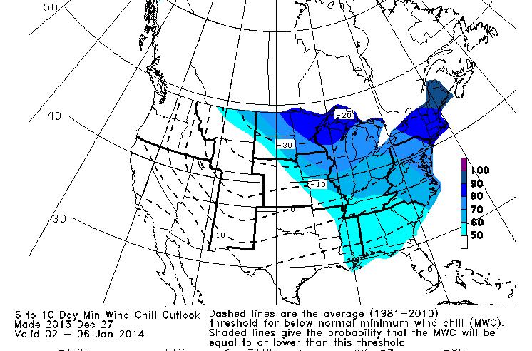
Early January Wind Chill Outlook
The extended wind chill outlook looks pretty cold through early January across much of the eastern part of the nation. According to NOAA, here are lowest wind chills possible from January 2nd - January 6
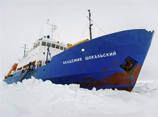
Antarctic Researchers Trapped
This is an interesting story coming from the bottom of the world, where a group of researchers are trapped in heavy sea ice!
"AN Antarctic rescue mission has suffered a setback after two icebreakers abandoned efforts to free a research ship stranded deep in sea ice.
A group of Australian scientists, explorers and tourists has been stuck on the Russian ship MV Akademik Shokalskiy since Christmas Day.
The ship, with 74 people on board, sent a distress call after becoming trapped in heavy sea ice, which has continued to expand around it over the past three days near Antarctica."
Read the full story from News.com.au HERE:
Thanks for checking in, have a great rest of your weekend and don't forget to follow me on Twitter @TNelsonWNTV

No comments:
Post a Comment