-67F. coldest wind chill ever observed in the Twin
Cities: January 22, 1936 (new formula). This would have been a wind
chill of -87F using the wind chill formula in use before 2001. Details
below.
Trouble on the Tundra
Can
you feel colder than numb? Not sure, but a wind chill this low cools
your skin and body core temperature down much faster, increasing the
risk of frostbite & hypothermia exponentially.
Check in on older friends and neighbors today to make sure they're staying warm.
Limit
or even eliminate time spent outside today. So often media reports of
crime, traffic tangles or severe storms exaggerate and hype the risk.
Not today. It's truly dangerous out there.
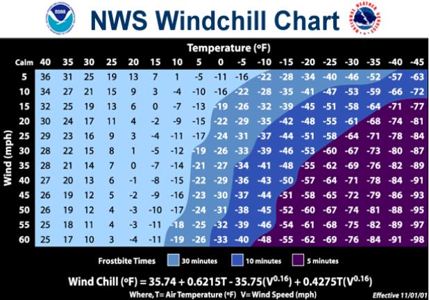
Arctic
scientists talk of a 30-30-30 Rule. A temperature of -30F with 30 mph
winds can freeze your skin in 30 seconds. It won't be quite that extreme
out there today - but close; frostbite certainly possible on exposed
skin within a couple of minutes this morning.
The all-time MSP
wind chill record is -67F, set January 22, 1936. That's using the new,
warmer wind chill formula. Old, pre-2001 formula? -87.
It won't
get THAT cold, but an air temperature of -25F coupled with 25 mph winds
will make it feel like -50 to -55F early this morning.
Call in sick (of winter). I'll write you a note.
Storms
will strafe Chicago and the Great Lakes, but no big snowfalls are
imminent here, just a badly needed thaw, with 30s this weekend and much
of January.
One small silver lining: the mercury has to reach -40F or colder to kill off beetle pests in Minnesota's North Woods.
RIP bugs.
Windchill Warning.
Check out the (very) strongly worded statement from the Twin Cities
National Weather Service. Never tell a Minnesotan to not go outside -
with the possibly exception of today:
...HISTORIC AND LIFE-THREATENING COLD AIR HAS ARRIVED...
...THIS IS A PARTICULARLY DANGEROUS SITUATION...

.A WIND CHILL WARNING REMAINS IN EFFECT FOR CENTRAL AND SOUTHERN
MINNESOTA AND WEST CENTRAL WISCONSIN THROUGH NOON TUESDAY.

THE COLDEST AIRMASS SINCE 1996 IS MOVING INTO THE REGION AND WILL
BE WITH US INTO TUESDAY. WIND CHILL VALUES TODAY WILL RANGE FROM
30 BELOW TO 45 BELOW ZERO. TEMPERATURES TONIGHT WILL BOTTOM OUT IN
THE 20S AND 30S BELOW ZERO WITH ONLY A SMALL RECOVERY ON MONDAY.
THE ARCTIC COLD TONIGHT AND MONDAY WILL BE ACCOMPANIED BY BRISK
NORTHWEST WINDS. THE COMBINATION OF THE COLD AND WIND WILL PRODUCE
WIND CHILLS OF 50 BELOW TO 65 DEGREES BELOW.

THIS IS A LIFE THREATENING SITUATION IF YOU BECOME STRANDED. WIND
CHILLS COLDER THAN 50 BELOW CAN CAUSE EXPOSED FLESH TO FREEZE IN
ONLY 5 MINUTES. COVER AS MUCH FLESH AS POSSIBLE WHEN VENTURING OUT
OVER THE NEXT FEW DAYS.

THE GUSTY WINDS WILL ALSO BRING AREAS OF BLOWING SNOW TO MUCH OF
THE AREA THIS AFTERNOON AND TONIGHT. WIND GUSTS MAY REACH 35 TO 45
MPH OVER WESTERN AND SOUTHERN MINNESOTA. AS A RESULT...VISIBILITIES
MAY BE REDUCED AT TIMES TO LESS THAN A HALF MILE...WITH NEAR
BLIZZARD CONDITIONS. THIS WILL BRING AN ADDITIONAL LEVEL OF DANGER
TO ANYONE STRANDED.
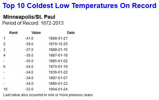 Coldest Nighttime Mins Ever Observed At MSP
. Here's the dreaded Top 10 list, courtesy of
NOAA and the Minnesota Climatology Office. I'm somewhat relieved we won't make this list.
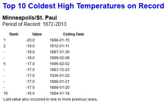
Coldest Daytime Highs At MSP.
We may come close to making this Top 10 List, with a predicted "high"
of -13 to 15F today, the coldest day of the winter, possibly the coldest
day since the mid 90s.
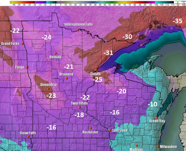
Early Morning Air Temperatures.
You may spot a few polar bear if you're out and about this morning,
wake-up temperatures ranging from -16 to -27 across the metro (the urban
heat island will keep the immediate downtowns a few degrees warmer). Up
north some -30s are expected. Map: NOAA NAM guidance and Ham Weather.
 Slow Moderation By Midweek
.
Then again temperatures have nowhere to go but up. The solid green line
marks the 0F isotherm, solid red shows readings colder than -20F,
pushing into the western suburbs of the Twin Cities this morning. The
core of the coldest arctic air begins to lift north by Wednesday.
Animation: NOAA and Ham Weather.
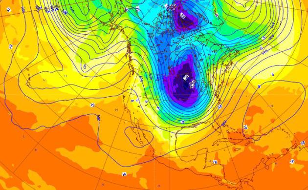
Ridiculously Cold For Much Of America.
On average temperatures bottom out the third week of January, so this
rude blast of Siberian air is coming 1-2 weeks earlier than usual. I
still believe this will be the coldest of winter, possibly the coldest
in nearly 2 decades from the Upper Midwest into the Great Lakes, subzero
readings as far south as the mountains of northern Georgia, as far east
as Baltimore and Worcester.
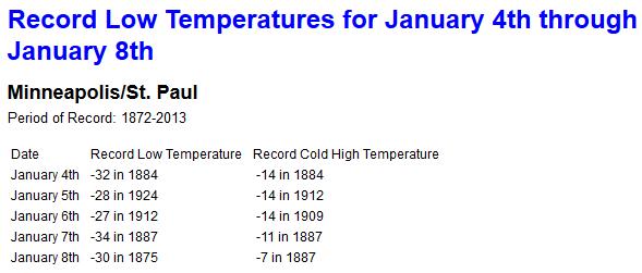
Record Territory.
We'll come close to setting the all-time record low this morning,
January 6 - a better chance of setting a record for the coldest maximum
temperature tomorrow (previous record is -14F set in 1909). Data: NOAA.
Historic Wind Chill Temperatures In Minnesota. Details from the
Minnesota Climatology Working Group: "
What
is the coldest windchill ever seen in the Twin Cities or Minnesota? The
answer can be a little tricky because on November 2001 the formula on
how to calculate the windchill
was changed. Perhaps the coldest windchill the Twin Cities has ever
seen was -67 degrees F with the new formula (-87 degrees F with the old
formula) back on January 22nd 1936. The temperature was -34 degrees F
with a wind speed of 20mph. All traffic in the Twin Cities was severely
hampered and a number of fatalities were caused by the cold. Without a
lengthy state-wide wind record, it is difficult to say when was the
coldest statewide windchill. There are some candidate dates though
besides January 22, 1936. On January 9th and 10th, 1982 temperatures of
-30 degrees F and winds of around 40mph were reported in Northern
Minnesota. This would translate to -71 degrees F by the new formula
(-100 degrees F by the old formula.)..."
* more details on how the wind chill is derived from NOAA
here.
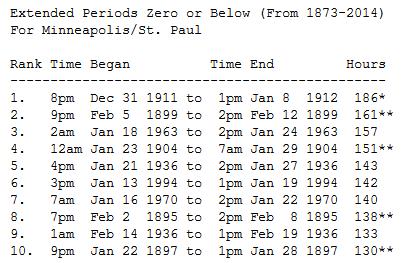
Extended Period Of Zero Or Below In The Twin Cities: 1873-2014. Here's an excerpt of an interesting post from the
Twin Cities National Weather Service: "
The
mercury has stayed at or below zero for at least four consecutive days
on 27 occasions in the Twin Cities from 1873 to 2014. The longest streak
is seven days from January 1-7, 1912. For the number of consecutive hours
that the temperature has stayed at or below zero, the 1912 stretch is
the longest at 186 hours. The last time there was a stretch that lasted
longer than 4 days was 142 hours in 1994. More recent stretches include
86 hours from 11pm January 12, 2009 to 1pm January 16, 2009 and 93 hours
from 5pm January 31, 1996 to 1pm February 4, 1996. How long would a
stretch of zero or below weather be to make the top ten list? The
mercury would have to stay at or below zero for at least FOUR full
calendar days to have a chance of making the list..."
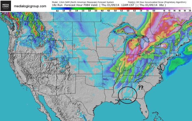
Flurries For The Florida Panhandle?
I vividly remember enough flurries in Miami Beach, Florida to build a
small snow man back during the winter of 1976. Locals were stunned,
shocked, horrified. This time around enough cold air may pour south for a
few flurries as far south as Pensacola and Mobile. Heavier snow, enough
to shovel and plow, is expected from near Indianapolis to Detroit as
this rush of record-breaking cold arrives. Map: NOAA's NAM guidance,
courtesy of Ham Weather.
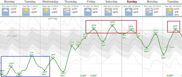
Weekend Correction.
As fast as we tumbled over a temperature cliff temperatures are
forecast to moderate by the weekend; ECMWF guidance shows high
temperatures near or just above freezing Friday into Monday, relatively
mild weather and a Pacific-influenced breeze spilling over into much of
next week. Graphic: Weatherspark.
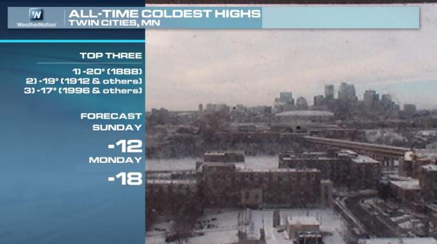
Coldest Modern-Day Highs In The Twin Cities.
The all-time record for coldest maximum temperatures is -20F in 1888.
In 1996 MSP experienced a high of -17F. We may come close to these
extreme values on Monday. Graphic: WeatherNation TV.
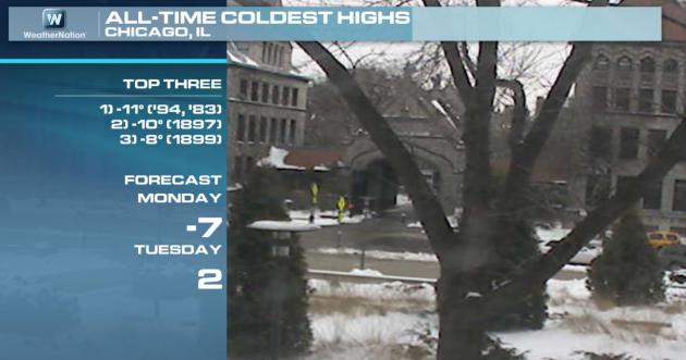
Coldest Days In Chicago.
The Windy City will come very close to setting a record for one of the 3
coldest days every observed in modern-day records, according to NOAA
records. Graphic: WeatherNation TV.
Subzero Streaks In Chicago. This may wind up being a Top 10 Subzero Event for Chicago, possibly the longest streak below zero since 1996. Source: NOAA.
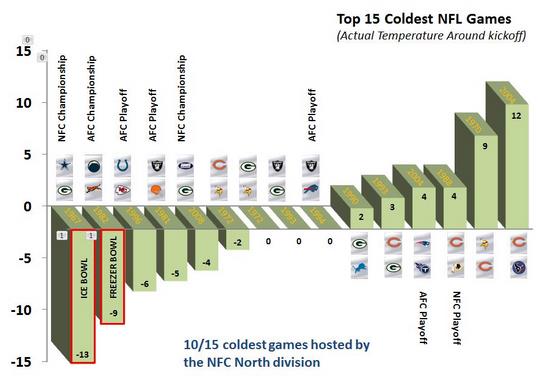
Windchill, Temperature, And The Coldest Games In NFL History. Here's a timely recap of some of the coldest NFL games every played, courtesy of the
Green Bay office of the National Weather Service: "
Let's
briefly take a look at some of the coldest games in NFL History with
respect to temperature and wind chill values. The chart (above) shows
the top 15 coldest NFL games based on the actual air temperature (degrees F) around game time. As you can see, based on the actual air temperature, the top two coldest games were the 1967 Ice Bowl (Cowboys vs Packers) and the 1982 Freezer Bowl
(Chargers vs Bengals). Although the 1967 Ice Bowl was colder based on
the actual temperature, some have argued that the 1982 Freezer Bowl was
actually the colder of the two games because the winds were stronger
during the game, thereby creating lower windchill values. Let's take a
closer look at these two nasty weather playoff games with respect to
temperature and wind chill..."
TODAY: Windchill Warning.
Dangerously cold. Coldest Jan. 6 on record for much of Minnesota? Feels like -40 to 50F early. Winds: NW 15-25. High: -15
MONDAY NIGHT: Windchill Warning. Partly cloudy - still frigid. Low: -20
TUESDAY: Windchill Warning until noon. More sun, less wind. Feels like -35F. High: -3
WEDNESDAY: Blue sky. Hello zero! Wake-up: -12. High: 4
THURSDAY: Some sun, not nearly as harsh. Wake-up: -3. High: 17
FRIDAY: Mostly cloudy, risk of a thaw. Wake-up: 13. High: 32
SATURDAY: Dripping icicles. Much better. Wake-up: 20. High: 34
SUNDAY: Cloudy, above average temps. Wake-up: 26. High: 32
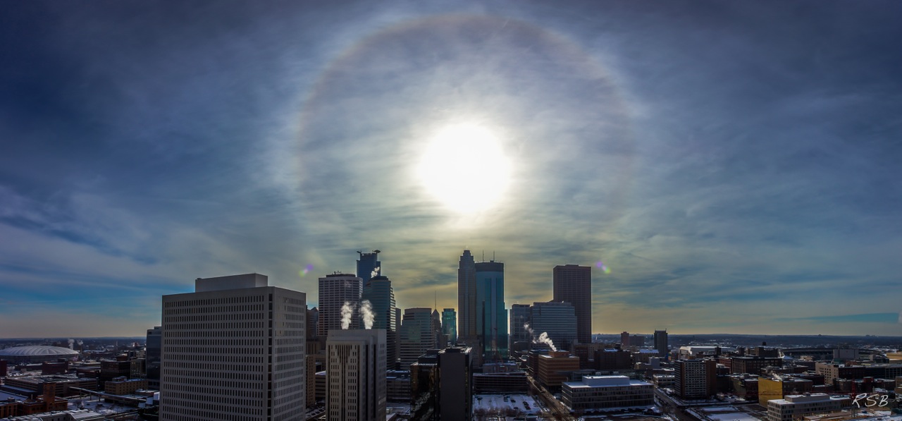
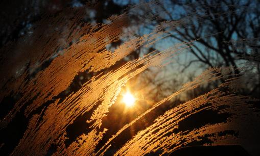
* photo courtesy of Steve Burns.

No comments:
Post a Comment