35 F. high early Saturday in the Twin Cities.
24 F. average high on January 4.
30 F. high on January 4, 2013.
Trace of snow fell yesterday.
6" snow on the ground at MSP.
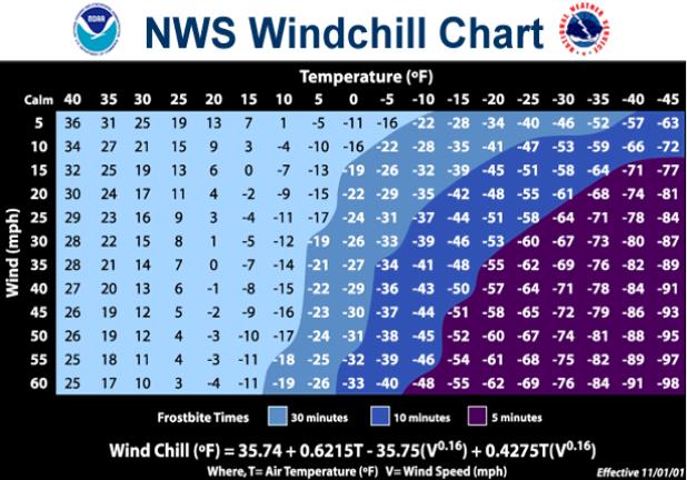
-67F. coldest wind chill ever observed in the Twin
Cities: January 22, 1936 (new formula). This would have been a wind
chill of -87F using the wind chill formula in use before 2001. Details
below.
Polar Displacement
To
be fair, we don't have to worry about hurricanes, earthquakes or
volcanoes. But once every decade or two the North Pole shifts south,
temporarily, leaving all of us scrambling for cover and a warm, safe
place to hibernate for a few days.
All those tales of frigid
hardship your grandparents scared you with growing up will come true
over the next 36 hours as the "polar vortex" - air that should be over
the Arctic Circle - sails over our heads.
Pluto, with lakes.
According
to NOAA the mercury has stayed at or below zero for at least four
consecutive days on 27 occasions in the Twin Cities from 1873 to 2014.
The record? 1 week below zero in 1912.
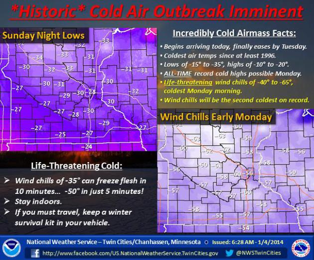
What makes this cold wave
notable and potentially historic is a strong pressure gradient whipping
up a stubbornly evil wind of 15-25 mph. With air temperatures near -25F
early Monday that will make for an otherworldly wind chill of -55F.
Exposed skin can become frostbitten in 5 minutes.
Closing
down Minnesota schools Monday was a good idea. And if your car stalls
or breaks down call 911 or AAA. Wait for help to reach you.
We top
zero on Wednesday; 30s this weekend will feel toasty. For the record,
this is the worst of winter, possibly the coldest air since 1996.
Think warm thoughts. Be careful out there.
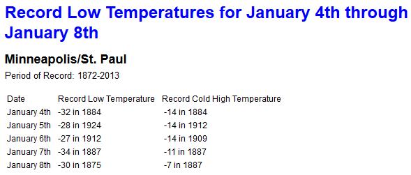 Record Territory
.
We'll come close to setting the all-time record low for Monday, January
6 - a better chance of setting a record for the coldest maximum
temperature tomorrow (previous record is -14F set in 1909). Data: NOAA.
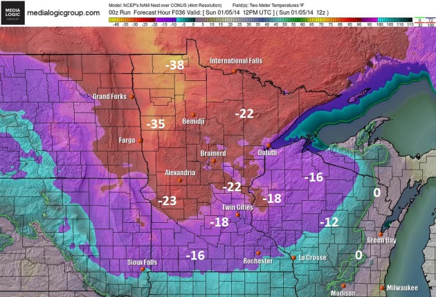
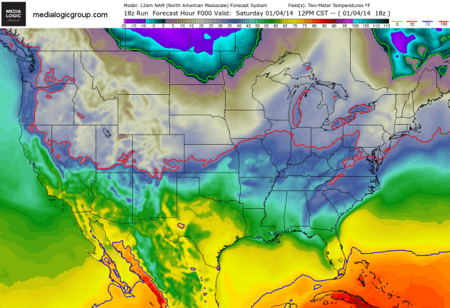
Sunday Morning Temperatures.
NOAA's NAM model shows readings ranging from -15 to -22F in the Twin
Cities metro, with readings as cold as -35 to -38F over the Red River
Valley. These are projected air temperatures. A stubborn 20 mph wind
will create wind chill values in the -35 to -60 range. Map: Ham Weather.
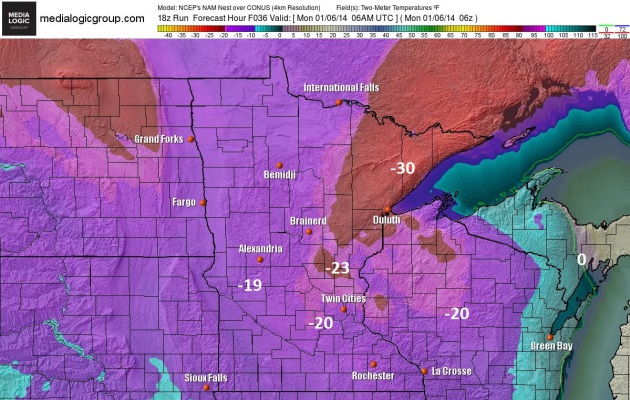
Morning Morning - Pluto With Lakes.
Temperatures bottom out across the Twin Cities metro Monday morning in
the -20 to -25F range, some of the coldest temperatures since the
mid-90s. Factor in a 20 mph wind and you have a chill factor of -50 to
-55F. Frostbite is possible in under 5 minutes.
A Serious Arctic Outbreak.
Subzero readings are likely as far south as the Ohio River, as far east
as Philadelphia and Albany. Sub-freezing temperatures (solid red line
is 32F isother) penetrate as far south as Brownsville and the suburbs of
Orlando, Florida. Animation: NOAA 2-meter temperatures, courtesy of Ham
Weather.
Historic Wind Chill Temperatures In Minnesota. Details from the
Minnesota Climatology Working Group: "
What
is the coldest windchill ever seen in the Twin Cities or Minnesota? The
answer can be a little tricky because on November 2001 the formula on
how to calculate the windchill
was changed. Perhaps the coldest windchill the Twin Cities has ever
seen was -67 degrees F with the new formula (-87 degrees F with the old
formula) back on January 22nd 1936. The temperature was -34 degrees F
with a wind speed of 20mph. All traffic in the Twin Cities was severely
hampered and a number of fatalities were caused by the cold. Without a
lengthy state-wide wind record, it is difficult to say when was the
coldest statewide windchill. There are some candidate dates though
besides January 22, 1936. On January 9th and 10th, 1982 temperatures of
-30 degrees F and winds of around 40mph were reported in Northern
Minnesota. This would translate to -71 degrees F by the new formula
(-100 degrees F by the old formula.)..."
* more details on how the wind chill is derived from NOAA
here.
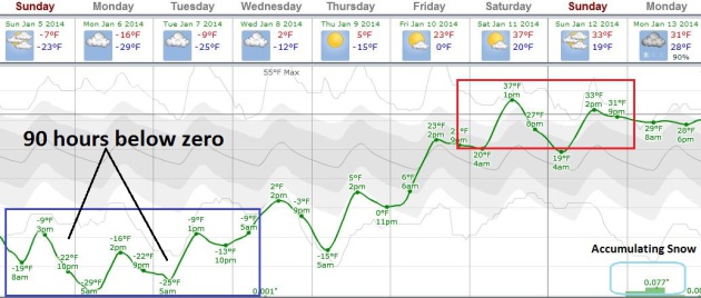
90+ Consecutive Hours Below Zero.
We'll go 3-4 days in a row below zero, the first chance of rising above
0F coming during the afternoon hours on Wednesday. It will warm up as
fast as it cooled down; highs in the 30s by the weekend. Graph:
Weatherspark.
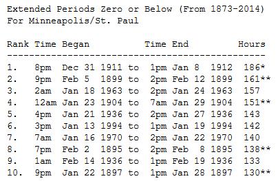
Extended Period Of Zero Or Below In The Twin Cities: 1873-2014. Here's an excerpt of an interesting post from the
Twin Cities National Weather Service: "
The
mercury has stayed at or below zero for at least four consecutive days
on 27 occasions in the Twin Cities from 1873 to 2014. The longest streak
is seven days from January 1-7, 1912. For the number of consecutive hours
that the temperature has stayed at or below zero, the 1912 stretch is
the longest at 186 hours. The last time there was a stretch that lasted
longer than 4 days was 142 hours in 1994. More recent stretches include
86 hours from 11pm January 12, 2009 to 1pm January 16, 2009 and 93 hours
from 5pm January 31, 1996 to 1pm February 4, 1996. How long would a
stretch of zero or below weather be to make the top ten list? The
mercury would have to stay at or below zero for at least FOUR full
calendar days to have a chance of making the list..."
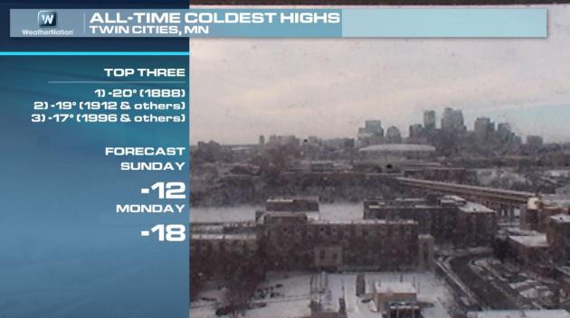
Coldest Modern-Day Highs In The Twin Cities.
The all-time record for coldest maximum temperatures is -20F in 1888.
In 1996 MSP experienced a high of -17F. We may come close to these
extreme values on Monday. Graphic: WeatherNation TV.
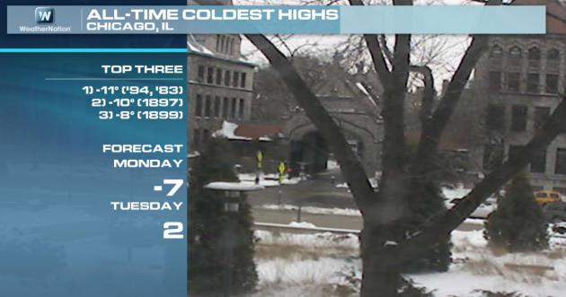
Coldest Days In Chicago.
The Windy City will come very close to setting a record for one of the 3
coldest days every observed in modern-day records, according to NOAA
records. Graphic: WeatherNation TV.
Subzero Streaks In Chicago. This may wind up being a Top 10 Subzero Event for Chicago, possibly the longest streak below zero since 1996. Source: NOAA.
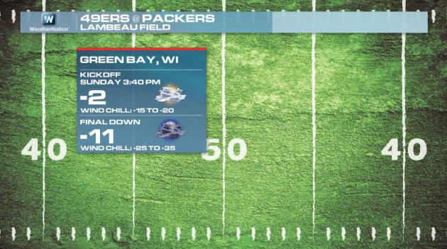
Tundra-Bowl.
Although not the coldest NFL game ever played, Sunday's game should be
entertaining (to watch), with wind chills in Green Bay forecast to drop
as low as -35. Expect both Green Bay and the 49'ers to focus on their
running game.
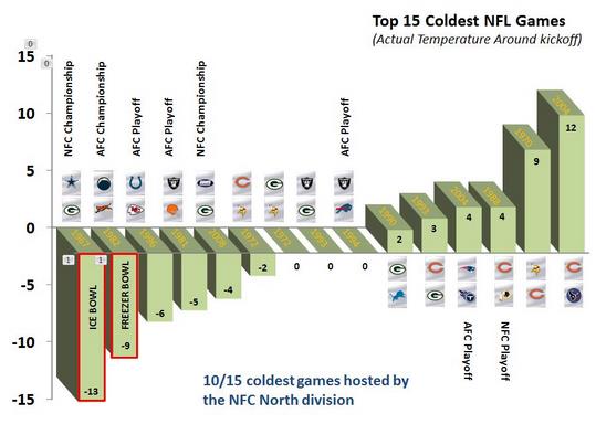
Windchill, Temperature, And The Coldest Games In NFL History. Here's a timely recap of some of the coldest NFL games every played, courtesy of the
Green Bay office of the National Weather Service: "
Let's
briefly take a look at some of the coldest games in NFL History with
respect to temperature and wind chill values. The chart (above) shows
the top 15 coldest NFL games based on the actual air temperature (degrees F) around game time. As you can see, based on the actual air temperature, the top two coldest games were the 1967 Ice Bowl (Cowboys vs Packers) and the 1982 Freezer Bowl
(Chargers vs Bengals). Although the 1967 Ice Bowl was colder based on
the actual temperature, some have argued that the 1982 Freezer Bowl was
actually the colder of the two games because the winds were stronger
during the game, thereby creating lower windchill values. Let's take a
closer look at these two nasty weather playoff games with respect to
temperature and wind chill..."
TODAY:
Windchill Warning. Dangerously cold with some sun. Feels like -35F. High: -10
SUNDAY NIGHT:
Windchill Warning. Frigid - high risk of frostbite and hypothermia. Low: -26
MONDAY:
Windchill Warning. Records break. Feels like -55F. High: -15
TUESDAY: More sun, not quite as brutal. Wake-up: -21. High: -5
WEDNESDAY: Happy to see zero. Few flakes. Wake-up: -14. High: 3
THURSDAY: Blue sky, emerge from hibernation. Wake-up: -6. High: 12
FRIDAY: Patchy clouds, above average. Wake-up: 8. High: 25
SATURDAY: January Thaw. Dripping icicles! Wake-up: 17. High: 33

No comments:
Post a Comment